ラス・アメリカス
Americas
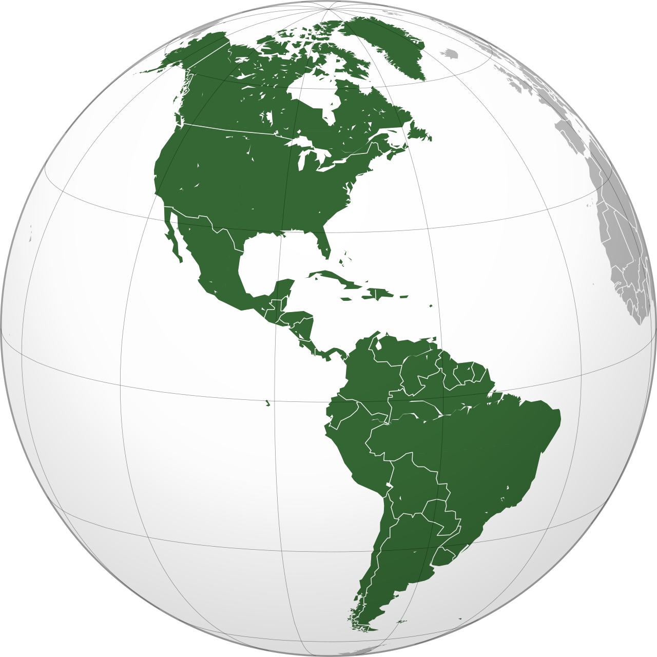
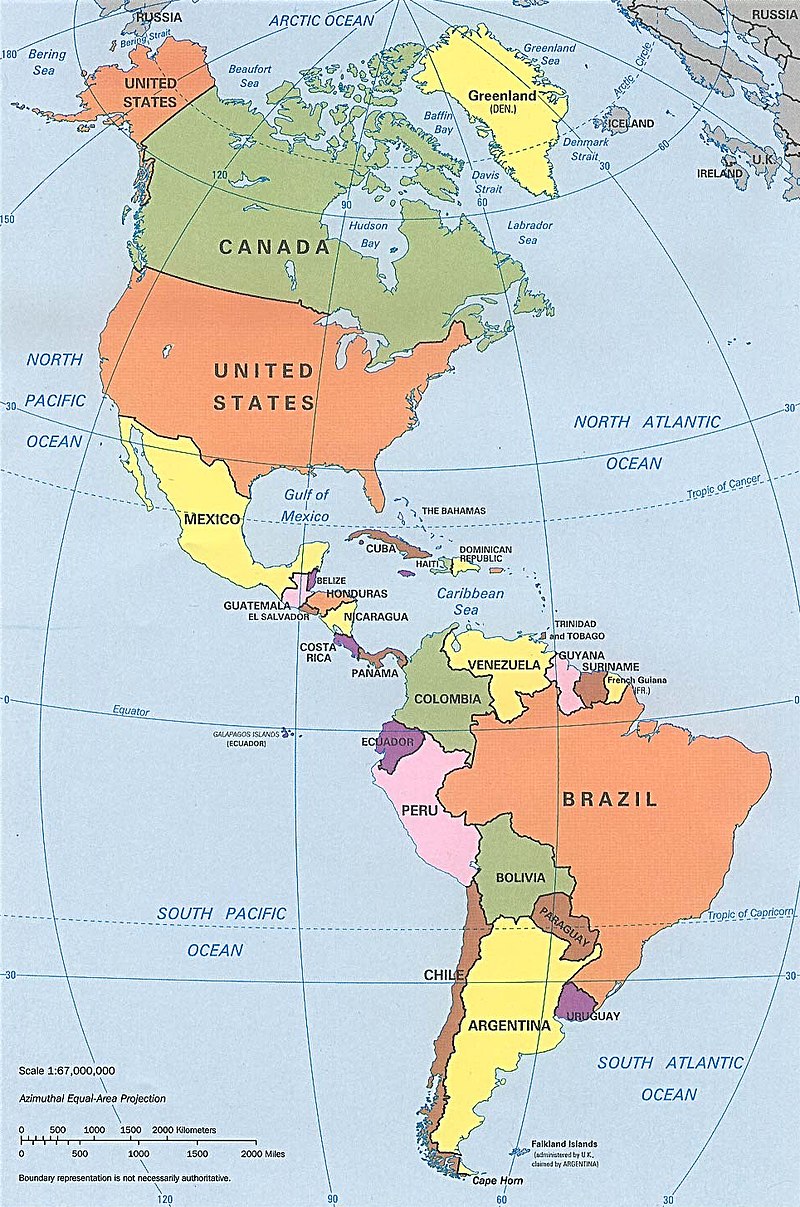
Orthographic map of the Americas with national borders added / 1990s CIA political map of the Americas in Lambert azimuthal equal-area projection
☆ アメリカ州(アメリカしゅう、The Americas)[スペイン語では Las Americas] は、北アメリカ大陸と南アメリカ大陸を合わせた大陸である。単一の大陸として見た場合、アメリカ州(アメリカ)はアジアに次いで2番目に面積が大きく、人 口では3番目に大きな大陸である。アメリカ州は地球の西半球の大部分の陸地を占め、新大陸を構成している。 関連する島々を含めると、アメリカ大陸は地球の表面積の8%、陸地の28.4%を占める。地形はアメリカ山脈(アメリカ山脈)と呼ばれる、西海岸に沿って 連なる長い山脈が支配的である。アメリカ大陸の東側の平野部には、アマゾン川、セントローレンス川-五大湖、ミシシッピ川、ラプラタ川などの大河川流域が 広がっている。南北に14,000km(8,700マイル)にわたって広がるアメリカ大陸では、カナダ北部、グリーンランド、アラスカの北極圏ツンドラ気 候から、中央アメリカや南アメリカの熱帯雨林気候まで、気候や生態系は多岐にわたっている。
| The Americas,
sometimes collectively called America,[3][4][5] are a landmass
comprising the totality of North America and South America.[6][7][8]
When viewed as a single continent, the Americas or America is the 2nd
largest continent by area after Asia, and is the 3rd largest continent
by population. The Americas make up most of the land in Earth's Western
Hemisphere and comprise the New World.[3] Along with their associated islands, the Americas cover 8% of Earth's total surface area and 28.4% of its land area. The topography is dominated by the American Cordillera, a long chain of mountains that runs the length of the west coast. The flatter eastern side of the Americas is dominated by large river basins, such as the Amazon, St. Lawrence River–Great Lakes, Mississippi, and La Plata basins. Since the Americas extend 14,000 km (8,700 mi) from north to south, the climate and ecology vary widely, from the arctic tundra of Northern Canada, Greenland, and Alaska, to the tropical rainforests in Central America and South America. Humans first settled the Americas from Asia between 20,000 and 16,000 years ago. A second migration of Na-Dene speakers followed later from Asia. The subsequent migration of the Inuit into the neoarctic c. 3500 BCE completed what is generally regarded as the settlement by the Indigenous peoples of the Americas. The first known European settlement in the Americas was by the Norse explorer Leif Erikson.[9] However, the colonization never became permanent and was later abandoned. The Spanish voyages of Christopher Columbus from 1492 to 1504 resulted in permanent contact with European (and subsequently, other Old World) powers, which eventually led to the Columbian exchange and inaugurated a period of exploration, conquest, and colonization whose effects and consequences persist to the present. The Spanish presence involved the enslavement of large numbers of the indigenous population of America.[10] Diseases introduced from Europe and West Africa devastated the indigenous peoples, and the European powers colonized the Americas.[11] Mass emigration from Europe, including large numbers of indentured servants, and importation of African slaves largely replaced the indigenous peoples in much of the Americas. Decolonization of the Americas began with the American Revolution in the 1770s and largely ended with the Spanish–American War in the late 1890s. Currently, almost all of the population of the Americas resides in independent countries; however, the legacy of the colonization and settlement by Europeans is that the Americas share many common cultural traits, most notably Christianity and the use of West European languages: primarily Spanish, English, Portuguese, French, and, to a lesser extent, Dutch. The Americas are home to more than a billion inhabitants, two-thirds of whom reside in the United States, Brazil, and Mexico. It is home to eight megacities (metropolitan areas with 10 million inhabitants or more): Greater Mexico City (21.2 million), São Paulo (21.2 million), New York City (19.7 million), Los Angeles (18.8 million), Buenos Aires (15.6 million),[12] Rio de Janeiro (13.0 million), Bogotá (10.4 million), and Lima (10.1 million). |
アメリカ州(アメリカしゅう,ラス・アメリカス)は、北アメリカ大陸と南アメリカ大陸を
合わせた大陸である。単一の大陸として見た場合、アメリカ州(アメリカ)はアジアに次いで2番目に面積が大きく、人口では3番目に大きな大陸である。アメ
リカ州は地球の西半球の大部分の陸地を占め、新大陸を構成している。 関連する島々を含めると、アメリカ大陸は地球の表面積の8%、陸地の28.4%を占める。地形はアメリカ山脈(アメリカ山脈)と呼ばれる、西海岸に沿って 連なる長い山脈が支配的である。アメリカ大陸の東側の平野部には、アマゾン川、セントローレンス川-五大湖、ミシシッピ川、ラプラタ川などの大河川流域が 広がっている。南北に14,000km(8,700マイル)にわたって広がるアメリカ大陸では、カナダ北部、グリーンランド、アラスカの北極圏ツンドラ気 候から、中央アメリカや南アメリカの熱帯雨林気候まで、気候や生態系は多岐にわたっている。 人類が初めてアジアからアメリカ大陸に移住したのは、今から2万~1万6千年前のことである。その後、アジアからナ・デネ語族の移住が続いた。紀元前 3500年頃には、イヌイットが新北極圏に移住し、これがアメリカ大陸の先住民による定住と一般的に考えられている。アメリカ大陸におけるヨーロッパ人の 最初の入植は、ノルウェー人の探検家レイフ・エリクソンによるものであった。[9] しかし、その植民地化は永続的なものとはならず、後に放棄された。1492年から1504年にかけてのクリストファー・コロンブスのスペインによる航海 は、ヨーロッパ(およびその後、他の旧世界)の諸国との永続的な接触をもたらし、最終的にコロンブス交換を引き起こし、探検、征服、植民地化の時代が始 まった。その影響と結果は現在まで続いている。 スペイン人の存在は、アメリカ大陸の先住民の多くを奴隷化することにつながった。[10] ヨーロッパや西アフリカから持ち込まれた病気が先住民を壊滅させ、ヨーロッパ諸国はアメリカ大陸を植民地化した。[11] ヨーロッパからの大量移住(多数の契約労働者を含む)とアフリカ人奴隷の輸入により、アメリカ大陸の大部分で先住民はほぼ置き換えられた。アメリカ大陸の 脱植民地化は1770年代のアメリカ独立革命から始まり、1890年代後半の米西戦争でほぼ完了した。現在、アメリカ大陸の人口のほぼすべてが独立国に居 住しているが、ヨーロッパ人による植民地化と入植の遺産として、アメリカ大陸には多くの共通した文化的な特徴がある。特に顕著なのはキリスト教と西ヨー ロッパ言語の使用であり、主にスペイン語、英語、ポルトガル語、フランス語、そしてより少ない程度ではあるがオランダ語が使用されている。 アメリカ大陸には10億人以上の人々が暮らしているが、その3分の2は米国、ブラジル、メキシコに居住している。 また、1000万人以上の人口を抱えるメガシティ(大都市圏)が8つある。メキシコシティ都市圏(2,120万人)、サンパウロ(2,120万人)、 ニューヨーク市(1,970万人)、ロサンゼルス(1,880万人)、ブエノスアイレス(1,560万人)[12]、リオデジャネイロ(1,300万 人)、ボゴタ(1,040万人)、リマ(1,010万人)である。 |
| Etymology and naming Main article: Naming of the Americas 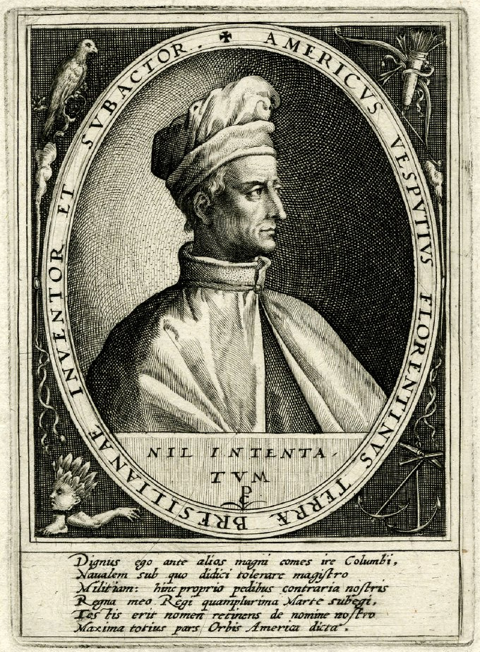 America is named after Italian explorer Amerigo Vespucci.[13] The name "America" was first recorded in 1507. A two-dimensional globe created by Martin Waldseemüller was the earliest recorded use of the term.[14] The name was also used (together with the related term Amerigen) in the Cosmographiae Introductio, apparently written by Matthias Ringmann, in reference to South America.[15] It was applied to both North and South America by Gerardus Mercator in 1538. "America" derives from Americus, the Latin version of Italian explorer Amerigo Vespucci's first name. The feminine form America was originally used to refer to the newly discovered continent, which is why it was accorded with the feminine names of the other continents: Asia, Africa, and Europa.[16] Since the 1950s,[17] however, North America and South America have generally been considered by English speakers as separate continents, and taken together are called the Americas, or more rarely America.[18][19][3] When conceived as a unitary continent, the form is generally the continent of America in the singular. However, without a clarifying context, singular America in English commonly refers to the United States of America.[3] https://en.wikipedia.org/wiki/Americas ++++++++++++++++++++++++++++ Toponimia 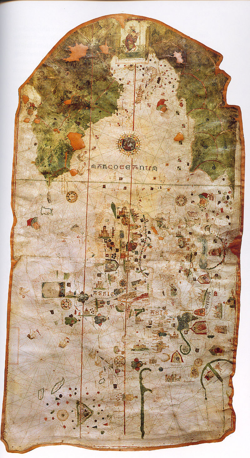 Mapa de Juan de la Cosa (1500), fue el primer Mapamundi que contiene una representación del nuevo continente. 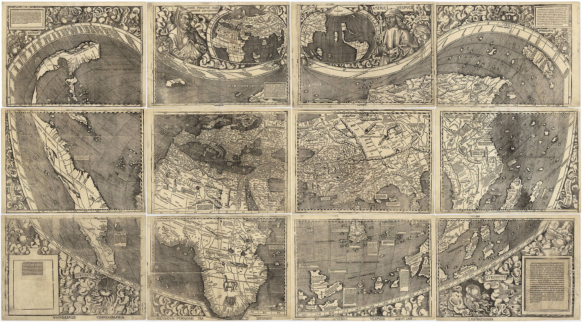 Universalis Cosmographia, de Martín Waldseemüller (1507), fue el primer Mapamundi en denominar «América» a las nuevas tierras descubiertas. El mapa cartografía el océano Pacífico y el istmo centroamericano antes del «descubrimiento» atribuido a Balboa en 1513. El mapa es conocido como el Certificado de Nacimiento de América y se encuentra en la Galería de Tesoros de la Biblioteca del Congreso de los Estados Unidos. En castellano, el macrotopónimo más usado para este continente es América. La forma plural Américas no está desaconsejada por la Asociación de Academias de la Lengua Española.[7] El gentilicio estándar en español es americano. Al respecto, la ASALE, en su «Diccionario panhispánico de dudas», recomienda evitar el uso de «americano» como sinónimo de «estadounidense».[8] El nombre Nuevo Mundo para este continente está actualmente restringido al lenguaje académico, especialmente en materias de historia[9] o biología.[cita requerida] El nombre colonial Indias Occidentales ha pasado a ser desusado para referir a todo el continente, solamente utilizado en textos historiográficos para hablar de ese periodo histórico, aunque algunos lo usan modernamente para referir exclusivamente a las islas del Caribe. Por su parte, algunos movimientos indigenistas o indianistas utilizan en español neologismos adaptados de términos indígenas para llamar al continente, especialmente Abya Yala.[10][11] América Véase también: Americano (palabra) En 1507, por primera vez se utiliza el nombre de «América» en un mapa, tal como descubrió Alexander von Humboldt para denominar lo que hoy se conoce como América del sur en el mapa de Waldseemüller. Generalmente se acepta que el nombre deriva del navegante y cosmógrafo florentino Américo Vespucio (1454-1512), para referirse a las costas de la actual Sudamérica, consideradas como un Nuevo Mundo desconocido por los antiguos. Vespucio, navegante de origen florentino que realizó algún viaje al servicio de España, fue probablemente el primer europeo en sugerir que esas tierras eran en realidad un continente nuevo y no parte de Asia como pensaba Cristóbal Colón. Más tarde Gerardus Mercator en su mapa de 1538 extendería el nombre a todo el continente,[12] y este topónimo se aplicó al resto del continente.[13][14][15] La primera vez que se utilizó el nombre «América» en Europa para designar las tierras a las que llegó Colón fue en un tratado titulado Cosmographiae Introductio, redactado por Mathias Ringmann[16] y otros para acompañar al planisferio mural Universalis Cosmographia, dibujado por el cartógrafo alemán Martín Waldseemüller en Saint-Dié-des-Vosges (noreste de Francia), en dicho mapa el nombre «América» aparecía sobre América del Sur, todavía separada de América del Norte por un estrecho paso interoceánico. Más tarde Gerardus Mercator en su mapa de 1538 extendería el nombre a todo el continente.[12] El continente aparecía rodeado por el mar y perfectamente diferenciado de Asia, con banderas castellanas y leyendas que indicaban que aquellas tierras habían sido descubiertas per mandatum regis Castelle. En el texto se corregían las concepciones ptolemaicas incorporando los descubrimientos de españoles y portugueses, y titulaba al nuevo continente América en honor a Américo Vespucio a quien tanto el tratado como el mapa atribuían el descubrimiento. Siguiendo la línea de los otros continentes con nombre femenino, se latinizó el nombre del explorador y se feminizó, resultando América.[17]Gracias al desarrollo de la imprenta, las denominaciones de Waldseemüller se divulgaron rápidamente en los círculos científicos de Europa.[18][19][20] 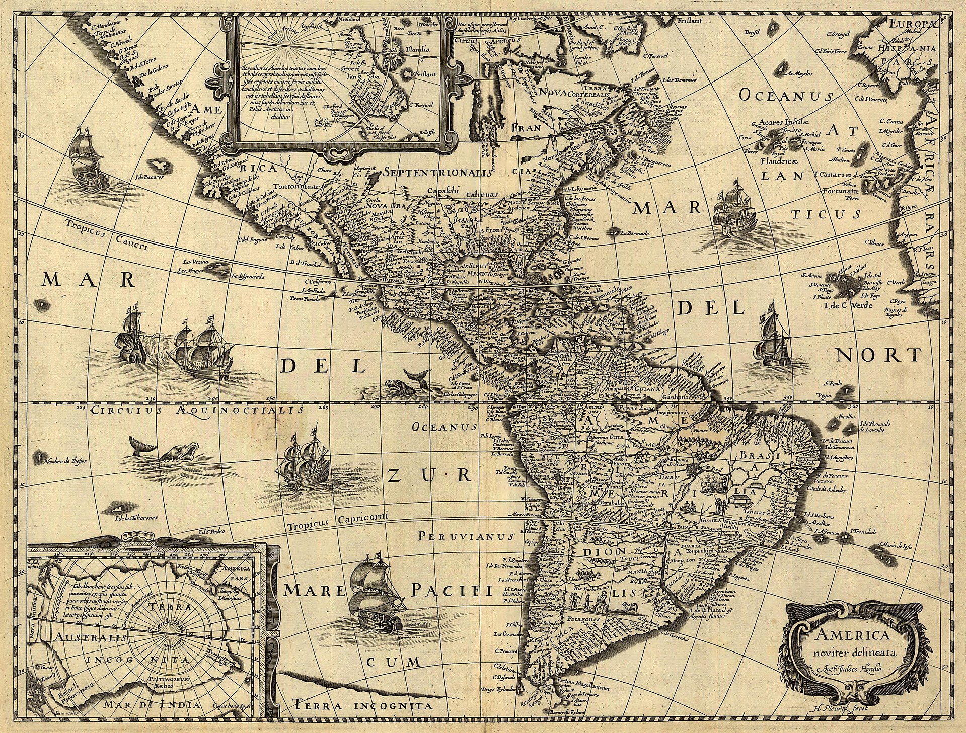 Mapa de América por el cartógrafo Jodocus Hondius, realizado c. 1640 Para referirse a las islas y toda la masa continental del hemisferio occidental, el geógrafo de origen flamenco Gerardus Mercator usó la misma palabra América por primera vez en sus trabajos cartográficos con un mapa del mundo editado en el año 1538. Por otro lado, la Monarquía Española denominó jurídicamente a sus posesiones americanas como Reinos castellanos de Indias. La Corona británica las llamó Indias Occidentales. Etimología de Américo En cuanto al nombre Américo, en italiano Amerigo, es una variante del nombre germánico Emmerich,[21] de etimología incierta. Su segundo lexema ric, «poder», es común a otros nombres y no plantea dudas: El primer elemento puede ser ermen «entero», en este caso sería una forma de Ermenrico, «el poderoso» o bien, amal «trabajo», una variante de Amalarico, «poderoso en su trabajo» o, incluso heim, «hogar», «patria», en cuyo caso es otra forma del nombre Enrique, «el jefe del hogar» (o «de la patria»).[22][23] Otras hipótesis Se han propuesto otros orígenes para el nombre América, pero carecen de evidencia y resultan improbables desde el punto de vista histórico o filológico. Las dos hipótesis más difundidas son que el nombre proviene de un mercader de Bristol, Richard Ap Meryk, o Amerike, es decir «el hijo de Meurig», quien habría financiado el viaje de Juan Caboto, a Terranova en 1497[24][25][26] o de una región llamada Amerrique, originalmente Amerristiquiqque «lugar de viento» en la lengua mayense de la región, ubicada en el interior de la actual Nicaragua,[27] la cual poseía grandes recursos de oro que habrían descubierto tanto Colón como Américo Vespucio, y que incluso este último habría cambiado su nombre en honor a dicha zona ya que dicho nombre no figura en ningún registro antes del año 1500.[28] La creencia de que Richard Amerike fue uno de los principales financiadores del viaje de Caboto se difundió desde finales del siglo xx, sin embargo no existe ninguna evidencia en tal sentido. Por el contrario, la investigación actual no posee un solo dato que lo relacione con el viaje o el barco de Caboto.[29][30][31][32] En cuanto al nombre Amerrisque, parece ser posterior al mapa de Waldseemüller, no habiendo registro del mismo hasta el siglo xix. En otros idiomas En lenguas amerindias Los indígenas americanos carecieron de un nombre para el continente, modernamente se han reivindicado antiguos nombres nativos como denominaciones autóctonas, entre ellos el mencionado Amerrisque en lengua quiché[28] Abya Yala, usado por la etnia Kuna[33] y Cem Ānáhuac por los aztecas.[34] Algunos grupos hispanohablantes, sobre todo vinculados a movimientos pro derechos indígenas, utilizan hoy en día preferentemente Abya Yala por sobre América. En otros idiomas no amerindios Desde el siglo xviii en la literatura y la prensa de habla inglesa, comenzó a ser usado para designar a las Trece Colonias británicas de América y, desde 1776, a los Estados Unidos de América. En inglés es frecuente distinguir entre America, la mencionada nación estadounidense, y The Americas (plural), el continente en su conjunto. Esta distinción ha ido ganando usuarios en otras lenguas del mundo, por calco semántico, incluso en español.[35][36] |
語源と命名 詳細は「アメリカ大陸の命名」を参照 アメリカという名称は、イタリアの探検家アメリゴ・ヴェスプッチに由来する。 アメリカという名称は1507年に初めて記録された。マルティン・ヴァルドゼーミュラーが作成した2次元の地球儀が、この用語の最も古い記録である。 [14] この名称は、マティアス・リングマンが著したとされる『宇宙誌入門』でも(関連用語である「アメリゲン」とともに)南アメリカについて言及されている。 [15] 1538年には、ゲラルドゥス・メルカトルによって南北アメリカ大陸の両方に適用された。「アメリカ」という名称は、イタリア人探検家アメリゴ・ヴェス プッチのファーストネームのラテン語版である「アメリクス」に由来する。 女性形の「アメリカ」は、当初は新しく発見された大陸を指すために使われていた。そのため、他の大陸の女性名である「アジア」、「アフリカ」、「ヨーロッパ」と組み合わされた。 しかし、1950年代以降、英語話者たちは一般的に北アメリカと南アメリカを別々の大陸とみなすようになり、両者を合わせてアメリカ大陸、またはよりまれ にアメリカと呼ぶようになった。[18][19][3] 単一の大陸として考えられる場合、その形は一般的に単数形のアメリカ大陸となる。しかし、明確な文脈がなければ、英語の単数形アメリカは一般的にアメリカ 合衆国を指す。[3] https://en.wikipedia.org/wiki/Americas ++++++++++++++++++++++++++++ 地名学 フアン・デ・ラ・コスタ(1500年)の地図は、新大陸が描かれた最初の世界地図である。 マルティン・ヴァルトゼーミュラー(1507年)の『宇宙誌大全』は、新しく発見された土地を「アメリカ」と名付けた最初の世界地図である。この地図は、 1513年にバルボアによる「発見」に先立つ太平洋と中央アメリカの地峡を描いている。この地図は「アメリカの出生証明書」として知られ、米国議会図書館 の宝物ギャラリーに展示されている。 スペイン語では、この大陸の最も一般的なマクロトポニムは「アメリカ(América)」である。スペイン語アカデミーは、複数形「アメリカス (Américas)」の使用を否定していない。[7] 標準的なスペイン語の呼称は「アメリカ人(americano)」である。この点に関して、ASALEは「汎スペイン語の疑問辞典」の中で、「アメリカ人 (americano)」を「アメリカ人(estadounidense)」の同義語として使用することを避けるよう推奨している。[8] この大陸を「新世界」と呼ぶ名称は、現在では学術的な言語に限定されており、特に歴史学[9]や生物学[要出典]などの分野で使用されている。植民地時代 の名称「インディアス」は、大陸全体を指す名称としては廃れており、歴史学のテキストでその歴史的時代について語る際にのみ使用されているが、今日ではカ リブ海の島々を指すためにのみ使用されることもある。一方、インディオ主義者やインディオ研究者の中には、スペイン語の土着語から借用した新語を、特にア ビャ・ヤラ(Abya Yala)という大陸を指す言葉として使用する者もいる。[10][11] アメリカ 関連項目:アメリカ(言葉) 1507年、アレクサンダー・フォン・フンボルトが発見した地図上で、「アメリカ」という名称が初めて使用された。この地図は、ヴァルトゼーミュラーの地 図上で、現在では南アメリカとして知られている地域を指していた。この名称は、フィレンツェ出身の航海者であり地理学者でもあったアメリゴ・ヴェスプッチ (1454-1512)に由来し、古代の人々には知られていなかった新世界である現在の南米大陸の海岸を指すために使われたというのが一般的な見方であ る。ヴェスプッチはフィレンツェ出身の航海士で、スペインの船で航海した経験があり、おそらく、これらの土地は実際には新しい大陸であり、クリスト ファー・コロンブスが考えていたようなアジアの一部ではないと示唆した最初のヨーロッパ人であった。その後、ゲラルトゥス・メルカトルが1538年の地図 でこの名称を大陸全体に広げ[12]、この地名が大陸の他の地域にも適用されるようになった。[13][14][15] コロンブスが到達した土地を指して「アメリカ」という名称がヨーロッパで初めて使用されたのは、 ドイツの地図製作者マルティン・ヴァルトゼーミュラーがサン=ディエ=デ=ヴォージュ(フランス北東部)で描いた壁画天球儀『ユニバーサリス・コスモグラ フィア』に添えるものとして、マティアス・リングマン(Mathias Ringmann)[16] らによって書かれた論文である。その地図では、「アメリカ」という名称が南アメリカ大陸の上に記されており、北アメリカ大陸とはまだ狭い海洋通路で隔てら れていた。その後、ゲラルトゥス・メルカトルは1538年の地図で、その名称を大陸全体に拡大した。[12] 大陸は海に囲まれているように描かれ、アジアとは完全に区別されていた。カスティーリャの旗と説明文が、それらの土地はカスティーリャ王の命により発見さ れたことを示していた。本文では、プトレマイオス朝の概念はスペインとポルトガルの発見を組み込むことで修正され、新大陸は、その発見を唱えたヴェスプッ チに敬意を表して「アメリカ」と名付けられた。他の大陸が女性名で命名された流れに沿って、探検家の名前はラテン語化され女性形に変更され、アメリカとい う名称が生まれた。[17] 印刷機の開発により、ヴァルトゼーミュラーの名称はヨーロッパの科学界で急速に広まった。[18][19][20] 地図製作者ヨドクス・ホンドゥスによるアメリカ大陸地図(1640年頃作成) フランドル人の地理学者ゲラルドゥス・メルカトルは、1538年に出版された世界地図の地図製作作品で、西半球の島々および大陸全体を指すのに初めて「ア メリカ」という同じ単語を使用した。一方、スペイン王国は、アメリカ領土をカスティーリャ王領インディアスと呼んでいた。また、イギリス王冠領は、それら を西インド諸島と呼んでいた。 アメリゴの語源 イタリア語で「アメリゴ」という名前は、ゲルマン系の名前「エメリック」の変形であり、語源は不明である。2番目の語幹「力」は他の名前にも共通してお り、疑いの余地はない。最初の要素は「全体」を意味する ermen である可能性があり、その場合は「力強い」を意味する Ermenrico、あるいは「仕事ができる」を意味する amal、「仕事ができる」を意味する Amalarico の変形、あるいは「家」、「故郷」を意味する heim、「家長」を意味する Enrique の別の形である可能性もある (または「祖国の」)。[22][23] その他の仮説 アメリカという名前の起源として、その他の説も提案されているが、それらには証拠がなく、歴史的または文献学的な観点から見てもありそうもない。 最も広く信じられている仮説は2つあり、1つはブリストルの商人リチャード・アプ・メリック(Richard Ap Meryk)に由来するという説、もう1つは「Meurigの息子」を意味するAmerikeに由来するという説である。前者は、1497年にジョン・カ ボットがニューファンドランド島への航海に出る際に資金援助をした人物である[24][25][26]。もう1つの説は、Amerriqueと呼ばれる地 域に由来するという説である。この地域は、もともとAmerristiquiqque「風の場所」という意味の 現在のニカラグアの内陸部に位置するマヤ語で「風の地」を意味する地域[27]は、コロンブスとアメリゴ・ヴェスプッチの両者が発見していたであろう豊富 な金鉱床があり、後者については1500年以前の記録にはその地名は登場しないため、その地域に敬意を表して名前を変更していた可能性もある[28]。 リチャード・アメリケがカボットの航海の主要な出資者の一人であったという説は20世紀末から広まったが、それを裏付ける証拠はない。それどころか、現在の研究では、彼とカボットの航海や船とを結びつけるデータは一つもない。[29][30][31][32] アメリスクという名称については、ヴァルトゼーミュラーの地図より後の時代のもので、19世紀まで記録が残っていない。 他の言語では アメリカインディアン諸語では アメリカ大陸に固有の名称を持たなかったアメリカ先住民は、現代になって先住民の名称を復活させている。前述のキチェ語の「アメリスク」[28]、クナ族 が使用する「アビ・ヤラ」[33]、アステカ族の「セム・アンアワック」などである。 [34] スペイン語話者の一部、特に先住民の権利擁護運動に関わる人々は、現在ではアメリカよりもアバイ・ヤラという名称を好んで使用している。 アメリカインディアン以外の言語では 18世紀以降、英語の文学や報道では、アメリカ大陸のイギリス植民地13州を指すために使用され始め、1776年以降はアメリカ合衆国を指すために使用さ れるようになった。英語では、前述のアメリカ合衆国を指す「アメリカ」と、大陸全体を指す「アメリカ大陸」(複数形)を区別することが一般的である。この 区別は、意味を訳した翻訳によって、世界の他の言語のユーザーの間でも広まりつつある。スペイン語でも同様である。[35][36] https://es.wikipedia.org/wiki/Am%C3%A9rica |
| History Main article: Naming of the Americas The region was initially termed America or New India on the Mercator maps.[20]  English Main article: American (word) Speakers of English generally refer to the landmasses of North America and South America as the Americas, the Western Hemisphere, or the New World.[4] The adjective American may be used to indicate something pertaining to the Americas,[2] but this term is primarily used in English to indicate something pertaining to the United States.[2][21][22] Some non-ambiguous alternatives exist, such as the adjective Pan-American,[23] or New Worlder as a demonym for a resident of the closely related New World.[24] Use of America in the hemispherical sense is sometimes retained, or can occur when translated from other languages.[25] For example, the Association of National Olympic Committees (ANOC) in Paris maintains a single continental association for "America", represented by one of the five Olympic rings.[26] American essayist H. L. Mencken said, "The Latin-Americans use Norteamericano in formal writing, but, save in Panama, prefer nicknames in colloquial speech."[27] To avoid "American" one can use constructed terms in their languages derived from "United States" or even "North America".[22][28][29] In Canada, its southern neighbor is often referred to as "the United States", "the U.S.A.", or (informally) "the States", while U.S. citizens are generally referred to as "Americans".[22] Most Canadians resent being referred to as "Americans".[22] Spanish In Spanish, América is a single continent composed of the subcontinents of América del Sur and América del Norte, the land bridge of América Central, and the islands of the Antillas. Americano or americana in Spanish refers to a person from América in a similar way that in which europeo or europea refers to a person from Europa. The terms sudamericano/a, centroamericano/a, antillano/a and norteamericano/a can be used to more specifically refer to the location where a person may live. Citizens of the United States of America are normally referred to by the term estadounidense (rough literal translation: "United Statesian") instead of americano or americana which is discouraged,[30][31] and the country's name itself is officially translated as Estados Unidos de América (United States of America), commonly abbreviated as Estados Unidos (EEUU).[31] Also, the term norteamericano (North American) may refer to a citizen of the United States, though in formal writing it is less common since it is used for the inhabitants of North America.[32] Portuguese In Portuguese, América[33] is a single continent composed of América do Sul (South America), América Central (Central America) and América do Norte (North America).[34] It can be ambiguous, as América can be used to refer to the United States of America, but is avoided in print and formal environments.[35][36] French In French, the word américain may be used for things relating to the Americas; however, similar to English, it is most often used for things relating to the United States, with the term états-unien sometimes used for clarity. Panaméricain may be used as an adjective to refer to the Americas without ambiguity.[37] French speakers may use the noun Amérique to refer to the whole landmass as one continent, or two continents, Amérique du Nord and Amérique du Sud. In French, Amérique is seldom used to refer to the United States, leading to some ambiguity when it is. Similar to English usage, les Amériques or des Amériques is used to refer unambiguously to the Americas. Dutch In Dutch, the word Amerika mostly refers to the United States.[38][39] Although the United States is equally often referred to as de Verenigde Staten ("the United States") or de VS ("the US"), Amerika relatively rarely refers to the Americas, but it is the only commonly used Dutch word for the Americas. This often leads to ambiguity; and to stress that something concerns the Americas as a whole, Dutch uses a combination, namely Noord- en Zuid-Amerika (North and South America). Latin America and Central America are generally referred to as Latijns Amerika and Midden-Amerika respectively. The adjective Amerikaans is most often used for things or people relating to the United States. There are no alternative words to distinguish between things relating to the United States or to the Americas. Dutch uses the local alternative for things relating to elsewhere in the Americas, such as Argentijns for Argentine, etc. |
歴史 詳細は「アメリカ大陸の命名」を参照 この地域は、メルカトルの地図では当初「アメリカ」または「ニュー・インディア」と呼ばれていた。 英語 詳細は「アメリカン(語)」を参照 英語話者は一般的に、北アメリカと南アメリカの陸地をアメリカ大陸、西半球、または新世界と呼ぶ。 [4] 形容詞のアメリカン(American)はアメリカ大陸に関するものを指すために使われることがあるが[2]、この用語は主に英語でアメリカ合衆国に関す るものを指すために使われる。[2][21][22] 曖昧さを排除した代替案としては、形容詞のパンアメリカン(Pan-American)[23]や、密接に関連する新世界に居住する人々を示すニューワル ダー(New Worlder)などがある。 [24] アメリカ大陸という意味でのアメリカという語は、時折使用され続けているし、他の言語から翻訳される際にも使用されることがある。[25] 例えば、パリにある国内オリンピック委員会連合(ANOC)は、5つのオリンピックリングのうちの1つで表される「アメリカ」のための単一の大陸協会を維 持している。[26] アメリカの随筆家H. L. メンケンは、「ラテンアメリカ人は公式の文章では Norteamericano という表現を用いるが、パナマを除いては口語ではあだ名を好む」と述べている。[27] 「アメリカ」という表現を避けるために、「アメリカ合衆国」や「北アメリカ」に由来するその言語で造語された用語を用いることもできる。 [22][28][29] カナダでは、南の隣国を「the United States」、「the U.S.A.」、または(非公式に)「the States」と呼ぶことが多いが、米国市民は一般的に「Americans」と呼ばれる。[22] カナダ人の大半は「Americans」と呼ばれることを嫌がる。[22] スペイン語 スペイン語では、アメリカ(América)は、南アメリカ(América del Sur)と北アメリカ(América del Norte)の亜大陸、アメリカ中央部の地峡、アンティル諸島からなる単一の大陸である。スペイン語でアメリカ人(americanoまたは americana)は、ヨーロッパ人(euroamericanoまたはeuropeana)がヨーロッパ出身の人を指すのと同様に、アメリカ出身の人 を指す。sudamericano/a、centroamericano/a、antillano/a、norteamericano/aという用語は、 その人格が居住している場所をより具体的に示すために使用することができる。 アメリカ合衆国の市民は通常、アメリカ人(アメリカ人)というよりも、アメリカステアーノ(アメリカ人)という言葉で呼ばれる。これは直訳すると「アメリ カ人」となるが、アメリカ人という言葉は推奨されていない。また、この国の名称自体は、公式には「Estados Unidos de América(アメリカ合衆国)」と訳され、通常は「Estados Unidos(EEUU)」と略される。 [31] また、norteamericano(北米人)という用語は、米国市民を指すこともあるが、公式な文書ではあまり一般的ではなく、北米の住民に対して使用 されるためである。[32] ポルトガル語 ポルトガル語では、América[33]は、América do Sul(南アメリカ)、América Central(中央アメリカ)、América do Norte(北アメリカ)からなる単一の大陸である。[34] Américaはアメリカ合衆国を指す場合もあるため、曖昧である可能性があるが、印刷物や公式の場では避けられている。[35][36] フランス語 フランス語では、アメリカ大陸に関連するものに対して「アメリカ人」という意味の「américain」という語が使われることがあるが、英語と同様に、 アメリカ合衆国に関連するものに対して最もよく使われる。明確にするために「états-unien」という語が使われることもある。 Panaméricainは、アメリカ大陸を指す形容詞として使用されることもある。[37] フランス語話者は、アメリカ大陸全体をひとつの大陸、または北アメリカと南アメリカというふたつの大陸として指すために、名詞のAmériqueを使用す ることがある。フランス語では、アメリカ合衆国を指してAmériqueが使用されることはまれであり、使用される場合は曖昧さを伴う。英語と同様に、 les Amériquesまたはdes Amériquesは、アメリカ大陸を指す際に使用される。 オランダ語 オランダ語では、Amerikaという単語は主にアメリカ合衆国を指す。[38][39] アメリカ合衆国は、de Verenigde Staten(「合衆国」)またはde VS(「米国」)と呼ばれることも同程度にあるが、Amerikaが南北アメリカ大陸を指すことは比較的まれである。しかし、これは南北アメリカ大陸を指 すオランダ語として一般的に使用される唯一の単語である。このため、しばしば曖昧な表現となる。アメリカ大陸全体を指す場合は、オランダ語ではNoord - en Zuid-Amerika(北米および南米)という組み合わせが使用される。 中南米はそれぞれ、Latijns Amerika(ラテンアメリカ)および Midden-Amerika(中央アメリカ)と呼ばれる。 形容詞のAmerikaansは、米国に関連する物事や人に対して最もよく使用される。米国または米州に関連する物事を区別する代替語はない。オランダ語 では、アルゼンチンに関連する物事に対してはArgentijnsなど、米州の他の地域に関連する物事に対しては現地の代替語を使用する。 |
| History Main article: History of the Americas Pre-Columbian era Main article: Pre-Columbian era 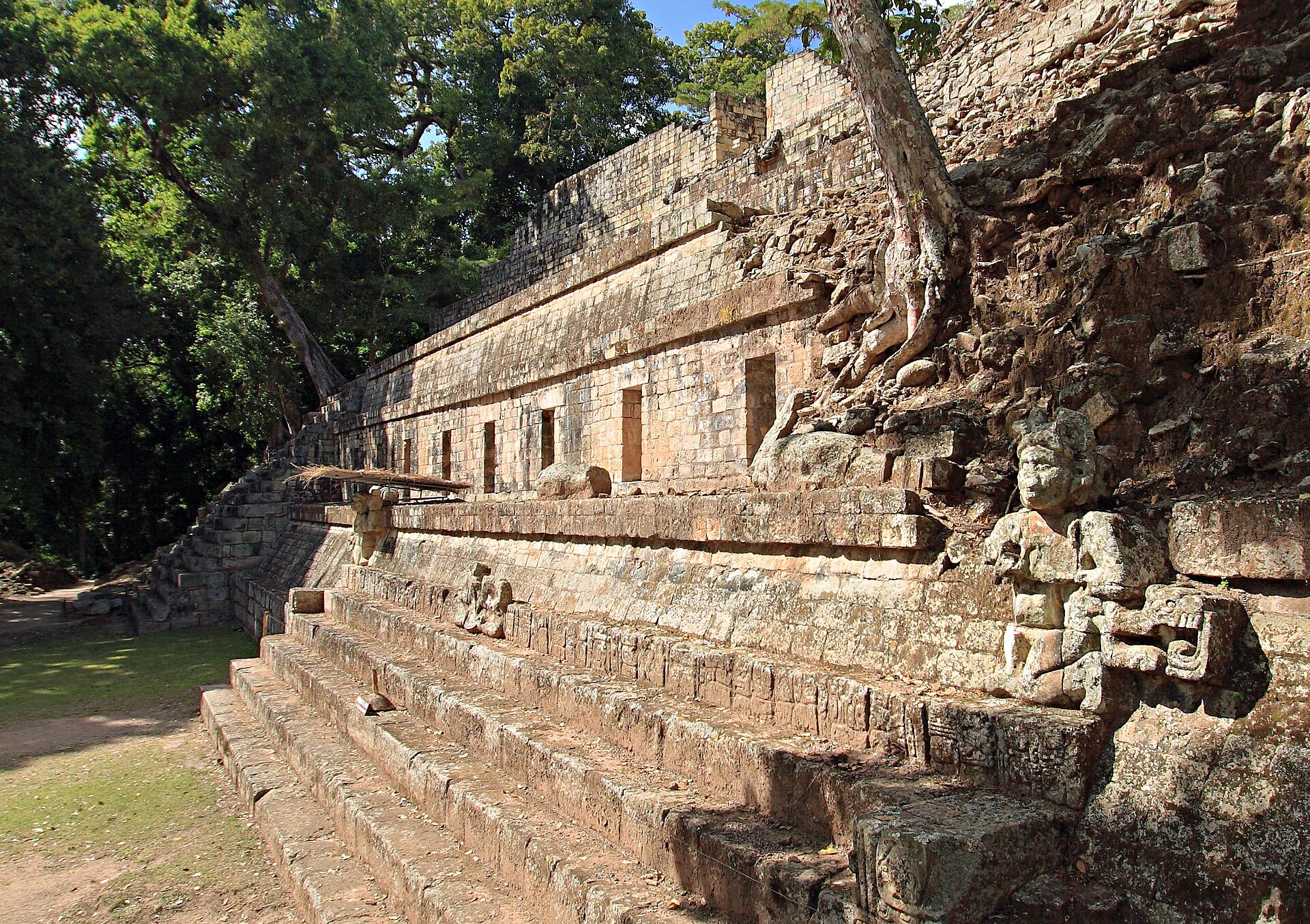 The Plaza Occidental in Copán, Honduras The pre-Columbian era incorporates all period subdivisions in the history and prehistory of the Americas before the appearance of significant European influences on the American continents, spanning the time of the original settlement in the Upper Paleolithic to European colonization during the Early Modern period. The term Pre-Columbian is used especially often in the context of the great indigenous civilizations of the Americas, such as those of Mesoamerica (Olmec, Toltec, Teotihuacano, Zapotec, Mixtec, Aztec, Maya) and the Andean civilizations (Inca, Moche, Chavín, Muisca, Cañari). Many pre-Columbian civilizations established characteristics and hallmarks which included permanent or urban settlements, agriculture, civic and monumental architecture, and complex societal hierarchies. Some of these civilizations had long faded by the time of the first permanent European arrivals (c. late 15th–early 16th centuries), and are known only through archeological investigations. Others were contemporary with this period, and are also known from historical accounts of the time. A few, such as the Maya, had their own written records. However, most Europeans of the time viewed such texts as pagan, and much was destroyed in Christian pyres. Only a few hidden documents remain today, leaving modern historians with glimpses of ancient culture and knowledge.[40] Settlement Further information on theories of Paleo-Indian migration: Peopling of the Americas 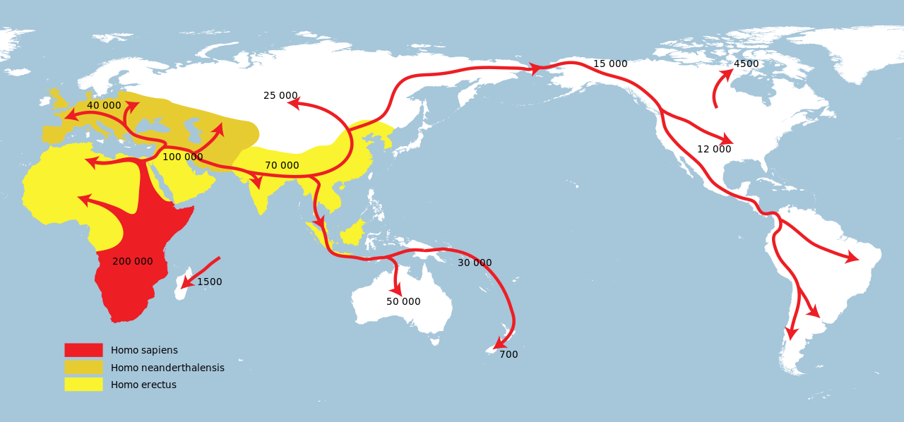 Map of early human migrations based on the Out of Africa theory[41] The first inhabitants migrated into the Americas from Asia. Habitation sites are known in Alaska and Yukon from at least 20,000 years ago, with suggested ages of up to 40,000 years.[42][43][44] Beyond that, the specifics of the Paleo-Indian migration to and throughout the Americas, including the dates and routes traveled, are subject to ongoing research and discussion.[45] Widespread habitation of the Americas occurred after the Late Glacial Maximum, from 16,000 to 13,000 years ago.[44][46] |
歴史 詳細は「アメリカ大陸の歴史」を参照 コロンブス到来以前 詳細は「コロンブス到来以前」を参照 ホンジュラス、コパンのオクシデンタル広場 コロンブス到来以前の時代は、アメリカ大陸にヨーロッパからの大きな影響が現れる前のアメリカ大陸の歴史および先史時代におけるすべての時代区分を含み、 旧石器時代の初期の定住から近世におけるヨーロッパの植民地化までの期間にわたる。コロンブス到来以前という用語は、特にアメリカ大陸の先住民族の偉大な 文明、例えばメソアメリカ(オルメカ、トルテカ、テオティワカン、サポテカ、ミシュテカ、アステカ、マヤ)やアンデス文明(インカ、モチェ、チャビン、ム イスカ、カナリ)などの文脈で頻繁に使用される。 多くのコロンブス到来以前の文明は、恒久的または都市的な定住地、農業、公共建築や記念建造物、複雑な社会階層などの特徴や印を確立した。これらの文明の 一部は、ヨーロッパ人が初めて恒久的に到着した時点(15世紀後半から16世紀初頭)までにすでに衰退しており、考古学調査を通じてのみ知られている。こ の時代とほぼ同時代に存在した文明は、当時の歴史的記録から知ることができる。マヤ文明のように、独自の文字記録を残した文明もいくつかある。しかし、当 時のヨーロッパ人の大半は、このような文字を異教徒のものと見なし、キリスト教の焚書によって多くが破壊された。今日まで残っているのはごく一部の隠され た文書だけであり、現代の歴史家は古代の文化や知識の断片を垣間見ることができるに過ぎない。 定住 旧石器時代のインディアンの移動に関する理論の詳細:アメリカ大陸への人類の拡散 アフリカ単一起源説に基づく初期の人類の移動の地図[41] 最初の居住者はアジアからアメリカ大陸へと移動した。少なくとも2万年前から、アラスカとユーコンには居住跡が知られており、最古のものでは4万年前まで さかのぼる可能性もある。 [42][43][44] それ以前の旧石器時代のアメリカ大陸への移住については、年代や移動ルートなど、詳細については現在も研究と議論が続けられている。[45] アメリカ大陸への広範な定住は、最終氷期最盛期(1万6000年から1万3000年前)以降に起こった。[44][46] |
 Statue representing the Americas at Palazzo Ferreria, in Valletta, Malta The traditional theory has been that these early migrants moved into the Beringia land bridge between eastern Siberia and present-day Alaska around 40,000–17,000 years ago,[47] when sea levels were significantly lowered during the Quaternary glaciation.[45][48] These people are believed to have followed herds of now-extinct pleistocene megafauna along ice-free corridors that stretched between the Laurentide and Cordilleran ice sheets.[49] Another route proposed is that, either on foot or using primitive boats, they migrated down the Pacific coast to South America.[50] Evidence of the latter would since have been covered by a sea level rise of hundreds of meters following the last ice age.[51] Both routes may have been taken, although the genetic evidences suggests a single founding population.[52] The micro-satellite diversity and distributions specific to South American Indigenous peoples indicates that certain populations have been isolated since the initial colonization of the region.[53] A second migration occurred after the initial peopling of the Americas;[54] Na Dene speakers, found predominantly in North American groups at varying genetic rates, with the highest frequency found among the Athabaskans at 42%, derive from this second wave.[55] Linguists and biologists have reached a similar conclusion based on analysis of Amerindian language groups and ABO blood group system distributions.[54][56][57][58] Then the people of the Arctic small tool tradition, a broad cultural entity that developed along the Alaska Peninsula, around Bristol Bay, and on the eastern shores of the Bering Strait c. 2500 BCE, moved into North America.[59] The Arctic small tool tradition, a Paleo-Eskimo culture, branched off into two cultural variants, including the Pre-Dorset and the Independence traditions of Greenland.[60] The descendants of the Pre-Dorset cultural group, the Dorset culture, were displaced by the final migrants from the Bering sea coast line, the Thule people (the ancestors of modern Inuit), by 1000 CE.[60] |
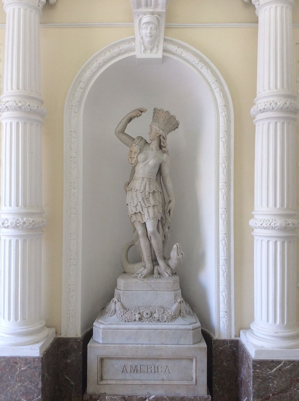
マルタの首都ヴァレッタにあるパラッツォ・フェレリアに展示されているアメリカ大陸を表す像 従来の説では、これらの初期の移住者は、約4万~1万7000年前に、現在のシベリア東部とアラスカの間のベーリング地峡に移住したとされている。 [45][48] これらの人々は、ローレンタイデ氷床とコルディレラ氷床の間に広がっていた氷のない回廊を、現在では絶滅している更新世の大型動物の群畜を追って移動した と考えられている。[49] 別のルートとして、徒歩または原始的な船を使って、太平洋沿岸を南米まで移動したという説も提案されている。 [50] 後者の証拠は、最終氷河期以降の海面の上昇により、数百メートルも水没した可能性がある。[51] 両方のルートが取られた可能性もあるが、遺伝学的証拠は単一の創始者集団を示唆している。[52] 南米の先住民に特有のマイクロサテライトの多様性と分布は、この地域の初期の入植以来、特定の集団が孤立してきたことを示している。[53] アメリカ大陸への最初の入植の後に、2度目の移住が起こった。[54] 北米のグループに主にみられるナ・デネ語族の話者は、遺伝率は様々であるが、アサバスカン族に最も多く、その割合は42%である。彼らはこの2度目の波に 由来する。言語学者や生物学者は、アメリカインディアンの言語グループやABO血液型分布の分析に基づいて、同様の結論に達している。 [54][56][57][58] その後、紀元前2500年頃にアラスカ半島、ブリストル湾周辺、ベーリング海峡東岸で発展した広範な文化体である「北極小形器伝統」の人々が北米大陸に移 住した。 [59] 北極小工具伝統、旧エスキモー文化は、グリーンランドのプレドーセット文化とインディペンデンス文化を含む2つの文化に分岐した。[60] プレドーセット文化の末裔であるドーセット文化は、西暦1000年までに、ベーリング海沿岸からやってきた最後の移住者、トゥーレ族(現代のイヌイットの 祖先)によって追い払われた。[60] |
| Norse colonization Main article: Norse colonization of North America Around the same time as the Inuit migrated into Greenland, Viking settlers began arriving in Greenland in 982 and Vinland shortly thereafter, establishing a settlement at L'Anse aux Meadows, near the northernmost tip of Newfoundland.[61] Contact between the Norse colonies and Europe was maintained, as James Watson Curran states: From 985 to 1410, Greenland was in touch with the world. Then silence. In 1492 the Vatican noted that no news of that country "at the end of the world" had been received for 80 years, and the bishopric of the colony was offered to a certain ecclesiastic if he would go and "restore Christianity" there. He didn't go.[62] |
北欧人の植民地化 詳細は「北欧人の北アメリカ植民地化」を参照 イヌイットがグリーンランドに移住したのとほぼ同時期に、982年にバイキングの入植者がグリーンランドに到着し、その後まもなくヴィンランドにも到着し た。彼らはニューファンドランド島最北端近くのランス・オ・メドウズに定住地を築いた。[61] 北欧人の植民地とヨーロッパとの接触は維持されていた。ジェームズ・ワトソン・カランは次のように述べている。 985年から1410年にかけて、グリーンランドは世界と接触していた。その後、沈黙が続いた。1492年、バチカンは「世界の果てにある」その国からの ニュースが80年間届いていないことに言及し、その植民地の司教職を、そこに行って「キリスト教を復興」する意思のある特定の聖職者に提供した。しかし、 彼はそこへは行かなかった。[62] |
| Large-scale European colonization Main article: European colonization of the Americas 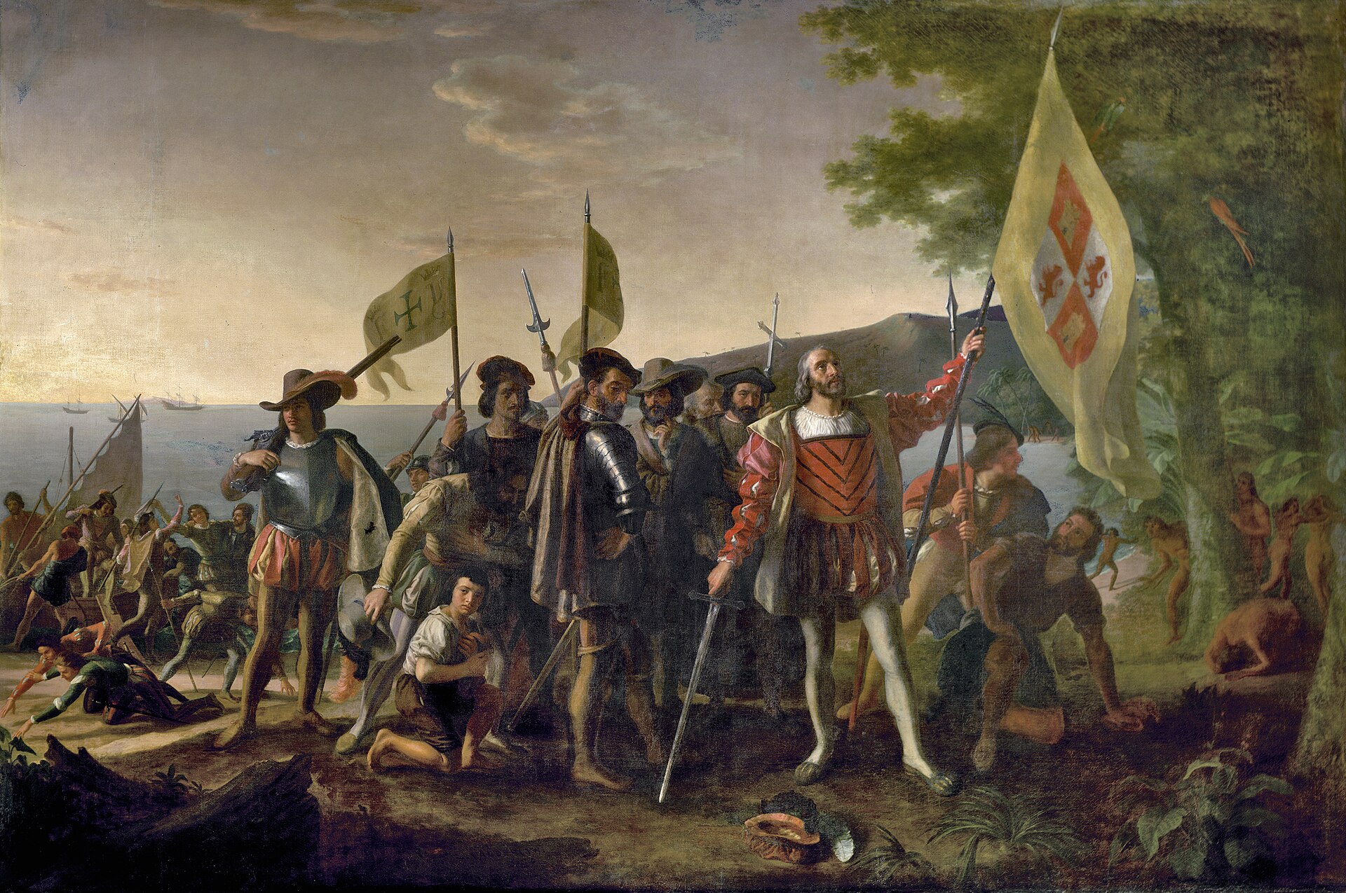 Christopher Columbus leads expedition to the New World, 1492. Although there had been previous trans-oceanic contact, large-scale European colonization of the Americas began with the first voyage of Christopher Columbus in 1492. The first Spanish settlement in the Americas was La Isabela in northern Hispaniola. This town was abandoned shortly after in favor of Santo Domingo de Guzmán, founded in 1496, the oldest American city of European foundation. This was the base from which the Spanish monarchy administered its new colonies and their expansion. Santo Domingo was subject to frequent raids by English and French pirates. On the continent, Panama City on the Pacific coast of Central America, founded on August 15, 1519, played an important role, being the base for the Spanish conquest of South America. Conquistador Lucas Vázquez de Ayllón established San Miguel de Guadalupe, the first European settlement in what is now the United States, on the Pee Dee River in South Carolina.[63] During the first half of the 16th century, Spanish colonists conducted raids throughout the Caribbean Basin, bringing captives from Central America, northern South America, and Florida back to Hispaniola and other Spanish settlements.[64] France, led by Jacques Cartier and Giovanni da Verrazzano,[65] focused primarily on North America. English explorations of the Americas were led by Giovanni Caboto[66] and Sir Walter Raleigh. The Dutch in New Netherland confined their operations to Manhattan Island, Long Island, the Hudson River Valley, and what later became New Jersey. The spread of new diseases brought by Europeans and African slaves killed many of the inhabitants of North America and South America,[67][68] with a general population crash of Native Americans occurring in the mid-16th century, often well ahead of European contact.[69] One of the most devastating diseases was smallpox.[70] European immigrants were often part of state-sponsored attempts to found colonies in the Americas. Migration continued as people moved to the Americas fleeing religious persecution or seeking economic opportunities. Millions of individuals were forcibly transported to the Americas as slaves, prisoners or indentured servants. |
ヨーロッパによる大規模な植民地化 詳細は「ヨーロッパによるアメリカ大陸の植民地化」を参照 1492年、クリストファー・コロンブスが新大陸への遠征を指揮する。 それ以前にも海を越えた接触はあったが、ヨーロッパによるアメリカ大陸への大規模な植民地化は、1492年のクリストファー・コロンブスの最初の航海から 始まった。アメリカ大陸における最初のスペイン人の入植地は、イスパニョーラ島北部のラ・イサベラであった。この町は間もなく放棄され、1496年に創設 されたサントドミンゴ・デ・グスマンが、ヨーロッパ人によるアメリカ最古の都市となった。ここはスペイン王政が新植民地とその拡大を管理する拠点となっ た。サント・ドミンゴは、イングランドやフランスの海賊による襲撃を頻繁に受けた。 大陸では、1519年8月15日に建設された中米の太平洋岸にあるパナマシティが重要な役割を果たし、スペインによる南米征服の拠点となった。コンキスタ ドールのルーカス・バスケス・デ・アヨヨンは、現在のアメリカ合衆国における最初のヨーロッパ人入植地であるサン・ミゲル・デ・グアダルーペを、サウスカ ロライナ州のピードー川沿いに建設した。[63] 16世紀前半には、スペイン人入植者たちがカリブ海全域で略奪行為を行い、中央アメリカ、南アメリカ北部、フロリダから捕虜をイスパニョーラ島やその他の スペイン人入植地に連れ帰った。[64] フランスはジャック・カルティエとジョヴァンニ・ダ・ヴェラッツァーノに率いられ、主に北アメリカに焦点を当てた。[65] アメリカ大陸のイギリスによる探検はジョヴァンニ・カボットとウォルター・ローリー卿に率いられた。ニューネーデルラントのオランダ人はマンハッタン島、 ロングアイランド、ハドソン川流域、後にニュージャージーとなる地域に活動を限定した。ヨーロッパ人とアフリカ人奴隷が持ち込んだ新しい病気の蔓延によ り、北米と南米の住民の多くが死亡し[67][68]、16世紀半ばにはアメリカ先住民の人口が大幅に減少した。この人口減少は、ヨーロッパ人との接触に 先立ってしばしば発生していた[69]。最も壊滅的な病気の一つは天然痘であった[70]。 ヨーロッパからの移民は、国家が支援するアメリカ大陸への植民地建設計画の一環であることが多かった。宗教的迫害から逃れたり、経済的な機会を求めて、人 々はアメリカ大陸へと移住を続けた。何百万人もの人々が、奴隷、囚人、年季奉公人として強制的にアメリカ大陸へと連れて行かれた。 |
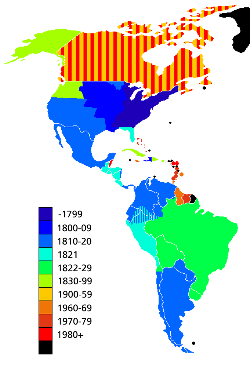 Map showing the dates of independence from European powers. Black signifies areas that are dependent territories or parts of countries with a capital outside the Americas. Decolonization of the Americas began with the American Revolution and the Haitian Revolution in the late 1700s. This was followed by numerous Latin American wars of independence in the early 1800s. Between 1811 and 1825, Paraguay, Argentina, Chile, Gran Colombia, the United Provinces of Central America, Mexico, Brazil, Peru, and Bolivia gained independence from Spain and Portugal in armed revolutions. After the Dominican Republic won independence from Haiti, it was re-annexed by Spain in 1861, but reclaimed its independence in 1865 at the conclusion of the Dominican Restoration War. The last violent episode of decolonization was the Cuban War of Independence which became the Spanish–American War, which resulted in the independence of Cuba in 1898, and the transfer of sovereignty over Puerto Rico from Spain to the United States. Peaceful decolonization began with the United States's purchase of Louisiana from France in 1803, Florida from Spain in 1819, of Alaska from Russia in 1867, and the Danish West Indies from Denmark in 1916. Canada became independent of the United Kingdom, starting with the Balfour Declaration of 1926, Statute of Westminster 1931, and ending with the patriation of the Canadian Constitution in 1982. The Dominion of Newfoundland similarly achieved independence under the Balfour Declaration and Statute of Westminster, but relinquished self-rule in 1934.[71] It was subsequently confederated with Canada in 1949. The remaining European colonies in the Caribbean began to achieve peaceful independence well after World War II. Jamaica and Trinidad and Tobago became independent in 1962, and Guyana and Barbados both achieved independence in 1966. In the 1970s, the Bahamas, Grenada, Dominica, St. Lucia, and St. Vincent and the Grenadines all became independent of the United Kingdom, and Suriname became independent of the Netherlands. Belize, Antigua and Barbuda, and Saint Kitts and Nevis achieved independence from the United Kingdom in the 1980s. |
ヨーロッパ諸国からの独立年を示す地図。黒は、属領または首都がアメリカ州域外にある国の一部である地域を示す。 アメリカ大陸の脱植民地化は、1700年代後半のアメリカ独立革命とハイチ革命から始まった。 これに続き、1800年代初頭にはラテンアメリカで多数の独立戦争が勃発した。 1811年から1825年にかけて、パラグアイ、アルゼンチン、チリ、グラン・コロンビア、中央アメリカ連合国、メキシコ、ブラジル、ペルー、ボリビアが スペインとポルトガルから武力革命によって独立を勝ち取った。ドミニカ共和国がハイチから独立した後、1861年にスペインに再併合されたが、ドミニカ回 復戦争の終結により1865年に再び独立を回復した。植民地化の最後の暴力的なエピソードは、キューバ独立戦争であり、これは米西戦争へと発展し、 1898年にキューバが独立し、プエルトリコの主権がスペインからアメリカ合衆国へと移譲された。 平和的な脱植民地化は、1803年のアメリカによるフランスからのルイジアナ購入、1819年のスペインからのフロリダ購入、1867年のロシアからのア ラスカ購入、1916年のデンマークからのデンマーク領西インド諸島購入から始まった。カナダは1926年のバルフォア宣言、1931年のウェストミンス ター憲章を経て、1982年のカナダ憲法の帰属によりイギリスから独立した。ニューファンドランド連邦も同様にバルフォア宣言とウェストミンスター憲章に より独立を達成したが、1934年に自治権を放棄した。[71] その後、1949年にカナダと合併した。 カリブ海に残るヨーロッパの植民地は、第二次世界大戦後しばらくして平和裏に独立を果たし始めた。ジャマイカとトリニダード・トバゴは1962年に、ガイ アナとバルバドスは1966年にそれぞれ独立した。1970年代には、バハマ、グレナダ、ドミニカ、セントルシア、セントビンセント・グレナディーンがイ ギリスから独立し、スリナムがオランダから独立した。ベリーズ、アンティグア・バーブーダ、セントクリストファー・ネイビスは1980年代にイギリスから 独立した。 |
| Geography Further information: Geography of North America and Geography of South America 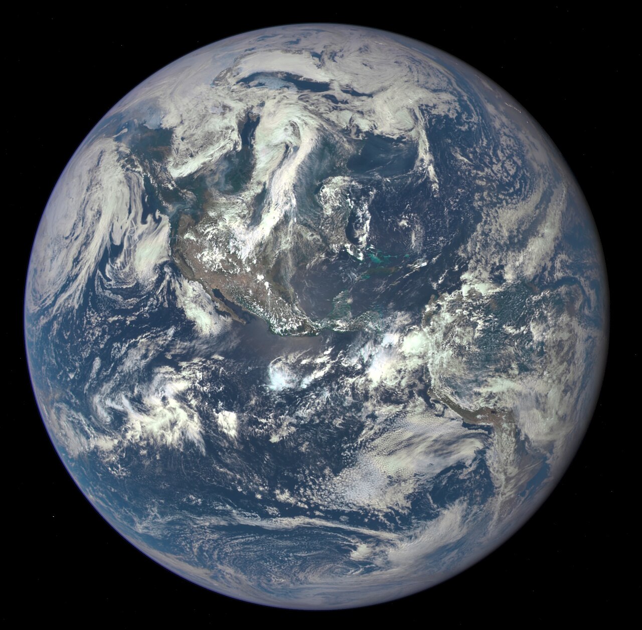 Satellite photo of the Americas on Earth Extent The Americas make up most of the land in Earth's Western Hemisphere.[72] The northernmost point of the Americas is Kaffeklubben Island, which is the most northerly point of land on Earth.[73] The southernmost undisputed point is Águila Islet, although the Antarctic islands of Southern Thule are sometimes taken into account.[74][75] The mainland of the Americas is the world's longest north-to-south landmass. The distance between its two polar extremities, Murchison Promontory on the Boothia Peninsula in northern Canada and Cape Froward in Chilean Patagonia, is roughly 14,000 km (8,700 mi).[76] The mainland's most westerly point is the end of the Seward Peninsula in Alaska; Attu Island, further off the Alaskan coast to the west, is considered the westernmost point of the Americas. Ponta do Seixas in northeastern Brazil forms the easternmost extremity of the mainland,[76] while Nordostrundingen, in Greenland, is the most easterly point of the continental shelf. Geology South America broke off from the west of the supercontinent Gondwana around 135 million years ago, forming its own continent.[77] Around 15 million years ago, the collision of the Caribbean Plate and the Pacific Plate resulted in the emergence of a series of volcanoes along the border that created a number of islands. The gaps in the archipelago of Central America filled in with material eroded off North America and South America, plus new land created by continued volcanism. By three million years ago, the continents of North America and South America were linked by the Isthmus of Panama, thereby forming the single landmass of the Americas.[78] The Great American Interchange resulted in many species being spread across the Americas, such as the cougar, porcupine, opossums, armadillos, and hummingbirds.[79] |
地理 さらに詳しい情報:北アメリカの地理および南アメリカの地理 地球上のアメリカ大陸の衛星写真 範囲 南北アメリカ大陸は地球の西半球の大半の陸地を占めている。[72] 南北アメリカ大陸の最北端は、地球上の陸地としては最北端であるスヴァールバル諸島のスヴァールバル島である。[73] 議論の余地のない最南端はアギラ岩島であるが、南極のサザン・スール諸島が考慮されることもある。 [74][75] アメリカ本土は南北方向に世界最長の陸地である。その両極端の地点、すなわちカナダ北部のブーディア半島にあるマーチソン岬とチリのパタゴニアにあるフロ ワード岬との距離は、およそ14,000km(8,700マイル)である。 [76] 大陸本土の最西端はアラスカのセワード半島先端部であり、アラスカの西海岸からさらに離れたアッツ島はアメリカ大陸の最西端とされている。ブラジル北東部 のポンタ・ド・セイシャス岬は本土の最東端であり、[76] グリーンランドのノードストルンディンゲンは大陸棚の最東端である。 地質 南アメリカは約1億3500万年前に超大陸ゴンドワナの西側から分離し、独自の超大陸を形成した。[77] 約1500万年前、カリブ海プレートと太平洋プレートの衝突により、国境沿いに火山が次々と出現し、多くの島々が誕生した。中央アメリカの列島の隙間は、 北アメリカと南アメリカから浸食された物質で埋められ、さらに継続的な火山活動によって新たな土地が形成された。300万年前までに、北アメリカと南アメ リカはパナマ地峡でつながり、それによってアメリカ大陸という単一の陸塊が形成された。[78] グレート・アメリカン・インターチェンジにより、ピューマ、ヤマアラシ、オポッサム、アルマジロ、ハチドリなど、多くの種がアメリカ大陸全体に広がった。 [79] |
Topography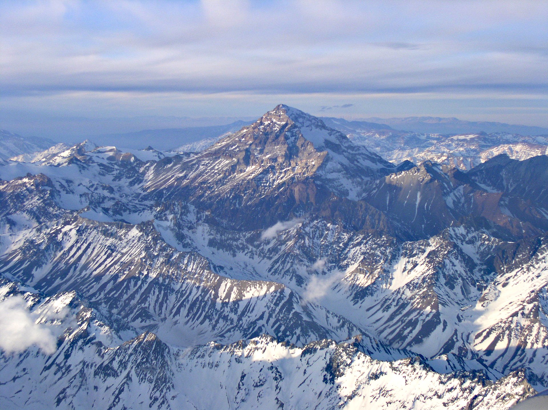 Aconcagua, in Argentina, is the highest peak in the Americas. The geography of the western Americas is dominated by the American Cordillera, with the Andes running along the west coast of South America[80] and the Rocky Mountains and other North American Cordillera ranges running along the western side of North America.[81] The 2,300-kilometer-long (1,400 mi) Appalachian Mountains run along the east coast of North America from Alabama to Newfoundland.[82] North of the Appalachians, the Arctic Cordillera runs along the eastern coast of Canada.[83] The largest mountain ranges are the Andes and Rocky Mountains. The Sierra Nevada and the Cascade Range reach similar altitudes as the Rocky Mountains, but are significantly smaller. In North America, the greatest number of fourteeners are in the United States, and more specifically in the US state of Colorado. The highest peaks of the Americas are located in the Andes, with Aconcagua of Argentina being the highest; in North America Denali (Mount McKinley) in the US state of Alaska is the tallest. Between its coastal mountain ranges, North America has vast flat areas. The Interior Plains spread over much of the continent, with low relief.[84] The Canadian Shield covers almost 5 million km2 of North America and is generally quite flat.[85] Similarly, the north-east of South America is covered by the flat Amazon basin.[86] The Brazilian Highlands on the east coast are fairly smooth but show some variations in landform, while farther south the Gran Chaco and Pampas are broad lowlands.[87] Climate 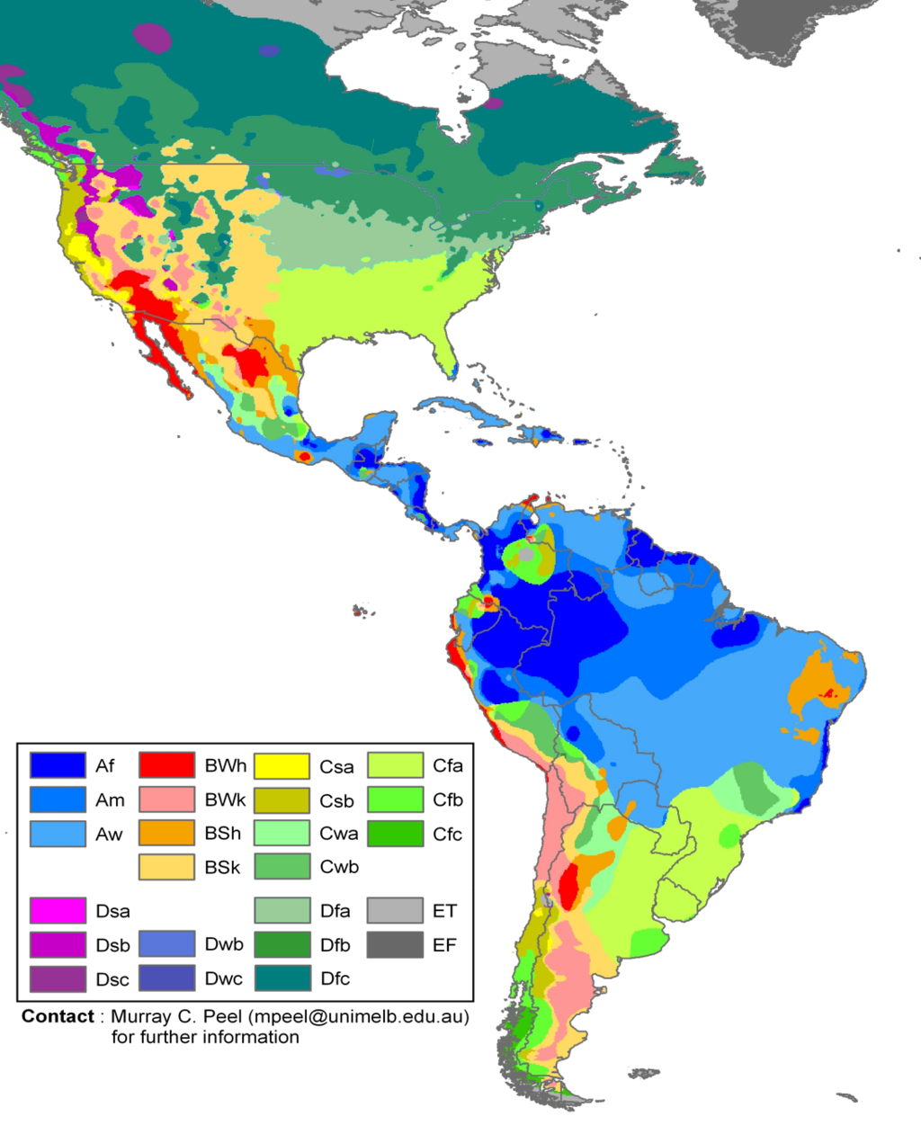 Climate zones of the Americas in the Köppen climate classification system The climate of the Americas varies significantly from region to region. Tropical rainforest climate occurs in the latitudes of the Amazon, American cloud forests, southeastern Florida and Darién Gap. In the Rocky Mountains and Andes, dry and continental climates are observed. Often the higher altitudes of these mountains are snow-capped. Southeastern North America is well known for its occurrence of tornadoes and hurricanes, of which the vast majority of tornadoes occur in the United States' Tornado Alley,[88] as well as in the southerly Dixie Alley in the North American late-winter and early spring seasons. Often parts of the Caribbean are exposed to the violent effects of hurricanes. These weather systems are formed by the collision of dry, cool air from Canada and wet, warm air from the Atlantic. Hydrology With coastal mountains and interior plains, the Americas have several large river basins that drain the continents. The largest river basin in North America is that of the Mississippi, covering the second-largest watershed on the planet.[89] The Mississippi–Missouri river system drains most of 31 states of the United States, most of the Great Plains, and large areas between the Rocky and Appalachian mountains. The Mississippi–Missouri is the fourth-longest river system and has the tenth-greatest discharge in the world. In North America, to the east of the Appalachian Mountains, there are no major rivers but rather a series of rivers and streams that flow east with their terminus in the Atlantic Ocean, such as the Hudson, Saint John, and Savannah rivers. A similar instance arises with central Canadian rivers that drain into Hudson Bay; the largest being the Churchill River. On the west coast of North America, the main rivers are the Colorado, Columbia, Yukon, Fraser, and Sacramento rivers. The Colorado River drains much of the Southern Rockies and parts of the Basin and Range Province. The river flows approximately 1,450 miles (2,330 km) into the Gulf of California,[90] during which over time it has carved out natural phenomena such as the Grand Canyon and created phenomena such as the Salton Sea. The Columbia is a large river, 1,243 miles (2,000 km) long, in central western North America and is the most powerful river on the West Coast of the Americas. In the far northwest of North America, the Yukon drains much of the Alaskan peninsula and flows 1,980 miles (3,190 km)[91] from parts of Yukon and the Northwest Territory to the Pacific. Draining to the Arctic Ocean of Canada, the Mackenzie River drains waters from the Arctic Great Lakes of Arctic Canada, as opposed to the St Lawrence River that drains the Great Lakes of southern Canada into the Atlantic Ocean. The Mackenzie River is the largest in Canada and drains 1,805,200 km2 (697,000 sq mi).[92] The largest river basin in South America is that of the Amazon, which has the highest volume flow of any river on Earth.[93] The second largest watershed of South America is that of the Paraná River, which covers about 2,582,074 km2 (996,944 sq mi).[94] |
地形 アルゼンチンにあるアコンカグアは、アメリカ大陸の最高峰である。 西アメリカ大陸の地理はアメリカ山脈が支配しており、アンデス山脈は南アメリカ大陸の西海岸に沿って[80]、ロッキー山脈やその他の北アメリカ山脈は北 アメリカ大陸の西側を走っている。 アパラチア山脈は、全長2,300キロメートル(1,400マイル)に及び、アラバマ州からニューファンドランド島にかけて北米大陸の東海岸に沿って走っ ている。[82] アパラチア山脈の北には、カナダの東海岸に沿って北極山脈が走っている。[83] 最大の山脈はアンデス山脈とロッキー山脈である。シエラネバダ山脈とカスケード山脈はロッキー山脈と同程度の標高に達しているが、はるかに小さい。北アメ リカでは、14,000フィート級の山が最も多く存在するのはアメリカ合衆国であり、さらに言えばコロラド州である。南北アメリカ大陸の最高峰はアンデス 山脈に位置し、アルゼンチンのアコンカグアが最高峰である。北アメリカでは、アラスカ州にあるデナリ(旧マッキンリー山)が最高峰である。 北アメリカは海岸山脈の間に広大な平野がある。大陸の大部分を占める内陸平原は起伏が少ない。[84] カナダシールドは北米の約500万km2を覆い、全体的に非常に平坦である。[85] 同様に、南米の北東部は平坦なアマゾン盆地に覆われている。[86] 東海岸のブラジル高原は比較的平坦であるが、地形には多少の変化が見られる。一方、南のグラン・チャコやパンパは広大な低地である。[87] 気候 ケッペンの気候区分によるアメリカ大陸の気候帯 アメリカ大陸の気候は地域によって大きく異なる。熱帯雨林気候はアマゾン、アメリカ雲霧林、フロリダ南東部、ダリエン・ギャップの緯度で見られる。ロッキー山脈とアンデス山脈では乾燥大陸性気候が見られる。これらの山脈では標高が高い場所では雪に覆われていることが多い。 北アメリカ南東部は竜巻とハリケーンの発生地としてよく知られており、その大半の竜巻はアメリカ合衆国のトルネード・アレーで発生するほか、北アメリカの 晩冬から早春にかけては南のディキシー・アレーでも発生する。カリブ海の一部はしばしばハリケーンの激しい影響を受ける。これらの気象システムは、大西洋 からの湿った暖かい空気とカナダからの乾燥した冷たい空気の衝突によって形成される。 水文学 海岸沿いの山々や内陸の平原により、アメリカ大陸には大陸の水を排出するいくつかの大きな河川流域がある。北米最大の河川流域はミシシッピ川流域であり、 地球上で2番目に大きな流域をカバーしている。[89] ミシシッピ川とミズーリ川の水系は、米国の31州の大部分、グレートプレーンズの大部分、ロッキー山脈とアパラチア山脈の間の広大な地域を流れている。ミ シシッピ川とミズーリ川は世界で4番目に長い河川系であり、世界で10番目に大きな流量がある。 北アメリカでは、アパラチア山脈の東には大きな河川はなく、ハドソン川、セントジョン川、サバンナ川など、大西洋に注ぐ東に向かって流れる一連の河川や小 川がある。同様の例は、ハドソン湾に流れ込むカナダ中央部の河川にも見られ、最大のものはチャーチル川である。北アメリカ西海岸の主な河川は、コロラド 川、コロンビア川、ユーコン川、フレーザー川、サクラメント川である。 コロラド川はロッキー山脈南部と盆地・山脈地域の大部分を流れる。この川はカリフォルニア湾まで約1,450マイル(2,330km)流れ、その過程で長 い年月をかけてグランドキャニオンなどの自然現象を刻み、ソルトン湖などの現象を生み出してきた。コロンビア川は、北アメリカ大陸中央西部を流れる全長 1,243マイル(2,000km)の大きな川であり、アメリカ大陸西海岸で最も勢力の強い川である。北アメリカ大陸の北西端では、ユーコン川がアラスカ 半島の大部分を流れており、ユーコン準州とノースウェスト準州の一部から太平洋まで1,980マイル(3,190km)にわたって流れている。カナダの北 極海に流れ込むマッケンジー川は、カナダ北部の北極圏にある五大湖から水を排出している。これは、セントローレンス川がカナダ南部の五大湖から大西洋に水 を排出しているのと対照的である。マッケンジー川はカナダ最大の川であり、流域面積は1,805,200 km2(697,000平方マイル)である。 南アメリカ大陸最大の河川流域はアマゾン川流域であり、地球上のどの河川よりも流量が多い。南アメリカ大陸で2番目に大きな流域はパラナ川流域であり、その面積は約2,582,074 km2(996,944平方マイル)である。 |
| Ecology North America and South America began to develop a shared population of flora and fauna around 2.5 million years ago, when continental drift brought the two continents into contact via the Isthmus of Panama. Initially, the exchange of biota was roughly equal, with North American genera migrating into South America in about the same proportions as South American genera migrated into North America. This exchange is known as the Great American Interchange. The exchange became lopsided after roughly a million years, with the total spread of South American genera into North America far more limited in scope than the spread of North American genera into South America.[95] |
生態系 北米と南米は、約250万年前に始まった大陸移動によってパナマ地峡を通じて接触し、動植物の共有種が発展し始めた。当初は生物種の交換はほぼ同程度であ り、北米の属が南米に移動する割合と、南米の属が北米に移動する割合はほぼ同じであった。この生物の交換は「グレート・アメリカン・インターチェンジ」と して知られている。交換はおよそ100万年後には不均衡になり、南アメリカの属が北アメリカに広がる範囲は、北アメリカの属が南アメリカに広がる範囲より もはるかに限定的になった。[95] |
| Countries and territories See also: List of sovereign states and dependent territories in the Americas There are 35 sovereign states in the Americas, as well as an autonomous country of Denmark, three overseas departments of France, three overseas collectivities of France,[96] and one uninhabited territory of France, eight overseas territories of the United Kingdom, three constituent countries of the Netherlands, three public bodies of the Netherlands, two unincorporated territories of the United States, and one uninhabited territory of the United States.[97] |
国と地域 関連項目:南北アメリカにおける主権国家と属領の一覧 アメリカ州には35の主権国家が存在するほか、デンマークの自治国、フランスの海外県3つ、フランスの海外集団地3つ[96]、フランスの無人地域1つ、 イギリスの海外領土8つ、オランダの構成国3つ、オランダの公共団体3つ、アメリカの未編入領域2つ、アメリカの無人地域1つがある。 |
| (省略) |
(省略) |
| Economy |
経済 |
Purchasing Power Parity (PPP).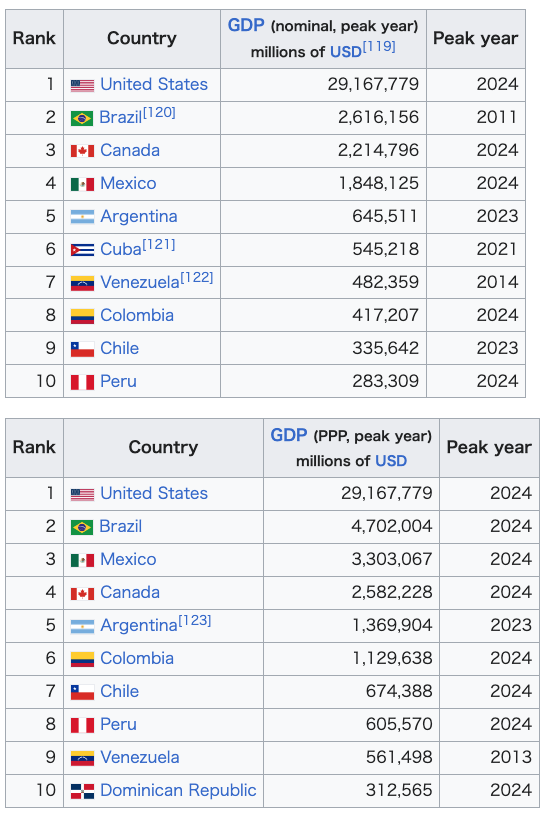 In exports and imports, in 2020, the United States was the world's second largest exporter (US$1.64 trillion) and the largest importer (US$2.56 trillion). Mexico was the tenth largest exporter and importer. Canada was the twelfth largest exporter and importer. Brazil was the 24th largest exporter and the 28th largest importer. Chile was the 45th largest exporter and the 47th largest importer. Argentina was the 46th largest exporter and the 52nd largest importer. Colombia was the 54th largest exporter and the 51st largest importer; among others.[124][125][126] The agriculture of the continent is very strong and varied. Countries such as United States, Brazil, Canada, Mexico, and Argentina are among the largest agricultural producers on the planet. In 2019, the continent dominated the world production of soy (almost 90% of the world total, with Brazil, the United States, Argentina, Paraguay, Canada and Bolivia among the 10 largest on the planet), sugarcane (about 55% of the world total, with Brazil, Mexico, the United States, and Guatemala among the 10 largest on the planet), coffee (about 55% of the world total, with Brazil, Colombia, Honduras, Peru, and Guatemala among the 10 largest on the planet) and maize (about 48% of the world total, with the United States, Brazil, Argentina, and Mexico among the 10 largest on the planet). The continent also produces almost 40% of world's orange (with Brazil, the United States, and Mexico among the top 10 producers), about 37% of world's pineapple (with Costa Rica, Brazil, Mexico, and Colombia among the 10 largest producers), about 35% of world's lemon (with Mexico, Argentina, Brazil, and the United States among the 10 largest producers) and about 30% of world's cotton (with the United States, Brazil, Mexico and Argentina among the top 10 producers), among several other products.[127] In livestock, America also has giant productions. In 2018, the continent produced around 45% of the world's beef (with the United States, Brazil, Argentina, Mexico, and Canada among the world's 10 largest producers); about 36% of the world's chicken meat (with the United States, Brazil, and Mexico among the world's 10 largest producers), and about 28% of the world's cow's milk (with the United States and Brazil among the 10 largest producers in the world), among other products.[127] In industrial terms, the World Bank lists the top producing countries each year, based on the total value of production. According to the 2019 list, the United States has the second most valuable industry in the world (US$2.3 trillion), Mexico has the 12th most valuable industry in the world (US$217.8 billion), Brazil has the 13th most valuable industry in the world (US$173.6 billion), Canada has the 15th most valuable industry in the world (US$151.7 billion), Venezuela the 30th largest (US$58.2 billion, but depends on the oil to obtain this amount), Argentina was the 31st largest (US$57.7 billion), Colombia the 46th largest (US$35.4 billion), Peru the 50th largest ($28.7 billion), and Chile the 51st largest (US$28.3 billion), among others.[128] In the production of oil, the continent had 8 of the 30 largest world producers in 2020: United States (1st), Canada (4th), Brazil (8th), Mexico (14th), Colombia (20th), Venezuela (26th), Ecuador (27th), and Argentina (28th).[129] In the production of natural gas, the continent had 8 of the 32 largest world producers in 2015: United States (1st), Canada (5th), Argentina (18th), Trinidad and Tobago (20th), Mexico (21st), Venezuela (28th), Bolivia (31st), and Brazil (32nd).[130][131] In the production of coal, the continent had 5 of the 30 largest world producers in 2018: United States (3rd), Colombia (12th), Canada (13th), Mexico (24th), and Brazil (27th).[132] In the production of vehicles, the continent had 5 of the 30 largest world producers in 2019: United States (2nd), Mexico (7th), Brazil (9th), Canada (12th), and Argentina (28th).[133] In the production of steel, the continent had 5 of the 31 largest world producers in 2019: United States (4th), Brazil (9th), Mexico (15th), Canada (18th), and Argentina (31st).[134][135] In mining, the continent has large productions of gold (mainly in the United States, Canada, Peru, Mexico, Brazil, and Argentina);[136] silver (mainly in Mexico, Peru, Chile, Bolivia, Argentina, and the United States);[137] copper (mainly in Chile, Peru, the United States, Mexico, and Brazil);[138] platinum (Canada and the United States);[139] iron ore (Brazil, Canada, the United States, Peru, and Chile);[140] zinc (Peru, the United States, Mexico, Bolivia, Canada, and Brazil);[141] molybdenum (Chile, Peru, Mexico, Canada, and the United States);[142] lithium (Chile, Argentina, Brazil, and Canada);[143] lead (Peru, the United States, Mexico, and Bolivia);[144] bauxite (Brazil, Jamaica, Canada, and the United States);[145] tin (Peru, Bolivia, and Brazil);[146] manganese (Brazil and Mexico);[147] antimony (Bolivia, Mexico, Guatemala, Canada, and Ecuador);[148] nickel (Canada, Brazil, Dominican Republic, Cuba, and the United States);[149] niobium (Brazil and Canada);[150] rhenium (Chile and the United States);[151] and iodine (Chile),[152] among others. Dominica, Panama, and the Dominican Republic have the fastest-growing economy in the Americas according to the International Monetary Fund (IMF),[153] 16, five to seven countries in the southern part of the Americas had weakening economies in decline, compared to only three countries in the northern part of the Americas.[154][155] Haiti has the lowest GDP per capita in the Americas, although its economy was growing slightly as of 2016.[154][155] |
購買力平価説(PPP) 輸出入において、2020年には米国は世界第2位の輸出国(1兆6400億米ドル)および世界最大の輸入国(2兆5600億米ドル)であった。メキシコは 輸出国および輸入国として世界第10位であった。カナダは輸出国および輸入国として世界第12位であった。ブラジルは輸出国として世界第24位、輸入国と して世界第28位であった。チリは輸出で45位、輸入で47位。アルゼンチンは輸出で46位、輸入で52位。コロンビアは輸出で54位、輸入で51位。そ の他。[124][125][126] 大陸の農業は非常に強く、多様性に富んでいる。アメリカ、ブラジル、カナダ、メキシコ、アルゼンチンなどの国々は、地球上で最大の農業生産国である。 2019年には、大陸は大豆(地球上の総生産量のほぼ90%を占め、ブラジル、アメリカ、アルゼンチン、パラグアイ、カナダ、ボリビアが地球上で10大生 産国に名を連ねる)、サトウキビ(地球上の総生産量の約55%を占め、 ブラジル、メキシコ、米国、グアテマラが世界10大生産国に名を連ねる)、コーヒー(ブラジル、コロンビア、ホンジュラス、ペルー、グアテマラが世界10 大生産国に名を連ねる)およびトウモロコシ(米国、ブラジル、アルゼンチン、メキシコが世界10大生産国に名を連ねる)などである。また、この大陸は世界 のオレンジの約40%(ブラジル、米国、メキシコが生産量トップ10入り)、世界のパイナップルの約37%(コスタリカ、ブラジル、メキシコ、コロンビア が生産量トップ10入り)、世界のレモンの約35%(メキシコ、アルゼンチン、ブラジル、米国が生産量トップ10入り) また、世界の綿花生産量の約30%(上位10カ国にはアメリカ、ブラジル、メキシコ、アルゼンチンが名を連ねる)など、その他にも多くの生産品目がある。 家畜においても、アメリカは巨大な生産量を誇っている。2018年には、アメリカ大陸は世界の牛肉生産量の約45%(世界10大生産国にはアメリカ、 ブラジル、アルゼンチン、メキシコ、カナダが世界10大生産国に名を連ねている)世界の鶏肉の約36%(アメリカ、ブラジル、メキシコが世界10大生産国 に名を連ねている)、世界の牛乳の約28%(アメリカとブラジルが世界10大生産国に名を連ねている)などである。 産業面では、世界銀行が毎年、生産総額に基づいて上位生産国をリストアップしている。2019年のリストによると、アメリカ合衆国は世界で2番目に価値の 高い産業(2兆3000億米ドル)を有し、メキシコは世界で12番目に価値の高い産業(2178億米ドル)を有し、 ブラジルは世界で13番目に価値の高い産業(1736億米ドル)、カナダは世界で15番目に価値の高い産業(1517億米ドル)、ベネズエラは30番目に 大きい(582 20億ドル、ただしこの金額は石油に依存している)、アルゼンチンは31番目(577億ドル)、コロンビアは46番目(354億ドル)、ペルーは50番目 (287億ドル)、チリは51番目(283億ドル)などとなっている。[128] 石油生産では、2020年時点で、アメリカ(1位)、カナダ(4位)、ブラジル(8位)、メキシコ(14位)、コロンビア(20位)、ベネズエラ(26位)、エクアドル(27位)、アルゼンチン(28位)の8カ国が世界30大産油国に入っている。 天然ガスの生産では、2015年には世界最大の生産国32か国のうち8か国がこの大陸にあった:米国(1位)、カナダ(5位)、アルゼンチン(18位)、 トリニダード・トバゴ(20位)、メキシコ(21位)、ベネズエラ(28位)、ボリビア(31位)、ブラジル(32位)。[130][131] 石炭生産では、2018年には大陸は世界30大生産国のうち5カ国を占めていた:米国(3位)、コロンビア(12位)、カナダ(13位)、メキシコ(24位)、ブラジル(27位)である。[132] 自動車生産では、2019年には、アメリカ(2位)、メキシコ(7位)、ブラジル(9位)、カナダ(12位)、アルゼンチン(28位)の5か国が世界30大生産国に入っている。[133] 鉄鋼生産では、2019年には世界最大の生産国31か国のうち5か国がこの大陸にあった:米国(4位)、ブラジル(9位)、メキシコ(15位)、カナダ(18位)、アルゼンチン(31位)。[134][135] 採掘では、大陸では金(主に米国、カナダ、ペルー、メキシコ、ブラジル、アルゼンチン)[136]、銀(主にメキシコ、ペルー、チリ、ボリビア、アルゼン チン、米国)[137]、銅(主にチリ、ペルー、 アメリカ、メキシコ、ブラジル);[138] プラチナ(カナダ、アメリカ);[139] 鉄鉱石(ブラジル、カナダ、アメリカ、ペルー、チリ);[140] 亜鉛(ペルー、アメリカ、メキシコ、ボリビア、カナダ、ブラジル);[141] モリブデン(チリ、ペルー、メキシコ、カナダ、アメリカ); [142] リチウム(チリ、アルゼンチン、ブラジル、カナダ)[143] 鉛(ペルー、米国、メキシコ、ボリビア)[144] ボーキサイト(ブラジル、ジャマイカ、カナダ、米国)[145] スズ(ペルー、ボリビア、ブラジル)[146] マンガン(ブラジル、メキシコ)[147] アンチモン(ボリビア、 メキシコ、グアテマラ、カナダ、エクアドル)[148]、ニッケル(カナダ、ブラジル、ドミニカ共和国、キューバ、アメリカ合衆国)[149]、ニオブ (ブラジル、カナダ)[150]、レニウム(チリ、アメリカ合衆国)[151]、ヨウ素(チリ)[152]などがある。 国際通貨基金(IMF)によると、ドミニカ国、パナマ、ドミニカ共和国はアメリカ州で最も経済成長が速い国々であるが、アメリカ州南部の5か国から7か国 では経済が衰退し弱体化している。 [154][155] ハイチはアメリカ州で一人当たりのGDPが最も低い国であるが、2016年時点では経済がわずかに成長していた。[154][155] |
| Demographics Population Further information: List of countries in the Americas by population In 2021 the total population of the Americas was about 1.03 billion people, divided as follows: North America: 596.6 million (includes Central America and the Caribbean) South America: 434.3 million Largest urban centers See also: Largest cities in the Americas and List of metropolitan areas in the Americas by population There are three urban centers that each hold titles for being the largest population area based on the three main demographic concepts:[156] City proper A city proper is the locality with legally fixed boundaries and an administratively recognized urban status that is usually characterized by some form of local government.[157][158][159][160][161] Urban area An urban area is characterized by higher population density and vast human features in comparison to areas surrounding it. Urban areas may be cities, towns or conurbations, but the term is not commonly extended to rural settlements such as villages and hamlets. Urban areas are created and further developed by the process of urbanization and do not include large swaths of rural land, as do metropolitan areas.[citation needed] Metropolitan area Unlike an urban area, a metropolitan area includes not only the urban area, but also satellite cities plus intervening rural land that is socio-economically connected to the urban core city, typically by employment ties through commuting, with the urban core city being the primary labor market.[citation needed] In accordance with these definitions, the three largest population centers in the Americas are: Mexico City, anchor to the largest metropolitan area in the Americas; New York City, anchor to the largest urban area in the Americas; and São Paulo, the largest city proper in the Americas. All three cities maintain Alpha classification and large scale influence. |
人口統計 人口 詳細情報:南北アメリカ大陸の人口が多い国一覧 2021年における南北アメリカ大陸の総人口は約10億3000万人であり、内訳は以下の通りである。 北アメリカ:5億9660万人(中央アメリカおよびカリブ海地域を含む 南アメリカ:4億3430万人 最大の都市圏 参照:南北アメリカ大陸の最大の都市および南北アメリカ大陸の人口が多い都市圏の一覧 人口が最も多い地域としてそれぞれに冠される3つの主要な人口統計概念に基づく3つの都市圏がある。[156] 市域 市域とは、通常は地方自治体によって特徴づけられる、法的境界が確定し行政上都市として認められた地域である。[157][158][159][160][161] 都市圏 都市圏は、周囲の地域と比較して人口密度が高く、人間的な特徴が顕著であるという特徴がある。都市圏は、都市、町、または都市圏であるが、この用語は、村 や村落などの農村集落には一般的に適用されない。都市圏は、都市化の過程で形成され、さらに発展するものであり、大都市圏のように広大な農村地帯を含まな い。 大都市圏 都市圏は、都市部だけでなく衛星都市、および都市中心部と社会経済的に結びついている(通常は通勤による雇用関係を通じて)中間にある農村地域も含む。都市中心部は主要な労働市場である。 これらの定義に従うと、アメリカ州で人口が最も多い3つの中心地は、アメリカ州最大の都市圏の中心地であるメキシコシティ、アメリカ州最大の都市圏の中心 地であるニューヨーク市、そしてアメリカ州最大の都市であるサンパウロである。これら3都市はすべてアルファ分類を維持しており、大きな影響力を有してい る。 |
| Ethnology This section does not cite any sources. Please help improve this section by adding citations to reliable sources. Unsourced material may be challenged and removed. (June 2014) (Learn how and when to remove this message) Ethnic map of the Americas (c. 1880) by Heinrich Berghaus The population of the Americas is made up of the descendants of four large ethnic groups and their combinations. The Indigenous peoples of the Americas, being Amerindians and Inuit-Yupik-Unangan. Those of European ancestry, mainly Spanish, English, Irish, Portuguese, German, Italian, French, and Dutch. Those of African ancestry, mainly of West African descent. Asians, that is, those of East Asian, Southeast Asian, and South Asian ancestry. Mestizos (Métis people in Canada), those of mixed European and Amerindian ancestry. Mulattoes, people of mixed African and European ancestry. Zambos (Spanish) or Cafuzos (Portuguese), those of mixed African and Indigenous ancestry. The majority of the population lives in Latin America, named for its predominant cultures, rooted in Latin Europe (including the two dominant languages, Spanish and Portuguese, both Romance languages), more specifically in the Iberian nations of Portugal and Spain (hence the use of the term Ibero-America as a synonym). Latin America is typically contrasted with Anglo-America, where English, a Germanic language, is prevalent, and which comprises Canada (with the exception of Francophone Canada rooted in Latin Europe [France]—see Quebec and Acadia) and the United States. Both countries are located in North America, with cultures deriving predominantly from British and other Germanic roots. |
民族学 この節には出典が全く示されていない。出典を追加して記事の信頼性向上にご協力ください。出典のない項目は、削除されることがあります。 (2014年6月) (Learn how and when to remove this message) ハインリッヒ・ベルゴースによるアメリカ大陸の民族地図(1880年頃) アメリカ大陸の人口は、4つの大きな民族集団とその組み合わせの子孫で構成されている。 アメリカ大陸の先住民は、アメリカインディアンとイヌイット・エスキモー・ウナガンである。 ヨーロッパ系の人々、主にスペイン人、イギリス人、アイルランド人、ポルトガル人、ドイツ人、イタリア人、フランス人、オランダ人。 アフリカ系の人々、主に西アフリカ系。 アジア人、すなわち東アジア、東南アジア、南アジア系。 メスチソ(カナダのメティス)、ヨーロッパ系とアメリカインディアン系の混血。 ムラート、アフリカ系とヨーロッパ系の混血。 ザンボ(スペイン)またはカフゾ(ポルトガル)は、アフリカと先住民の混血である。 人口の大半はラテンアメリカに住んでおり、その名称はラテンヨーロッパ(ロマンス諸語であるスペイン語とポルトガル語という2つの主要言語を含む)にルー ツを持つ文化が優勢であることに由来する。より具体的には、ポルトガルとスペインというイベリア半島の国民にルーツを持つ(そのため、同義語としてイベロ アメリカという用語が使われる)。ラテンアメリカは、ゲルマン語である英語が広く使われている英米諸国と対比される。英米諸国には、カナダ(ラテンヨー ロッパのフランスにルーツを持つフランス語圏のケベックとアカディアを除く)と米国が含まれる。両国は北米に位置し、文化は主に英国およびその他のゲルマ ン語に由来する。 |
Black population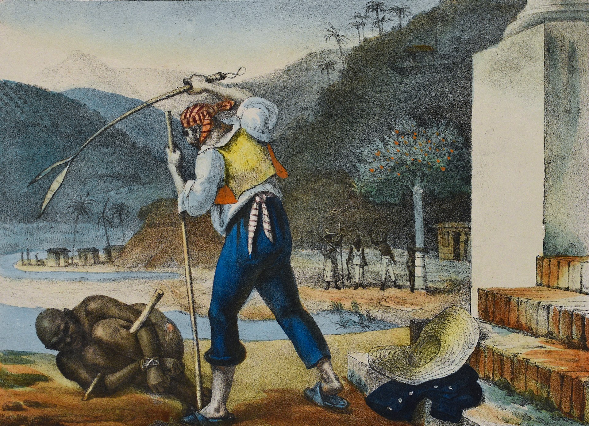 Slavery in Brazil by Jean-Baptiste Debret (1834–1839) The transatlantic slave trade brought millions of Africans to the territories of the Americas under the colonial rule of European powers. In South America, Portugal played a significant role in the trafficking of enslaved Africans, with estimates suggesting that around 40% of all Africans forcibly brought to the Americas were taken to Brazil alone, to work primarily in sugar cane plantations, mining, and agricultural endeavors.[168] In North America, the British Empire was heavily involved in the transatlantic slave trade, with the establishment of colonies such as Virginia, where enslaved Africans were primarily used as labor in tobacco plantations and later in other agricultural and domestic sectors. This system perpetuated for centuries, shaping the socio-economic landscape of all nations of the hemisphere. After the Haitian Revolution led by Jean-Jacques Dessalines, which started in 1791 and was the only successful slave revolt in history, the world's first black republic was established. It started with the massacre of the white population, between 3,000 and 5,000 white men and women of all ages were killed. Dessalines declared: Oui, nous avons rendu à ces vrais cannibales guerre pour guerre, crimes pour crimes, outrages pour outrages. Oui, j’ai sauvé mon pays, j’ai vengé l’Amérique. Yes, we have rendered to these true cannibals war for war, crime for crime, outrage for outrage; Yes, I have saved my country – I have avenged America. — Dessalines, first president of the Republic of Haiti, 1804[169][170] |
黒人人口 ジャン=バティスト・ドブレによるブラジルの奴隷制(1834年~1839年) 大西洋奴隷貿易により、ヨーロッパ諸国の植民地支配下にあるアメリカ大陸の領土に、何百万人ものアフリカ人が連れてこられた。南アメリカでは、ポルトガル が奴隷としてアフリカ人を売買する上で重要な役割を果たし、アメリカ大陸に強制的に連れてこられたアフリカ人の約40%がブラジルに連れてこられ、主にサ トウキビ農園、鉱山、農業で働かされたと推定されている。 [168] 北米では、大英帝国が大西洋奴隷貿易に深く関与し、バージニアなどの植民地を設立した。そこで奴隷として連れて来られたアフリカ人は主にタバコ農園で労働 力として使われ、後に他の農業や国内部門でも使われるようになった。このシステムは何世紀にもわたって続き、南北アメリカ大陸のすべての国の社会経済の風 景を形成した。 1791年に始まったジャン=ジャック・デサリンス率いるハイチ革命は、史上唯一成功した奴隷反乱であり、世界初の黒人共和国が誕生した。革命は白人の虐殺から始まり、あらゆる年齢層の白人男女3,000人から5,000人が殺害された。デサリンスは宣言した。 「我々は、これらの真の食人種に対して、戦争には戦争、犯罪には犯罪、暴虐には暴虐をもって報いたのだ。 そう、私は祖国を救い、アメリカに復讐したのだ。 「我々は、これらの真の食人種に対して、戦争には戦争、犯罪には犯罪、暴虐には暴虐をもって報いたのだ。 そう、私は祖国を救い、アメリカに復讐したのだ。 — ハイチ共和国初代大統領、1804年 デサリン[169][170] |
| Religion Further information: Religion in Latin America, Religion in North America, Christianity in the Americas, and Islam in the Americas The most prevalent faiths in the Americas are as follows: 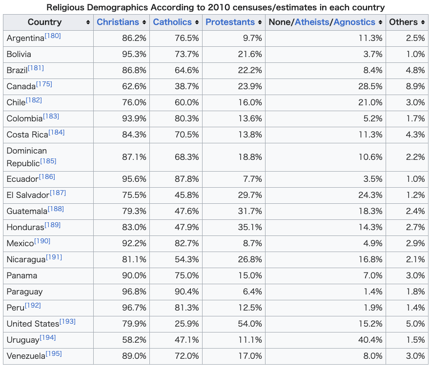 Christianity (86 percent)[171] Roman Catholicism: Practiced by 69 percent[172] of the Latin American population (61 percent[172] in Brazil whose Roman Catholic population of 134 million[173] is the greatest of any nation's), approximately 24 percent of the United States' population[174] and about 39 percent of Canada's.[175] Protestantism: Practiced mostly in the United States, where half of the population are Protestant, Canada, with slightly more than a quarter of the population, and Greenland; there is a growing contingent of Evangelical and Pentecostal movements in predominantly Catholic Latin America.[176] Eastern Orthodoxy: Found mostly in the United States (1 percent) and Canada; this Christian group is growing faster than many other Christian groups in Canada and now represents roughly 3 percent of the Canadian population.[175] Non-denominational Christians and other Christians (some 1,000 different Christian denominations and sects practiced in the Americas). Irreligion: About 12 percent, including atheists and agnostics, as well as those who profess some form of spirituality but do not identify themselves as members of any organized religion. Islam: Together, Muslims constitute about 1 percent of the North American population and 0.3 percent of all Latin Americans. It is practiced by 3 percent[175] of Canadians and 0.6 percent of the U.S. population.[174] Argentina has the largest Muslim population in Latin America with up to 600,000 persons, or 1.5 percent of the population.[177] Judaism: Practiced by 2 percent of North Americans—approximately 2.5 percent of the U.S. population and 1.2 percent of Canadians[178]—as well as 0.23 percent of Latin Americans. Argentina has the largest Jewish population in Latin America with 200,000 members.[179] Other faiths include Buddhism; Hinduism; Sikhism; Baháʼí Faith; a wide variety of indigenous religions, many of which can be categorized as animistic; new age religions and many African and African-derived religions. Syncretic faiths can also be found throughout the Americas. |
宗教 詳細情報:ラテンアメリカの宗教、北アメリカの宗教、アメリカ大陸のキリスト教、アメリカ大陸のイスラム教 アメリカ大陸で最も広く信仰されている宗教は以下の通りである。 キリスト教(86パーセント)[171] ローマ・カトリック:ラテンアメリカ人口の69%(ブラジルでは61%[172])が信仰しており、ブラジルには1億3,400万人[173]のローマ・ カトリック教徒がおり、これは世界で最も多い。また、米国人口の約24%[174]、カナダの約39%[175]が信仰している。 プロテスタント:主にアメリカ合衆国で信仰されており、人口の半分がプロテスタントである。カナダでは人口の4分の1強がプロテスタントであり、グリーン ランドでも信仰されている。ラテンアメリカでは、カトリックが主流であるが、福音派やペンテコステ派の信者が増加している。 東方正教会:主に米国(1%)とカナダに存在する。このキリスト教グループはカナダでは他の多くのキリスト教グループよりも急速に成長しており、現在ではカナダ人口のおよそ3%を占めている。 無宗派のキリスト教徒およびその他のキリスト教徒(南北アメリカ大陸で信仰されている約1,000の異なるキリスト教の宗派や教団)。 無宗教:約12パーセント。無神論者や不可知論者、また、何らかの形の精神性を信奉しているが、特定の組織宗教の信者であると名乗らない人々を含む。 イスラム教:北米の人口の約1%、ラテンアメリカ全体の人口の0.3%をイスラム教徒が占める。カナダでは人口の3%[175]、米国では人口の0.6% [174]がイスラム教を信仰している。アルゼンチンにはラテンアメリカ最大のイスラム教徒人口があり、最大600,000人、すなわち人口の1.5%を 占める[177]。 ユダヤ教:北米では人口の2パーセント、すなわち米国の人口の約2.5パーセント、カナダの人口の1.2パーセントが信仰している。また、ラテンアメリカ では人口の0.23パーセントが信仰している。アルゼンチンにはラテンアメリカ最大のユダヤ人人口があり、20万人が信仰している。 その他の信仰としては、仏教、ヒンドゥー教、シク教、バハーイ教、多種多様な土着宗教(その多くは精霊信仰に分類される)、ニューエイジ宗教、アフリカおよびアフリカ由来の宗教などがある。アメリカ大陸全体では、混成宗教も見られる。 |
| Languages Main articles: Indigenous languages of the Americas, Languages of North America, and Languages of South America Languages spoken in the Americas Various languages are spoken in the Americas. Some are of European origin, others are spoken by indigenous peoples or are the mixture of various languages like the different creoles.[184] The most widely spoken first language in the Americas is Spanish, followed by English and Portuguese.[196] The dominant language of Latin America is Spanish, though the most populous nation in Latin America, Brazil, speaks Portuguese. Small enclaves of French-, Dutch- and English-speaking regions also exist in Latin America, notably in French Guiana, Suriname, and Belize and Guyana respectively. Haitian Creole is dominant in the nation of Haiti, where French is also spoken. Native languages are more prominent in Latin America than in Anglo-America, with Nahuatl, Quechua, Aymara, and Guaraní as the most common. Various other native languages are spoken with less frequency across both Anglo-America and Latin America. Creole languages other than Haitian Creole are also spoken in parts of Latin America. The dominant language of Anglo-America is English. French is also official in Canada, where it is the predominant language in Quebec and an official language in New Brunswick along with English. It is also an important language in Louisiana, and in parts of New Hampshire, Maine, and Vermont. Spanish has kept an ongoing presence in the Southwestern United States, which formed part of the Viceroyalty of New Spain, especially in California and New Mexico, where a distinct variety of Spanish spoken since the 17th century has survived. It has more recently become widely spoken in other parts of the United States because of heavy immigration from Latin America. High levels of immigration in general have brought great linguistic diversity to Anglo-America, with over 300 languages known to be spoken in the United States alone, but most languages are spoken only in small enclaves and by relatively small immigrant groups. The nations of Guyana, Suriname, and Belize are generally considered[by whom?] not to fall into either Anglo-America or Latin America because of their language differences from Latin America, geographic differences from Anglo-America, and cultural and historical differences from both regions; English is the primary language of Guyana and Belize, and Dutch is the primary language of Suriname. Most of the non-native languages have, to different degrees, evolved differently from the mother country, but are usually still mutually intelligible. Some have combined, however, which has even resulted in completely new languages, such as Papiamento, which is a combination of Portuguese, Spanish, Dutch (representing the respective colonizers), native Arawak, various African languages, and, more recently English. The lingua franca Portuñol, a mixture of Portuguese and Spanish, is spoken in the border regions of Brazil and neighboring Spanish-speaking countries.[197] More specifically, Riverense Portuñol is spoken by around 100,000 people in the border regions of Brazil and Uruguay. Because of immigration, there are many communities where other languages are spoken from all parts of the world, especially in the United States, Brazil, Argentina, Canada, Chile, Costa Rica, and Uruguay—very important destinations for immigrants.[198][199][200] |
言語 主な記事:アメリカ大陸の先住民言語、北アメリカの言語、南アメリカの言語 アメリカ大陸で話されている言語 アメリカ大陸ではさまざまな言語が話されている。ヨーロッパ起源の言語もあれば、先住民が話す言語や、異なるクレオール語のようにさまざまな言語が混ざったものもある。 アメリカ州で最も広く話されている第一言語はスペイン語であり、次いで英語、ポルトガル語の順である。[196] ラテンアメリカで最も人口の多い国ブラジルではポルトガル語が話されているが、ラテンアメリカで支配的な言語はスペイン語である。ラテンアメリカには、フ ランス語、オランダ語、英語を話す地域も点在しており、特にフランス領ギアナ、スリナム、ベリーズ、ガイアナにそれぞれ存在している。ハイチではハイチ・ クレオール語が主流であるが、フランス語も話されている。ラテンアメリカでは、英語圏よりもネイティブ言語が広く話されており、ナワトル語、ケチュア語、 アイマラ語、グアラニー語などがよく使われている。その他のネイティブ言語は、英語圏でもラテンアメリカでも、あまり頻繁には話されていない。ハイチ・ク レオール語以外のクレオール語も、ラテンアメリカの一部で話されている。 英米圏で最も広く使用されている言語は英語である。フランス語はカナダでも公用語であり、ケベック州ではフランス語が優勢な言語であり、ニューブランズ ウィック州では英語とともに公用語である。また、ルイジアナ州やニューハンプシャー州、メイン州、バーモント州の一部でも重要な言語である。スペイン語 は、かつてヌエバ・エスパーニャ副王領の一部であったアメリカ南西部、特にカリフォルニア州やニューメキシコ州では現在も広く使用されており、17世紀か ら話されている独特のスペイン語が今も生き残っている。最近ではラテンアメリカからの移民が多数であるため、アメリカ合衆国の他の地域でも広く話されるよ うになった。一般的に高度な移民は、英語圏のアメリカに大きな言語的多様性をもたらし、アメリカ合衆国だけで300以上の言語が話されていることが知られ ているが、ほとんどの言語は、小さな飛び地や比較的小規模な移民グループのみで話されている。 ガイアナ、スリナム、ベリーズの国民は、一般的に、ラテンアメリカとは言語が異なり、英米諸国とも地理的に異なり、両地域とも文化や歴史が異なるため、英 米諸国にもラテンアメリカにも属さないと考えられている[誰によって?]。ガイアナとベリーズでは英語が主要言語であり、スリナムではオランダ語が主要言 語である。 非ネイティブ言語のほとんどは、程度の差こそあれ、母国とは異なる形で発展してきたが、通常は依然として相互に理解できる。しかし、いくつかの言語は融合 し、ポルトガル語、スペイン語、オランダ語(それぞれ植民地支配者の言語)、先住民のアラワク語、さまざまなアフリカの言語、そして最近では英語が融合し たパピアメント語のように、まったく新しい言語を生み出す結果となった。ポルトガル語とスペイン語の混合語である共通語「ポルトゥニョール」は、ブラジル と近隣のスペイン語圏諸国の国境地帯で話されている。[197] さらに具体的には、リベイラン・プレト・ポルトゥニョールは、ブラジルとウルグアイの国境地帯で約10万人の人々によって話されている。移民の流入によ り、特にアメリカ、ブラジル、アルゼンチン、カナダ、チリ、コスタリカ、ウルグアイなど、移民にとって重要な目的地となっている国々では、世界中のさまざ まな言語が話されているコミュニティが数多く存在している。[198][199][200] |
| Culture Main articles: Culture of North America and Culture of Latin America Sports See also: Pan American Championship Baseball is one of the most popular sports in the Americas, having spread through the hemisphere after the growth of US influence in the late 19th century. It overtook cricket, a fellow bat-and-ball sport spread by earlier British influence, in most places outside of the Commonwealth Caribbean. Other American sports, such as basketball, have grown throughout the region over time.[201] |
文化 詳細は「北アメリカの文化」および「ラテンアメリカの文化」を参照 スポーツ 関連項目:パンアメリカン競技大会 野球はアメリカ州で最も人気のあるスポーツのひとつであり、19世紀後半にアメリカの影響力が拡大したことにより、アメリカ州全体に広まった。野球は、そ れ以前にイギリスの影響力によって広まった同じ打撃球技であるクリケットを、英連邦カリブ地域以外のほとんどの地域で追い越した。バスケットボールなどの 他のアメリカ発祥のスポーツも、この地域全体で徐々に広まった。[201] |
| Alliance for Progress American Capital of Culture Andean Community of Nations Association of Caribbean States Bank of the South Bolivarian Alternative for the Americas Caribbean Community CARICOM Single Market and Economy Central American Common Market Central American Parliament Community of Latin American and Caribbean States Contadora Group Free Trade Area of the Americas Latin American Free Trade Agreement Latin American Parliament or Parlatino Mercosur or Mercosul North Atlantic Treaty Organization Organization of American States Organisation of Eastern Caribbean States Organization of Ibero-American States Pacific Alliance Pan American Sports Organization Regional Security System Rio Group School of the Americas Summit of the Americas Union of South American Nations United States–Mexico–Canada Agreement YOA Orchestra of the Americas |
進歩のための同盟 アメリカ文化首都 アンデス共同体の国民 カリブ共同体 南米銀行 アメリカ大陸のためのボリバル代替案 カリブ共同体 カリコム単一市場および経済 中米共同市場 中米議会 ラテンアメリカおよびカリブ共同体 コントドーラ・グループ 米州自由貿易地域 ラテンアメリカ自由貿易協定 ラテンアメリカ議会またはパルラティーノ メルコスールまたはメルコスル 北大西洋条約機構 米州機構 東カリブ諸国機構 イベロアメリカ諸国機構 太平洋同盟 パンアメリカンスポーツ機構 地域安全保障システム リオ・グループ 米州学校 米州サミット 南米諸国連合 米国・メキシコ・カナダ協定 米州オーケストラ |
| Amerrisque Mountains Abya Yala – indigenous name for the North and South American continents British North America Columbia (name) Ethnic groups in Central America French America Indigenous Peoples' Day La Merika List of conflicts in the Americas List of former sovereign states List of oldest buildings in the Americas Monarchies in the Americas New Sweden Pan-Americanism Pan-American Highway Pan American Games Personification of the Americas Southern Cone |
アメリカ合衆国 アバイア・ヤラ - 北米と南米大陸の原住民による名称 イギリス領北アメリカ コロンビア(名称 中央アメリカにおける民族グループ フランス領アメリカ 先住民の日 ラ・メリカ 南北アメリカにおける紛争の一覧 かつての主権国家の一覧 南北アメリカ大陸で最も古い建築物の一覧 南北アメリカにおける君主制 新スウェーデン 汎アメリカ主義 汎アメリカハイウェイ パンアメリカンゲームズ 南北アメリカ大陸の擬人化 南米南部 |
| Further reading "Americas". The Columbia Gazetteer of the World Online. New York: Columbia University Press, 2006. "Americas". Encyclopædia Britannica, 15th ed. Chicago: Encyclopædia Britannica, Inc., 1986. ISBN 0-85229-434-4 Burchfield, R. W. Fowler's Modern English Usage. Oxford: Oxford University Press, 2004. ISBN 0-19-861021-1 Fee, Margery, and J. McAlpine. Oxford Guide to Canadian English Usage. Toronto: Oxford University Press, 1997. ISBN 0-19-541619-8 Kane, Katie (1999). "Nits Make Lice: Drogheda, Sand Creek, and the Poetics of Colonial Extermination". Cultural Critique. 42 (42): 81–103. doi:10.2307/1354592. JSTOR 1354592. Pearsall, Judy, and Bill Trumble, ed. Oxford English Reference Dictionary, 2nd ed. (rev.). Oxford: Oxford University Press, 2002. ISBN 0-19-860652-4 Rosenberg, Matt (9 April 2018). "How to Define North, South, Latin, and Anglo America". ThoughtCo. |
さらに読む 「アメリカ大陸」。コロンビア・オンライン世界地誌。ニューヨーク:コロンビア大学出版局、2006年。 「アメリカ大陸」。ブリタニカ百科事典第15版。シカゴ:Encyclopædia Britannica, Inc.、1986年。ISBN 0-85229-434-4 Burchfield, R. W. Fowler's Modern English Usage. Oxford: Oxford University Press, 2004. ISBN 0-19-861021-1 Fee, Margery, and J. McAlpine. Oxford Guide to Canadian English Usage. Toronto: Oxford University Press, 1997. ISBN 0-19-541619-8 ケイン、ケイティ(1999年)。「シラミがシラミを生む:ドロヘダ、サンドクリーク、植民地絶滅政策の詩学」。『Cultural Critique』42 (42): 81–103. doi:10.2307/1354592. JSTOR 1354592. ピアソル、ジュディ、ビル・トランブル編。オックスフォード英語辞典第2版(改訂版)。オックスフォード:オックスフォード大学出版局、2002年。ISBN 0-19-860652-4 ローゼンバーグ、マット(2018年4月9日)。「北米、中南米、ラテンアメリカ、およびアングロアメリカを定義する方法」。ThoughtCo。 |
| https://en.wikipedia.org/wiki/Americas |
リ ンク
文 献
そ の他の情報
CC
Copyleft, CC, Mitzub'ixi Quq Chi'j, 1996-2099
![]()
☆
 ☆
☆