カリブ海・カリブ海地方
Caribbean Sea
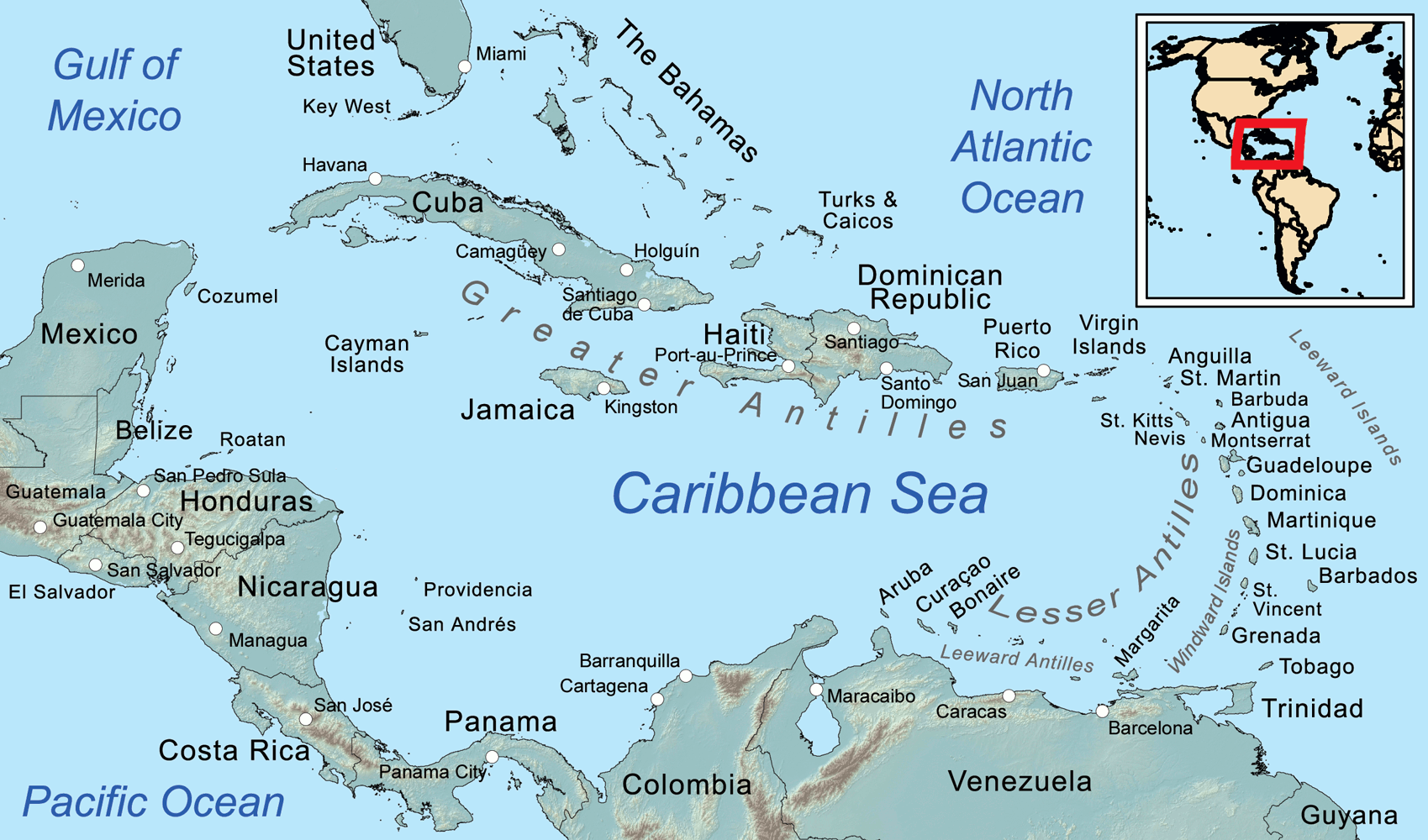
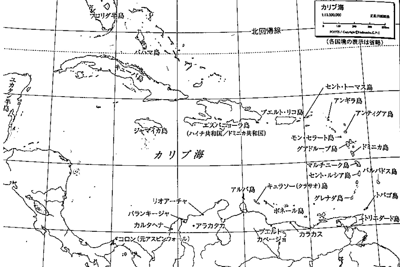
☆ カリブ海は、西半球の熱帯にある大西洋の海である。西と南西はメキシコと中央アメリカ、北はキューバを始めとする大アンティル諸島、東は小アンティル諸 島、南は南アメリカ大陸北岸に囲まれている。北西にはメキシコ湾がある。 カリブ海全域、西インド諸島の多数の島々、および隣接する海岸を総称してカリブ海と呼ぶ。カリブ海は地球上で最も大きな海のひとつであり、面積は約 2,754,000 km2 (1,063,000平方マイル)[2][3]。海の最深部はケイマン諸島とジャマイカの間にあるケイマン・トラフで、海面下7,686 m (25,217 ft)である。カリブ海沿岸には、ゴナベ湾、ベネズエラ湾、ダリエン湾、ゴルフォ・デ・ロス・モスキートス、パリア湾、ホンジュラス湾など、多くの湾や入 り江がある。 カリブ海には、世界で2番目に大きいバリアリーフ、メソアメリカン・バリア・リーフがある。メキシコ、ベリーズ、グアテマラ、ホンジュラス[4]の海岸に 沿って1,000km(620マイル)続いている。
| The Caribbean Sea[1]
is a sea of the Atlantic Ocean in the tropics of the Western
Hemisphere. It is bounded by Mexico and Central America to the west and
southwest, to the north by the Greater Antilles starting with Cuba, to
the east by the Lesser Antilles, and to the south by the northern coast
of South America. The Gulf of Mexico lies to the northwest. The entire Caribbean Sea area, the West Indies' numerous islands, and adjacent coasts are collectively known as the Caribbean. The Caribbean Sea is one of the largest seas on Earth and has an area of about 2,754,000 km2 (1,063,000 sq mi).[2][3] The sea's deepest point is the Cayman Trough, between the Cayman Islands and Jamaica, at 7,686 m (25,217 ft) below sea level. The Caribbean coastline has many gulfs and bays: the Gulf of Gonâve, the Gulf of Venezuela, the Gulf of Darién, Golfo de los Mosquitos, the Gulf of Paria and the Gulf of Honduras. The Caribbean Sea has the world's second-largest barrier reef, the Mesoamerican Barrier Reef. It runs 1,000 km (620 mi) along the Mexico, Belize, Guatemala, and Honduras[4] coasts. |
カリブ海[1]は、西半球の熱帯にある大西洋の海である。西と南西はメ
キシコと中央アメリカ、北はキューバを始めとする大アンティル諸島、東は小アンティル諸島、南は南アメリカ大陸北岸に囲まれている。北西にはメキシコ湾が
ある。 カリブ海全域、西インド諸島の多数の島々、および隣接する海岸を総称してカリブ海と呼ぶ。カリブ海は地球上で最も大きな海のひとつであり、面積は約 2,754,000 km2 (1,063,000平方マイル)[2][3]。海の最深部はケイマン諸島とジャマイカの間にあるケイマン・トラフで、海面下7,686 m (25,217 ft)である。カリブ海沿岸には、ゴナベ湾、ベネズエラ湾、ダリエン湾、ゴルフォ・デ・ロス・モスキートス、パリア湾、ホンジュラス湾など、多くの湾や入 り江がある。 カリブ海には、世界で2番目に大きいバリアリーフ、メソアメリカン・バリア・リーフがある。メキシコ、ベリーズ、グアテマラ、ホンジュラス[4]の海岸に 沿って1,000km(620マイル)続いている。 |
| History Main article: History of the Caribbean Christopher Columbus landing on Hispaniola in 1492 The name Caribbean derives from the Caribs, one of the region's dominant Native American groups at the time of European contact during the late 15th century. After Christopher Columbus landed in the Bahamas in 1492, the Spanish term Antillas applied to the lands; stemming from this, the Sea of the Antilles became a common alternative name for the "Caribbean Sea" in various European languages. Spanish dominance in the region remained undisputed during the first century of European colonization. From the 16th century, Europeans visiting the Caribbean region distinguished the "South Sea" (the Pacific Ocean south of the isthmus of Panama) from the "North Sea" (the Caribbean Sea north of the same isthmus).[5] Tulum, a Mayan city on the coast of the Caribbean in the state of Quintana Roo, Mexico The Caribbean Sea had been unknown to the populations of Eurasia until 1492 when Christopher Columbus sailed into Caribbean waters on a quest to find a sea route to Asia. At that time the Americas were generally unknown to most Europeans, although they had been visited in the 10th century by the Vikings. Following Columbus's discovery of the islands, the area was quickly colonized by several Western cultures (initially Spain, then later England, the Dutch Republic, France, Courland and Denmark). Following the colonization of the Caribbean islands, the Caribbean Sea became a busy area for European-based marine trading and transports, and this commerce eventually attracted pirates such as Samuel Bellamy and Blackbeard. As of 2015 the area is home to 22 island territories and borders 12 continental countries. |
沿革 主な記事 カリブ海の歴史 1492年、イスパニョーラに上陸したクリストファー・コロンブス カリブ海という名前は、15世紀後半にヨーロッパ人と接触した当時、この地域を支配していたネイティブ・アメリカン集団のひとつであるカリブ族に由来す る。1492年にクリストファー・コロンブスがバハマに上陸した後、スペイン語のアンティージャス(Antillas)という言葉がその土地に適用され た。これに由来して、アンティル諸島の海は、ヨーロッパの様々な言語で「カリブ海」の一般的な別名となった。ヨーロッパの植民地化が始まった最初の1世 紀、この地域におけるスペインの優位は揺るぎないものだった。 16世紀以降、カリブ海地域を訪れるヨーロッパ人は「南海」(パナマ地峡以南の太平洋)と「北海」(同地峡以北のカリブ海)を区別していた[5]。 メキシコ、キンタナ・ロー州のカリブ海沿岸にあるマヤの都市トゥルム 1492年、クリストファー・コロンブスがアジアへの航路を探すためにカリブ海を航海するまで、カリブ海はユーラシア大陸の人々には知られていなかった。 当時、アメリカ大陸は、10世紀にヴァイキングが訪れていたものの、ほとんどのヨーロッパ人には知られていなかった。コロンブスが島々を発見した後、この 地域は西洋文化圏(最初はスペイン、後にイギリス、オランダ共和国、フランス、クールランド、デンマーク)によって急速に植民地化された。カリブ海の島々 が植民地化された後、カリブ海はヨーロッパを拠点とする海洋貿易や輸送で賑わう地域となり、この商業はやがてサミュエル・ベラミーや黒ひげといった海賊を 惹きつけた。 2015年現在、この地域には22の島嶼地域があり、12の大陸諸国と国境を接している。 |
| Extent The International Hydrographic Organization defines the limits of the Caribbean Sea as follows:[6] On the North. In the Windward Channel – a line joining Caleta Point (74°15′W) in Cuba and Pearl Point (19°40′N) in Haiti. In the Mona Passage – a line joining Cape Engaño and the extreme of Agujereada (18°31′N 67°08′W) in Puerto Rico. Eastern limits. From Point San Diego (Puerto Rico) Northward along the meridian thereof (65°39′W) to the 100-fathom line, thence Eastward and Southward, in such a manner that all islands, shoals and narrow waters of the Lesser Antilles are included in the Caribbean Sea as far as Galera Point (Northeast extremity of the island of Trinidad). From Galera Point through Trinidad to Galeota Point (Southeast extreme) and thence to Baja Point (9°32′N 61°0′W) in Venezuela. Although Barbados is an island on the same continental shelf, it is considered to be in the Atlantic Ocean rather than the Caribbean Sea.[7] |
範囲 国際水路機関はカリブ海の限界を以下のように定義している[6]。 北側。ウィンドワード海峡では、キューバのカレタ岬(74°15′W)とハイチのパール岬(19°40′N)を結ぶ線。モナ海峡-エンガニョ岬とプエルト リコのアグヘレダ岬(18°31′N 67°08′W)を結ぶ線。 東の限界。サン・ディエゴ岬(プエルトリコ)から子午線(65°39′W)に沿って北上し、100ヒロ線まで、そこから小アンティル諸島のすべての島、浅 瀬および狭い海域がカリブ海に含まれるように東進および南進し、ガレラ岬(トリニダード島の北東端)まで。ガレラ岬からトリニダード島を経てガレオタ岬 (南東端)に至り、そこからベネズエラのバハ岬(9°32′N 61°0′W)に至る。 バルバドスは同じ大陸棚にある島であるが、カリブ海ではなく大西洋にあると考えられている[7]。 |
| Geology The Caribbean Sea is an oceanic sea on the Caribbean Plate. The Caribbean Sea is separated from the ocean by several island arcs of various ages. The youngest stretches from the Lesser Antilles to the Virgin Islands to the northeast of Trinidad and Tobago off the coast of Venezuela. This arc was formed by the collision of the South American Plate with the Caribbean Plate. It included active and extinct volcanoes such as Mount Pelee, the Quill on Sint Eustatius in the Caribbean Netherlands, La Soufrière in Saint Vincent and the Grenadines and Morne Trois Pitons on Dominica. The larger islands in the northern part of the sea Cuba, Hispaniola, Jamaica and Puerto Rico lie on an older island arc. 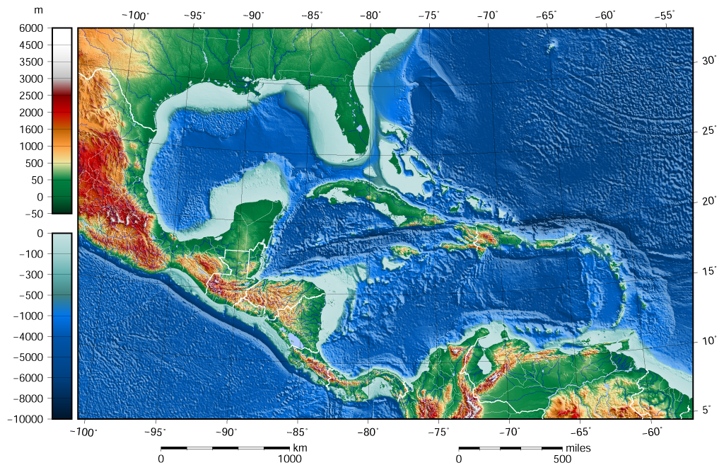 The shaded relief map of the Caribbean Sea and the Gulf of Mexico area[8][9] The geological age of the Caribbean Sea is estimated to be between 160 and 180 million years and was formed by a horizontal fracture that split the supercontinent called Pangea in the Mesozoic Era.[10] It is assumed the proto-caribbean basin existed in the Devonian period and in the early Carboniferous movement of Gondwana to the north and its convergence with the Euramerica basin decreased in size. The next stage of the Caribbean Sea's formation began in the Triassic. Powerful rifting led to the formation of narrow troughs, stretching from modern Newfoundland to the Gulf of Mexico's west coast, forming siliciclastic sedimentary rocks. In the early Jurassic due to powerful marine transgression, water broke into the present area of the Gulf of Mexico creating a vast shallow pool. Deep basins emerged in the Caribbean during the Middle Jurassic rifting. The emergence of these basins marked the beginning of the Atlantic Ocean and contributed to the destruction of Pangaea at the end of the late Jurassic. During the Cretaceous the Caribbean acquired a shape close to today. In the early Paleogene due to marine regression the Caribbean became separated from the Gulf of Mexico and the Atlantic Ocean by the land of Cuba and Haiti. The Caribbean remained like this for most of the Cenozoic until the Holocene when rising water levels of the oceans restored communication with the Atlantic Ocean. The Caribbean's floor is composed of sub-oceanic sediments of deep red clay in the deep basins and troughs. On continental slopes and ridges calcareous silts are found. Clay minerals have likely been deposited by the mainland river Orinoco and the Magdalena River. Deposits on the bottom of the Caribbean Sea and the Gulf of Mexico have a thickness of about 1 km (0.62 mi). Upper sedimentary layers relate to the period from the Mesozoic to the Cenozoic (250 million years ago) and the lower layers from the Paleozoic to the Mesozoic. 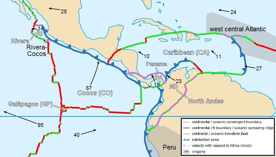 Caribbean plate tectonics The Caribbean seafloor is divided into five basins separated from each other by underwater ridges and mountain ranges. Atlantic Ocean water enters the Caribbean through the Anegada Passage between the Lesser Antilles and the Virgin Islands and the Windward Passage between Cuba and Haiti. The Yucatán Channel between Mexico and Cuba links the Gulf of Mexico with the Caribbean. The deepest points of the sea lie in Cayman Trough with depths reaching approximately 7,686 m (25,220 ft). Despite this, the Caribbean Sea is considered a relatively shallow sea compared to other bodies of water. The pressure of the South American Plate to the east of the Caribbean causes the region of the Lesser Antilles to have high volcanic activity. A very serious eruption of Mount Pelée in 1902 caused many casualties. The Caribbean sea floor is also home to two oceanic trenches: the Cayman Trench and the Puerto Rico Trench, which put the area at a high risk of earthquakes. Underwater earthquakes pose a threat of generating tsunamis which could have a devastating effect on the Caribbean islands. Scientific data reveals that over the last 500 years, the area has seen a dozen earthquakes above 7.5 magnitude.[11] Most recently, a 7.1 earthquake struck Haiti on January 12, 2010. |
地質学 カリブ海はカリブ海プレート上にある海洋である。カリブ海は、様々な年代のいくつかの島弧によって海から隔てられている。最も若いものは小アンティル諸島 からバージン諸島、ベネズエラ沖のトリニダード・トバゴの北東まで伸びている。この弧は、南米プレートとカリブ海プレートの衝突によって形成された。カリ ブ海のオランダ領シント・ユースタティウス島のペリー山、クイル山、セントビンセント・グレナディーン諸島のラ・スフリエール山、ドミニカ島のモーン・ト ロワ・ピトン山などの活火山や死火山が含まれていた。海の北部にある大きな島々キューバ、イスパニョーラ、ジャマイカ、プエルトリコは、古い島弧の上にあ る。 カリブ海とメキシコ湾地域の陰影付きレリーフマップ[8][9]。 カリブ海の地質年代は1億6,000万年から1億8,000万年と推定され、中生代にパンゲアと呼ばれる超大陸を分断した水平断裂によって形成された [10]。原カリブ海盆地はデボン紀に存在し、石炭紀初期にゴンドワナが北に移動し、ユーラメリカ盆地との収束が縮小したと考えられている。カリブ海形成 の次の段階は三畳紀に始まった。強力なリフティングによって、現在のニューファンドランドからメキシコ湾西岸に伸びる狭いトラフが形成され、珪長質の堆積 岩が形成された。ジュラ紀初期には、強力な海進によって現在のメキシコ湾に水が入り込み、広大な浅いプールが形成された。ジュラ紀中期のリフティングで、 カリブ海に深い盆地が出現した。これらの盆地の出現は大西洋の始まりであり、後期ジュラ紀の終わりにパンゲアが破壊される一因となった。白亜紀には、カリ ブ海は今日に近い形になった。カリブ海は、古第三紀初期に海洋退行によってメキシコ湾と大西洋からキューバとハイチの陸地によって分離された。カリブ海 は、海洋の水位が上昇して大西洋との連絡が回復する完新世まで、新生代のほとんどをこの状態で過ごした。 カリブ海の海底は、深い盆地や谷の深い赤土の海底堆積物で構成されている。大陸の斜面や尾根では石灰質のシルトが見られる。粘土鉱物は、おそらく本土のオ リノコ川とマグダレナ川によって堆積したものであろう。カリブ海とメキシコ湾の海底の堆積物の厚さは約1kmである。上層の堆積層は中生代から新生代(2 億5,000万年前)、下層の堆積層は古生代から中生代に関連する。 カリブ海のプレートテクトニクス カリブ海の海底は、海底尾根と山脈によって互いに隔てられた5つの盆地に分かれている。大西洋の海水は、小アンティル諸島とバージン諸島の間のアネガダ海 峡と、キューバとハイチの間のウィンドワード海峡を通ってカリブ海に入る。メキシコとキューバの間にあるユカタン海峡は、メキシコ湾とカリブ海を結んでい る。カリブ海の最深部はケイマン・トラフにあり、水深は約7,686m(25,220フィート)に達する。にもかかわらず、カリブ海は他の海域に比べると 比較的浅い海と考えられている。カリブ海の東にある南米プレートの圧力により、小アンティル諸島の地域は火山活動が活発である。1902年のペレ山の大噴 火は、多くの死傷者を出した。 カリブ海の海底には、ケイマン海溝とプエルトリコ海溝という2つの海溝があり、この地域は地震の危険性が高い。海底地震は津波を発生させ、カリブ海の島々 に壊滅的な影響を与える恐れがある。科学的データによると、過去500年間に、この地域ではマグニチュード7.5を超える地震が12回発生している [11]。最近では、2010年1月12日に7.1の地震がハイチを襲った。 |
| Oceanography Sketch of the North Equatorial Current and the Gulf Stream The hydrology of the sea has a high level of homogeneity. Annual variations in monthly average water temperatures at the surface do not exceed 3 °C (5.4 °F). Over the past 50 years, the Caribbean has gone through three stages: cooling until 1974, a cold phase with peaks during 1974–1976 and 1984–1986, and finally a warming phase with an increase in temperature of 0.6 °C (1.1 °F) per year. Virtually all temperature extremes were associated with the phenomena of El Niño and La Niña. The salinity of the seawater is about 3.6%, and its density is 1,023.5–1,024.0 kg/m3 (63.90–63.93 lb/cu ft). The surface water color is blue-green to green. The Caribbean's depth in its wider basins and deep-water temperatures are similar to those of the Atlantic. Atlantic deep water is thought to spill into the Caribbean and contribute to the general deep water of its sea.[12] The surface water (30 m; 100 ft) acts as an extension of the northern Atlantic as the Guiana Current and part of the North Equatorial Current enter the sea on the east. On the western side of the sea, the trade winds influence a northerly current which causes an upwelling and a rich fishery near Yucatán.[13] Ecology The Caribbean is home to about 9% of the world's coral reefs, covering about 50,000 km2 (19,000 sq mi), most of which are located off the Caribbean Islands and the Central American coast.[14] Among them stands out the Belize Barrier Reef, with an area of 963 km2 (372 sq mi), which was declared a World Heritage Site in 1996. It forms part of the Great Mayan Reef (also known as the MBRS) and, being over 1,000 km (600 mi) in length, is the world's second longest. It runs along the Caribbean coasts of Mexico, Belize, Guatemala and Honduras. Since 2005 unusually warm Caribbean waters have been increasingly threatening Caribbean coral reefs. Coral reefs support some of the most diverse marine habitats in the world, but they are fragile ecosystems. When tropical waters become unusually warm for extended periods of time, microscopic plants called zooxanthellae, which are symbiotic partners living within the coral polyp tissues, die off. These plants provide food for the corals and give them their color. The result of the death and dispersal of these tiny plants is called coral bleaching, and can lead to the devastation of large areas of reef. Over 42% of corals are completely bleached, and 95% are experiencing some type of whitening.[15] Historically the Caribbean is thought to contain 14% of the world's coral reefs.[16] The Belize Barrier Reef photographed from the International Space Station in 2016 The habitats supported by the reefs are critical to such tourist activities as fishing and diving, and provide an annual economic value to Caribbean nations of US$3.1–4.6 billion. Continued destruction of the reefs could severely damage the region's economy.[17] A Protocol of the Convention for the Protection and Development of the Marine Environment of the Wider Caribbean Region came in effect in 1986 to protect the various endangered marine life of the Caribbean through forbidding human activities that would advance the continued destruction of such marine life in various areas. Currently this protocol has been ratified by 15 countries.[18] Also, several charitable organisations have been formed to preserve the Caribbean marine life, such as Caribbean Conservation Corporation which seeks to study and protect sea turtles while educating others about them.[19] Sian Ka'an Biosphere Reserve, Mexico In connection with the foregoing, the Institute of Marine Sciences and Limnology of the National Autonomous University of Mexico, conducted a regional study, funded by the Department of Technical Cooperation of the International Atomic Energy Agency, in which specialists from 11 Latin American countries (Colombia, Costa Rica, Cuba, Guatemala, Haiti, Honduras, Mexico, Nicaragua, Panama, Dominican Republic, Venezuela) plus Jamaica participated. The findings indicate that heavy metals such as mercury, arsenic, and lead, have been identified in the coastal zone of the Caribbean Sea. Analysis of toxic metals and hydrocarbons is based on the investigation of coastal sediments that have accumulated less than 50 meters deep during the last hundred and fifty years. The project results were presented in Vienna in the forum "Water Matters", and the 2011 General Conference of said multilateral organization.[20] After the Mediterranean, the Caribbean Sea is the second most polluted sea. Pollution (in the form of up to 300,000 tonnes of solid garbage dumped into the Caribbean Sea each year) is progressively endangering marine ecosystems, wiping out species, and harming the livelihoods of the local people, which is primarily reliant on tourism and fishing.[21][22][23][24] KfW took part in a €25.7 million funding agreement to eliminate marine trash and boost the circular economy in the Caribbean's Small Island Developing States. The project "Sustainable finance methods for marine preservation in the Caribbean" will assist remove solid waste and keep it out of the marine and coastal environment by establishing a new facility under the Caribbean Biodiversity Fund (CBF).[21] Non-governmental organizations, universities, public institutions, civil society organizations, and the corporate sector are all eligible for financing. The project is estimated to prevent and remove at least 15 000 tonnes of marine trash, benefiting at least 20 000 individuals.[21] |
海洋学 北赤道海流とメキシコ湾流のスケッチ 海の水文学は高度に均質である。表層の月平均水温の年変動は3℃を超えない。過去50年間、カリブ海は3つの段階を経てきた:1974年までの寒冷化、 1974~1976年と1984~1986年のピークを伴う寒冷化、そして最終的に年間0.6℃の気温上昇を伴う温暖化である。ほぼすべての極端な気温 は、エルニーニョとラニーニャの現象に関連していた。海水の塩分濃度は約3.6%、密度は1,023.5~1,024.0kg/m3 (63.90~63.93lb/立方フィート)である。表層の水色は青緑から緑色である。 カリブ海の広い海域の水深と深海の水温は大西洋のそれと似ている。表層水(30 m; 100 ft)は、ギアナ海流と北赤道海流の一部が東側の海に流入するため、大西洋北部の延長として機能する。海域の西側では貿易風の影響で北寄りの海流が発生 し、ユカタン近海では湧昇と豊かな漁場となっている[13]。 生態系 カリブ海には世界のサンゴ礁の約9%が生息しており、その面積は約50,000km2(19,000平方マイル)、そのほとんどがカリブ海諸島と中央アメ リカ沿岸に位置している[14]。中でもベリーズ・バリア・リーフの面積は963km2(372平方マイル)で、1996年に世界遺産に登録された。それ はグレートマヤ礁(また、MBRSとして知られている)の一部を形成し、長さ1,000キロ(600マイル)以上であること、世界で2番目に長い。メキシ コ、ベリーズ、グアテマラ、ホンジュラスのカリブ海沿岸を走っている。 2005年以降、カリブ海の海水は異常に暖かくなり、カリブ海のサンゴ礁をますます脅かしている。サンゴ礁は世界で最も多様な海洋生息地を支えているが、 壊れやすい生態系である。熱帯の海水が長期間異常に暖かくなると、サンゴのポリプ組織内に共生する褐虫藻と呼ばれる微細な植物が死滅する。これらの植物は サンゴの餌となり、サンゴに色を与えている。これらの小さな植物が死滅・飛散した結果、サンゴの白化現象が起こり、サンゴ礁の広大な地域が壊滅的な被害を 受ける。サンゴの42%以上が完全に漂白され、95%が白化のいくつかのタイプを経験している[15]歴史的にカリブ海は、世界のサンゴ礁の14%が含ま れていると考えられている[16]。 2016年に国際宇宙ステーションから撮影されたベリーズバリアリーフ サンゴ礁が支える生息地は、漁業やダイビングなどの観光活動に不可欠であり、カリブ海諸国に年間31億~46億米ドルの経済価値をもたらしている。サンゴ 礁の破壊が続けば、カリブ海地域の経済に深刻な打撃を与えかねない[17]。1986年、カリブ海地域のさまざまな絶滅危惧種の海洋生物を保護するため、 「カリブ海地域の海洋環境の保護及び開発のための条約」の議定書が発効した。現在、この議定書は15カ国で批准されている[18]。また、カリブ海の海洋 生物を保護するために、いくつかの慈善団体が設立されている。例えば、カリブ海保全公社(Caribbean Conservation Corporation)は、ウミガメの研究と保護を行うとともに、ウミガメに関する啓蒙活動を行っている[19]。 シアンカアン生物圏保護区、メキシコ 上記に関連して、メキシコ国立自治大学海洋科学・生物学研究所は、国際原子力機関技術協力部の資金援助を受けて、中南米11カ国(コロンビア、コスタリ カ、キューバ、グアテマラ、ハイチ、ホンジュラス、メキシコ、ニカラグア、パナマ、ドミニカ共和国、ベネズエラ)とジャマイカの専門家が参加する地域調査 を実施した。その結果、水銀、ヒ素、鉛などの重金属がカリブ海の沿岸域で確認された。有害金属と炭化水素の分析は、過去150年間に深さ50メートル未満 に堆積した沿岸堆積物の調査に基づいている。プロジェクトの成果は、ウィーンで開催されたフォーラム「Water Matters」および2011年の多国間組織総会で発表された[20]。 カリブ海は、地中海に次いで2番目に汚染された海である。汚染(毎年30万トンもの固形ゴミがカリブ海に投棄されている)は、海洋生態系を徐々に危険にさ らし、生物種を絶滅させ、主に観光と漁業に依存している地元の人々の生活に害を及ぼしている[21][22][23][24]。 KfWは、カリブ海の小島嶼開発途上国において、海洋ゴミをなくし、循環経済を促進するための2,570万ユーロの資金調達契約に参加した。このプロジェ クト「カリブ海における海洋保全のための持続可能な資金調達方法」は、カリブ海生物多様性基金(CBF)の下に新たな施設を設立することで、固形廃棄物を 除去し、海洋や沿岸環境から排除することを支援する[21]。このプロジェクトにより、少なくとも15,000トンの海洋ゴミが防止・除去され、少なくと も20,000人が恩恵を受けると見積もられている[21]。 |
Climate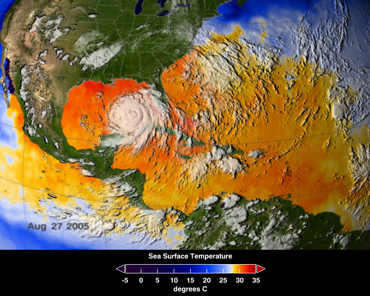 Average sea surface temperatures for the Caribbean Atlantic Ocean (25–27 August 2005).[25] Hurricane Katrina is seen just above Cuba. The climate of the Caribbean is driven by the low latitude and tropical ocean currents that run through it. The principal ocean current is the North Equatorial Current, which enters the region from the tropical Atlantic. The climate of the area is tropical, varying from tropical rainforest in some areas to tropical savanna in others. There are also some locations that are arid climates with considerable drought in some years. Rainfall varies with elevation, size, and water currents (cool upwelling keep the ABC islands arid). Warm, moist trade winds blow consistently from the east, creating both rainforest and semi-arid climates across the region. The tropical rainforest climates include lowland areas near the Caribbean Sea from Costa Rica north to Belize, as well as the Dominican Republic and Puerto Rico, while the more seasonal dry tropical savanna climates are found in Cuba, northern Venezuela, and southern Yucatán, Mexico. Arid climates are found along the extreme northern coast of Venezuela out to the islands including Aruba and Curaçao, as well as the northern tip of Yucatán[26] Tropical cyclones are a threat to the nations that rim the Caribbean Sea. While landfalls are infrequent, the resulting loss of life and property damage makes them a significant hazard to life in the Caribbean. Tropical cyclones that impact the Caribbean often develop off the West coast of Africa and make their way west across the Atlantic Ocean toward the Caribbean, while other storms develop in the Caribbean itself. The Caribbean hurricane season as a whole lasts from June through November, with the majority of hurricanes occurring during August and September. On average around nine tropical storms form each year, with five reaching hurricane strength. According to the National Hurricane Center 385 hurricanes occurred in the Caribbean between 1494 and 1900. |
気候 カリブ海大西洋の平均海面水温(2005年8月25日~27日)[25] ハリケーン・カトリーナがキューバの真上に見える。 カリブ海の気候は、カリブ海を流れる低緯度の熱帯海流によって左右される。主な海流は北赤道海流で、熱帯大西洋からこの地域に流入する。この地域の気候は 熱帯性で、熱帯雨林の地域もあれば、熱帯サバンナの地域もある。また、年によってはかなりの干ばつに見舞われる乾燥気候の場所もある。 降雨量は標高、面積、水流によって異なる(ABC諸島は涼しい湧昇流によって乾燥が保たれている)。暖かく湿った貿易風が一貫して東から吹き、この地域全 体に熱帯雨林気候と半乾燥気候の両方を作り出している。熱帯雨林気候には、コスタリカからベリーズまでのカリブ海に近い低地や、ドミニカ共和国、プエルト リコが含まれ、より季節的な乾燥した熱帯サバンナ気候は、キューバ、ベネズエラ北部、メキシコのユカタン南部に見られる。乾燥気候は、ベネズエラの極北海 岸沿いからアルバ島、キュラソー島、ユカタン半島の北端にかけて見られる[26]。 熱帯低気圧は、カリブ海を囲む国々にとって脅威である。上陸の頻度は低いが、その結果、人命や物的損害が発生するため、カリブ海の生活にとって重大な危険 である。カリブ海に影響を及ぼす熱帯低気圧は、アフリカ西岸沖で発生し、大西洋を西に横断してカリブ海に向かうことが多いが、カリブ海自体で発生するもの もある。カリブ海のハリケーン・シーズンは、全体として6月から11月まで続くが、ハリケーンの大半は8月と9月に発生する。毎年平均して約9つの熱帯性 暴風雨が発生し、そのうち5つがハリケーンの強さに達する。国立ハリケーンセンターによると、1494年から1900年の間に385のハリケーンがカリブ 海で発生した。 |
| Flora and fauna The region has a high level of biodiversity and many species are endemic to the Caribbean. Vegetation The vegetation of the region is mostly tropical but differences in topography, soil and climatic conditions increase species diversity. Where there are porous limestone terraced islands these are generally poor in nutrients. It is estimated that 13,000 species of plants grow in the Caribbean of which 6,500 are endemic. For example, guaiac wood (Guaiacum officinale), the flower of which is the national flower of Jamaica and the Bayahibe rose (Pereskia quisqueyana) which is the national flower of the Dominican Republic and the ceiba which is the national tree of both Puerto Rico and Guatemala. The mahogany is the national tree of the Dominican Republic and Belize. The caimito (Chrysophyllum cainito) grows throughout the Caribbean. In coastal zones there are coconut palms and in lagoons and estuaries are found thick areas of black mangrove and red mangrove (Rhizophora mangle). In shallow water flora and fauna is concentrated around coral reefs where there is little variation in water temperature, purity and salinity. Leeward side of lagoons provide areas of growth for sea grasses. Turtle grass (Thalassia testudinum) is common in the Caribbean as is manatee grass (Syringodium filiforme) which can grow together as well as in fields of single species at depths up to 20 m (66 ft). Another type shoal grass (Halodule wrightii) grows on sand and mud surfaces at depths of up to 5 m (16 ft). In brackish water of harbours and estuaries at depths less than 2.5 m (8 ft 2 in) widgeongrass (Ruppia maritima) grows. Representatives of three species belonging to the genus Halophila, (Halophila baillonii, Halophila engelmannii and Halophila decipiens) are found at depths of up to 30 m (98 ft) except for Halophila engelmani which does not grow below 5 m (16 ft) and is confined to the Bahamas, Florida, the Greater Antilles and the western part of the Caribbean. Halophila baillonii has been found only in the Lesser Antilles.[27] Fauna Puerto Rican parrot Green sea turtle, Grand Cayman Island Marine biota in the region have representatives of both the Indian and Pacific oceans which were caught in the Caribbean before the emergence of the Isthmus of Panama four million years ago.[28] In the Caribbean Sea there are around 1,000 documented species of fish, including sharks (bull shark, tiger shark, silky shark and Caribbean reef shark), flying fish, giant oceanic manta ray, angel fish, spotfin butterflyfish, parrotfish, Atlantic Goliath grouper, tarpon and moray eels. Throughout the Caribbean there is industrial catching of lobster and sardines (off the coast of Yucatán Peninsula). There are 90 species of mammals in the Caribbean including sperm whales, humpback whales and dolphins. The island of Jamaica is home to seals and manatees. The Caribbean monk seal which lived in the Caribbean is considered extinct. Solenodons and hutias are mammals found only in the Caribbean; only one extant species is not endangered. There are 500 species of reptiles (94% of which are endemic). Islands are inhabited by some endemic species such as rock iguanas and American crocodile. The blue iguana, endemic to the island of Grand Cayman, is endangered. The green iguana is invasive to Grand Cayman. The Mona ground iguana which inhabits the island of Mona, Puerto Rico, is endangered. The rhinoceros iguana from the island of Hispaniola which is shared between Haiti and the Dominican Republic is also endangered. The region has several types of sea turtle (loggerhead, green turtle, hawksbill, leatherback turtle, Atlantic ridley and olive ridley). Some species are threatened with extinction.[29] Their populations have been greatly reduced since the 17th century – the number of green turtles has declined from 91 million to 300,000 and hawksbill turtles from 11 million to less than 30,000 by 2006.[30] All 170 species of amphibians that live in the region are endemic. The habitats of almost all members of the toad family, poison dart frogs, tree frogs and leptodactylidae (a type of frog) are limited to only one island.[31] The Golden coqui is in serious threat of extinction. In the Caribbean, 600 species of birds have been recorded, of which 163 are endemic such as todies, Fernandina's flicker and palmchat. The American yellow warbler is found in many areas, as is the green heron. Of the endemic species 48 are threatened with extinction including the Puerto Rican amazon, and the Zapata wren. According to Birdlife International in 2006 in Cuba 29 species of bird are in danger of extinction and two species officially extinct.[32] The black-fronted piping guan is endangered. The Antilles along with Central America lie in the flight path of migrating birds from North America so the size of populations is subject to seasonal fluctuations. Parrots and bananaquits are found in forests. Over the open sea can be seen frigatebirds and tropicbirds. |
植物相と動物相 この地域は生物多様性が高く、多くの種がカリブ海の固有種である。 植生 この地域の植生はほとんどが熱帯性であるが、地形、土壌、気候条件の違いが種の多様性を高めている。多孔質の石灰岩の段々畑がある島は、一般的に栄養分が 乏しい。カリブ海には13,000種の植物が生育していると推定され、そのうち6,500種が固有種である。たとえば、ジャマイカの国花であるグアイアッ クウッド(Guaiacum officinale)、ドミニカ共和国の国花であるバヤヒベバラ(Pereskia quisqueyana)、プエルトリコとグアテマラの国木であるセイバなどである。マホガニーはドミニカ共和国とベリーズの国樹である。カイミト (Chrysophyllum cainito)はカリブ海全域に生育している。沿岸部にはヤシの木があり、ラグーンや河口にはオヒルギやアカヒルギが生い茂る。 浅瀬の動植物は、水温、純度、塩分濃度の変化が少ないサンゴ礁の周辺に集中している。ラグーンの風下側には、海草が生育する場所がある。タートルグラス (Thalassia testudinum)はカリブ海でよく見られ、マナティグラス(Syringodium filiforme)は水深20mまで、単一種だけでなく群生することもある。別の種類の浅瀬草(Halodule wrightii)は、水深5mまでの砂や泥の表面に生える。港湾や河口の汽水域では、水深2.5m以下のところでウィッジグラス(Ruppia maritima)が生育している。Halophila属に属する3種(Halophila baillonii、Halophila engelmannii、Halophila decipiens)の代表的なものは水深30mまで見られるが、Halophila engelmaniは5m以下では生育せず、バハマ、フロリダ、大アンティル諸島、カリブ海西部に限られている。Halophila bailloniiは小アンティルのみで発見されている[27]。 動物相 プエルトリコオウム アオウミガメ、グランドケイマン島 この地域の海洋生物相には、400万年前にパナマ地峡が出現する前にカリブ海で捕獲されたインド洋と太平洋の代表的な生物がいる[28]。カリブ海には、 サメ(オオメジロザメ、イタチザメ、シルキーシャーク、カリビアンリーフシャーク)、トビウオ、巨大なオニイトマキエイ、エンゼルフィッシュ、スポット フィンバタフライフィッシュ、ブダイ、大西洋のゴライアスハタ、ターポン、ウツボなど、記録されている魚類が約1,000種いる。カリブ海全域では、ロブ スターやイワシ(ユカタン半島沖)の産業漁業が行われている。 カリブ海には、マッコウクジラ、ザトウクジラ、イルカなど90種の哺乳類が生息している。ジャマイカ島にはアザラシとマナティーが生息している。カリブ海 に生息していたカリビアンモンクアザラシは絶滅したと考えられている。ソレノドン類とフティア類はカリブ海にのみ生息する哺乳類で、現存する1種だけが絶 滅の危機に瀕していない。 爬虫類は500種(うち94%が固有種)。島々にはロックイグアナやアメリカワニなどの固有種が生息している。グランドケイマン島の固有種であるブルーイ グアナは絶滅の危機に瀕している。グリーンイグアナはグランドケイマンに侵入している。プエルトリコのモナ島に生息するモナグランドイグアナは絶滅危惧種 である。ハイチとドミニカ共和国が共有するイスパニョーラ島に生息するサイ・イグアナも絶滅危惧種である。この地域には数種類のウミガメが生息している (アカウミガメ、アオウミガメ、タイマイ、オサガメ、アトランティック・リドレイ、オリーブ・リドレイ)。アオウミガメの数は9,100万匹から30万匹 に、タイマイは1,100万匹から2006年までに3万匹以下に減少している[30]。 この地域に生息する170種の両生類はすべて固有種です。ヒキガエル科のほぼすべての種、トノサマガエル、アマガエル、レプトダクティル科(カエルの一 種)の生息地は1つの島のみに限られています[31]。 カリブ海では600種の鳥類が記録されており、そのうち163種はトビ、フェルナンディナ・フリッカー、ヤシクイなどの固有種である。アメリカアオムシク イも多くの地域で見られ、アオサギも同様である。固有種のうち48種は絶滅の危機に瀕しており、その中にはプエルトリコのアマゾンやサパタ・ミソサザイが 含まれる。2006年のバードライフ・インターナショナルによると、キューバでは29種の鳥が絶滅の危機に瀕しており、2種が正式に絶滅した。アンティル 諸島は中央アメリカとともに北米からの渡り鳥の飛来経路にあるため、個体数は季節によって変動する。オウムやバナナキッツは森林で見られる。外洋ではフリ ゲート鳥や南国鳥を見ることができる。 |
Economy and human activity A view of San Andrés island, Colombia The Caribbean region has seen a significant increase in human activity since the colonization period. The sea is one of the largest oil production areas in the world, producing approximately 170 million tons[clarification needed] per year.[33] The area also generates a large fishing industry for the surrounding countries, accounting for 500,000 tonnes (490,000 long tons; 550,000 short tons) of fish a year.[34] Human activity in the area also accounts for a significant amount of pollution. The Pan American Health Organization estimated in 1993 that only about 10% of the sewage from the Central American and Caribbean Island countries is properly treated before being released into the sea.[33] The Caribbean region supports a large tourism industry. The Caribbean Tourism Organization calculates that about 12 million people a year visit the area, including (in 1991–1992) about 8 million cruise ship tourists. Tourism based upon scuba diving and snorkeling on coral reefs of many Caribbean islands makes a major contribution to their economies.[35] |
経済と人間活動 コロンビア、サン・アンドレス島の風景 カリブ海地域は、植民地化時代以降、人間活動が著しく活発化している。この海域は世界最大級の石油生産地であり、年間約1億7,000万トン[要出典]を 生産している[33]。また、この地域は周辺諸国にとって大規模な漁業を生み出しており、年間50万トン(長トン49万トン、短トン55万トン)の魚が獲 れる[34]。 この地域における人間の活動も、かなりの量の汚染を引き起こしている。汎米保健機構(Pan American Health Organization)は1993年に、中米およびカリブ海の島国からの下水のうち、海に放流される前に適切に処理されているのは約10%に過ぎない と推定している[33]。 カリブ海地域は、大規模な観光産業を支えている。カリブ海観光機構は、年間約1200万人がこの地域を訪れ、そのうち約800万人(1991~1992 年)がクルーズ船による観光客であると計算している。カリブ海の多くの島々のサンゴ礁でのスキューバダイビングやシュノーケリングに基づく観光は、その経 済に大きく貢献している[35]。 |
| American
Mediterranean Sea Greater Antilles Hispanic America Ibero-America Intra-Americas Sea Kick 'em Jenny Latin America Lesser Antilles List of Caribbean Countries List of Caribbean countries by population Piracy in the Caribbean Territorial evolution of the Caribbean West Indies |
アメリカ地中海 大アンティル諸島 ヒスパニック・アメリカ イベロ・アメリカ アメリカ内海 キック・エム・ジェニー ラテンアメリカ 小アンティル諸島 カリブ海諸国一覧 カリブ海諸国の人口別リスト カリブ海の海賊 カリブ海の領土の変遷 西インド諸島 |
| https://en.wikipedia.org/wiki/Caribbean_Sea |
リ ンク
文 献
そ の他の情報
Copyleft, CC, Mitzub'ixi Quq Chi'j, 1996-2099
![]()
☆
 ☆
☆