パレスチナ地域
Palestine (region)
☆
パレスチナ地方([iii])は、歴史的パレスチナ([1][2][3])とも呼ばれ、西アジアの地理的地域である。現代のイスラエルとパレスチナ、およ
びヨルダン北西部の一部を含む。この地域は、カナン、約束の地、イスラエルの地、または聖地とも呼ばれる。
パレスチナを地理的な地域として言及した最も古い記録は、紀元前5世紀のヘロドトスの『歴史』に見られ、この地域を「パレスチナ」と呼び、紀元前12世紀
から同7世紀までこの地域に存在した国家、ペリシテ人がかつて支配していた領土を指している。ローマ帝国がこの地域を征服し、西暦6年にユダヤ属州を設置
したが、132年のバル・コクバの乱の期間に属州が拡大され、シリア・パレスチナと改名された。[4]
390年のビザンティン時代には、この地域はパレスチナ・プリマ、パレスチナ・セクンダ、パレスチナ・テルティアの3つの属州に分割された。630年代の
イスラム教徒によるレバント征服の後、軍管区ジュンド・フィラスティンが設置された。パレスチナの境界は歴史の中で変化してきたが、概ねシリアやレバント
といった地域の南部を占めてきた。
ユダヤ教とキリスト教の発祥の地であるパレスチナは、宗教、文化、商業、政治の交差点であった。青銅器時代にはカナン人の都市国家が存在し、鉄器時代には
イスラエルとユダ王国が誕生した。その後、新アッシリア帝国、新バビロニア帝国、アケメネス朝ペルシア帝国、マケドニア帝国、セレウコス朝シリアなどのさ
まざまな帝国の支配下に入った。ハスモン朝はローマ帝国に徐々に併合され、その後ビザンチン帝国に併合されて短期間で終焉を迎えた。この間、パレスチナは
キリスト教の中心地となった。7世紀には、パレスチナは正統カリフによって征服され、この地域におけるビザンチン帝国の支配は終焉を迎えた。正統カリフの
支配は、ウマイヤ朝、アッバース朝、ファーティマ朝へと引き継がれた。十字軍遠征によって建国されたエルサレム王国が崩壊した後、パレスチナの人口はイス
ラム教徒が大半を占めるようになった。13世紀にはマムルーク朝の一部となり、1516年以降はオスマン帝国の一部として4世紀を過ごした。
第一次世界大戦中、シナイ・パレスチナ作戦の一環として、パレスチナは英国に占領された。1919年から1922年にかけて、国際連盟はパレスチナ委任統
治領を創設し、1940年代まで委任統治領パレスチナとして英国の統治下に置かれた。ユダヤ人とアラブ人の間の緊張は、1947年から1949年にかけて
のパレスチナ戦争へとエスカレートし、この戦争は、その領土の大半にイスラエルが建国され、ヨルダン川西岸地区とガザ地区はそれぞれ隣接するヨルダンとエ
ジプトが支配することで終結した。1967年の六日戦争では、イスラエルが両地区を占領し、これが現在も続くイスラエル・パレスチナ紛争の主要な問題の一
つとなっている。[5][6][7]
| The region of
Palestine,[iii] also known as historic Palestine,[1][2][3] is a
geographical area in West Asia. It includes modern-day Israel and
Palestine, as well as parts of northwestern Jordan in some definitions.
Other names for the region include Canaan, the Promised Land, the Land
of Israel, or the Holy Land. The earliest written record referring to Palestine as a geographical region is in the Histories of Herodotus in the 5th century BCE, which calls the area Palaistine, referring to the territory previously held by Philistia, a state that existed in that area from the 12th to the 7th century BCE. The Roman Empire conquered the region and in 6 CE established the province known as Judaea, but then in 132 CE in the period of the Bar Kokhba revolt the province was expanded and renamed Syria Palaestina.[4] In 390, during the Byzantine period, the region was split into the provinces of Palaestina Prima, Palaestina Secunda, and Palaestina Tertia. Following the Muslim conquest of the Levant in the 630s, the military district of Jund Filastin was established. While Palestine's boundaries have changed throughout history, it has generally comprised the southern portion of regions such as Syria or the Levant. As the birthplace of Judaism and Christianity, Palestine has been a crossroads for religion, culture, commerce, and politics. In the Bronze Age, it was home to Canaanite city-states; and the later Iron Age saw the emergence of Israel and Judah. It has since come under the sway of various empires, including the Neo-Assyrian Empire, the Neo-Babylonian Empire, the Achaemenid Empire, the Macedonian Empire, and the Seleucid Empire. The brief Hasmonean dynasty ended with its gradual incorporation into the Roman Empire, and later the Byzantine Empire, during which Palestine became a center of Christianity. In the 7th century, Palestine was conquered by the Rashidun Caliphate, ending Byzantine rule in the region; Rashidun rule was succeeded by the Umayyad Caliphate, the Abbasid Caliphate, and the Fatimid Caliphate. Following the collapse of the Kingdom of Jerusalem, which had been established through the Crusades, the population of Palestine became predominantly Muslim. In the 13th century, it became part of the Mamluk Sultanate, and after 1516, spent four centuries as part of the Ottoman Empire. During World War I, Palestine was occupied by the United Kingdom as part of the Sinai and Palestine campaign. Between 1919 and 1922, the League of Nations created the Mandate for Palestine, which came under British administration as Mandatory Palestine through the 1940s. Tensions between Jews and Arabs escalated into the 1947–1949 Palestine war, which ended with the establishment of Israel on most of the territory, and neighboring Jordan and Egypt controlling the West Bank and the Gaza Strip respectively. The 1967 Six-Day War saw Israel's occupation of both territories, which has been among the core issues of the ongoing Israeli–Palestinian conflict.[5][6][7] |
パレスチナ地方([iii])は、歴史的パレスチナ([1][2]
[3])とも呼ばれ、西アジアの地理的地域である。現代のイスラエルとパレスチナ、およびヨルダン北西部の一部を含む。この地域は、カナン、約束の地、イ
スラエルの地、または聖地とも呼ばれる。 パレスチナを地理的な地域として言及した最も古い記録は、紀元前5世紀のヘロドトスの『歴史』に見られ、この地域を「パレスチナ」と呼び、紀元前12世紀 から同7世紀までこの地域に存在した国家、ペリシテ人がかつて支配していた領土を指している。ローマ帝国がこの地域を征服し、西暦6年にユダヤ属州を設置 したが、132年のバル・コクバの乱の期間に属州が拡大され、シリア・パレスチナと改名された。[4] 390年のビザンティン時代には、この地域はパレスチナ・プリマ、パレスチナ・セクンダ、パレスチナ・テルティアの3つの属州に分割された。630年代の イスラム教徒によるレバント征服の後、軍管区ジュンド・フィラスティンが設置された。パレスチナの境界は歴史の中で変化してきたが、概ねシリアやレバント といった地域の南部を占めてきた。 ユダヤ教とキリスト教の発祥の地であるパレスチナは、宗教、文化、商業、政治の交差点であった。青銅器時代にはカナン人の都市国家が存在し、鉄器時代には イスラエルとユダ王国が誕生した。その後、新アッシリア帝国、新バビロニア帝国、アケメネス朝ペルシア帝国、マケドニア帝国、セレウコス朝シリアなどのさ まざまな帝国の支配下に入った。ハスモン朝はローマ帝国に徐々に併合され、その後ビザンチン帝国に併合されて短期間で終焉を迎えた。この間、パレスチナは キリスト教の中心地となった。7世紀には、パレスチナは正統カリフによって征服され、この地域におけるビザンチン帝国の支配は終焉を迎えた。正統カリフの 支配は、ウマイヤ朝、アッバース朝、ファーティマ朝へと引き継がれた。十字軍遠征によって建国されたエルサレム王国が崩壊した後、パレスチナの人口はイス ラム教徒が大半を占めるようになった。13世紀にはマムルーク朝の一部となり、1516年以降はオスマン帝国の一部として4世紀を過ごした。 第一次世界大戦中、シナイ・パレスチナ作戦の一環として、パレスチナは英国に占領された。1919年から1922年にかけて、国際連盟はパレスチナ委任統 治領を創設し、1940年代まで委任統治領パレスチナとして英国の統治下に置かれた。ユダヤ人とアラブ人の間の緊張は、1947年から1949年にかけて のパレスチナ戦争へとエスカレートし、この戦争は、その領土の大半にイスラエルが建国され、ヨルダン川西岸地区とガザ地区はそれぞれ隣接するヨルダンとエ ジプトが支配することで終結した。1967年の六日戦争では、イスラエルが両地区を占領し、これが現在も続くイスラエル・パレスチナ紛争の主要な問題の一 つとなっている。[5][6][7] |
| Etymology For a chronological guide, see Timeline of the name Palestine. 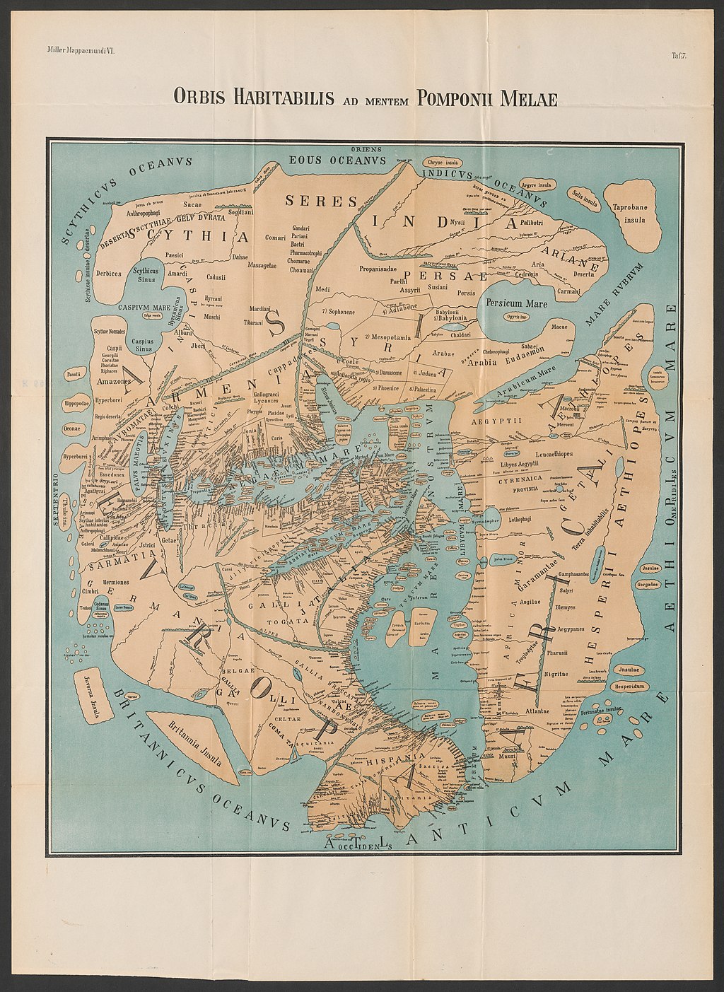 World Map of Pomponius Mela as reconstructed by K. Miller (1898). 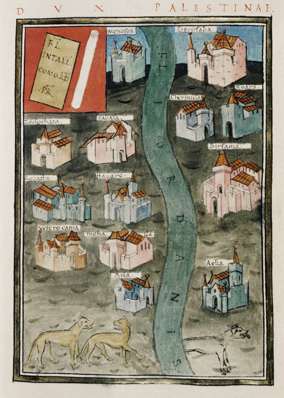 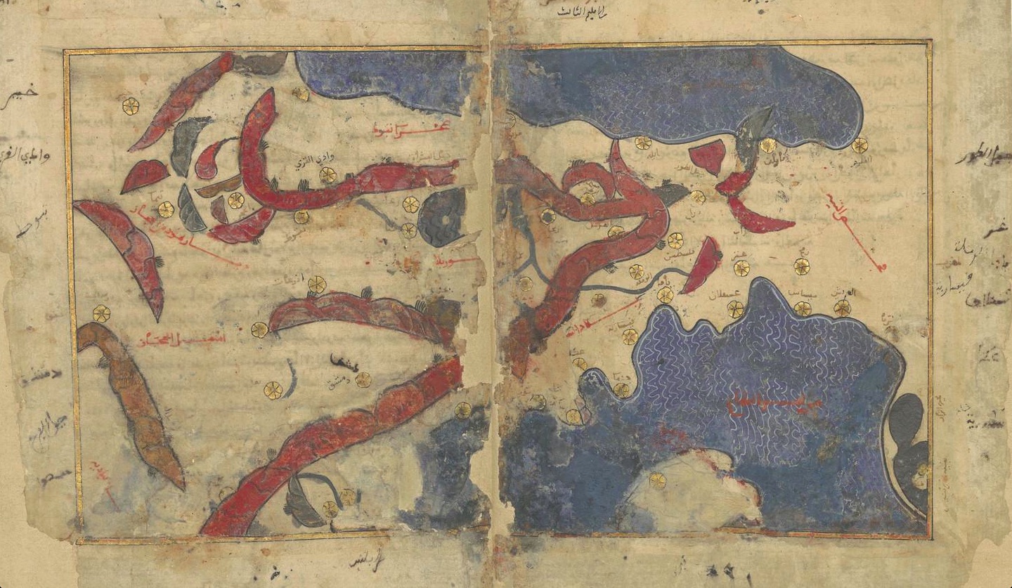 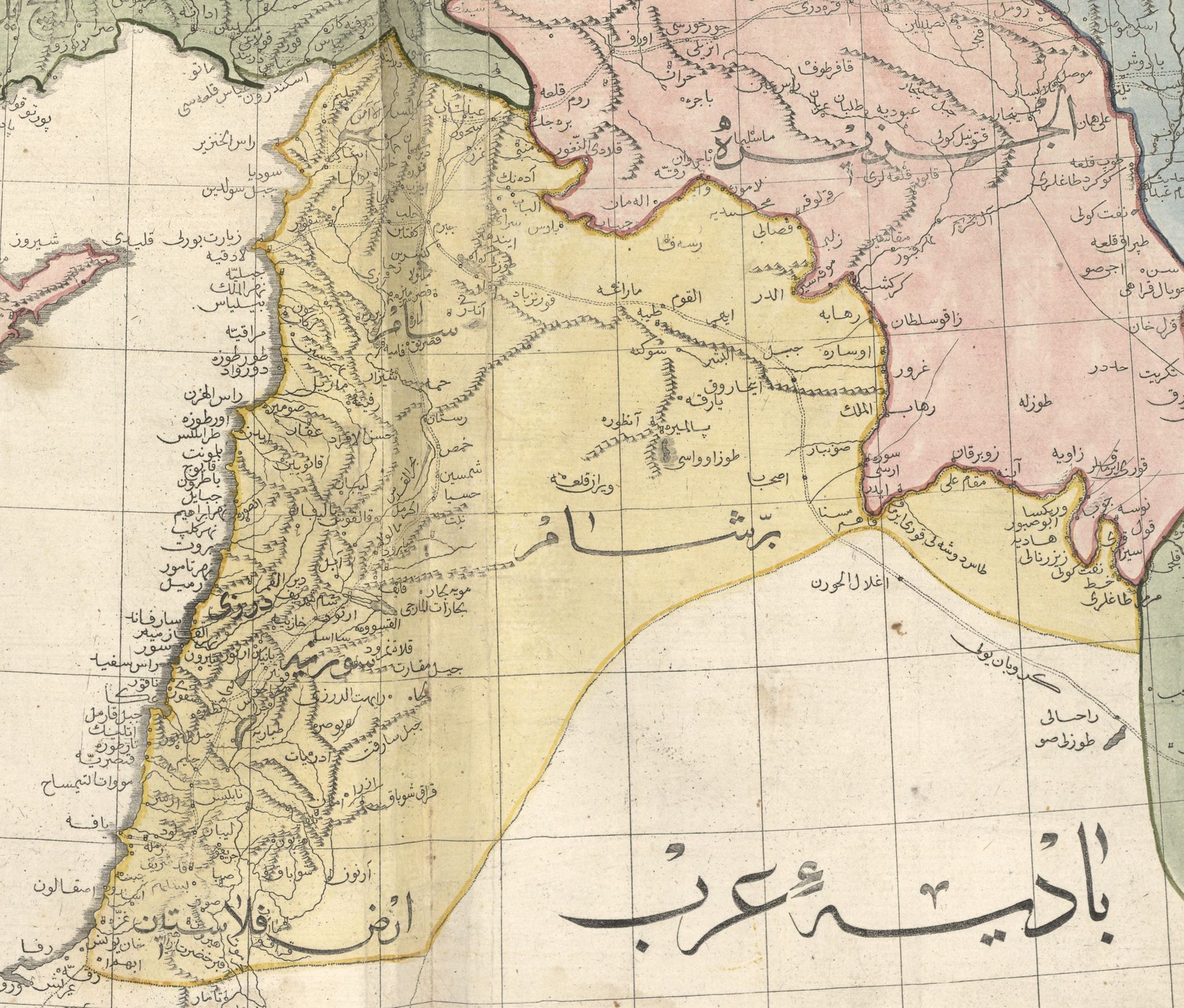 The name is found throughout recorded history. Examples of historical maps of the region that contain the name Palestine are shown above: (1) Pomponius Mela (Latin, c. 43 CE); (2) Notitia Dignitatum (Latin, c. 410 CE); (3) Tabula Rogeriana (Arabic, 1154 CE); (4) Cedid Atlas (Ottoman Turkish, 1803 CE) Modern archaeology has identified 12 ancient inscriptions from Egyptian and Assyrian records recording likely cognates of Hebrew Pelesheth. The term "Peleset" (transliterated from hieroglyphs as P-r-s-t) is found in five inscriptions referring to a neighboring people or land starting from c. 1150 BCE during the Twentieth dynasty of Egypt. The first known mention is at the temple at Medinet Habu which refers to the Peleset among those who fought with Egypt in Ramesses III's reign,[8][9] and the last known is 300 years later on Padiiset's Statue. Seven known Assyrian inscriptions refer to the region of "Palashtu" or "Pilistu", beginning with Adad-nirari III in the Nimrud Slab in c. 800 BCE through to a treaty made by Esarhaddon more than a century later.[10][11] Neither the Egyptian nor the Assyrian sources provided clear regional boundaries for the term.[iv] The first clear use of the term Palestine to refer to the entire area between Phoenicia and Egypt was in 5th century BCE ancient Greece,[v][vi] when Herodotus wrote of a "district of Syria, called Palaistínē" (Ancient Greek: Συρίη ἡ Παλαιστίνη καλεομένη)[12] in The Histories, which included the Judean mountains and the Jordan Rift Valley.[13][vii] Approximately a century later, Aristotle used a similar definition for the region in Meteorology, in which he included the Dead Sea.[14] Later Greek writers such as Polemon and Pausanias also used the term to refer to the same region, which was followed by Roman writers such as Ovid, Tibullus, Pomponius Mela, Pliny the Elder, Dio Chrysostom, Statius, Plutarch as well as Romano-Jewish writers Philo of Alexandria and Josephus.[15][16] The term was first used to denote an official province in c. 135 CE, when the Roman authorities, following the suppression of the Bar Kokhba Revolt, renamed the province of Judaea "Syria Palaestina". There is circumstantial evidence linking Hadrian with the name change,[17] but the precise date is not certain.[17] The term is generally accepted to be a cognate of the biblical name Peleshet (פלשת Pəlésheth, usually transliterated as Philistia). The term and its derivates are used more than 250 times in Masoretic-derived versions of the Hebrew Bible, of which 10 uses are in the Torah, with undefined boundaries, and almost 200 of the remaining references are in the Book of Judges and the Books of Samuel.[10][11][15][18] The term is rarely used in the Septuagint, which used a transliteration Land of Phylistieim (Γῆ τῶν Φυλιστιείμ), different from the contemporary Greek place name Palaistínē (Παλαιστίνη).[19] It is also theorized to be the portmanteau of the Greek word for the Philistines and palaistês, which means "wrestler/rival/adversary".[20] This aligns with the Greek practice of punning place names since the latter is also the etymological meaning for Israel.[21][22][23] The Septuagint instead used the term "allophuloi" (άλλόφυλοι, "other nations") throughout the Books of Judges and Samuel,[24][25] such that the term "Philistines" has been interpreted to mean "non-Israelites of the Promised Land" when used in the context of Samson, Saul and David,[26] and Rabbinic sources explain that these peoples were different from the Philistines of the Book of Genesis.[viii] During the Byzantine period, the region of Palestine within Syria Palaestina was subdivided into Palaestina Prima and Secunda,[27] and an area of land including the Negev and Sinai became Palaestina Salutaris.[27] Following the Muslim conquest, place names that were in use by the Byzantine administration generally continued to be used in Arabic.[10][28] The use of the name "Palestine" became common in Early Modern English,[29] was used in English and Arabic during the Mutasarrifate of Jerusalem[30][31][ix] and was revived as an official place name with the British Mandate for Palestine. Some other terms that have been used to refer to all or part of this land include Canaan, Land of Israel (Eretz Yisrael or Ha'aretz),[33][x][xi] the Promised Land, the region of Syria, the Holy Land, Iudaea Province, Judea, Coele-Syria,[xii] "Israel HaShlema", Kingdom of Israel, Kingdom of Jerusalem, Zion, Retenu (Ancient Egyptian), Southern Syria, Southern Levant and Syria Palaestina. |
語源 年代順のガイドについては、「パレスチナという名称の変遷」を参照のこと。 World Map of Pomponius Mela as reconstructed by K. Miller (1898). この名称は、記録された歴史を通じて見られる。パレスチナという名称が記載されている歴史的な地図の例を以下に示す。(1)ポンポニウス・メラ(ラテン 語、西暦43年頃)、(2)ノティティア・ディグニタータム(ラテン語、西暦410年頃)、(3)タブラ・ロジェリアナ(アラビア語、西暦1154年)、 (4)セディッド・アトラス(オスマン・トルコ語、西暦1803年) 現代の考古学では、ヘブライ語のペレスェト(Pelesheth)の同族語と思われる古代エジプトとアッシリアの記録から12の古代の碑文が特定されてい る。「ペレスェト」(ヒエログリフからP-r-s-tと転写)という用語は、紀元前1150年頃のエジプト第20王朝の時代から、近隣の民族や土地につい て言及した5つの碑文で発見されている。最初に言及されたのは、ラムセス3世の治世下でエジプトと戦った人々の中にペレスエトが言及されているメディネト ハブ神殿である[8][9]。最後に言及されたのは、それから300年後のパディセトの像である。アッシリアの碑文7つが「Palashtu」または 「Pilistu」という地域について言及しており、紀元前800年頃のニムルドの石板に登場するアダド・ニラリ3世から始まり、1世紀以上後のエサルハ ドンによる条約まで続いている。[10][11] エジプトの資料もアッシリアの資料も、この用語の明確な地域境界を示していない。[iv] フェニキアとエジプトの間の地域全体を指す「パレスチナ」という用語が初めて明確に使用されたのは、紀元前5世紀の古代ギリシャにおいてである。[v] [vi] ヘロドトスが『歴史』の中で「パレスチネと呼ばれるシリアの地区」について記述したときである (古代ギリシャ語:Συρίη ἡ Παλαιστίνη καλεομένη)[12]と『歴史』の中で記述し、そこにはユダヤ山脈とヨルダン溝谷が含まれていた。[13][vii] およそ1世紀後、アリストテレスは『気象学』の中で同様の定義をこの地域に対して用い、死海も含めた。 [14] その後、ギリシャの作家であるポレモンやパウサニアスも同じ地域を指すのにこの用語を使用し、さらにローマの作家であるオウィディウス、ティブルス、ポン ポニウス・メラ、大プリニウス、ディオ・クリソストモス、スタティウス、プルタルコス、そしてユダヤ系ローマ人の作家であるアレクサンドリアのフィロンや ヨセフスもこれに続いた。 [15][16] この用語が初めて公式の州を指すために使われたのは、西暦135年頃、ローマ当局がバル・コクバの乱の鎮圧後、ユダヤ州を「シリア・パレスティナ」と改名 したときである。ハドリアヌス帝が名称変更に関与したことを示す状況証拠があるが[17]、正確な日付は不明である。 この用語は、聖書に登場するペレスヘト(Peleshet、通常はPhilistiaと表記される)の同族語であると一般的に受け入れられている。この語 および派生語は、マソラ本文に基づくヘブライ語聖書のバージョンでは250回以上使用されており、そのうち律法では10回使用されているが、境界は明確で はない。残りの参照のほぼ200回は士師記とサムエル記で使用されている。 [10][11][15][18] この用語はセプトゥアギンタではほとんど使用されておらず、現代ギリシャ語の地名パライスティネ(Παλαιστίνη)とは異なる「フィリスティアエム の地」(Γῆ τῶν Φυλιστιείμ)という音訳が使用されている。 [19] また、ギリシア語で「ペリシテ人」を意味する言葉と、「レスラー、ライバル、敵」を意味する「palaistês」を組み合わせた造語であるという説もあ る。[20] 後者は「イスラエル」の語源的意味でもあるため、これはギリシア語の地名の語呂合わせの慣習と一致する。[21][22][23] セプトゥアギンタでは、代わりに「allophuloi」(άλλόφυλοι、「他の民族」)という用語を (άλλόφυλοι、「他の国民」)という用語を、士師記とサムエル記の全体で使用している。[24][25] そのため、「ペリシテ人」という用語は、サムソン、サウル、ダビデの文脈で使用される場合、「約束の地に住む非イスラエル人」を意味すると解釈されてい る。[26] また、ラビの資料では、これらの民族は創世記のペリシテ人とは異なる民族であると説明されている。[viii] ビザンチン帝国時代には、シリア・パレスチナ内のパレスチナ地方はパレスチナ・プリマとパレスチナ・セコンダに細分化され[27]、ネゲブとシナイ半島を 含む地域はパレスチナ・サルタリスとなった[27]。イスラム教徒による征服後、ビザンチン帝国の行政によって使用されていた地名は、概ねアラビア語でも 引き続き使用された。 [10][28] 「パレスチナ」という名称は、初期近代英語で一般的になり[29]、エルサレム総督府時代には英語とアラビア語で使用されていた[30][31] [ix]。そして、パレスチナ委任統治領として公式の地名として復活した。 この土地のすべてまたは一部を指すために使用されてきた他の用語には、カナン、 イスラエルの地(エレツ・イスラエルまたはハ・アレツ)[33][x][xi]、約束の地、シリア地方、聖地、ユダヤ属州、ユダヤ、シリア高原 [xii]、「イスラエル・ハ・シェルマ」、イスラエル王国、エルサレム王国、シオン、レテン(古代エジプト)、南シリア、南レバント、シリア・パレスチ ナなどである。 |
| History Main article: History of Palestine For a chronological guide, see Timeline of the Palestine region. Overview For a more comprehensive list, see Time periods in the Palestine region. Situated at a strategic location between Egypt, Syria and Arabia, and the birthplace of Judaism and Christianity, the region has a long and tumultuous history as a crossroads for religion, culture, commerce, and politics. The region has been controlled by numerous peoples, including ancient Egyptians, Canaanites, Israelites, Assyrians, Babylonians, Achaemenids, ancient Greeks, Romans, Parthians, Sasanians, Byzantines, the Arab Rashidun, Umayyad, Abbasid and Fatimid caliphates, Crusaders, Ayyubids, Mamluks, Mongols, Ottomans, the British, and modern Israelis and Palestinians.[citation needed] |
歴史 詳細は「パレスチナの歴史」を参照 年代順の概略については「パレスチナ地域の年表」を参照 概要 より包括的な一覧については「パレスチナ地域の時代区分」を参照 エジプト、シリア、アラビアの間の戦略的な位置にあり、ユダヤ教とキリスト教の発祥の地でもあるこの地域は、宗教、文化、商業、政治の交差点として、長く 波乱に満ちた歴史を歩んできた。この地域は、古代エジプト人、カナン人、イスラエル人、アッシリア人、バビロニア人、アケメネス朝ペルシア人、古代ギリシ ア人、ローマ人、パルティア人、ササン朝ペルシア人、ビザンチン人、アラブ人の正統カリフ国家、ウマイヤ朝、アッバース朝、ファーティマ朝、十字軍、アイ ユーブ朝、マムルーク朝、モンゴル人、オスマン帝国、英国、そして現代のイスラエル人とパレスチナ人など、数多くの民族によって支配されてきた。 [要出典] |
| Ancient period See also: Canaan, History of ancient Israel and Judah, and Philistines 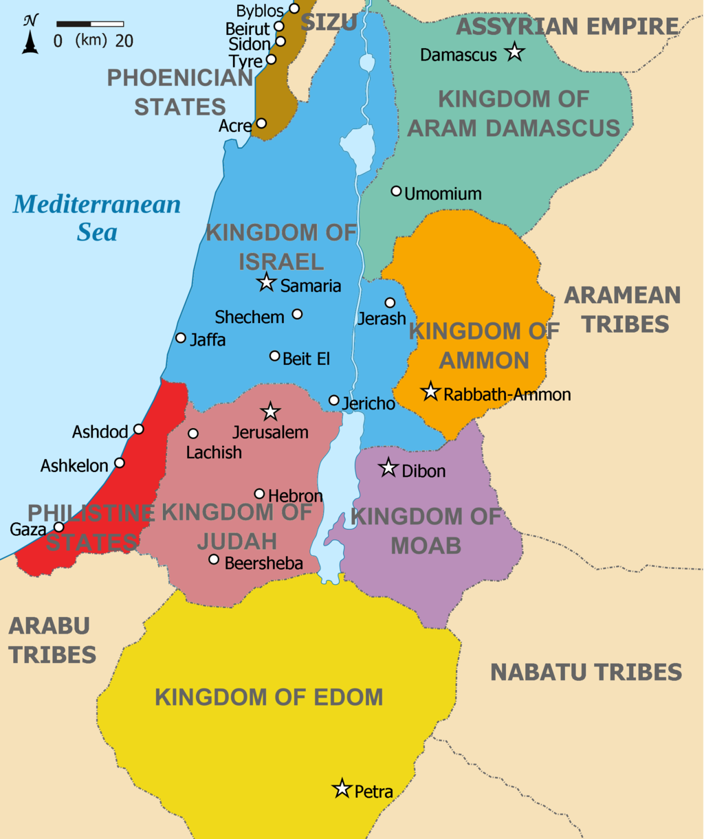 Kingdoms of the Southern Levant during the Iron Age (c. 830 BCE) The region was among the earliest in the world to see human habitation, agricultural communities and civilization.[37] During the Bronze Age, independent Canaanite city-states were established, and were influenced by the surrounding civilizations of ancient Egypt, Mesopotamia, Phoenicia, Minoan Crete, and Syria. Between 1550 and 1400 BCE, the Canaanite cities became vassals to the Egyptian New Kingdom who held power until the 1178 BCE Battle of Djahy (Canaan) during the wider Bronze Age collapse.[38] The Israelites emerged from a dramatic social transformation that took place in the people of the central hill country of Canaan around 1200 BCE, with no signs of violent invasion or even of peaceful infiltration of a clearly defined ethnic group from elsewhere.[39][xiii] During the Iron Age, the Israelites established two related kingdoms, Israel and Judah. The Kingdom of Israel emerged as an important local power by the 10th century BCE before falling to the Neo-Assyrian Empire in 722 BCE. Israel's southern neighbor, the Kingdom of Judah, emerged in the 8th or 9th century BCE and later became a client state of first the Neo-Assyrian and then the Neo-Babylonian Empire before a revolt against the latter led to its destruction in 586 BCE. The region became part of the Neo-Assyrian Empire from c. 740 BCE,[40] which was itself replaced by the Neo-Babylonian Empire in c. 627 BCE.[41] In 587/6 BCE, Jerusalem was besieged and destroyed by the second Babylonian king, Nebuchadnezzar II,[xiv] who subsequently exiled the Judeans to Babylon. The Kingdom of Judah was then annexed as a Babylonian province. The Philistines were also exiled. The defeat of Judah was recorded by the Babylonians.[42][43] In 539 BCE, the Babylonian empire was conquered by the Achaemenid Empire. According to the Hebrew Bible and implications from the Cyrus Cylinder, the exiled Jews were eventually allowed to return to Jerusalem.[44] The returned population in Judah were allowed to self-rule under Persian governance, and some parts of the fallen kingdom became a Persian province known as Yehud.[45][46] Except Yehud, at least another four Persian provinces existed in the region: Samaria, Gaza, Ashdod, and Ascalon, in addition to the Phoenician city states in the north and the Arabian tribes in the south.[47] During the same period, the Edomites migrated from Transjordan to the southern parts of Judea, which became known as Idumaea.[48] The Qedarites were the dominant Arab tribe; their territory ran from the Hejaz in the south to the Negev in the north through the period of Persian and Hellenistic dominion.[49][50] Classical antiquity 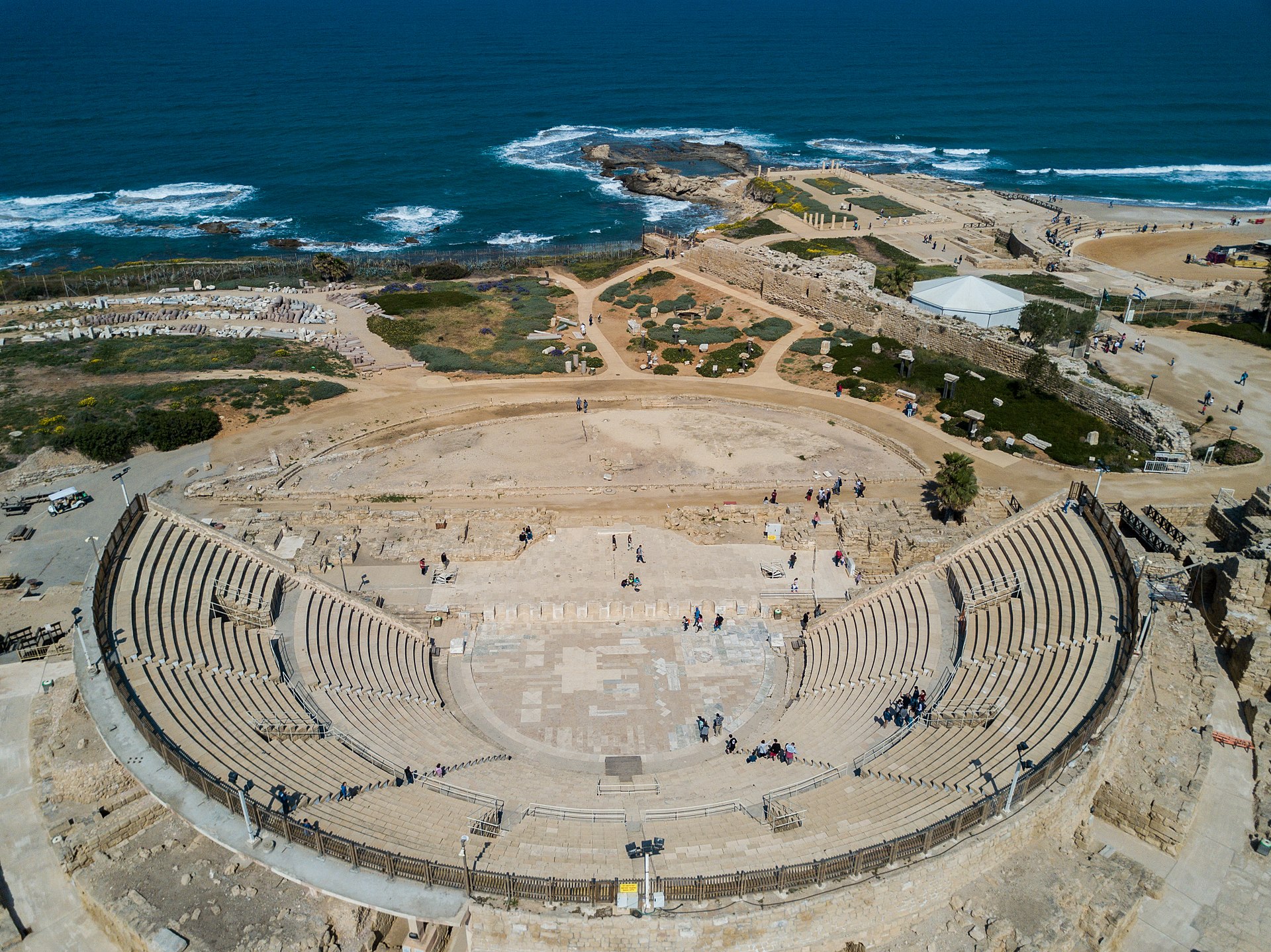 Caesarea Maritima, also known as Caesarea Palestinae, built under Herod the Great at the site of a former Phoenician naval station, became the capital city of Roman Judea, Roman Syria Palaestina and Byzantine Palaestina Prima provinces.[51] In the 330s BCE, Macedonian ruler Alexander the Great conquered the region, which changed hands several times during the wars of the Diadochi and later Syrian Wars. It ultimately fell to the Seleucid Empire between 219 and 200 BCE. During that period, the region became heavily hellenized, building tensions between Greeks and locals. In 167 BCE, the Maccabean Revolt erupted, leading to the establishment of an independent Hasmonean Kingdom in Judea. From 110 BCE, the Hasmoneans extended their authority over much of Palestine, including Samaria, Galilee, Iturea, Perea, and Idumea.[52] The Jewish control over the wider region resulted in it also becoming known as Judaea, a term that had previously only referred to the smaller region of the Judaean Mountains.[xv][53] During the same period, the Edomites were converted to Judaism.[48] Between 73 and 63 BCE, the Roman Republic extended its influence into the region in the Third Mithridatic War. Pompey conquered Judea in 63 BCE, splitting the former Hasmonean Kingdom into five districts. In around 40 BCE, the Parthians conquered Palestine, deposed the Roman ally Hyrcanus II, and installed a puppet ruler of the Hasmonean line known as Antigonus II.[54][55] By 37 BCE, the Parthians withdrew from Palestine.[54] Palestine is generally considered the "Cradle of Christianity".[56][57][58] Christianity, a religion based on the life and teachings of Jesus of Nazareth, arose as a messianic sect from within Second Temple Judaism. The three-year Ministry of Jesus, culminating in his crucifixion, is estimated to have occurred from 28 to 30 CE, although the historicity of Jesus is disputed by a minority of scholars.[xvi]  Model of the Second Temple in Jerusalem, after being rebuilt by Herod. It was destroyed by the Romans in 70 CE during the First Jewish-Roman War.[59] In the first and second centuries CE, the province of Judea became the site of two large-scale Jewish revolts against Rome. During the First Jewish-Roman War, which lasted from 66 to 73 CE, the Romans razed Jerusalem and destroyed the Second Temple.[60] In Masada, Jewish zealots preferred to commit suicide than endure Roman captivity. In 132 CE, another Jewish rebellion erupted. The Bar Kokhba revolt took three years to put down, incurred massive costs on both the Romans and the Jews, and desolated much of Judea.[61][62] The center of Jewish life in Palestine moved to the Galilee.[63] During or after the revolt, Hadrian joined the province of Iudaea with Galilee and the Paralia to form the new province of Syria Palaestina, and Jerusalem was renamed "Aelia Capitolina". Some scholars view these actions as an attempt to disconnect the Jewish people from their homeland,[64][65] but this theory is debated.[19] Between 259 and 272, the region fell under the rule of Odaenathus as King of the Palmyrene Empire. Following the victory of Christian emperor Constantine in the Civil wars of the Tetrarchy, the Christianization of the Roman Empire began, and in 326, Constantine's mother Saint Helena visited Jerusalem and began the construction of churches and shrines. Palestine became a center of Christianity, attracting numerous monks and religious scholars. The Samaritan Revolts during this period caused their near extinction. In 614 CE, Palestine was annexed by another Persian dynasty; the Sassanids, until returning to Byzantine control in 628 CE.[66] |
古代 関連項目:カナン、古代イスラエルとユダの歴史、ペリシテ人 鉄器時代の南レバントの王国(紀元前830年頃) この地域は、世界でも最も早くから人類が居住し、農業社会が形成され、文明が発達した地域であった。青銅器時代には、独立したカナン人の都市国家が建設さ れ、周辺の古代エジプト、メソポタミア、フェニキア、ミノア文明、シリア文明の影響を受けた。紀元前1550年から1400年の間、カナン人の都市はエジ プト新王国の属国となり、より広範な青銅器時代崩壊の過程で紀元前1178年のダハヤ(カナン)の戦いまでその支配は続いた。 イスラエル人は、紀元前1200年頃にカナンの丘陵地帯の中央部で起こった劇的な社会変革から出現した。そこには、他地域から明確に定義された民族集団が 暴力的に侵略した形跡も、平和的に浸透した形跡もなかった。[39][xiii] 鉄器時代に、イスラエル人はイスラエル王国とユダ王国という2つの関連王国を樹立した。イスラエル王国は、紀元前10世紀までに重要な地域大国として台頭 したが、紀元前722年に新アッシリア帝国に滅ぼされた。イスラエルの南に隣接するユダ王国は、紀元前8世紀または9世紀に台頭し、その後、新アッシリア 帝国、次いで新バビロニア帝国の従属国となったが、新バビロニア帝国に対する反乱が紀元前586年の滅亡につながった。この地域は、紀元前740年頃から 新アッシリア帝国の一部となり[40]、新アッシリア帝国は紀元前627年頃に新バビロニア帝国に取って代わられた[41]。 紀元前587年/6年、エルサレムは新バビロニアの第2代王ネブカドネザル2世によって包囲され、破壊された[xiv]。ネブカドネザル2世はその後、ユ ダヤ人をバビロンに追放した。ユダ王国はバビロニアの属州として併合された。 ペリシテ人も追放された。 ユダの敗北はバビロニア人によって記録された。[42][43] 紀元前539年、バビロニア帝国はアケメネス朝ペルシア帝国によって征服された。ヘブライ語聖書とキュロス王の円筒印章の内容によると、追放されていたユ ダヤ人は最終的にエルサレムへの帰還が許された。ユダ王国に帰還した住民はペルシアの統治下で自治を認められ、滅亡した王国の一部はペルシアの属州イェ フードとして知られるようになった。サマリア、ガザ、アシュドッド、アスカロンの4つのペルシア属州が存在し、さらに北部にはフェニキア都市国家、南部に はアラビア部族が存在した。[47] 同じ時期、エドム人はヨルダン川西岸からユダヤの南部に移住し、その地はエドムアとして知られるようになった。 [48] ケダール人は有力なアラブ部族であり、ペルシアとヘレニズムの支配期を通じて、その領土は南のヒジャーズから北のネゲブまで広がっていた。[49] [50] 古典古代 ヘロデ大王の命により、かつてのフェニキア海軍基地の跡地に建設されたカイサリア・マリティマ(別名カイサリア・パレスティネ)は、ローマ領ユダヤ、ローマ領シリア・パレスティナ、ビザンティン領パレスティナ・プリマの首都となった。 紀元前330年代にマケドニアの支配者アレクサンダー大王がこの地域を征服し、その後ディアドコイ戦争やシリア戦争で幾度となく支配者が入れ替わった。最 終的に紀元前219年から200年の間にセレウコス帝国の支配下に入った。この時代にこの地域はヘレニズム化が進み、ギリシア人と地元住民の間に緊張が高 まった。 紀元前167年、マカバイの反乱が勃発し、ユダヤに独立したハスモン朝王国が樹立された。 紀元前110年以降、ハスモン朝はサマリア、ガリラヤ、イトレア、ペレア、エドムを含むパレスチナの大部分にその支配権を拡大した。 [52] ユダヤ人が広域を支配したことにより、ユダヤ山脈の狭い地域のみを指していた「ユダヤ」という名称が、より広い地域をも指すようになった。[xv] [53] 同じ時期に、エドム人もユダヤ教に改宗した。[48] 紀元前73年から63年の間、第三次ミトリダテス戦争においてローマ共和国は同地域に影響力を拡大した。ポンペイウスは紀元前63年にユダヤを征服し、か つてのハスモン朝王国を5つの地区に分割した。紀元前40年頃、パルティア人はパレスチナを征服し、ローマの同盟者であったヒルカノス2世を追放し、アン ティゴノス2世として知られるハスモン朝の傀儡政権を樹立した。[54][55] 紀元前37年までに、パルティア人はパレスチナから撤退した。[54] パレスチナは一般的に「キリスト教発祥の地」と考えられている。[56][57][58] キリスト教は、ナザレのイエスの生涯と教えに基づく宗教であり、第二神殿ユダヤ教の中から救世主的な宗派として生まれた。イエスの3年間の公生涯は、磔刑 に処せられてその頂点を迎えたが、これは西暦28年から30年の間であったと推定されている。ただし、イエスの実在性については、一部の学者の間で異論が ある。[xvi] ヘロデによって再建された後のエルサレムの第二神殿の模型。これは、ユダヤ戦争中の西暦70年にローマ人によって破壊された。[59] 紀元1世紀と2世紀には、ユダヤ州はローマに対する2度の大規模なユダヤ人の反乱の舞台となった。66年から73年まで続いた第一次ユダヤ戦争では、ロー マ軍はエルサレムを破壊し、第二神殿を破壊した。マサダでは、ユダヤ人の狂信者たちはローマの捕虜となることを耐えるよりも自殺することを選んだ。132 年には、またもユダヤ人の反乱が勃発した。バル・コクバの反乱は鎮圧までに3年を要し、ローマ人とユダヤ人の双方に多大な犠牲を強いた。また、ユダヤ人の 多くが住んでいたユダヤ地方の大部分が荒廃した。[61][62] パレスチナにおけるユダヤ人の生活の中心はガリラヤに移った。[63] 反乱中または反乱後に、ハドリアヌス帝はユダヤ地方をガリラヤとパライアと併合し、シリア・パレスチナという新たな属州を形成した。また、エルサレムは 「アエリア・カピトリーナ」と改名された。一部の学者は、これらの行動をユダヤ人たちを彼らの故郷から切り離そうとする試みと見ているが[64] [65]、この説には異論もある[19]。 259年から272年の間、この地域はパルミラ帝国の王オダエナトゥスの支配下に置かれた。キリスト教皇帝コンスタンティヌスが四帝政の内戦で勝利した 後、ローマ帝国のキリスト教化が始まり、326年にはコンスタンティヌスの母である聖ヘレナがエルサレムを訪れ、教会や神殿の建設を開始した。パレスチナ はキリスト教の中心地となり、多数の修道士や宗教学者たちが集まるようになった。この時期に起きたサマリア人の反乱により、彼らは絶滅寸前にまで追い込ま れた。西暦614年、パレスチナは別のペルシア王朝であるササン朝に併合されたが、628年にビザンチン帝国の支配下に戻った。 |
Early Muslim period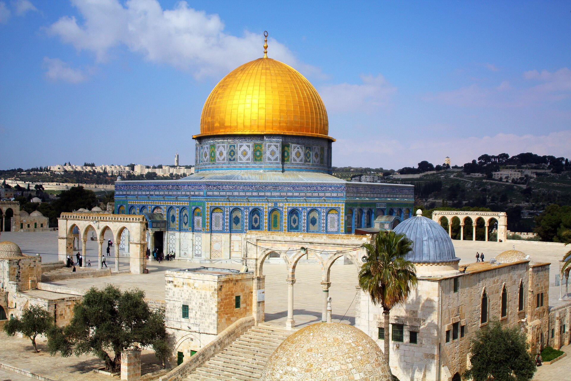 The Dome of the Rock, the world's first great work of Islamic architecture, constructed in 691. 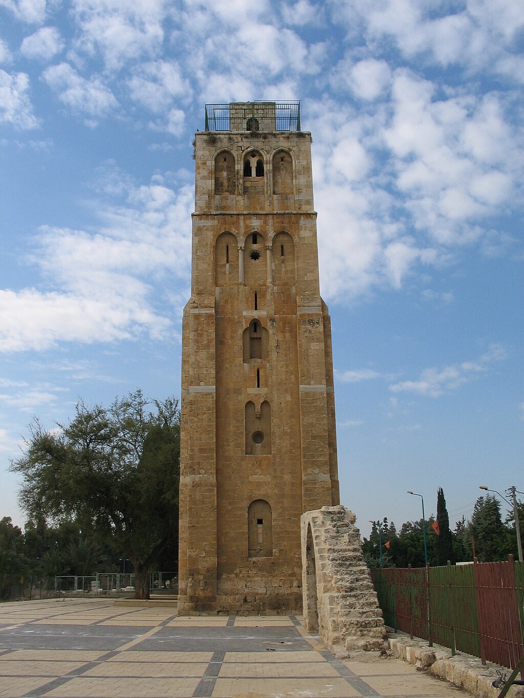 Minaret of the White Mosque in Ramla, constructed in 1318 Arab architecture in the Umayyad and Mamluk periods Palestine was conquered by the Rashidun Caliphate, beginning in 634 CE.[67] In 636, the Battle of Yarmouk during the Muslim conquest of the Levant marked the start of Muslim hegemony over the region, which became known as the military district of Jund Filastin within the province of Bilâd al-Shâm (Greater Syria).[68] In 661, with the Assassination of Ali, Muawiyah I became the Caliph of the Islamic world after being crowned in Jerusalem.[69] The Dome of the Rock, completed in 691, was the world's first great work of Islamic architecture.[70] The majority of the population was Christian and was to remain so until the conquest of Saladin in 1187. The Muslim conquest apparently had little impact on social and administrative continuities for several decades.[71][xvii][72][xviii] The word 'Arab' at the time referred predominantly to Bedouin nomads, though Arab settlement is attested in the Judean highlands and near Jerusalem by the 5th century, and some tribes had converted to Christianity.[73] The local population engaged in farming, which was considered demeaning, and were called Nabaț, referring to Aramaic-speaking villagers. A ḥadīth, brought in the name of a Muslim freedman who settled in Palestine, ordered the Muslim Arabs not to settle in the villages, "for he who abides in villages it is as if he abides in graves".[74] The Umayyads, who had spurred a strong economic resurgence in the area,[75] were replaced by the Abbasids in 750. Ramla became the administrative centre for the following centuries, while Tiberias became a thriving centre of Muslim scholarship.[76] From 878, Palestine was ruled from Egypt by semi-autonomous rulers for almost a century, beginning with the Turkish freeman Ahmad ibn Tulun, for whom both Jews and Christians prayed when he lay dying[77] and ending with the Ikhshidid rulers. Reverence for Jerusalem increased during this period, with many of the Egyptian rulers choosing to be buried there.[xix] However, the later period became characterized by persecution of Christians as the threat from Byzantium grew.[78] The Fatimids, with a predominantly Berber army, conquered the region in 970, a date that marks the beginning of a period of unceasing warfare between numerous enemies, which destroyed Palestine, and in particular, devastating its Jewish population.[79] Between 1071 and 1073, Palestine was captured by the Great Seljuq Empire,[80] only to be recaptured by the Fatimids in 1098.[81] |
イスラム初期 691年に建設された世界初のイスラム建築の大作、岩のドーム。 1318年に建設されたラムラのホワイト・モスクのミナレット ウマイヤ朝時代とマムルーク朝時代のアラブ建築 636年、イスラム教徒のレヴァント征服におけるヤルムークの戦いは、この地域に対するイスラム教徒の覇権の始まりとなった。 [661年、アリーの暗殺により、ムアウィヤ1世がエルサレムで戴冠し、イスラム世界のカリフとなった[69]。691年に完成した岩のドームは、世界初 のイスラム建築の大作となった[70]。 人口の大半はキリスト教徒であり、1187年にサラディンが征服するまでその状態が続いた。当時「アラブ」という言葉は主にベドウィン遊牧民を指していた が、5世紀までにはユダ高地やエルサレム近郊にアラブ人が定住していたことが確認されており、キリスト教に改宗した部族もあった[73]。パレスチナに定 住したムスリムの自由民の名によってもたらされたハディートは、「村に住む者は墓に住むようなものである」として、ムスリムのアラブ人に村に定住しないよ うに命じた[74]。 ウマイヤ朝はこの地域の強力な経済的復活に拍車をかけたが[75]、750年にアッバース朝に取って代わられた。878年以降、パレスチナはほぼ1世紀に わたって半自治的な支配者たちによってエジプトから統治された。トルコ人自由民アフマド・イブン・トゥルンに始まり、彼が死にかけたときにユダヤ教徒もキ リスト教徒も彼のために祈った[77]。この時代にはエルサレムへの崇敬が高まり、エジプトの支配者の多くがエルサレムに埋葬されることを選んだ [xix]。しかし後期には、ビザンチウムの脅威が高まるにつれて、キリスト教徒に対する迫害が特徴的となった。 [1071年から1073年にかけて、パレスチナは大セルジューク帝国に占領され[80]、1098年にファーティミッド帝国に奪還された[81]。 |
Crusader/Ayyubid period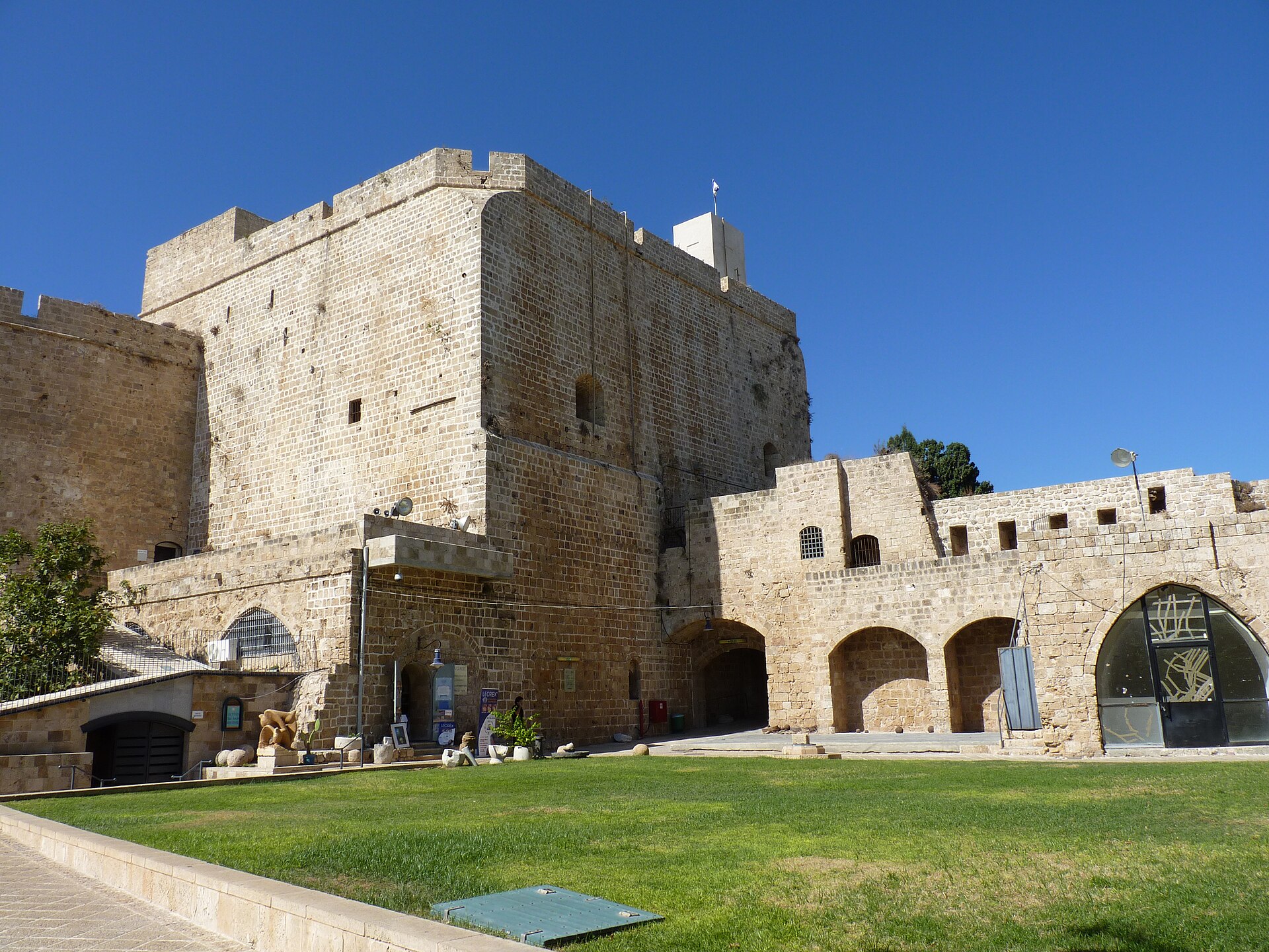 The Hospitaller fortress in Acre was destroyed in 1291 and partially rebuilt in the 18th century. The Fatimids again lost the region to the Crusaders in 1099. The Crusaders set up[82] the Kingdom of Jerusalem (1099–1291).[83] Their control of Jerusalem and most of Palestine lasted almost a century until their defeat by Saladin's forces in 1187,[84] after which most of Palestine was controlled by the Ayyubids,[84] except for the years 1229–1244 when Jerusalem and other areas were retaken[85] by the Second Kingdom of Jerusalem, by then ruled from Acre (1191–1291), but, despite seven further crusades, the Franks were no longer a significant power in the region.[86] The Fourth Crusade, which did not reach Palestine, led directly to the decline of the Byzantine Empire, dramatically reducing Christian influence throughout the region.[87] |
十字軍/アユーブ朝時代 アクレのホスピタラー要塞は1291年に破壊され、18世紀に部分的に再建された。 1099年、ファーティマ朝は再びこの地を十字軍に奪われた。十字軍はエルサレム王国(1099-1291)を樹立した[82]。 [その後、パレスチナの大部分はアユービ朝によって支配され[84]、1229年から1244年にかけてエルサレムとその他の地域は第二エルサレム王国 (1191年から1291年)によって奪還されたが[85]、さらに7回の十字軍が行われたにもかかわらず、フランク王国はもはやこの地域では重要な勢力 ではなかった。 [86]パレスチナに到達しなかった第4回十字軍はビザンチン帝国の衰退に直接つながり、この地域全体のキリスト教の影響力を劇的に減少させた[87]。 |
| Mamluk period The Mamluk Sultanate was created in Egypt as an indirect result of the Seventh Crusade.[88] The Mongol Empire reached Palestine for the first time in 1260, beginning with the Mongol raids into Palestine under Nestorian Christian general Kitbuqa, and reaching an apex at the pivotal Battle of Ain Jalut, where they were pushed back by the Mamluks.[89] |
マムルーク朝時代 第7回十字軍の間接的な結果としてエジプトにマムルーク朝スルタンが誕生した[88]。 モンゴル帝国は1260年に初めてパレスチナに到達し、ネストリウス派キリスト教徒の将軍キトゥブカのパレスチナへのモンゴルの襲撃に始まり、マムルーク 朝に押し戻された極めて重要なアイン・ジャルートの戦いで頂点に達した[89]。 |
| Ottoman period Further information: History of Palestine § Ottoman period In 1486, hostilities broke out between the Mamluks and the Ottoman Empire in a battle for control over western Asia, and the Ottomans conquered Palestine in 1516.[90] Between the mid-16th and 17th centuries, a close-knit alliance of three local dynasties, the Ridwans of Gaza, the Turabays of al-Lajjun and the Farrukhs of Nablus, governed Palestine on behalf of the Porte (imperial Ottoman government).[91] 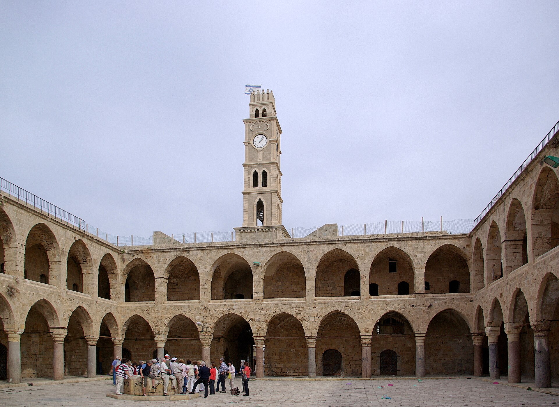 The Khan al-Umdan, constructed in Acre in 1784, is the largest and best preserved caravanserai in the region. In the 18th century, the Zaydani clan under the leadership of Zahir al-Umar ruled large parts of Palestine autonomously[92] until the Ottomans were able to defeat them in their Galilee strongholds in 1775–76.[93] Zahir had turned the port city of Acre into a major regional power, partly fueled by his monopolization of the cotton and olive oil trade from Palestine to Europe. Acre's regional dominance was further elevated under Zahir's successor Ahmad Pasha al-Jazzar at the expense of Damascus.[94] In 1830, on the eve of Muhammad Ali's invasion,[95] the Porte transferred control of the sanjaks of Jerusalem and Nablus to Abdullah Pasha, the governor of Acre. According to Silverburg, in regional and cultural terms this move was important for creating an Arab Palestine detached from greater Syria (bilad al-Sham).[96] According to Pappe, it was an attempt to reinforce the Syrian front in face of Muhammad Ali's invasion.[97] Two years later, Palestine was conquered by Muhammad Ali's Egypt,[95] but Egyptian rule was challenged in 1834 by a countrywide popular uprising against conscription and other measures considered intrusive by the population.[98] Its suppression devastated many of Palestine's villages and major towns.[99] In 1840, Britain intervened and returned control of the Levant to the Ottomans in return for further capitulations.[100] The death of Aqil Agha marked the last local challenge to Ottoman centralization in Palestine,[101] and beginning in the 1860s, Palestine underwent an acceleration in its socio-economic development, due to its incorporation into the global, and particularly European, economic pattern of growth. The beneficiaries of this process were Arabic-speaking Muslims and Christians who emerged as a new layer within the Arab elite.[102] From 1880 large-scale Jewish immigration began, almost entirely from Europe, based on an explicitly Zionist ideology.[citation needed] There was also a revival of the Hebrew language and culture.[xx] Christian Zionism in the United Kingdom preceded its spread within the Jewish community.[103] The government of Great Britain publicly supported it during World War I with the Balfour Declaration of 1917.[104] |
オスマン帝国時代 さらに詳しい情報 パレスチナの歴史§オスマン帝国時代 1486年、西アジアの支配権をめぐってマムルーク朝とオスマン帝国の間で敵対関係が勃発し、オスマン帝国は1516年にパレスチナを征服した[90]。 16世紀半ばから17世紀にかけて、ガザのリドワン朝、アル・ラジュンのトゥラベイ朝、ナブルスのファールーク朝という3つの地方王朝の緊密な同盟が、ポ ルト(オスマン帝国政府)に代わってパレスチナを統治した[91]。 1784年にアクレに建設されたハーン・アル・ウムダンは、この地域で最大かつ最も保存状態の良いキャラバンサライである。 18世紀、ザヒール・アル・ウマル率いるザイダニ一族は、オスマン・トルコが1775年から76年にかけてガリラヤの拠点で彼らを打ち負かすまで、パレス チナの大部分を自治的に支配していた[92]。ザヒールは、パレスチナからヨーロッパへの綿花とオリーブ油の貿易を独占したこともあって、港湾都市アクレ を主要な地域勢力に変えた[93]。ザヒールの後継者アフマド・パシャ・アル・ジャザールのもとで、アクレの地域支配はダマスカスを犠牲にしてさらに高 まった[94]。 1830年、ムハンマド・アリーの侵攻の前夜、ポルトはエルサレムとナブルスのサンジャクの支配権をアクレ総督アブドゥッラー・パシャに譲渡した [95]。シルバーバーグによれば、この動きは地域的・文化的に、大シリア(ビラド・アル・シャーム)から切り離されたアラブ・パレスチナを形成するため に重要であった[96]。パッペによれば、これはムハンマド・アリの侵攻に備えてシリア戦線を強化する試みであった。 [その2年後、パレスチナはムハンマド・アリーのエジプトに征服されたが[95]、エジプトの支配は1834年、徴兵制やその他の住民に押し付けがましい と考えられた施策に反対する全国的な民衆蜂起によって挑戦された[98]。 1840年にはイギリスが介入し、さらなる降伏と引き換えにレバントの支配権をオスマン帝国に返還した[100]。アキール・アッガの死はパレスチナにお けるオスマン帝国の中央集権化に対する最後の地方的な挑戦となり[101]、1860年代からパレスチナは世界的な、特にヨーロッパ的な経済成長パターン に組み込まれることによって、社会経済的な発展の加速化を遂げた。このプロセスの受益者はアラビア語を話すイスラム教徒とキリスト教徒であり、彼らはアラ ブのエリートの中で新たな層として台頭した[102]。1880年からは、ほとんどすべてがヨーロッパからで、明確なシオニズムのイデオロギーに基づく大 規模なユダヤ人移民が始まった[要出典]。ヘブライ語と文化の復興もあった[xx]。 イギリスにおけるキリスト教シオニズムは、ユダヤ人社会におけるシオニズムの広がりに先行していた[103]。 イギリス政府は第一次世界大戦中、1917年のバルフォア宣言によってシオニズムを公に支持した[104]。 |
| British Mandate period Main article: Mandatory Palestine Further information: Zionism, Palestinian nationalism, and United Nations Partition Plan for Palestine 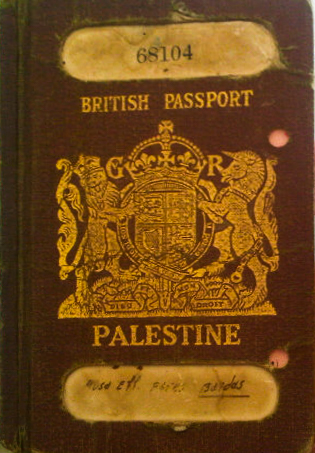 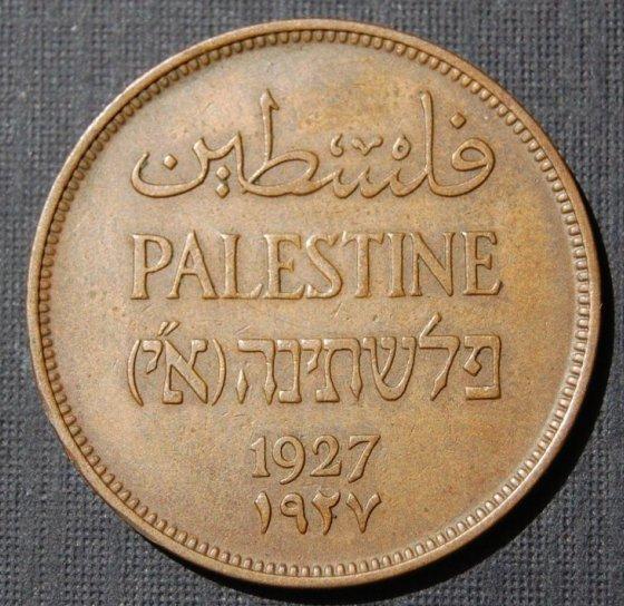 Palestine passport and Palestine coin. The Mandatory authorities agreed a compromise position regarding the Hebrew name: in English and Arabic the name was simply "Palestine" ("فلسطين"), but the Hebrew version ("פלשתינה") also included the acronym ("א״י") for Eretz Yisrael (Land of Israel).  Survey of Palestine 1942–1958 1–100,000 Topographical maps. Click on each blue link to see the individual original maps in high resolution. The British began their Sinai and Palestine Campaign in 1915.[105] The war reached southern Palestine in 1917, progressing to Gaza and around Jerusalem by the end of the year.[105] The British secured Jerusalem in December 1917.[106] They moved into the Jordan valley in 1918 and a campaign by the Entente into northern Palestine led to victory at Megiddo in September.[106] The British were formally awarded the mandate to govern the region in 1922.[107] The Arab Palestinians rioted in 1920, 1921, 1929, and revolted in 1936.[108] In 1947, following World War II and The Holocaust, the British Government announced its desire to terminate the Mandate, and the United Nations General Assembly adopted in November 1947 a Resolution 181(II) recommending partition into an Arab state, a Jewish state and the Special International Regime for the City of Jerusalem.[109] A civil war began immediately after the Resolution's adoption. The State of Israel was declared in May 1948.[110] |
英国委任統治時代 主な記事 委任統治パレスチナ さらに詳しい情報 シオニズム、パレスチナ・ナショナリズム、国連パレスチナ分割計画 パレスチナのパスポートとパレスチナ硬貨。英語とアラビア語では単に「パレスチナ」(「فلسطين」)であったが、ヘブライ語版(「פלשתיה」)にはエレツ・イスラエル(イスラエルの地)の頭文字(「א↪5F4↩י」)も含まれていた。 パレスチナ調査1942-1958 1-100,000地形図。青いリンクをクリックすると高解像度の地図が見られる。 イギリスは1915年にシナイ・パレスチナ作戦を開始した[105]。戦争は1917年にパレスチナ南部に達し、年末までにガザとエルサレム周辺まで進行した[105]。 1920年、1921年、1929年にアラブ系パレスチナ人が暴動を起こし、1936年には反乱を起こした[108]。1947年、第二次世界大戦とホロ コーストの後、イギリス政府は委任統治を終了する意向を表明し、国連総会は1947年11月にアラブ人国家、ユダヤ人国家、エルサレム市のための特別国際 レジームへの分割を勧告する決議181(II)を採択した[109]。イスラエル国家は1948年5月に宣言された[110]。 |
| Arab–Israeli conflict Further information: History of Israel and History of the State of Palestine In the 1948 Arab–Israeli War, Israel captured and incorporated a further 26% of the Mandate territory, Jordan captured the regions of Judea and Samaria,[111][xxi][112] renaming it the "West Bank", while the Gaza Strip was captured by Egypt.[113][114] Following the 1948 Palestinian expulsion and flight, also known as al-Nakba, the 700,000 Palestinians who fled or were driven from their homes were not allowed to return following the Lausanne Conference of 1949.[115] In the course of the Six-Day War in June 1967, Israel captured the rest of Mandate Palestine from Jordan and Egypt, and began a policy of establishing Jewish settlements in those territories. From 1987 to 1993, the First Palestinian Intifada against Israel took place, which included the Declaration of the State of Palestine in 1988 and ended with the 1993 Oslo Peace Accords and the creation of the Palestinian National Authority. In 2000, the Second Intifada (also called al-Aqsa Intifada) began, and Israel built a separation barrier. In the 2005 Israeli disengagement from Gaza, Israel withdrew all settlers and military presence from the Gaza Strip, but maintained military control of numerous aspects of the territory including its borders, air space and coast. Israel's ongoing military occupation of the Gaza Strip, the West Bank and East Jerusalem continues to be the world's longest military occupation in modern times.[xxii][xxiii] In 2008 Palestinian hikaye was inscribed to UNESCO's list of intangible cultural heritage; the first of four listings reflecting the significance of Palestinian culture globally.[126][127] In November 2012, the status of Palestinian delegation in the United Nations was upgraded to non-member observer state as the State of Palestine.[128][xxiv] |
アラブ・イスラエル紛争 さらなる情報 イスラエルの歴史とパレスチナ国家の歴史 1948年のアラブ・イスラエル戦争で、イスラエルは委任統治領のさらに26%を占領・編入し、ヨルダンはユダヤとサマリアの地域を占領し[111] [xxi][112]、「ヨルダン川西岸」と改名し、ガザ地区はエジプトに占領された[113][114]。アル・ナクバとしても知られる1948年のパ レスチナ人の追放と逃亡の後、逃亡したり故郷を追われたりした70万人のパレスチナ人は、1949年のローザンヌ会議後も帰還を許されなかった [115]。 1967年6月の6日間戦争の過程で、イスラエルはヨルダンとエジプトから委任統治領パレスチナの残りを占領し、それらの領土にユダヤ人入植地を建設する 政策を開始した。1987年から1993年にかけて、イスラエルに対する第一次パレスチナ・インティファーダが起こり、1988年のパレスチナ国家宣言を 含み、1993年のオスロ和平合意とパレスチナ国民自治政府の設立で終結した。 2000年には第2次インティファーダ(アル・アクサ・インティファーダとも呼ばれる)が始まり、イスラエルは分離壁を建設した。2005年のイスラエル によるガザ撤退では、イスラエルはガザ地区から入植者と軍事拠点をすべて撤退させたが、国境、空域、海岸を含む領土の多くの側面については軍事支配を維持 した。イスラエルによるガザ地区、ヨルダン川西岸地区、東エルサレムの軍事占領は現在も続いており、近代における世界最長の軍事占領となっている [xxii][xxiii]。 2008年、パレスチナのヒカエはユネスコの無形文化遺産リストに登録された。これはパレスチナ文化の世界的な重要性を反映した4つの登録のうちの最初のものである[126][127]。 2012年11月、国連におけるパレスチナ代表団の地位がパレスチナ国として非加盟オブザーバー国に格上げされた[128][xxiv]。 |
| Boundaries Pre-modern period The boundaries of Palestine have varied throughout history.[xxv][xxvi] The Jordan Rift Valley (comprising Wadi Arabah, the Dead Sea and River Jordan) has at times formed a political and administrative frontier, even within empires that have controlled both territories.[131] At other times, such as during certain periods during the Hasmonean and Crusader states for example, as well as during the biblical period, territories on both sides of the river formed part of the same administrative unit. During the Arab Caliphate period, parts of southern Lebanon and the northern highland areas of Palestine and Jordan were administered as Jund al-Urdun, while the southern parts of the latter two formed part of Jund Dimashq, which during the 9th century was attached to the administrative unit of Jund Filastin.[132] The boundaries of the area and the ethnic nature of the people referred to by Herodotus in the 5th century BCE as Palaestina vary according to context. Sometimes, he uses it to refer to the coast north of Mount Carmel. Elsewhere, distinguishing the Syrians in Palestine from the Phoenicians, he refers to their land as extending down all the coast from Phoenicia to Egypt.[133] Pliny, writing in Latin in the 1st century CE, describes a region of Syria that was "formerly called Palaestina" among the areas of the Eastern Mediterranean.[134] Since the Byzantine Period, the Byzantine borders of Palaestina (I and II, also known as Palaestina Prima, "First Palestine", and Palaestina Secunda, "Second Palestine"), have served as a name for the geographic area between the Jordan River and the Mediterranean Sea. Under Arab rule, Filastin (or Jund Filastin) was used administratively to refer to what was under the Byzantines Palaestina Secunda (comprising Judaea and Samaria), while Palaestina Prima (comprising the Galilee region) was renamed Urdunn ("Jordan" or Jund al-Urdunn).[10] |
境界線 前近代 ヨルダン地溝帯(ワディ・アラバ、死海、ヨルダン川からなる)は、両領土を支配してきた帝国内においても、政治的・行政的な境界を形成することがあった [131]。また、ハスモニア朝や十字軍の時代、聖書の時代など、川の両岸の領土が同じ行政単位を構成することもあった。アラブ・カリフ時代には、レバノ ン南部の一部とパレスチナとヨルダンの北部高地がジュンド・アル=ウルドゥンとして管理され、後者2つの南部はジュンド・ディマシュクの一部を形成してい たが、9世紀にはジュンド・フィラスティンの行政単位に属していた[132]。 前5世紀にヘロドトスがパラエスティナとして言及した地域の境界と人々の民族性は文脈によって異なる。ヘロドトスはカルメル山の北の海岸を指してこの言葉 を使うこともある。紀元前1世紀にラテン語で書かれたプリニウスは、東地中海の地域の中で「以前はパラエスティナと呼ばれていた」シリアの地域を記述して いる[134]。 ビザンチン時代以降、ビザンチン帝国時代の国境であるパラエスティナ(IとII、パラエスティナ・プリマ「第一パレスチナ」とパラエスティナ・セクンダ 「第二パレスチナ」とも呼ばれる)は、ヨルダン川と地中海に挟まれた地理的地域の名称として機能してきた。アラブ人の支配下では、フィラスティン(または ジュンド・フィラスティン)はビザンチン帝国下のパラエスティナ・セクンダ(ユダヤとサマリアから成る)を指すために行政的に使用され、パラエスティナ・ プリマ(ガリラヤ地方から成る)はウルドゥン(「ヨルダン」またはジュンド・アル・ウルドゥン)と改名された[10]。 |
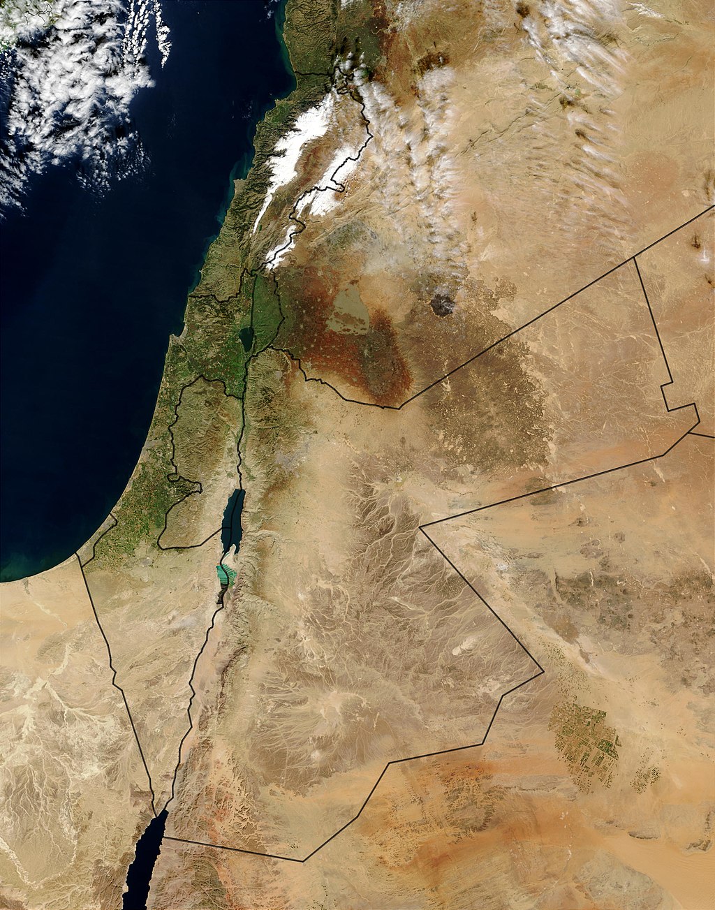
| Modern period Satellite image of the region Nineteenth-century sources refer to Palestine as extending from the sea to the caravan route, presumably the Hejaz-Damascus route east of the Jordan River valley.[135] Others refer to it as extending from the sea to the desert.[135] Prior to the Allied Powers victory in World War I and the partitioning of the Ottoman Empire, which created the British mandate in the Levant, most of the northern area of what is today Jordan formed part of the Ottoman Vilayet of Damascus (Syria), while the southern part of Jordan was part of the Vilayet of Hejaz.[136] What later became Mandatory Palestine was in late Ottoman times divided between the Vilayet of Beirut (Lebanon) and the Sanjak of Jerusalem.[32] The Zionist Organization provided its definition of the boundaries of Palestine in a statement to the Paris Peace Conference in 1919.[137][138] The British administered Mandatory Palestine after World War I, having promised to establish a homeland for the Jewish people. The modern definition of the region follows the boundaries of that entity, which were fixed in the North and East in 1920–23 by the British Mandate for Palestine (including the Transjordan memorandum) and the Paulet–Newcombe Agreement,[33] and on the South by following the 1906 Turco-Egyptian boundary agreement.[139][140] |
近代 衛星写真 19世紀の資料では、パレスチナは海からキャラバンルート(おそらくヨルダン川流域の東にあるヒジャーズ-ダマスカスルート)まで広がっているとされてい る[135]。 [第一次世界大戦で連合国が勝利し、オスマン帝国が分割され、レバントにイギリスの委任統治領が誕生する以前は、現在のヨルダンの北部の大部分はオスマン 帝国のダマスカス(シリア)のヴィライエトの一部であり、ヨルダンの南部はヒジャーズのヴィライエトの一部であった。 [後に委任統治領パレスチナとなるものは、オスマン帝国末期にはベイルート(レバノン)のヴィライエトとエルサレムのサンジャックに分割されていた [32]。シオニスト組織は1919年のパリ講和会議への声明でパレスチナの境界の定義を提示した[137][138]。 第一次世界大戦後、イギリスはユダヤ人のための祖国建設を約束し、委任統治領パレスチナを統治した。この地域の現代的な定義は、1920年から23年にか けてイギリスのパレスチナ委任統治領(トランスヨルダン覚書を含む)とポーレット=ニューコム協定[33]によって北部と東部で確定され、1906年のト ルコ=エジプト境界協定に従って南部で確定された、その実体の境界に従っている[139][140]。 |
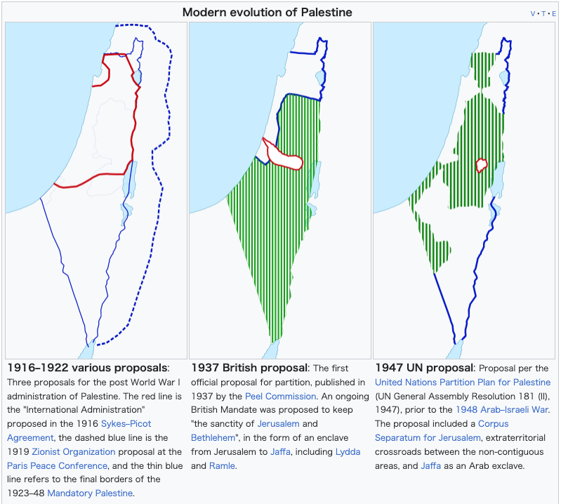 |
1) 1916-1922 様々な提案
第一次世界大戦後のパレスチナ行政に関する3つの提案。赤い線は1916年のサイクス・ピコ協定で提案された「国際行政」、青い破線は1919年のパリ講
和会議でのシオニスト機構の提案、青い細い線は1923年から48年の委任統治パレスチナの最終的な国境線を指す。 2) 1937年 英国の提案 ピール委員会が1937年に発表した最初の公式分割案。エルサレムとベツレヘムの神聖さ」を維持するために、リッダとラムレを含むエルサレムからヤッファまでの飛び地という形で、継続的な英国委任統治が提案された。 3)1947年の国連案: 1948年のアラブ・イスラエル戦争前のパレスチナ分割案(1947年国連総会決議181(II))。この案には、エルサレムの分離領有権、非連続地域間の治外法権的十字路、アラブの飛び地としてのヤッファが含まれていた。 |
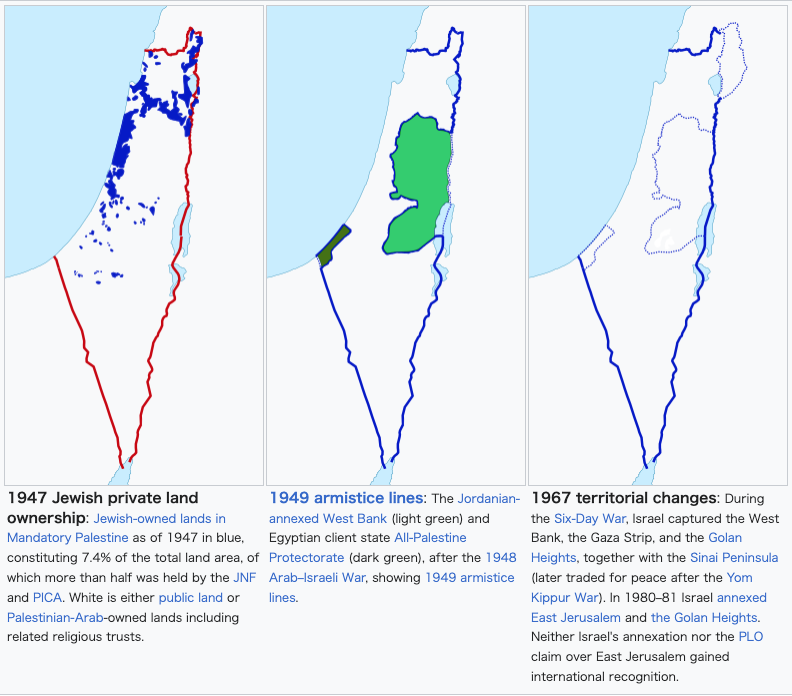 |
4)1947年のユダヤ人の私有地所有:
1947年時点の委任統治領パレスチナにおけるユダヤ人所有地は青色で表示され、土地総面積の7.4%を占め、そのうち半分以上をJNFとPICAが所有
していた。白色は公有地か、関連する宗教信託を含むパレスチナ・アラブ人所有地である。 5)1949年の休戦ライン: 1948年のアラブ・イスラエル戦争後、ヨルダンに併合されたヨルダン川西岸(薄緑)とエジプトの盟主国全パレスチナ保護領(濃緑)。 6)1967年の領土変更: 6日間戦争でイスラエルは、ヨルダン川西岸地区、ガザ地区、ゴラン高原、シナイ半島(後にヨム・キプール戦争後に和平のために交換された)を占領した。 1980年から1981年にかけて、イスラエルは東エルサレムとゴラン高原を併合した。イスラエルの併合もPLOの東エルサレム領有権主張も、国際的には 承認されなかった。 |
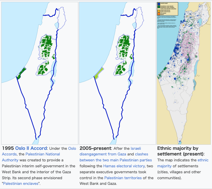 |
7) 1995年 オスロ第2次合意 オスロ合意のもと、パレスチナ自治政府が設立され、ヨルダン川西岸地区とガザ地区内陸部にパレスチナ暫定自治政府が設置された。その第2段階として「パレスチナ人の飛び地」が構想された。 8)2005年から現在に至る: イスラエルによるガザ撤退と、ハマスの選挙勝利に伴うパレスチナの2大政党間の衝突の後、パレスチナ自治区のヨルダン川西岸地区とガザ地区では、2つの行政府が別々に政権を掌握した。 9)居住地別エスニック・マジョリティー(現在) この地図は、居住地(都市、村落、その他のコミュニティ)の民族的多数派を示している。(Demographic_map_of_Palestine_-_Israel_-_with_Legend.png) |
| Current usage Further information: Palestinian territories, State of Palestine, Palestinian National Authority, and Palestinian enclaves See also: Borders of Israel The region of Palestine is the eponym for the Palestinian people and the culture of Palestine, both of which are defined as relating to the whole historical region, usually defined as the localities within the border of Mandatory Palestine. The 1968 Palestinian National Covenant described Palestine as the "homeland of the Arab Palestinian people", with "the boundaries it had during the British Mandate".[141] However, since the 1988 Palestinian Declaration of Independence, the term State of Palestine refers only to the West Bank and the Gaza Strip. This discrepancy was described by the Palestinian president Mahmoud Abbas as a negotiated concession in a September 2011 speech to the United Nations: "... we agreed to establish the State of Palestine on only 22% of the territory of historical Palestine – on all the Palestinian Territory occupied by Israel in 1967."[142] The term Palestine is also sometimes used in a limited sense to refer to the parts of the Palestinian territories currently under the administrative control of the Palestinian National Authority, a quasi-governmental entity which governs parts of the State of Palestine under the terms of the Oslo Accords.[xxviii] |
現在の使用状況 さらなる情報 パレスチナ領土、パレスチナ国家、パレスチナ自治政府、パレスチナの飛び地 以下も参照のこと: イスラエルの国境 パレスチナ地域は、パレスチナ人およびパレスチナ文化の呼称であり、いずれも歴史的地域全体に関するものと定義されている。1968年のパレスチナ国民規 約では、パレスチナは「アラブ系パレスチナ人の祖国」であり、「イギリス委任統治時代の境界線」であるとされていた[141]。 しかし、1988年のパレスチナ独立宣言以降、パレスチナ国家という言葉はヨルダン川西岸地区とガザ地区のみを指している。この矛盾について、パレスチナ のマフムード・アッバス大統領は2011年9月の国連演説で、交渉による譲歩であると述べている: 「1967年にイスラエルによって占領されたすべてのパレスチナ領土において、歴史的パレスチナの22%の領土にのみパレスチナ国家を樹立することに合意 した」[142]。 パレスチナという用語はまた、オスロ合意の条件の下でパレスチナ国家の一部を統治している準政府機関であるパレスチナ自治政府の行政管理下にある現在のパレスチナ領土の一部を指す限定的な意味で使われることもある[xxviii]。 |
| Administration Overview of administration and sovereignty in Israel, the Palestinian territories and the Golan Heights 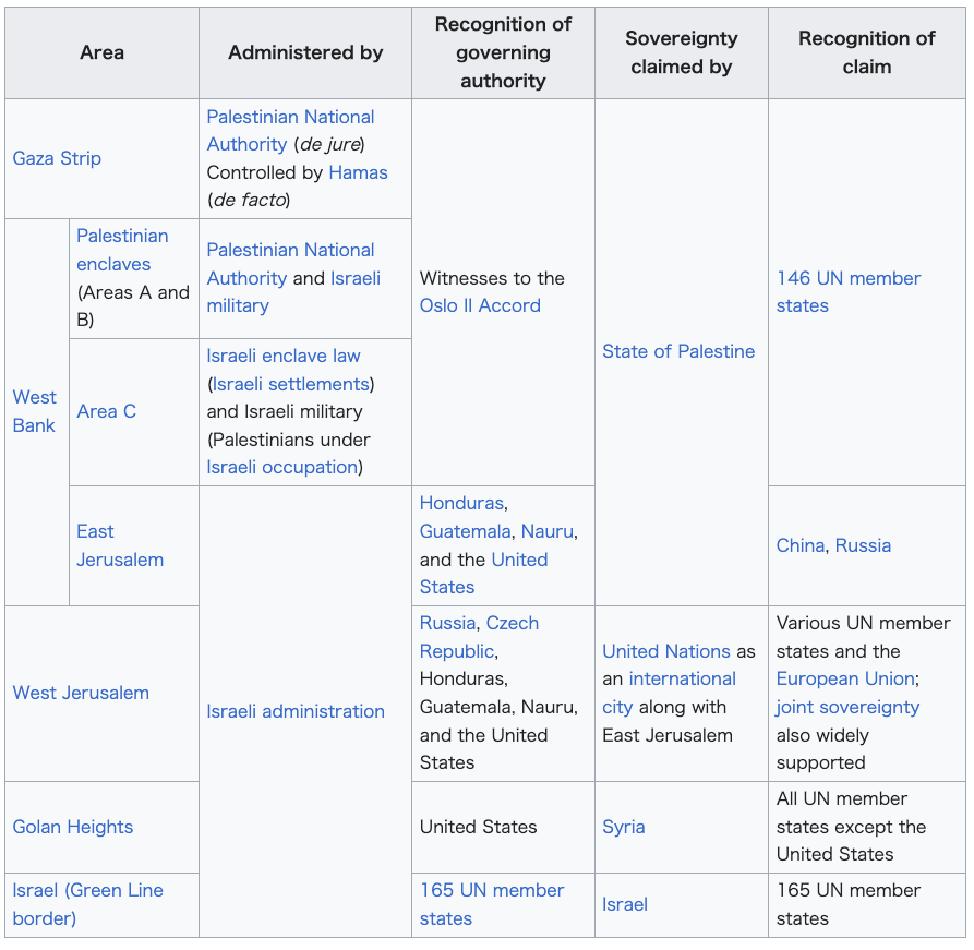 |
行政 イスラエル、パレスチナ自治区、ゴラン高原における行政と主権の概要 |
| Demographics Main article: Demographic history of Palestine Early demographics Estimating the population of Palestine in antiquity relies on two methods – censuses and writings made at the times, and the scientific method based on excavations and statistical methods that consider the number of settlements at the particular age, area of each settlement, density factor for each settlement. The Bar Kokhba revolt in the 2nd century CE saw a major shift in the population of Palestine. The sheer scale and scope of the overall destruction has been described by Dio Cassius in his Roman History, where he notes that Roman war operations in the country had left some 580,000 Jews dead, with many more dying of hunger and disease, while 50 of their most important outposts and 985 of their most famous villages were razed to the ground. "Thus," writes Dio Cassius, "nearly the whole of Judaea was made desolate."[144][145] According to Israeli archaeologists Magen Broshi and Yigal Shiloh, the population of ancient Palestine did not exceed one million.[xxix][xxx] By 300 CE, Christianity had spread so significantly that Jews comprised only a quarter of the population.[xxxi] |
人口統計 主な記事 パレスチナの人口統計 初期の人口統計 古代パレスチナの人口を推計するには、当時の人口調査や文献に基づく方法と、発掘調査や統計学的手法に基づく科学的方法、つまり、その時代の集落数、各集落の面積、各集落の密度係数などを考慮する方法がある。 紀元2世紀のバル・コクバの反乱は、パレスチナの人口に大きな変化をもたらした。ディオ・カッシウスは『ローマ史』の中で、ローマの戦争行為によって約 58万人のユダヤ人が死亡し、さらに多くのユダヤ人が飢えと病気で命を落とし、50の最も重要な前哨地と985の最も有名な村が壊滅したと記している。 「ディオ・カッシウスは「こうして、ユダヤのほぼ全域が荒れ果てた」と書いている[144][145]。 イスラエルの考古学者マゲン・ブロシとイーガル・シローによれば、古代パレスチナの人口は100万人を超えることはなかった[xxix][xxx]。 紀元300年までにはキリスト教が大きく広まったため、ユダヤ人は人口の4分の1しか占めていなかった[xxxi]。 |
| Late Ottoman and British Mandate periods In a study of Ottoman registers of the early Ottoman rule of Palestine, Bernard Lewis reports: [T]he first half century of Ottoman rule brought a sharp increase in population. The towns grew rapidly, villages became larger and more numerous, and there was an extensive development of agriculture, industry, and trade. The two last were certainly helped to no small extent by the influx of Spanish and other Western Jews. From the mass of detail in the registers, it is possible to extract something like a general picture of the economic life of the country in that period. Out of a total population of about 300,000 souls, between a fifth and a quarter lived in the six towns of Jerusalem, Gaza, Safed, Nablus, Ramle, and Hebron. The remainder consisted mainly of peasants, living in villages of varying size, and engaged in agriculture. Their main food-crops were wheat and barley in that order, supplemented by leguminous pulses, olives, fruit, and vegetables. In and around most of the towns there was a considerable number of vineyards, orchards, and vegetable gardens.[146] 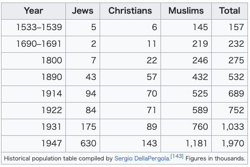 According to Alexander Scholch, the population of Palestine in 1850 was about 350,000 inhabitants, 30% of whom lived in 13 towns; roughly 85% were Muslims, 11% were Christians and 4% Jews.[147] According to Ottoman statistics studied by Justin McCarthy, the population of Palestine in the early 19th century was 350,000, in 1860 it was 411,000 and in 1900 about 600,000 of whom 94% were Arabs.[148] In 1914 Palestine had a population of 657,000 Muslim Arabs, 81,000 Christian Arabs, and 59,000 Jews.[149] McCarthy estimates the non-Jewish population of Palestine at 452,789 in 1882; 737,389 in 1914; 725,507 in 1922; 880,746 in 1931; and 1,339,763 in 1946.[150] In 1920, the League of Nations' Interim Report on the Civil Administration of Palestine described the 700,000 people living in Palestine as follows:[151] Of these, 235,000 live in the larger towns, 465,000 in the smaller towns and villages. Four-fifths of the whole population are Moslems. A small proportion of these are Bedouin Arabs; the remainder, although they speak Arabic and are termed Arabs, are largely of mixed race. Some 77,000 of the population are Christians, in large majority belonging to the Orthodox Church, and speaking Arabic. The minority are members of the Latin or of the Uniate Greek Catholic Church, or—a small number—are Protestants. The Jewish element of the population numbers 76,000. Almost all have entered Palestine during the last 40 years. Prior to 1850, there were in the country only a handful of Jews. In the following 30 years, a few hundreds came to Palestine. Most of them were animated by religious motives; they came to pray and to die in the Holy Land, and to be buried in its soil. After the persecutions in Russia forty years ago, the movement of the Jews to Palestine assumed larger proportions. |
オスマン帝国末期とイギリス委任統治時代 オスマン帝国によるパレスチナ統治初期の登録簿に関する研究の中で、バーナード・ルイスはこう報告している: [オスマン帝国支配の最初の半世紀は、人口の急激な増加をもたらした。町は急速に発展し、村々はより大きく、より多くなり、農業、工業、貿易は広範囲に発展した。この2つは、スペイン人をはじめとする西欧系ユダヤ人の流入に少なからず助けられたことは間違いない。 登録簿の膨大な詳細から、その時期のこの国の経済生活の全体像のようなものを抽出することができる。総人口約30万人のうち、5分の1から4分の1がエル サレム、ガザ、サフェド、ナブルス、ラムレ、ヘブロンの6つの町に住んでいた。残りは主に農民で、大小さまざまな村に住み、農業に従事していた。主な食糧 作物は小麦と大麦の順で、マメ科の豆類、オリーブ、果物、野菜がそれを補っていた。ほとんどの町とその周辺には、かなりの数のブドウ園、果樹園、菜園が あった[146]。 アレクサンダー・ショルヒによれば、1850年のパレスチナの人口は約35万人で、そのうちの30%が13の町に住んでおり、およそ85%がイスラム教徒、11%がキリスト教徒、4%がユダヤ人であった[147]。 ジャスティン・マッカーシーによって研究されたオスマン帝国の統計によれば、19世紀初頭のパレスチナの人口は35万人、1860年には41万1000 人、1900年には約60万人であり、そのうち94%がアラブ人であった。 [マッカーシーはパレスチナの非ユダヤ人人口を1882年には452,789人、1914年には737,389人、1922年には725,507人、 1931年には880,746人、1946年には1,339,763人と推定している[150]。 1920年、パレスチナ市民行政に関する国民連盟の中間報告はパレスチナに住む70万人を次のように記述している[151]。 このうち235,000人が大きな町に、465,000人が小さな町や村に住んでいる。全人口の5分の4がモスレムである。そのうちのごく一部がベドウィ ン系アラブ人であり、残りはアラビア語を話し、アラブ人と呼ばれるが、大部分は混血である。人口のうち77,000人はキリスト教徒で、大多数は正教会に 属し、アラビア語を話す。少数派は、ラテン語またはユニエート・ギリシャ・カトリック教会の信者か、少数だがプロテスタントである。ユダヤ人は 76,000人である。ほぼ全員が過去40年間にパレスチナに移住してきた。1850年以前は、パレスチナにはほんの一握りのユダヤ人しかいなかった。そ の後30年間で、数百人がパレスチナにやってきた。彼らのほとんどは宗教的な動機に動かされ、聖地で祈り、死に、その土に埋葬されるためにやってきた。 40年前のロシアでの迫害の後、パレスチナへのユダヤ人の移動はより大きな割合を占めるようになった。 |
| Current demographics See also: Demographics of Israel and Demographics of the Palestinian territories According to the Israel Central Bureau of Statistics, as of 2015, the total population of Israel was 8.5 million people, of which 75% were Jews, 21% Arabs, and 4% "others".[152] Of the Jewish group, 76% were Sabras (born in Israel); the rest were olim (immigrants)—16% from Europe, the former Soviet republics, and the Americas, and 8% from Asia and Africa, including the Arab countries.[153] According to the Palestinian Central Bureau of Statistics evaluations, in 2015 the Palestinian population of the West Bank was approximately 2.9 million and that of the Gaza Strip was 1.8 million.[154] By 2022, the population of the Gaza strip had increased to an estimated 2,375,259,[155] corresponding to a density of more than 6,507 people per square kilometre. Both Israeli and Palestinian statistics include Arab residents of East Jerusalem in their reports.[156][better source needed] According to these estimates the total population in the region of Palestine, as defined as Israel and the Palestinian territories, stands approximately 12.8 million.[citation needed] |
現在の人口統計 こちらも参照のこと: イスラエルの人口統計、パレスチナ自治区の人口統計 イスラエル中央統計局によると、2015年時点のイスラエルの総人口は850万人で、そのうちユダヤ人が75%、アラブ人が21%、「その他」が4%で あった[152]。ユダヤ人のうち、76%がサブラー(イスラエル生まれ)であり、残りはオリム(移民)で、ヨーロッパ、旧ソビエト共和国、アメリカ大陸 から16%、アラブ諸国を含むアジアとアフリカから8%であった[153]。 パレスチナ中央統計局の評価によると、2015年のヨルダン川西岸のパレスチナ人人口は約290万人、ガザ地区の人口は180万人であった[154]。 2022年までに、ガザ地区の人口は推定237万5,259人に増加し[155]、1平方キロメートル当たり6,507人以上の人口密度に相当する。 イスラエルとパレスチナの統計には、東エルサレムのアラブ系住民も含まれている[156][要出典]。これらの推計によれば、イスラエルとパレスチナ自治区を合わせたパレスチナ地域の総人口は約1,280万人である[要出典]。 |
| Flora and fauna Main article: Biodiversity in Israel and Palestine Flora distribution See also: Category:Flora of Palestine (region) and List of native plants of Flora Palaestina (A–B) The World Geographical Scheme for Recording Plant Distributions is widely used in recording the distribution of plants. The scheme uses the code "PAL" to refer to the region of Palestine – a Level 3 area. The WGSRPD's Palestine is further divided into Israel (PAL-IS), including the Palestinian territories, and Jordan (PAL-JO), so is larger than some other definitions of "Palestine".[157] Birds Main article: List of birds of Palestine |
植物相と動物相 主な記事 イスラエルとパレスチナの生物多様性 植物相の分布 こちらも参照のこと: カテゴリー:Flora of Palestine (region) and List of native plants of Flora Palaestina (A-B) 植物の分布の記録には、世界地理スキーム(World Geographical Scheme for Recording Plant Distributions)が広く使われている。このスキームでは、レベル3の地域であるパレスチナを 「PAL 」というコードで表記している。WGSRPDのパレスチナは、パレスチナ自治区を含むイスラエル(PAL-IS)とヨルダン(PAL-JO)にさらに分割 されているため、他の「パレスチナ」の定義よりも大きい[157]。 鳥類 主な記事 パレスチナの鳥類のリスト |
| https://en.wikipedia.org/wiki/Palestine_(region) |
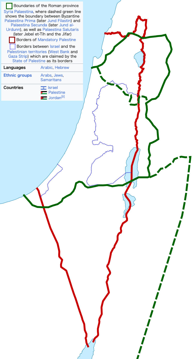
【緑
の実線と破線】ローマ帝国の属州シリア・パレスチナの境界。破線の緑線は、ビザンチン帝国のパレスチナ・プリマ(後のジュンド・フィラスティン)とパレス
チナ・セコンダ(後のジュンド・アル・ウルドゥン)の境界、およびパレスチナ・サルータリス(後のジェベル・エト・ティとジファール)の境界を示してい
る。
【赤の実線】パレスチナ委任統治領の境界線
【青の小さい破線】パレスチナ国家が自国の境界線と主張しているイスラエルとパレスチナ自治区(ヨルダン川西岸地区およびガザ地区)の境界線
リ ンク
文 献
そ の他の情報
CC
Copyleft,
CC, Mitzub'ixi Quq Chi'j, 1996-2099