グアテマラの征服
Conquista de Guatemala
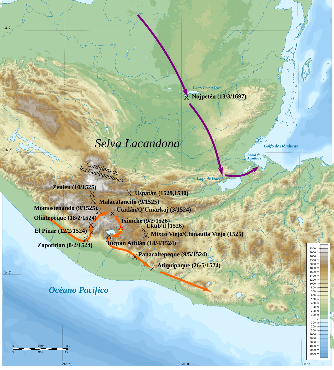
グアテマラ征服の主な進入ルートと戦闘地の地図
☆ グアテマラ征服(conquista de Guatemala)は、現在の中央アメリカ、グアテマラ共和国の領土におけるスペインのアメリカ大陸植民地化の一環である紛争である。征服以前、この領土はメ ソアメリカのいくつかの王国から成っており、そのほとんどはマヤ文明に属していた。マヤとスペインの探検家との最初の接触は16世紀に起こった。1511 年、パナマからサント・ドミンゴに向かうスペイン船がユカタン半島の東海岸で難破したのである。スペイン帝国への統合に対するマヤ王国の粘り強い抵抗のた めである。ペドロ・デ・アルバラドは1524年初頭、スペイン人征服者とその同盟者、主にトラスカラとチョルーラ出身の先住民からなる混成部隊の指揮官としてグアテ マラに到着した。グアテマラ全土の地名にナワトル語の地名があるのは、スペイン人の案内役や翻訳役も務めたこれらメキシコ人の同盟者の影響によるものであ る。3 カクチケル族も彼らに加わった。一方、他の高地マヤ王国は、スペインとその同盟国であるメキシコの戦士たち、および以前服従していたマヤ王国の戦士たちに よって、それぞれ敗北していた。イツァ族とペテン盆地の他の低地マヤ民族は1525年にエルナン・コルテスと初めて接触したが、イツァ王国はスペインの侵 略に敵対し、1697年まで独立を維持した(→スペイン語版からの翻訳「グアテマラの征服」)。
| Spanish conquest of Guatemala In a protracted conflict during the Spanish colonization of the Americas, Spanish colonisers gradually incorporated the territory that became the modern country of Guatemala into the colonial Viceroyalty of New Spain. Before the conquest, this territory contained a number of competing Mesoamerican kingdoms, the majority of which were Maya. Many conquistadors viewed the Maya as "infidels" who needed to be forcefully converted and pacified, disregarding the achievements of their civilization.[2] The first contact between the Maya and European explorers came in the early 16th century when a Spanish ship sailing from Panama to Santo Domingo was wrecked on the east coast of the Yucatán Peninsula in 1511.[2] Several Spanish expeditions followed in 1517 and 1519, making landfall on various parts of the Yucatán coast.[3] The Spanish conquest of the Maya was a prolonged affair; the Maya kingdoms resisted integration into the Spanish Empire with such tenacity that their defeat took almost two centuries.[4] Pedro de Alvarado arrived in Guatemala from the newly conquered Mexico in early 1524, commanding a mixed force of Spanish conquistadors and native allies, mostly from Tlaxcala and Cholula. Geographic features across Guatemala now bear Nahuatl placenames owing to the influence of these Mexican allies, who translated for the Spanish.[5] The Kaqchikel Maya initially allied themselves with the Spanish, but soon rebelled against excessive demands for tribute and did not finally surrender until 1530. In the meantime the other major highland Maya kingdoms had each been defeated in turn by the Spanish and allied warriors from Mexico and already subjugated Maya kingdoms in Guatemala. The Itza Maya and other lowland groups in the Petén Basin were first contacted by Hernán Cortés in 1525, but remained independent and hostile to the encroaching Spanish until 1697, when a concerted Spanish assault led by Martín de Ursúa y Arizmendi finally defeated the last independent Maya kingdom. Spanish and native tactics and technology differed greatly. The Spanish viewed the taking of prisoners as a hindrance to outright victory, whereas the Maya prioritised the capture of live prisoners and of booty. The indigenous peoples of Guatemala lacked key elements of Old World technology such as a functional wheel, horses, iron, steel, and gunpowder; they were also extremely susceptible to Old World diseases, against which they had no resistance. The Maya preferred raiding and ambush to large-scale warfare, using spears, arrows and wooden swords with inset obsidian blades; the Xinca of the southern coastal plain used poison on their arrows. In response to the use of Spanish cavalry, the highland Maya took to digging pits and lining them with wooden stakes. |
スペインによるグアテマラの征服(Spanish conquest of Guatemala) スペインによるアメリカ大陸の植民地化に伴う長期にわたる紛争の中で、スペインの植民者たちは、現在のグアテマラ国となる領土を徐々に植民地総督領 ニュー・スペインに組み込んでいった。征服以前、この領土には多くの競合するメソアメリカ王国が存在し、その大半はマヤ族が支配していた。多くの征服者は マヤ人を「異教徒」と見なし、彼らの文明の偉業を無視して、強制的に改宗させ、平定する必要があると考えていた[2]。マヤ人とヨーロッパ人探検家との最 初の接触は、16世紀初頭にパナマからサントドミンゴへ向かっていたスペイン船が、1511年にユカタン半島東海岸で難破したときに起こった[2]。その 後、1517年と1519年にスペインの探検隊が続き、 1519年には、ユカタン半島のさまざまな場所に上陸した[3]。スペインによるマヤ征服は長期にわたる戦いとなり、マヤ王国はスペイン帝国への統合に頑 強に抵抗し、その敗北には約2世紀を要した[4]。 ペドロ・デ・アルバラードは、1524年初頭に新たに征服したメキシコからグアテマラに到着し、スペインの征服者と、トラスカラやチョルーラ出身の先住民 同盟軍からなる混成部隊を指揮した。グアテマラ全土の地理的名称は、スペイン語に通訳したこれらのメキシコ同盟者の影響により、ナワトル語に由来する地名 となっている[5]。カクチケル・マヤ族は当初スペインと同盟を結んだが、すぐに過度な貢納金の要求に反発し、最終的に降伏したのは1530年になってか らだった。その間、他の主要な高地マヤ王国は、メキシコからの同盟戦士とスペイン軍に次々と敗れ、すでに征服されていたグアテマラのマヤ王国に服従してい た。ペテン盆地のイツァ・マヤ族やその他の低地に住むグループは、1525年にエルナン・コルテスと初めて接触したが、1697年にスペイン軍がマルティ ン・デ・ウルスーア・イ・アリスメンド率いる総攻撃をしかけるまで、スペインの侵略に抵抗し、独立を維持していた。 スペイン人と先住民は戦術や技術が大きく異なっていた。スペイン人は捕虜の捕獲を完全な勝利への障害とみなしていたが、マヤ人は生きた捕虜と戦利品の捕獲 を優先していた。グアテマラの先住民は、機能的な車輪、馬、鉄、鋼鉄、火薬といった旧世界の技術に不可欠な要素を欠いており、旧世界の病気にも非常に弱 かったが、それに対する抵抗力はなかった。マヤ族は、槍や矢、黒曜石を埋め込んだ木の剣などを用いて、大規模な戦争よりも奇襲や待ち伏せを好んだ。一方、 南部の平野地帯に住むシンカ族は、矢に毒を塗っていた。スペイン騎兵隊の攻撃に対抗するため、高地に住むマヤ族は穴を掘って木の杭を並べた。 |
Historical sources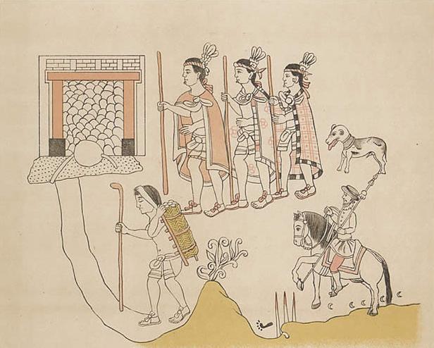 Painting with three prominent indigenous warriors in single file facing left, wearing cloaks and grasping staves, followed by a dog. Below them and to the right is the smaller image of a mounted Spaniard with a raised lance. To the left and indigenous porter carries a pack fixed by a strap across his forehead, and sports a staff in one hand. All are apparently moving towards a doorway at top left. A page from the Lienzo de Tlaxcala, showing a Spanish conquistador accompanied by Tlaxcalan allies and a native porter The sources describing the Spanish conquest of Guatemala include those written by the Spanish themselves, among them two of four letters written by conquistador Pedro de Alvarado to Hernán Cortés in 1524, describing the initial campaign to subjugate the Guatemalan Highlands. These letters were despatched to Tenochtitlan, addressed to Cortés but with a royal audience in mind; two of these letters are now lost.[6] Gonzalo de Alvarado y Chávez was Pedro de Alvarado's cousin; he accompanied him on his first campaign in Guatemala and in 1525 he became the chief constable of Santiago de los Caballeros de Guatemala, the newly founded Spanish capital. Gonzalo wrote an account that mostly supports that of Pedro de Alvarado. Pedro de Alvarado's brother Jorge wrote another account to the king of Spain that explained it was his own campaign of 1527–1529 that established the Spanish colony.[7] Bernal Díaz del Castillo wrote a lengthy account of the conquest of Mexico and neighbouring regions, the Historia verdadera de la conquista de la Nueva España ("True History of the Conquest of New Spain"); his account of the conquest of Guatemala generally agrees with that of the Alvarados.[8] His account was finished around 1568, some 40 years after the campaigns it describes.[9] Hernán Cortés described his expedition to Honduras in the fifth letter of his Cartas de Relación,[10] in which he details his crossing of what is now Guatemala's Petén Department. Dominican friar Bartolomé de las Casas wrote a highly critical account of the Spanish conquest of the Americas and included accounts of some incidents in Guatemala.[11] The Brevísima Relación de la Destrucción de las Indias ("Short Account of the Destruction of the Indies") was first published in 1552 in Seville.[12] The Tlaxcalan allies of the Spanish who accompanied them in their invasion of Guatemala wrote their own accounts of the conquest; these included a letter to the Spanish king protesting at their poor treatment once the campaign was over. Other accounts were in the form of questionnaires answered before colonial magistrates to protest and register a claim for recompense.[13] Two pictorial accounts painted in the stylised indigenous pictographic tradition have survived; these are the Lienzo de Quauhquechollan, which was probably painted in Ciudad Vieja in the 1530s, and the Lienzo de Tlaxcala, painted in Tlaxcala.[14] Accounts of the conquest as seen from the point of view of the defeated highland Maya kingdoms are included in a number of indigenous documents, including the Annals of the Kaqchikels, which includes the Xajil Chronicle describing the history of the Kaqchikel from their mythical creation down through the Spanish conquest and continuing to 1619.[15] A letter from the defeated Tzʼutujil Maya nobility of Santiago Atitlán to the Spanish king written in 1571 details the exploitation of the subjugated peoples.[16] Francisco Antonio de Fuentes y Guzmán was a colonial Guatemalan historian of Spanish descent who wrote La Recordación Florida, also called Historia de Guatemala (History of Guatemala). The book was written in 1690 and is regarded as one of the most important works of Guatemalan history, and is the first such book to have been written by a criollo author.[17] Field investigation has tended to support the estimates of indigenous population and army sizes given by Fuentes y Guzmán.[18] |
歴史的資料 左向きに並んだ3人の先住民族の戦士が、マントを身にまとい、杖を握り、その後に犬が続いている。彼らの下、右側には、槍を構えた騎馬スペイン人の小さな 絵が描かれている。左側には先住民族のポーターが、額にストラップで固定した荷物を背負い、片手に杖を持っている。全員が左上のドアに向かって歩いている ようだ。 スペインの征服者、トラスカラ人の同盟者、先住民のポーターが一緒に描かれた「トラスカラ図」のページ スペインによるグアテマラ征服について書かれた資料には、スペイン人自身によるものも含まれる。その中には、征服者ペドロ・デ・アルバラドが1524年に エルナン・コルテスに宛てた4通の手紙のうちの2通があり、グアテマラ高地を征服するための最初のキャンペーンについて述べている。これらの手紙は、コル テス宛てにテノチティトランに送られたが、王の謁見を想定したものであった。これらの手紙のうち2通は現在紛失している[6]。ゴンサロ・デ・アルバラ ド・イ・チャベスは、ペドロ・デ・アルバラドの従兄弟であり、グアテマラでの最初の遠征に同行し、1525年には新たにスペインの首都となったサンティア ゴ・デ・ロス・カバリェロス・デ・グアテマラの最高憲兵となった。ゴンサロは、ペドロ・デ・アルバラドの記述をほぼ裏付ける内容の報告書を書き上げた。ペ ドロ・デ・アルバラドの弟ホルヘは、スペイン王に宛てて、スペイン植民地が確立したのは1527年から1529年にかけての自身の遠征によるものであると 説明した別の記録を残している[7]。ベルナル・ディアス・デル・カスティージョは、メキシコと近隣の地域の征服について長編『ヌエバ・エスパーニャ征服 史』(Historia verdadera de la conquista de la Nueva España)を著した。グアテマラ征服に関する記述は、アルヴァラド家の記述と概ね一致している[8]。彼の記述は、1568年頃に完成した。これは、 記述されている遠征から40年ほど後のことである[9]。エルナン・コルテスは、Cartas de Relación(関係の手紙)の第5の手紙でホンジュラスへの遠征について述べている[10]。この手紙では、現在のグアテマラのペテン県を横断したと きの詳細が述べられている。ドミニコ会の修道士バルトロメ・デ・ラス・カサス(Bartolomé de las Casas)は、スペインによるアメリカ大陸征服について非常に批判的な記述を残しており、グアテマラでのいくつかの事件についても触れている[11]。 『Brevísima Relación de la Destrucción de las Indias』(「インド諸国の破壊に関する簡潔な記述」)は 1552年にセビリアで初めて出版された[12]。 スペインの同盟国であるトラスカラン族は、グアテマラ侵攻に同行し、スペイン王に宛てた手紙で、侵攻後の劣悪な待遇に抗議するなど、自らの征服体験を記録 した。その他の記録は、植民地時代の判事の前で回答するアンケート形式になっており、抗議と賠償請求を登録するものだった[13]。2つの絵画記録が、様 式化された先住民の絵文字の伝統で描かれ、現存している。これらは、1530年代にシウダー・ビエハで描かれたと思われる「Lienzo de Quauhquechollan」と、トラスカラで描かれた「Lienzo de Tlaxcala」である[14]。トラスカラで描かれたものである[14]。 征服について、敗北した高地マヤ王国から見た記録は、先住民の文書に数多く含まれている。その中には、神話上の創造からスペインによる征服、そして16 19[15]。1571年に書かれた、征服されたツトゥヒル・マヤ貴族のサンティアゴ・アティトランからスペイン王への手紙には、征服された人々の搾取に ついて詳しく述べられている[16]。 フランシスコ・アントニオ・デ・フエンテス・イ・グスマンは、スペイン系グアテマラ人の植民地時代の歴史家で、『ラ・レコダシオン・フロリダ』(別名『グ アテマラの歴史』)を著した。この本は1690年に執筆され、グアテマラの歴史上最も重要な著作の一つと考えられている。また、クリオージョ(スペイン語 系住民)の作家が執筆した最初の歴史書でもある[17]。現地調査は、フエンテス・イ・グスマンが示した先住民人口と軍隊規模の推定値を裏付ける傾向にあ る[18]。フエンテス・イ・グスマンが示した先住民人口と軍隊規模の推定値を裏付ける傾向がある[18]。 |
Background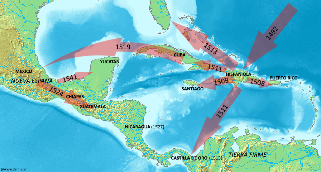 Spanish expansion routes in the Caribbean during the early 16th century Christopher Columbus discovered the New World for the Kingdom of Castile and León in 1492. Private adventurers thereafter entered into contracts with the Spanish Crown to conquer the newly discovered lands in return for tax revenues and the power to rule.[19] In the first decades after the discovery of the new lands, the Spanish colonised the Caribbean and established a centre of operations on the island of Cuba. They heard rumours of the rich empire of the Aztecs on the mainland to the west and, in 1519, Hernán Cortés set sail with eleven ships to explore the Mexican coast.[20] By August 1521 the Aztec capital of Tenochtitlan had fallen to the Spanish and their allies.[21] A single soldier arriving in Mexico in 1520 was carrying smallpox and thus initiated the devastating plagues that swept through the native populations of the Americas.[22] Within three years of the fall of Tenochtitlan the Spanish had conquered a large part of Mexico, extending as far south as the Isthmus of Tehuantepec. The newly conquered territory became New Spain, headed by a viceroy who answered to the king of Spain via the Council of the Indies.[23] Hernán Cortés received reports of rich, populated lands to the south and dispatched Pedro de Alvarado to investigate the region.[1] Preparations In the run-up to the announcement that an invasion force was to be sent to Guatemala, 10,000 Nahua warriors had already been assembled by the Aztec emperor Cuauhtémoc to accompany the Spanish expedition. Warriors were ordered to be gathered from each of the Mexica and Tlaxcaltec towns. The native warriors supplied their weapons, including swords, clubs and bows and arrows.[24] Alvarado's army left Tenochtitlan at the beginning of the dry season, sometime between the second half of November and December 1523. As Alvarado left the Aztec capital, he led about 400 Spanish and approximately 200 Tlaxcalan and Cholulan warriors and 100 Mexica, meeting up with the gathered reinforcements on the way. When the army left the Basin of Mexico, it may have included as many as 20,000 native warriors from various kingdoms, although the exact numbers are disputed.[25] By the time the army crossed the Isthmus of Tehuantepec, the massed native warriors included 800 from Tlaxcala, 400 from Huejotzingo, 1,600 from Tepeaca plus many more from other former Aztec territories. Further Mesoamerican warriors were recruited from the Zapotec and Mixtec provinces, with the addition of more Nahuas from the Aztec garrison in Soconusco.[26] |
背景 16世紀初頭のスペインによるカリブ海地域への進出ルート 1492年、クリストファー・コロンブスがカスティーリャ王国とレオン王国のために新大陸を発見した。その後、私的な冒険家たちがスペイン王室と契約を結 び、税収と統治権と引き換えに新大陸の征服に乗り出した[19]。新大陸発見から最初の数十年、スペインはカリブ海を植民地化し、キューバ島に活動の拠点 を作った。彼らは西の大陸にあるアステカ帝国の富の噂を耳にし、1519年、エルナン・コルテスが11隻の船でメキシコ沿岸を探検に出航した[20]。 1521年8月までに、アステカの首都テノチティトランはスペインとその同盟軍に降伏した[21]。1520年にメキシコに到着した一人の兵士が天然痘を 運んでいたため、アメリカ大陸の先住民を襲った壊滅的な疫病の始まりとなった[22]。テノチティトラン陥落から3年以内に、スペインはメキシコの大半を 征服し、テワンテペック地峡の南まで勢力を拡大した。新たに征服された領土は、スペイン国王に直属する総督が統治する「新スペイン」となった。総督は、イ ンド評議会を通じてスペイン国王に報告する義務を負っていた[23]。エルナン・コルテスは、南部に豊かな人口の多い土地があるという報告を受け、その地 域を調査するためにペドロ・デ・アルバラードを派遣した[1]。 準備 グアテマラへの侵攻部隊の派遣が発表されるまでに、スペイン遠征に同行するナワ族の戦士1万人がアステカの皇帝クアウテモックによってすでに集結してい た。戦士たちは、メシカ族とトラスカルテク族のそれぞれの町から集められ、 先住民戦士たちは、剣、棍棒、弓矢などの武器を用意した[24]。アルヴァラドの軍隊は、11月後半から12月15日までの乾季の始まりにテノチティトラ ンを出発した。アルヴァラドがアステカの首都を去るとき、彼はスペイン人約400人、トラスカラン人とチョルラン人の戦士約200人、そしてメシカ人 100人を率いており、途中で集まった援軍と合流した。軍がメキシコ盆地を出発した際、正確な人数は議論の余地があるものの、さまざまな王国から集まった 2万人もの先住民戦士が参加していた可能性がある[25]。軍がテワンテペック地峡を渡る頃には、集結した先住民戦士にはトラスカラから800人、ウエホ ツィンゴから400人、テペアカから1,600人、さらにその他多くのアステカの旧領土からの戦士が含まれていた。さらに、サポテカ族とミシュテカ族の地 域からメソアメリカの戦士たちが徴用され、ソコヌスコのアステカの守備隊からさらに多くのナワ族が加わった[26]。 |
Guatemala before the conquest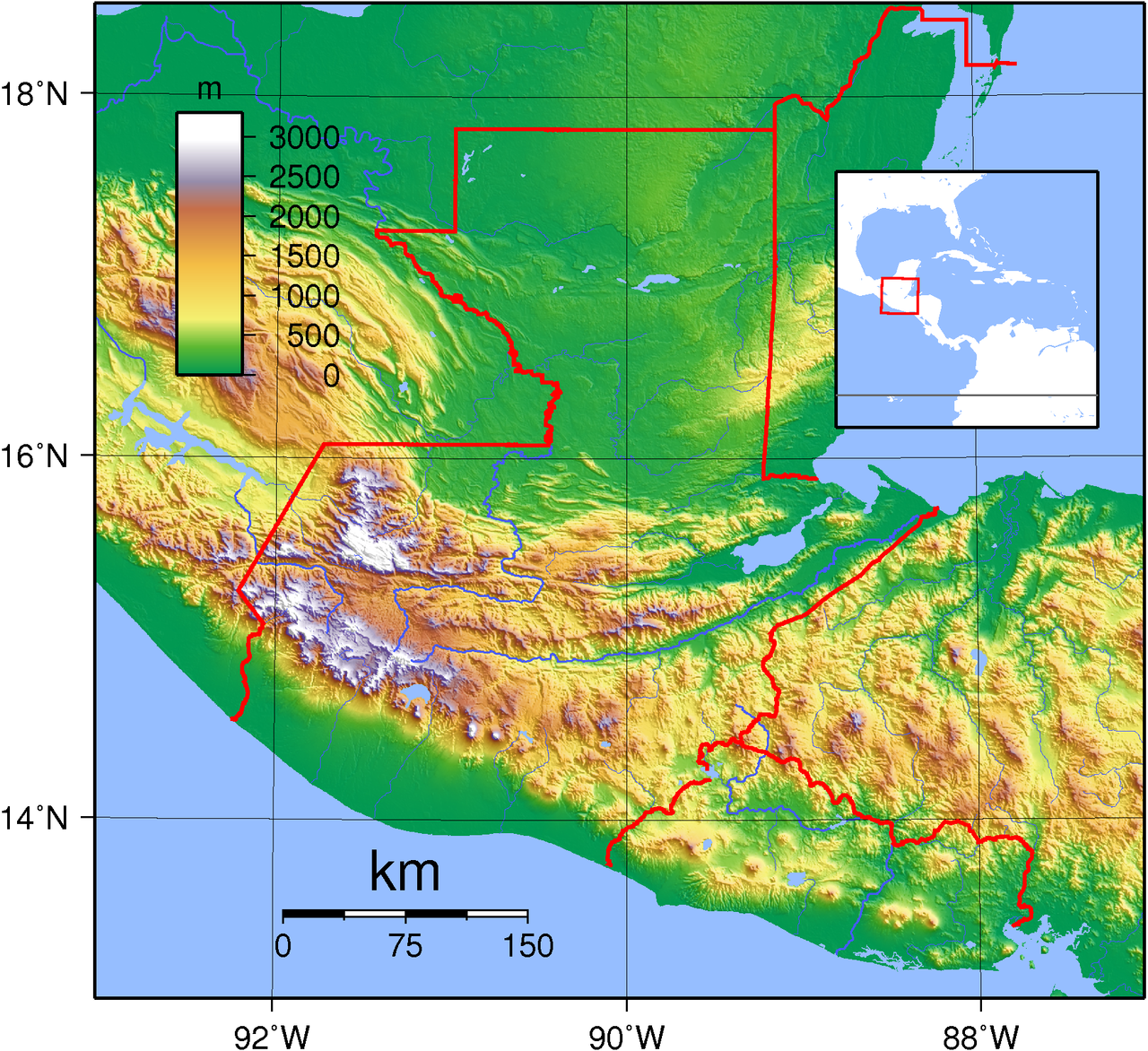 Guatemala is situated between the Pacific Ocean to the south and the Caribbean Sea to the northeast. The broad band of the Sierra Madre mountains sweeps down from Mexico in the west, across southern and central Guatemala and into El Salvador and Honduras to the east. The north is dominated by a broad lowland plain that extends eastwards into Belize and north into Mexico. A narrower plain separates the Sierra Madre from the Pacific Ocean to the south. Relief map of Guatemala showing the three broad geographical areas: the southern Pacific lowlands, the highlands and the northern Petén lowlands In the early 16th century the territory that now makes up Guatemala was divided into various competing polities, each locked in continual struggle with its neighbours.[27] The most important were the Kʼicheʼ, the Kaqchikel, the Tzʼutujil, the Chajoma,[28] the Mam, the Poqomam and the Pipil.[29] All were Maya groups except for the Pipil, who were a Nahua group related to the Aztecs; the Pipil had a number of small city-states along the Pacific coastal plain of southern Guatemala and El Salvador.[30] The Pipil of Guatemala had their capital at Itzcuintepec.[31] The Xinca were another non-Maya group occupying the southeastern Pacific coastal area.[32] The Maya had never been unified as a single empire, but by the time the Spanish arrived Maya civilization was thousands of years old and had already seen the rise and fall of great cities.[33] On the eve of the conquest the highlands of Guatemala were dominated by several powerful Maya states.[34] In the centuries preceding the arrival of the Spanish the Kʼicheʼ had carved out a small empire covering a large part of the western Guatemalan Highlands and the neighbouring Pacific coastal plain. However, in the late 15th century the Kaqchikel rebelled against their former Kʼicheʼ allies and founded a new kingdom to the southeast with Iximche as its capital. In the decades before the Spanish invasion the Kaqchikel kingdom had been steadily eroding the kingdom of the Kʼicheʼ.[35] Other highland groups included the Tzʼutujil around Lake Atitlán, the Mam in the western highlands and the Poqomam in the eastern highlands.[29] The kingdom of the Itza was the most powerful polity in the Petén lowlands of northern Guatemala,[36] centred on their capital Nojpetén, on an island in Lake Petén Itzá.[nb 1] The second polity in importance was that of their hostile neighbours, the Kowoj. The Kowoj were located to the east of the Itza, around the eastern lakes: Lake Salpetén, Lake Macanché, Lake Yaxhá and Lake Sacnab.[37] Other groups are less well known and their precise territorial extent and political makeup remains obscure; among them were the Chinamita, the Kejache, the Icaiche, the Lakandon Chʼol, the Mopan, the Manche Chʼol and the Yalain.[38] The Kejache occupied an area north of the lake on the route to Campeche, while the Mopan and the Chinamita had their polities in the southeastern Petén.[39] The Manche territory was to the southwest of the Mopan.[40] The Yalain had their territory immediately to the east of Lake Petén Itzá.[41] Native weapons and tactics Maya warfare was not so much aimed at destruction of the enemy as the seizure of captives and plunder.[42] The Spanish described the weapons of war of the Petén Maya as bows and arrows, fire-sharpened poles, flint-headed spears and two-handed swords crafted from strong wood with the blade fashioned from inset obsidian,[43] similar to the Aztec macuahuitl. Pedro de Alvarado described how the Xinca of the Pacific coast attacked the Spanish with spears, stakes and poisoned arrows.[44] Maya warriors wore body armour in the form of quilted cotton that had been soaked in salt water to toughen it; the resulting armour compared favourably to the steel armour worn by the Spanish. The Maya had historically employed ambush and raiding as their preferred tactic, and its employment against the Spanish proved troublesome for the Europeans.[45] In response to the use of cavalry, the highland Maya took to digging pits on the roads, lining them with fire-hardened stakes and camouflaging them with grass and weeds, a tactic that according to the Kaqchikel killed many horses.[46] |
征服前のグアテマラ グアテマラは、南に太平洋、北東にカリブ海を望む位置にあります。西のメキシコからグアテマラ南部と中部を横断し、東のエルサルバドルとホンジュラスに広 がるシエラマドレ山脈の広大な山脈帯。北部は広大な低地平原が広がり、東はベリーズ、北はメキシコへと続いている。太平洋に面したシエラマドレ山脈と太平 洋の間には、より狭い平原が広がっている。 グアテマラの地形図。南部の太平洋低地、高地、北部のペテン低地の3つの広大な地域を示している 16世紀初頭、現在のグアテマラ領土は、互いに争いを繰り広げるさまざまな政治勢力によって分割されていた[27]。最も重要な勢力は、キチェ、カクチケ ル、ツツジル、チャヨマ[28]、マム、ポ [29] ピピルを除くすべてのグループはマヤ系民族であった。ピピルはアステカ族と関係のあるナワ族であり、グアテマラとエルサルバドルの太平洋沿岸平野に多数の 小都市国家を擁していた[30]。グアテマラのピピルはイツクインテペックを首都としていた[31]。また、シンカ族も太平洋沿岸南東部を占領していたマ ヤ系以外の民族であった[32]。マヤは決して単一帝国として統一されたことはなかったが、スペイン人が到着した時点でマヤ文明は数千年の歴史を持ち、す でに偉大な都市の興亡を経験していた[33]。 征服前夜、グアテマラの高地はいくつかの強力なマヤ国家によって支配されていた[34]。スペイン人が到着する数世紀前から、キチェ族はグアテマラ高原の 西部および隣接する太平洋沿岸平野の大部分をカバーする小さな帝国を築いていた。しかし、15世紀後半にカクチケル族がかつての同盟国キチェ族に反抗し、 イシムチェを首都とする新たな王国を南東部に建国した。スペインの侵略前の数十年、カクチケル王国はキチェ王国を徐々に侵食していた[35]。その他の高 地民族には、アティトラン湖周辺のツトゥヒル族、西高地に住むマム族、東高地に住むポコマン族などがいた[29]。 イツァ王国は、グアテマラ北部のペテン低地において最も強力な政治体であった[36]。ペテン・イツァ湖の島にある首都ノペテンを中心に栄えた[注釈 1]。次に重要な政治体は、敵対関係にあったコウォイ族の政治体であった。コウォイ族は、イッツァ族の東、東部の湖の周辺に居住していた。サルペテン湖、 マカンチェ湖、ヤシュハ湖、サクナブ湖である[37]。その他の集団はあまり知られておらず、正確な領土の範囲や政治体制は不明瞭である。その中には、シ ナミタ、ケジャチェ、イカチェ、ラカンドン・チョル、モパン、マンチェ・チョル、ヤラインなどが含まれる[38]。ケジャチェ族は湖の北、カンペチェへの 道沿いに居住し、モパン族とシナミタ族はペテンの南東部に政治体制を築いていた[39]。マンチェ族の領土はモパン族の南西に位置していた[40]。ヤラ イン族はペテン・イッツァ湖のすぐ東に領土を持っていた[41]。 先住民の武器と戦術 マヤの戦争は マヤの戦争は、敵の破壊よりも捕虜の捕獲と略奪を目的としていた[42]。スペイン人はペテン・マヤの戦争の武器を、弓矢、火で尖らせた棒、火打ち石を頭 につけた槍、そして強固な木材から作られた両手剣(刃の部分は黒曜石をはめ込んで作られていた)[43]、アステカのマカウィトルに似たものと説明してい る。ペドロ・デ・アルバラードは、太平洋沿岸のシンカ族が槍、杭、毒矢でスペイン軍を攻撃した様子を記している[44]。マヤの戦士たちは、塩水に浸して 堅くした綿のキルティングでできた胴衣を着ていた。出来上がった鎧は、スペイン軍が着用していた鋼鉄製の鎧よりも優れていた。マヤ人は歴史的に待ち伏せや 奇襲を好んで用いており、スペイン人に対してその戦術を用いることはヨーロッパ人にとって厄介なものであった[45]。騎兵隊の使用に対抗して、高地に住 むマヤ人は道路に穴を掘り、火で焼いた杭を並べ、草や雑草でそれをカムフラージュするという戦術を用いた。カクチケル族によると、この戦術によって多くの 馬が殺されたという[46]。 |
|
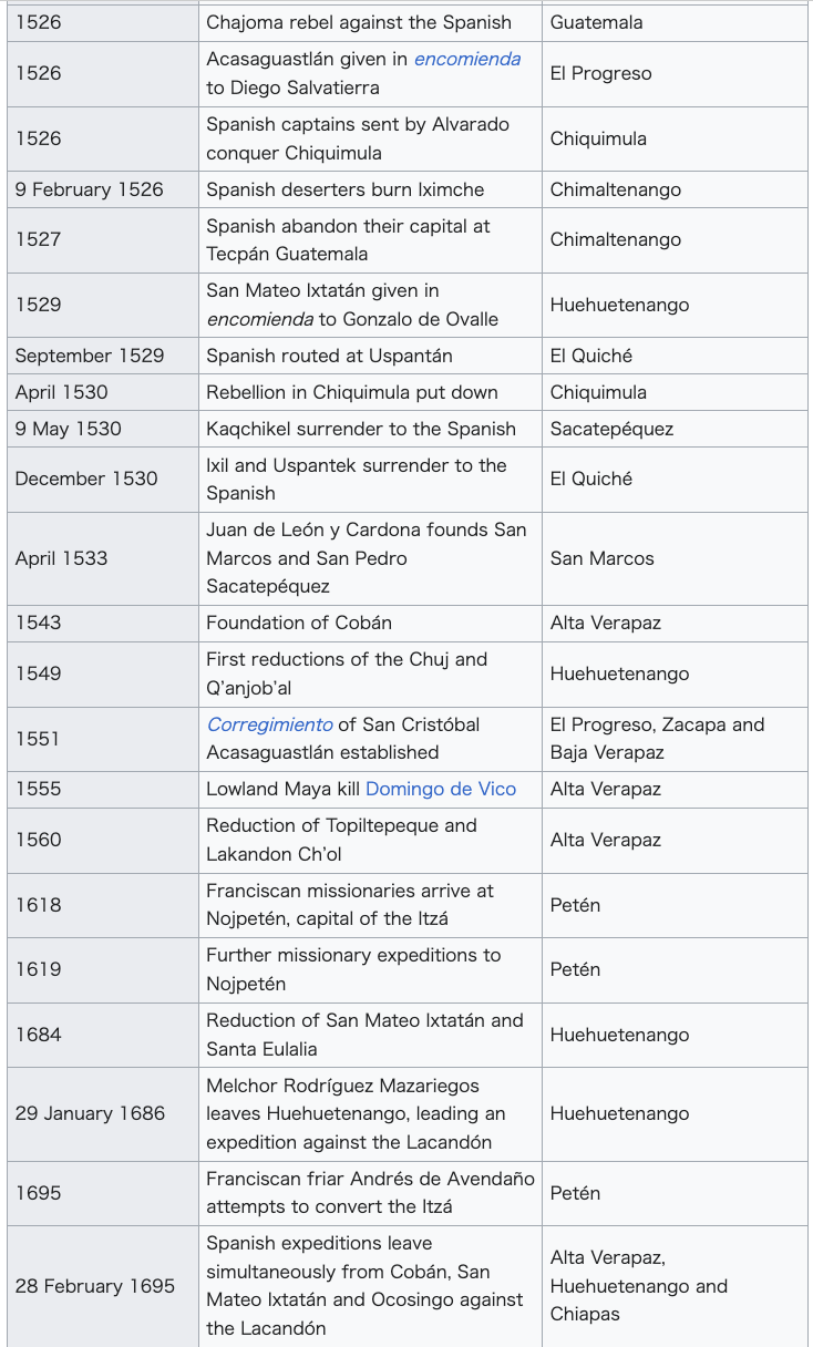
Conquistadors We came here to serve God and the King, and also to get rich.[nb 2]----Bernal Díaz del Castillo[47] Pedro de Alvarado entered Guatemala from the west along the southern Pacific plain in 1524, before swinging northwards and fighting a number of battles to enter the highlands. He then executed a broad loop around the north side of the highland Lake Atitlán, fighting further battles along the way, before descending southwards once more into the Pacific lowlands. Two more battles were fought as his forces headed east into what is now El Salvador. In 1525 Hernán Cortés entered northern Guatemala from the north, crossed to Lake Petén Itzá and continued roughly southeast to Lake Izabal before turning east to the Gulf of Honduras. 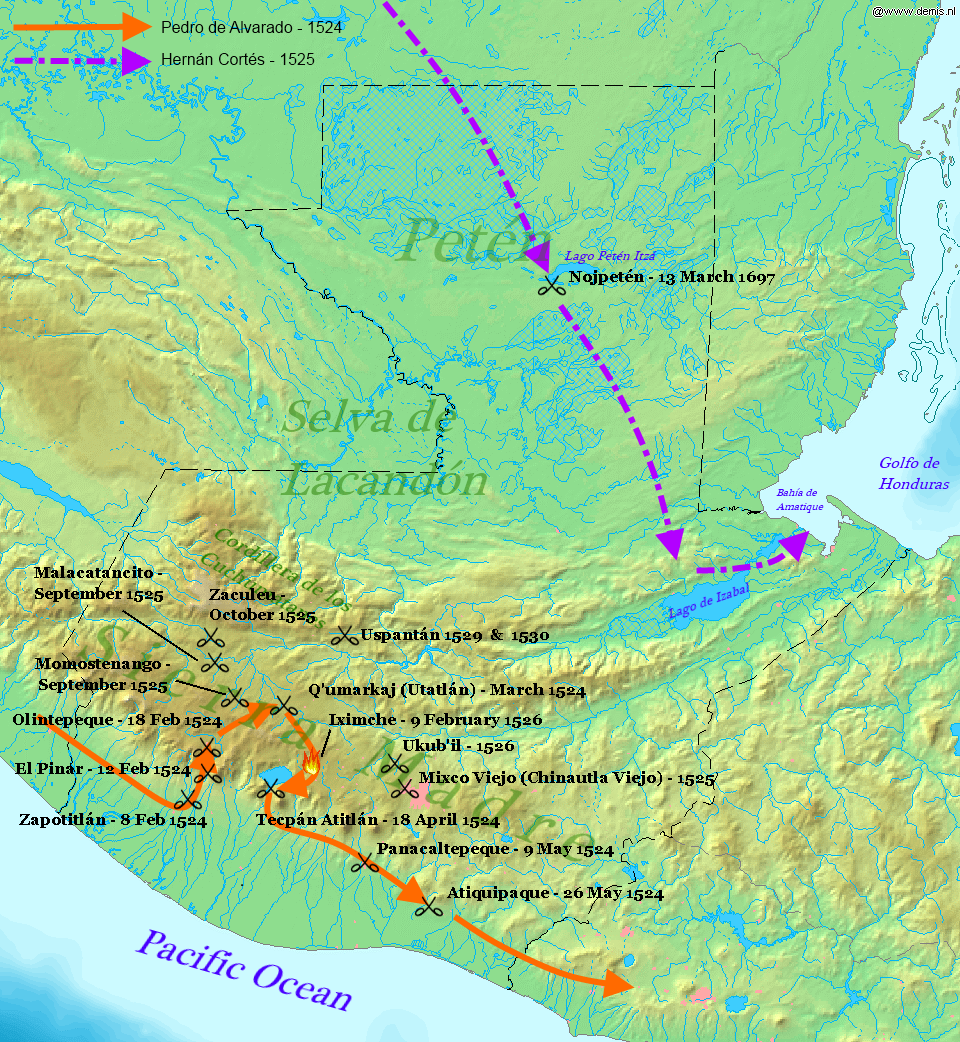 Map of the principal entry routes and battle sites of the conquest of Guatemala The conquistadors were all volunteers, the majority of whom did not receive a fixed salary but instead a portion of the spoils of victory, in the form of precious metals, land grants and provision of native labour.[48] Many of the Spanish were already experienced soldiers who had previously campaigned in Europe.[49] The initial incursion into Guatemala was led by Pedro de Alvarado, who earned the military title of Adelantado in 1527;[50] he answered to the Spanish crown via Hernán Cortés in Mexico.[49] Other early conquistadors included Pedro de Alvarado's brothers Gómez de Alvarado, Jorge de Alvarado and Gonzalo de Alvarado y Contreras; and his cousins Gonzalo de Alvarado y Chávez, Hernando de Alvarado and Diego de Alvarado.[7] Pedro de Portocarrero was a nobleman who joined the initial invasion.[51] Bernal Díaz del Castillo was a petty nobleman who accompanied Hernán Cortés when he crossed the northern lowlands, and Pedro de Alvarado on his invasion of the highlands.[52] In addition to Spaniards, the invasion force probably included dozens of armed African slaves and freedmen.[53] |
征服者 私たちは神と王に仕えるため、そして富を得るためにここに来た。——ベルナル・ディアス・デル・カスティージョ[47] 1524年、ペドロ・デ・アルバラードはグアテマラに西から入り、太平洋の南側の平野に沿って北上し、高地に入るために多くの戦いを繰り広げた。その後、 彼は高地にあるアティトラン湖の北側をぐるりと回り、さらにその道中で戦闘を繰り広げ、再び南に下りて太平洋の低地へと向かった。エルサルバドルへと向か う彼の部隊は、さらに2回の戦闘を繰り広げた。1525年、エルナン・コルテスがグアテマラ北部からペテン・イッツァ湖を渡り、ほぼ南東のイサバル湖へと 進み、そこから東に曲がってホンジュラス湾へと向かった。 グアテマラ征服の主な進入ルートと戦闘地の地図 征服者たちは皆志願兵であり、その大半は固定給ではなく、戦利品の一部として、貴金属、土地の贈与、先住民の労働力の提供を受けていた[48]。スペイン 人の多くは、ヨーロッパで既に戦役を経験していたベテラン兵士であった[49]。グアテマラへの最初の侵入は、ペドロ・デ・アルバラドが指揮し、1527 年に軍事的称号である 1527年に「先駆者」の称号を得た[50]。彼はメキシコにいるエルナン・コルテスを通じてスペイン王に報告していた[49]。初期の征服者としては、 ペドロ・デ・アルバラドの兄弟であるゴメス・デ・アルバラド、ホルヘ・デ・アルバラド、ゴンサロ・デ・アルバラド・イ・コントレラス、そして従兄弟のゴン サロ・デ・アルバラド・イ・チャベス、エルナン・デ・アルバラド、ディエゴ・デ・アルバラドなどがいた[7]。ペドロ・デ・ポルトカロー ペドロ・デ・ポルトカローは、最初の侵略に参加した貴族であった[51]。ベルナル・ディアス・デル・カスティージョは、エルナン・コルテスが北部低地を 通過する際に同行した小貴族であり、ペドロ・デ・アルバラドが高地への侵略に同行した[52]。スペイン人以外にも、おそらく武装した数十人のアフリカ人 奴隷や解放奴隷が侵略軍に加わっていた[53]。 |
|
Spanish weapons and tactics Spanish weaponry and tactics differed greatly from that of the indigenous peoples of Guatemala. This included the Spanish use of crossbows, firearms (including muskets and cannon),[54] war dogs and war horses.[55] Among Mesoamerican peoples the capture of prisoners was a priority, while to the Spanish such taking of prisoners was a hindrance to outright victory.[55] The inhabitants of Guatemala, for all their sophistication, lacked key elements of Old World technology, such as the use of iron and steel and functional wheels.[56] The use of steel swords was perhaps the greatest technological advantage held by the Spanish, although the deployment of cavalry helped them to rout indigenous armies on occasion.[57] The Spanish were sufficiently impressed by the quilted cotton armour of their Maya enemies that they adopted it in preference to their own steel armour.[45] The conquistadors applied a more effective military organisation and strategic awareness than their opponents, allowing them to deploy troops and supplies in a way that increased the Spanish advantage.[58]  Representation of a battle between a native and a conquistador. In Guatemala the Spanish routinely fielded indigenous allies; at first these were Nahuas brought from the recently conquered Mexico, later they also included Mayas. It is estimated that for every Spaniard on the field of battle, there were at least 10 native auxiliaries. Sometimes there were as many as 30 indigenous warriors for every Spaniard, and it was the participation of these Mesoamerican allies that was particularly decisive.[59] In at least one case, encomienda rights were granted to one of the Tlaxcalan leaders who came as allies, and land grants and exemption from being given in encomienda were given to the Mexican allies as rewards for their participation in the conquest.[60] In practice, such privileges were easily removed or sidestepped by the Spanish and the indigenous conquistadors were treated in a similar manner to the conquered natives.[61] The Spanish engaged in a strategy of concentrating native populations in newly founded colonial towns, or reducciones (also known as congregaciones). Native resistance to the new nucleated settlements took the form of the flight of the indigenous inhabitants into inaccessible regions such as mountains and forests.[62] |
スペインの武器と戦術 スペインの武器と戦術は、グアテマラの先住民のものとは大きく異なっていた。これには、スペイン人がクロスボウ、火器(マスケット銃や大砲を含む)、 [54] 戦犬、軍馬を使用していたことが含まれる[55]。メソアメリカの人々にとって捕虜の捕獲は優先事項であったが、スペイン人にとっては捕虜の捕獲は完全な 勝利の妨げであった[55]。グアテマラの住民は、 グアテマラの住民は、その洗練された文化にもかかわらず、鉄や鋼鉄の使用や車輪などの旧世界の技術的要素を欠いていた[56]。鋼鉄製の剣の使用は、スペ イン人が持つ最大の技術的優位性であったかもしれないが、騎兵隊の投入は、時に先住民軍を撃破するのに役立った[57]。スペイン人は、マヤの敵の綿入れ の綿入れの鎧に十分に感銘を受け、 マヤの敵のキルティング加工を施した綿の鎧に感銘を受けたスペイン人は、自分たちの鋼鉄製の鎧よりもそれを好んで採用した[45]。征服者たちは、敵より も効果的な軍事組織と戦略的認識を適用し、スペインの優位性を高めるような方法で軍隊と物資を展開することができた[58]。 先住民と征服者との戦いの描写。 グアテマラでは、スペイン人は日常的に先住民を味方につけていた。最初は、最近征服したメキシコから連れてきたナワ族だったが、後にはマヤ族も含まれるよ うになった。戦場にいたスペイン人の1人につき、少なくとも10人の先住民が味方についていたと推定されている。時にはスペイン人1人に対して先住民戦士 が30人いたこともあり、特に決定的だったのはこれらのメソアメリカ同盟者の参加であった[59]。少なくとも1つのケースでは、同盟者として参加したト ラスカランの指導者の1人にエンコミエンダ権が与えられ、メキシコ人同盟者には征服への参加に対する報酬として土地の贈与とエンコミエンダからの免除が与 えられた 征服に参加した報酬として、メキシコ人同盟軍にも土地の贈与とエンコミエンダからの免除が与えられた[60]。実際には、このような特権はスペイン人に よって簡単に剥奪されたり回避されたりした。先住民征服者は征服された先住民と同様の扱いを受けた[61]。 スペイン人は、新たに設立された植民地都市、またはレドゥクション(congregacionesとも呼ばれる)に先住民を集中させる戦略を採用した。新しい中心都市への先住民の抵抗は、先住民が山や森林などの人里離れた地域へ逃亡するという形をとった[62]。 |
| Impact of Old World diseases Epidemics accidentally introduced by the Spanish included smallpox, measles and influenza. These diseases, together with typhus and yellow fever, had a major impact on Maya populations.[63] The Old World diseases brought with the Spanish and against which the indigenous New World peoples had no resistance were a deciding factor in the conquest; the diseases crippled armies and decimated populations before battles were even fought.[64] Their introduction was catastrophic in the Americas; it is estimated that 90% of the indigenous population had been eliminated by disease within the first century of European contact.[65] In 1519 and 1520, before the arrival of the Spanish in the region, a number of epidemics swept through southern Guatemala.[66] At the same time as the Spanish were occupied with the overthrow of the Aztec Empire, a devastating plague struck the Kaqchikel capital of Iximche, and the city of Qʼumarkaj, capital of the Kʼicheʼ, may also have suffered from the same epidemic.[67] It is likely that the same combination of smallpox and a pulmonary plague swept across the entire Guatemalan Highlands.[68] Modern knowledge of the impact of these diseases on populations with no prior exposure suggests that 33–50% of the population of the highlands perished. Population levels in the Guatemalan Highlands did not recover to their pre-conquest levels until the middle of the 20th century.[69] In 1666 pestilence or murine typhus swept through what is now the department of Huehuetenango. Smallpox was reported in San Pedro Saloma, in 1795.[70] At the time of the fall of Nojpetén in 1697, there are estimated to have been 60,000 Mayas living around Lake Petén Itzá, including a large number of refugees from other areas. It is estimated that 88% of them died during the first ten years of colonial rule owing to a combination of disease and war.[71] |
旧世界病の影響 スペイン人が偶然持ち込んだ疫病には、天然痘、はしか、インフルエンザなどが含まれる。これらの病気は、チフスや黄熱病とともにマヤの人口に多大な影響を 与えた[63]。スペイン人がもたらし、先住民の新世界の人々が抵抗手段を持たない旧世界の病気は、征服の決定的な要因となった。これらの病気は、戦闘が 始まる前に軍隊を無力化し、人口を激減させた[64]。これらの病気の伝播はアメリカ大陸にとって壊滅的なものであり、ヨーロッパ人との接触から最初の1 世紀以内に先住民の人口の90%が ヨーロッパ人との接触から最初の1世紀の間に、先住民の人口の90%が病によって失われたと推定されている[65]。 1519年と1520年、スペイン人がこの地域に到着する前に、グアテマラ南部を多数の疫病が襲った[66]。スペイン人がアステカ帝国の打倒に忙殺され ているのと同時に、カクチケル族の首都イシムチェを壊滅的なペストが襲い、 キチェ族の首都であるクマルカフ市も、同じ疫病に苦しんだ可能性がある[67]。天然痘と肺ペストのコンビネーションが、グアテマラ高原全域を襲った可能 性が高い[68]。これらの病気が、それまで感染経験のない人口に与えた影響に関する最新の知識によると、高原の人口の33~50%が死亡したと考えられ る。グアテマラ高原の人口は、20世紀半ばになるまで征服前の水準まで回復しなかった[69]。1666年には、現在のウエウエテナンゴ県をペストやネズ ミチフスが襲った。天然痘は1795年にサン・ペドロ・サロマで報告されている[70]。1697年のノペテンの陥落当時、ペテン・イッツァ湖周辺には、 他の地域からの多数の避難民を含め、6万人のマヤ人が住んでいたと推定されている。植民地支配の最初の10年間で、病気と戦争により、彼らの88%が死亡 したと推定されている[71]。 |
| コロンブスの交換 |
コロンブス交換(コ
ロンブスこうかん、英: Columbian
exchange)とは、15世紀後半以降、西半球の新世界(アメリカ大陸)と東半球の旧世界(アフロ・ユーラシア大陸)の間で、植物、動物、貴金属、商
品、文化、人口、技術、病気、思想などが広範囲に渡って交換されたことである。
[イタリアの探検家クリストファー・コロンブスにちなんで命名され、彼の1492年の航海後のヨーロッパの植民地化と世界貿易に関連している。旧世界に由
来する伝染病は、15世紀以降、アメリカ大陸の先住民の数を80~95%減少させる結果となり、カリブ海地域では最も深刻だった。ヨーロッパ人入植者とア
フリカ人奴隷は、程度の差こそあれ、アメリカ大陸の先住民に取って代わった。新大陸に連れて行かれたアフリカ人の数は、コロンブス後の最初の3世紀に新大
陸に移動したヨーロッパ人の数をはるかに上回っていた。
世界人口の新たな接触は、多種多様な作物や家畜の交流をもたらし、旧世界における食糧生産と人口の増加を支えた。トウモロコシ、ジャガイモ、トマト、タバ
コ、キャッサバ、サツマイモ、唐辛子といったアメリカの作物は、世界中で重要な作物となった。旧世界の米、小麦、サトウキビ、家畜などの作物は、新世界で
も重要な作物となった。アメリカで生産された銀は世界中に溢れ、特に帝国中国で硬貨に使われる標準的な金属となった。
この言葉は、1972年にアメリカの歴史家であり教授でもあるアルフレッド・W・クロスビーが環境史の著書『コロンブス交換』の中で初めて使用した。 |
 |
|
 |
|
 |
|
| Conquest of the highlands The highlands of Guatemala are bordered by the Pacific plain to the south, with the coast running to the southwest. The Kaqchikel kingdom was centred on Iximche, located roughly halfway between Lake Atitlán to the west and modern Guatemala City to the east. The Tzʼutujil kingdom was based around the south shore of the lake, extending into the Pacific lowlands. The Pipil were situated further east along the Pacific plain and the Pocomam occupied the highlands to the east of modern Guatemala City. The Kʼicheʼ kingdom extended to the north and west of the lake with principal settlements at Xelaju, Totonicapan, Qʼumarkaj, Pismachiʼ and Jakawitz. The Mam kingdom covered the western highlands bordering modern Mexico. 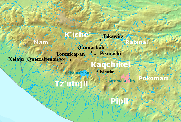 Map of the Guatemalan Highlands on the eve of the Spanish conquest The conquest of the highlands was made difficult by the many independent polities in the region, rather than one powerful enemy to be defeated as was the case in central Mexico.[73] After the Aztec capital Tenochtitlan fell to the Spanish in 1521, the Kaqchikel Maya of Iximche sent envoys to Hernán Cortés to declare their allegiance to the new ruler of Mexico, and the Kʼicheʼ Maya of Qʼumarkaj may also have sent a delegation.[74] In 1522 Cortés sent Mexican allies to scout the Soconusco region of lowland Chiapas, where they met new delegations from Iximche and Qʼumarkaj at Tuxpán;[75] both of the powerful highland Maya kingdoms declared their loyalty to the king of Spain.[74] But Cortés' allies in Soconusco soon informed him that the Kʼicheʼ and the Kaqchikel were not loyal, and were instead harassing Spain's allies in the region. Cortés decided to despatch Pedro de Alvarado with 180 cavalry, 300 infantry, crossbows, muskets, 4 cannons, large amounts of ammunition and gunpowder, and thousands of allied Mexican warriors from Tlaxcala, Cholula and other cities in central Mexico;[76] they arrived in Soconusco in 1523.[74] Pedro de Alvarado was infamous for the massacre of Aztec nobles in Tenochtitlan and, according to Bartolomé de las Casas, he committed further atrocities in the conquest of the Maya kingdoms in Guatemala.[77] Some groups remained loyal to the Spanish once they had submitted to the conquest, such as the Tzʼutujil and the Kʼicheʼ of Quetzaltenango, and provided them with warriors to assist further conquest. Other groups soon rebelled however, and by 1526 numerous rebellions had engulfed the highlands.[78] Subjugation of the Kʼicheʼ 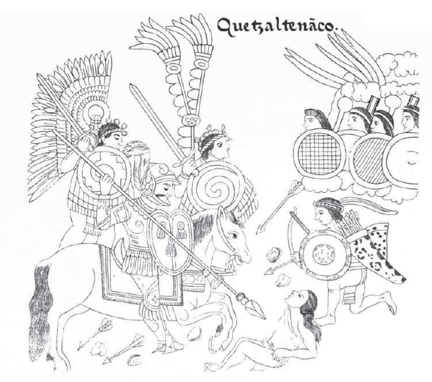 Page from the Lienzo de Tlaxcala showing the conquest of Quetzaltenango 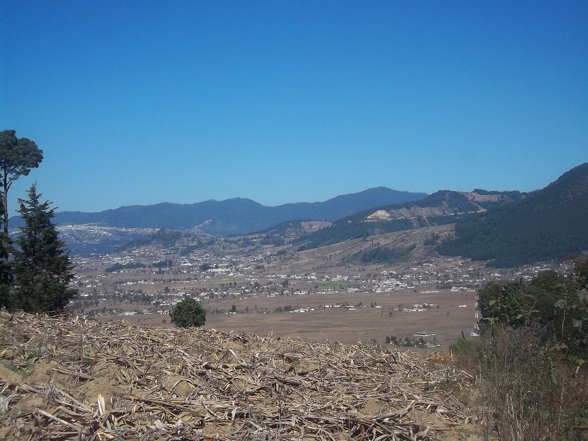 The Plains of Urbina, scene of a decisive battle against the Kʼicheʼ ... we waited until they came close enough to shoot their arrows, and then we smashed into them; as they had never seen horses, they grew very fearful, and we made a good advance ... and many of them died. Pedro de Alvarado describing the approach to Quetzaltenango in his 3rd letter to Hernán Cortés[79] Pedro de Alvarado and his army advanced along the Pacific coast unopposed until they reached the Samalá River in western Guatemala. This region formed a part of the Kʼicheʼ kingdom, and a Kʼicheʼ army tried unsuccessfully to prevent the Spanish from crossing the river. Once across, the conquistadors ransacked nearby settlements in an effort to terrorise the Kʼicheʼ.[5] On 8 February 1524 Alvarado's army fought a battle at Xetulul, called Zapotitlán by his Mexican allies (modern San Francisco Zapotitlán). Although suffering many injuries inflicted by defending Kʼicheʼ archers, the Spanish and their allies stormed the town and set up camp in the marketplace.[80] Alvarado then turned to head upriver into the Sierra Madre mountains towards the Kʼicheʼ heartlands, crossing the pass into the fertile valley of Quetzaltenango. On 12 February 1524 Alvarado's Mexican allies were ambushed in the pass and driven back by Kʼicheʼ warriors but the Spanish cavalry charge that followed was a shock for the Kʼicheʼ, who had never before seen horses. The cavalry scattered the Kʼicheʼ and the army crossed to the city of Xelaju (modern Quetzaltenango) only to find it deserted.[81] Although the common view is that the Kʼicheʼ prince Tecun Uman died in the later battle near Olintepeque, the Spanish accounts are clear that at least one and possibly two of the lords of Qʼumarkaj died in the fierce battles upon the initial approach to Quetzaltenango.[82] The death of Tecun Uman is said to have taken place in the battle of El Pinar,[83] and local tradition has his death taking place on the Llanos de Urbina (Plains of Urbina), upon the approach to Quetzaltenango near the modern village of Cantel.[84] Pedro de Alvarado, in his third letter to Hernán Cortés, describes the death of one of the four lords of Qʼumarkaj upon the approach to Quetzaltenango. The letter was dated 11 April 1524 and was written during his stay at Qʼumarkaj.[83] Almost a week later, on 18 February 1524,[85] a Kʼicheʼ army confronted the Spanish army in the Quetzaltenango valley and were comprehensively defeated; many Kʼicheʼ nobles were among the dead.[86] Such were the numbers of Kʼicheʼ dead that Olintepeque was given the name Xequiquel, roughly meaning "bathed in blood".[87] In the early 17th century, the grandson of the Kʼicheʼ king informed the alcalde mayor (the highest colonial official at the time) that the Kʼicheʼ army that had marched out of Qʼumarkaj to confront the invaders numbered 30,000 warriors, a claim that is considered credible by modern scholars.[88] This battle exhausted the Kʼicheʼ militarily and they asked for peace and offered tribute, inviting Pedro de Alvarado into their capital Qʼumarkaj, which was known as Tecpan Utatlan to the Nahuatl-speaking allies of the Spanish. Alvarado was deeply suspicious of the Kʼicheʼ intentions but accepted the offer and marched to Qʼumarkaj with his army.[89] The day after the battle of Olintepeque, the Spanish army arrived at Tzakahá, which submitted peacefully. There the Spanish chaplains Juan Godínez and Juan Díaz conducted a Roman Catholic mass under a makeshift roof;[90] this site was chosen to build the first church in Guatemala,[91] which was dedicated to Concepción La Conquistadora. Tzakahá was renamed as San Luis Salcajá.[90] The first Easter mass held in Guatemala was celebrated in the new church, during which high-ranking natives were baptised.[91] 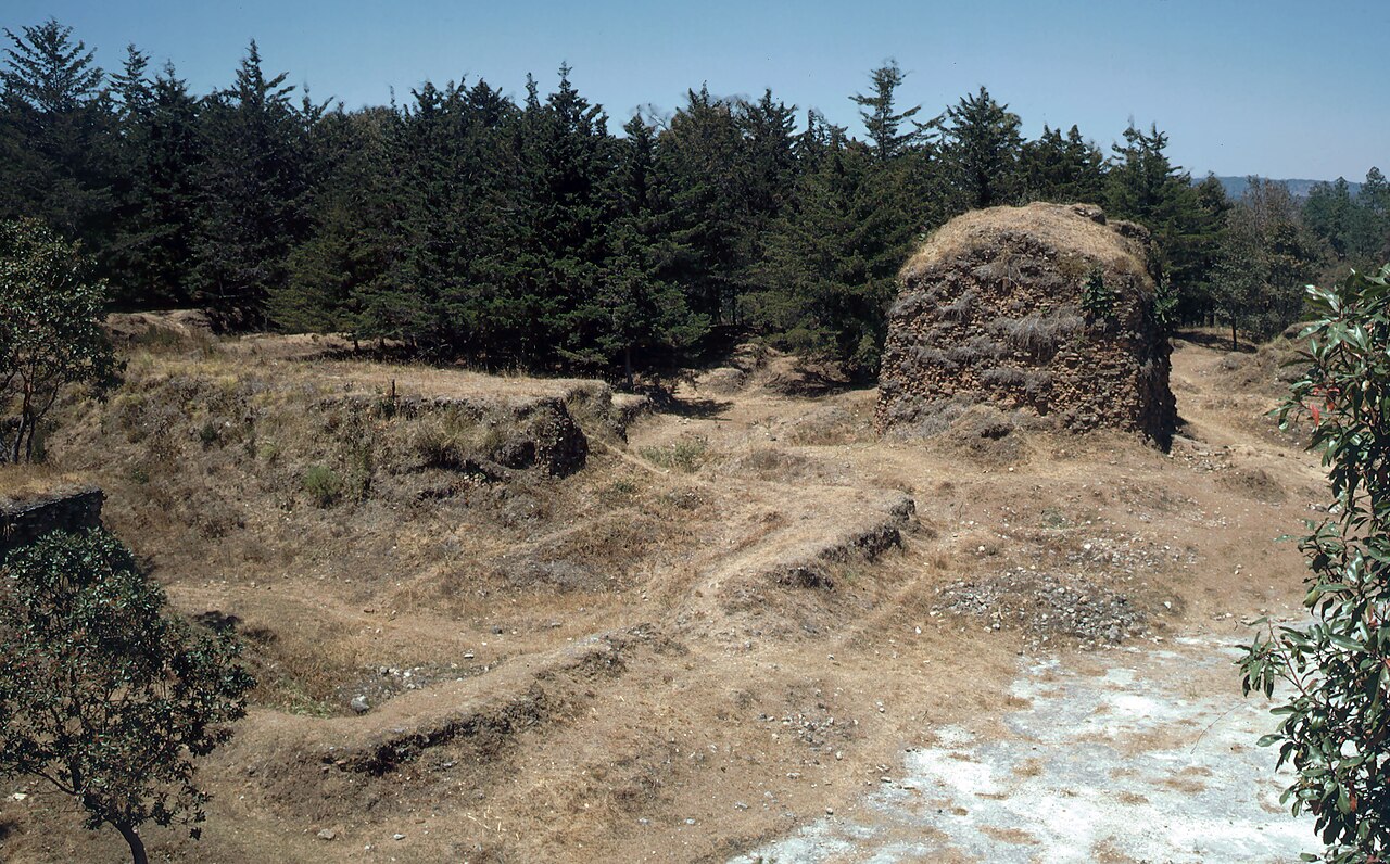 Grass- and scrub-covered ruins set against a backdrop of low pine forest. A crumbling squat square tower stands behind to the right, all that remains of the Temple of Tohil, with the remains of the walls of the ballcourt to the left in the foreground. Qʼumarkaj was the capital of the Kʼicheʼ kingdom until it was burnt by the invading Spanish. In March 1524 Pedro de Alvarado entered Qʼumarkaj at the invitation of the remaining lords of the Kʼicheʼ after their catastrophic defeat,[92] fearing that he was entering a trap.[86] He encamped on the plain outside the city rather than accepting lodgings inside.[93] Fearing the great number of Kʼicheʼ warriors gathered outside the city and that his cavalry would not be able to manoeuvre in the narrow streets of Qʼumarkaj, he invited the leading lords of the city, Oxib-Keh (the ajpop, or king) and Beleheb-Tzy (the ajpop kʼamha, or king elect) to visit him in his camp.[94] As soon as they did so, he seized them and kept them as prisoners in his camp. The Kʼicheʼ warriors, seeing their lords taken prisoner, attacked the Spaniards' indigenous allies and managed to kill one of the Spanish soldiers.[95] At this point Alvarado decided to have the captured Kʼicheʼ lords burnt to death, and then proceeded to burn the entire city.[96] After the destruction of Qʼumarkaj and the execution of its rulers, Pedro de Alvarado sent messages to Iximche, capital of the Kaqchikel, proposing an alliance against the remaining Kʼicheʼ resistance. Alvarado wrote that they sent 4,000 warriors to assist him, although the Kaqchikel recorded that they sent only 400.[89] San Marcos: Province of Tecusitlán and Lacandón With the capitulation of the Kʼicheʼ kingdom, various non-Kʼicheʼ peoples under Kʼicheʼ dominion also submitted to the Spanish. This included the Mam inhabitants of the area now within the modern department of San (. Quetzaltenango and San Marcos were placed under the command of Juan de León y Cardona, who began the reduction of indigenous populations and the foundation of Spanish towns. The towns of San Marcos and San Pedro Sacatepéquez were founded soon after the conquest of western Guatemala.[97] In 1533 Pedro de Alvarado ordered de León y Cardona to explore and conquer the area around the Tacaná, Tajumulco, Lacandón and San Antonio volcanoes; in colonial times this area was referred to as the Province of Tecusitlán and Lacandón.[98] De León marched to a Maya city named Quezalli by his Nahuatl-speaking allies with a force of fifty Spaniards; his Mexican allies also referred to the city by the name Sacatepequez. De León renamed the city as San Pedro Sacatepéquez in honour of his friar, Pedro de Angulo.[98] The Spanish founded a village nearby at Candacuchex in April that year, renaming it as San Marcos.[99] Kaqchikel alliance On 14 April 1524, soon after the defeat of the Kʼicheʼ, the Spanish were invited into Iximche and were well received by the lords Belehe Qat and Cahi Imox.[100][nb 3] The Kaqchikel kings provided native soldiers to assist the conquistadors against continuing Kʼicheʼ resistance and to help with the defeat of the neighbouring Tzʼutuhil kingdom.[101] The Spanish only stayed briefly in Iximche before continuing through Atitlán, Escuintla and Cuscatlán. The Spanish returned to the Kaqchikel capital on 23 July 1524 and on 27 July (1 Qʼat in the Kaqchikel calendar) Pedro de Alvarado declared Iximche as the first capital of Guatemala, Santiago de los Caballeros de Guatemala ("St. James of the Knights of Guatemala").[102] Iximche was called Guatemala by the Spanish, from the Nahuatl Quauhtemallan meaning "forested land". Since the Spanish conquistadors founded their first capital at Iximche, they took the name of the city used by their Nahuatl-speaking Mexican allies and applied it to the new Spanish city and, by extension, to the kingdom. From this comes the modern name of the country.[103] When Pedro de Alvarado moved his army to Iximche, he left the defeated Kʼicheʼ kingdom under the command of Juan de León y Cardona.[104] Although de León y Cardona was given command of the western reaches of the new colony, he continued to take an active role in the continuing conquest, including the later assault on the Poqomam capital.[105] Conquest of the Tzʼutujil 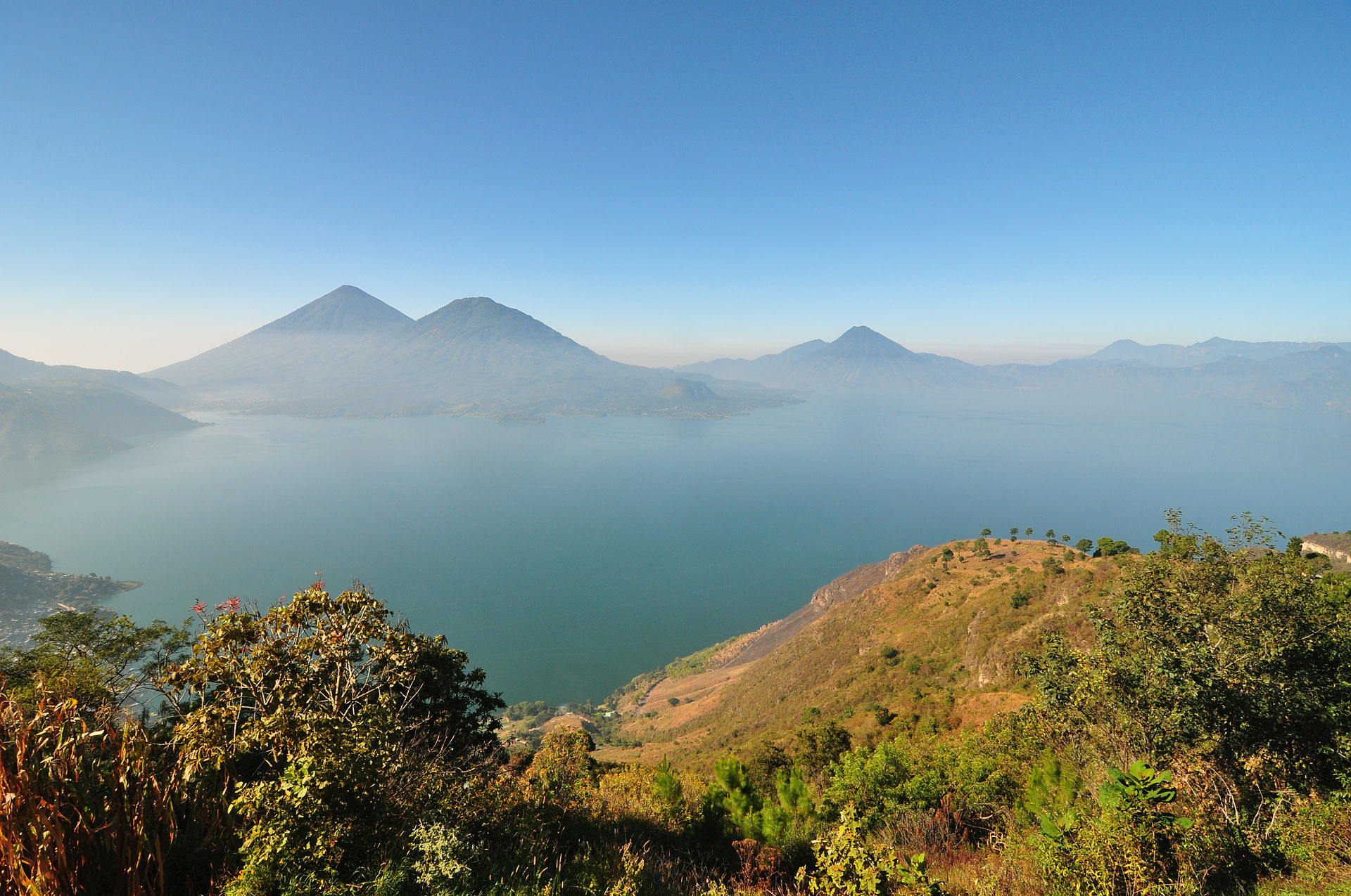 View across hills to a broad lake bathed in a light mist. The mountainous lake shore curves from the left foreground backwards and to the right, with several volcanoes rising from the far shore, framed by a clear blue sky above. The Tzʼutujil kingdom had its capital on the shore of Lake Atitlán. The Kaqchikel appear to have entered into an alliance with the Spanish to defeat their enemies, the Tzʼutujil, whose capital was Tecpan Atitlan.[89] Pedro de Alvarado sent two Kaqchikel messengers to Tecpan Atitlan at the request of the Kaqchikel lords, both of whom were killed by the Tzʼutujil.[106] When news of the killing of the messengers reached the Spanish at Iximche, the conquistadors marched against the Tzʼutujil with their Kaqchikel allies.[89] Pedro de Alvarado left Iximche just 5 days after he had arrived there, with 60 cavalry, 150 Spanish infantry and an unspecified number of Kaqchikel warriors. The Spanish and their allies arrived at the lakeshore after a day's hard march, without encountering any opposition. Seeing the lack of resistance, Alvarado rode ahead with 30 cavalry along the lakeshore. Opposite a populated island the Spanish at last encountered hostile Tzʼutujil warriors and charged among them, scattering and pursuing them to a narrow causeway across which the surviving Tzʼutujil fled.[107] The causeway was too narrow for the horses, therefore the conquistadors dismounted and crossed to the island before the inhabitants could break the bridges.[108] The rest of Alvarado's army soon reinforced his party and they successfully stormed the island. The surviving Tzʼutujil fled into the lake and swam to safety on another island. The Spanish could not pursue the survivors further because 300 canoes sent by the Kaqchikels had not yet arrived. This battle took place on 18 April.[109] The following day the Spanish entered Tecpan Atitlan but found it deserted. Pedro de Alvarado camped in the centre of the city and sent out scouts to find the enemy. They managed to catch some locals and used them to send messages to the Tzʼutujil lords, ordering them to submit to the king of Spain. The Tzʼutujil leaders responded by surrendering to Pedro de Alvarado and swearing loyalty to Spain, at which point Alvarado considered them pacified and returned to Iximche.[109] Three days after Pedro de Alvarado returned to Iximche, the lords of the Tzʼutujil arrived there to pledge their loyalty and offer tribute to the conquistadors.[110] A short time afterwards a number of lords arrived from the Pacific lowlands to swear allegiance to the king of Spain, although Alvarado did not name them in his letters; they confirmed Kaqchikel reports that further out on the Pacific plain was the kingdom called Izcuintepeque in Nahuatl, or Panatacat in Kaqchikel, whose inhabitants were warlike and hostile towards their neighbours.[111] Kaqchikel rebellion 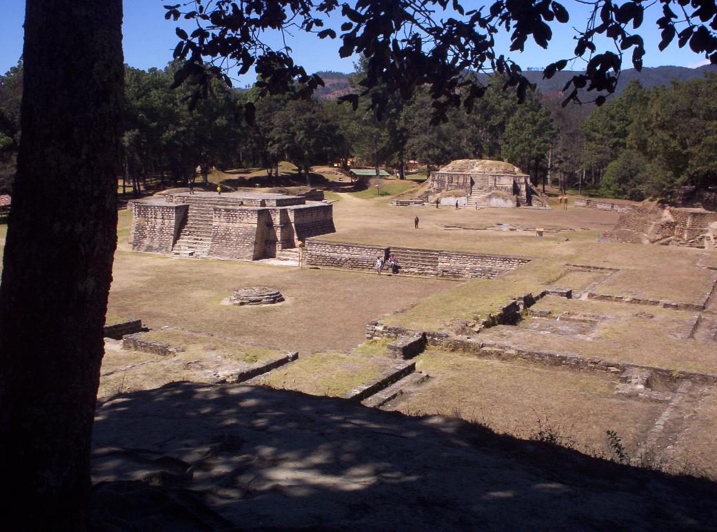 View across a series of neatly maintained low ruins, consisting of a labyrinthine series of overlapping rectangular basal platforms. Two small pyramid structures dominate the view, with pine forest providing the backdrop. The ruins of Iximche, burnt by Spanish deserters Line drawing of a conquistador on horseback charging to the right accompanied by two native warriors on foot in feathered battledress. On the right hand side more simply dressed natives shoot arrows at the attackers. Page from the Lienzo de Tlaxcala depicting the conquest of Iximche Pedro de Alvarado rapidly began to demand gold in tribute from the Kaqchikels, souring the friendship between the two peoples.[112] He demanded that their kings deliver 1000 gold leaves, each worth 15 pesos.[113][nb 4] A Kaqchikel priest foretold that the Kaqchikel gods would destroy the Spanish, causing the Kaqchikel people to abandon their city and flee to the forests and hills on 28 August 1524 (7 Ahmak in the Kaqchikel calendar). Ten days later the Spanish declared war on the Kaqchikel.[112] Two years later, on 9 February 1526, a group of sixteen Spanish deserters burnt the palace of the Ahpo Xahil, sacked the temples and kidnapped a priest, acts that the Kaqchikel blamed on Pedro de Alvarado.[114][nb 5] Conquistador Bernal Díaz del Castillo recounted how in 1526 he returned to Iximche and spent the night in the "old city of Guatemala" together with Luis Marín and other members of Hernán Cortés's expedition to Honduras. He reported that the houses of the city were still in excellent condition; his account was the last description of the city while it was still inhabitable.[115] The Kaqchikel began to fight the Spanish. They opened shafts and pits for the horses and put sharp stakes in them to kill them ... Many Spanish and their horses died in the horse traps. Many Kʼicheʼ and Tzʼutujil also died; in this way the Kaqchikel destroyed all these peoples. Annals of the Kaqchikels[116] The Spanish founded a new town at nearby Tecpán Guatemala; Tecpán is Nahuatl for "palace", thus the name of the new town translated as "the palace among the trees".[117] The Spanish abandoned Tecpán in 1527, because of the continuous Kaqchikel attacks, and moved to the Almolonga Valley to the east, refounding their capital on the site of today's San Miguel Escobar district of Ciudad Vieja, near Antigua Guatemala.[118] The Nahua and Oaxacan allies of the Spanish settled in what is now central Ciudad Vieja, then known as Almolonga (not to be confused with Almolonga near Quetzaltenango);[119] Zapotec and Mixtec allies also settled San Gaspar Vivar about 2 kilometres (1.2 mi) northeast of Almolonga, which they founded in 1530.[120] The Kaqchikel kept up resistance against the Spanish for a number of years, but on 9 May 1530, exhausted by the warfare that had seen the deaths of their best warriors and the enforced abandonment of their crops,[121] the two kings of the most important clans returned from the wilds.[112] A day later they were joined by many nobles and their families and many more people; they then surrendered at the new Spanish capital at Ciudad Vieja.[112] The former inhabitants of Iximche were dispersed; some were moved to Tecpán, the rest to Sololá and other towns around Lake Atitlán.[117] Siege of Zaculeu 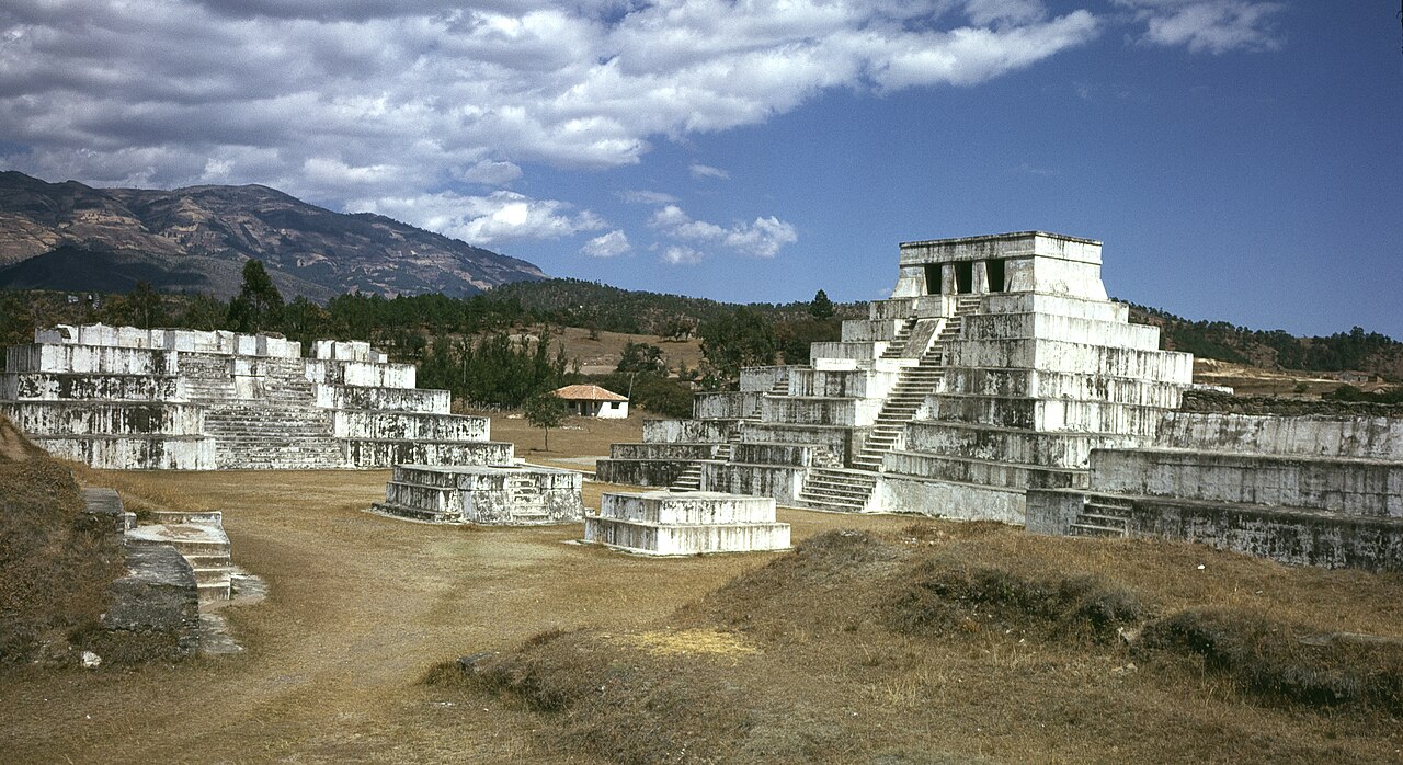 A cluster of squat white step pyramids, the tallest of them topped by a shrine with three doorways. In the background is a low mountain ridge. Zaculeu fell to Gonzalo de Alvarado y Contreras after a siege of several months. Although a state of hostilities existed between the Mam and the Kʼicheʼ of Qʼumarkaj after the rebellion of the Kaqchikel against their former Kʼicheʼ allies prior to European contact, when the conquistadors arrived there was a shift in the political landscape. Pedro de Alvarado described how the Mam king Kaybʼil Bʼalam was received with great honour in Qʼumarkaj while he was there.[122] The expedition against Zaculeu was apparently initiated after Kʼicheʼ bitterness at their failure to contain the Spanish at Qʼumarkaj, with the plan to trap the conquistadors in the city having been suggested to them by the Mam king, Kaybʼil Bʼalam; the resulting execution of the Kʼicheʼ kings was viewed as unjust. The Kʼicheʼ suggestion of marching on the Mam was quickly taken up by the Spanish.[123] At the time of the conquest, the main Mam population was situated in Xinabahul (also spelled Chinabjul), now the city of Huehuetenango, but Zaculeu's fortifications led to its use as a refuge during the conquest.[124] The refuge was attacked by Gonzalo de Alvarado y Contreras, brother of conquistador Pedro de Alvarado,[125] in 1525, with 40 Spanish cavalry and 80 Spanish infantry,[126] and some 2,000 Mexican and Kʼicheʼ allies.[127] Gonzalo de Alvarado left the Spanish camp at Tecpán Guatemala in July 1525 and marched to the town of Totonicapán, which he used as a supply base. From Totonicapán the expedition headed north to Momostenango, although it was delayed by heavy rains. Momostenango quickly fell to the Spanish after a four-hour battle. The following day Gonzalo de Alvarado marched on Huehuetenango and was confronted by a Mam army of 5,000 warriors from nearby Malacatán (modern Malacatancito). The Mam army advanced across the plain in battle formation and was met by a Spanish cavalry charge that threw them into disarray, with the infantry mopping up those Mam that survived the cavalry. Gonzalo de Alvarado slew the Mam leader Canil Acab with his lance, at which point the Mam army's resistance was broken, and the surviving warriors fled to the hills. Alvarado entered Malacatán unopposed to find it occupied only by the sick and the elderly. Messengers from the community's leaders arrived from the hills and offered their unconditional surrender, which was accepted by Alvarado. The Spanish army rested for a few days, then continued onwards to Huehuetenango only to find it deserted. Kaybʼil Bʼalam had received news of the Spanish advance and had withdrawn to his fortress at Zaculeu.[126] Alvarado sent a message to Zaculeu proposing terms for the peaceful surrender of the Mam king, who chose not to answer.[128] Zaculeu was defended by Kaybʼil Bʼalam[124] commanding some 6,000 warriors gathered from Huehuetenango, Zaculeu, Cuilco and Ixtahuacán. The fortress was surrounded on three sides by deep ravines and defended by a formidable system of walls and ditches. Gonzalo de Alvarado, although outnumbered two to one, decided to launch an assault on the weaker northern entrance. Mam warriors initially held the northern approaches against the Spanish infantry but fell back before repeated cavalry charges. The Mam defence was reinforced by an estimated 2,000 warriors from within Zaculeu but was unable to push the Spanish back. Kaybʼil Bʼalam, seeing that outright victory on an open battlefield was impossible, withdrew his army back within the safety of the walls. As Alvarado dug in and laid siege to the fortress, an army of approximately 8,000 Mam warriors descended on Zaculeu from the Cuchumatanes mountains to the north, drawn from those towns allied with the city.[129] Alvarado left Antonio de Salazar to supervise the siege and marched north to confront the Mam army.[130] The Mam army was disorganised, and although it was a match for the Spanish and allied foot soldiers, it was vulnerable to the repeated charges of the experienced Spanish cavalry. The relief army was broken and annihilated, allowing Alvarado to return to reinforce the siege.[131] After several months the Mam were reduced to starvation. Kaybʼil Bʼalam finally surrendered the city to the Spanish in the middle of October 1525.[132] When the Spanish entered the city they found 1,800 dead Indians, and the survivors eating the corpses of the dead.[127] After the fall of Zaculeu, a Spanish garrison was established at Huehuetenango under the command of Gonzalo de Solís; Gonzalo de Alvarado returned to Tecpán Guatemala to report his victory to his brother.[131] |
高地征服 グアテマラの高地は、南を太平洋の平野、南西を海岸に囲まれている。カクチケル王国は、西のアティトラン湖と東のグアテマラシティの中間地点にあるイシム チェを中心に栄えた。ツトゥヒル王国は、湖の南岸を中心に栄え、太平洋の低地にも広がっていた。ピピル族は太平洋平野に沿ってさらに東に位置し、ポコマム 族はグアテマラシティの東の高地に居住していた。キチェ族の王国は湖の北と西に広がり、主な居住地はシェラジュ、トトニカパン、クマルカ、ピスマチ、ジャ カウィッツであった。マム族の王国は、現在のメキシコに隣接する西の高地に広がっていた。 スペインによる征服前のグアテマラ高原の地図 高地征服は、中央メキシコで倒すべき強大な敵がいた場合とは異なり、この地域には多くの独立した政治体があったため、困難を極めた[73]。1521年に アステカの首都テノチティトランがスペイン軍に降伏した後、イシムチェのカクチケル・マヤ族は、 コルテスは、メキシコの新しい支配者に対する忠誠を宣言するために、イシムチェのカクチケル・マヤ族が特使を派遣した。また、クマルカジュのキチェ・マヤ 族も代表団を送った可能性がある[74]。1522年、コルテスはメキシコの同盟者をソコヌスコ地方(チアパス州)の低地地域を偵察に派遣し、彼らはイシ ムチェとクマルカジュから派遣された新たな代表団とトゥクスパンで会った[75]。 トゥクスパンでイシムチェとクマルカジャの新たな使節団と対面した[75]。両者の高地マヤ王国はスペイン王への忠誠を宣言した[74]。しかし、ソコヌ スコのコルテスの同盟者はすぐに、キチェとカクチケルは忠誠心はなく、その代わりにその地域のスペインの同盟者を困らせているとコルテスに報告した。コル テスは、ペドロ・デ・アルバラドに騎兵180名、歩兵300名、クロスボウ、マスケット銃、大砲4門、大量の弾薬と火薬、そしてメキシコ中央部のトラスカ ラ、チョルーラ、その他の都市から数千人の同盟メキシコ戦士を率いてソコヌスコに派遣することを決めた[76]。彼らは1523年にソコヌスコに到着した [74]。彼はテノチティトランのアステカの貴族虐殺で悪名高く、バルトロメ・デ・ラス・カサスによると、彼はグアテマラのマヤ王国征服でもさらなる残虐 行為を行ったという[77]。征服に屈服した後もスペインに忠誠を誓い続けたグループもあった。ケツァルテナンゴのツトゥヒル族やキチェ族などがその一例 であり、彼らはさらなる征服を支援するために戦士を提供した。しかし、他のグループはすぐに反乱を起こし、1526年までに多数の反乱が高地地域を覆って いた[78]。 キチェ族の征服 ケツァルテナンゴ征服を描いた『トラスカラ図絵』のページ ウルビナ平原、キチェ族との決戦が行われた場所 ... 彼らが矢を射るのに十分な距離まで近づいてくるのを待ち、そして彼らに突撃した。彼らは馬を見たことがなかったので非常に怯え、我々は大きく前進し...彼らの多くは死んだ。 ペドロ・デ・アルバラドは、エルナン・コルテスへの3通目の手紙の中で、ケツァルテナンゴへの進軍について述べている[79]。 ペドロ・デ・アルバラドとその軍隊は、グアテマラ西部のサマラ川に到着するまで、太平洋沿岸を抵抗を受けることなく進軍した。この地域はキチェ王国の一部 であり、キチェ軍はスペイン人が川を渡るのを阻止しようとしたが、失敗に終わった。川を渡った征服者たちは、キチェ族を威嚇しようと、近くの集落を略奪し た[5]。1524年2月8日、アルヴァラドの軍は、彼のメキシコ人同盟軍がザポティトラン(現在のサンフランシスコ・ザポティトラン)と呼んでいたケツ トゥルルで戦闘を行った。キチェ族の弓兵の攻撃により多くの負傷者が出たものの、スペイン軍とその同盟軍は町を急襲し、市場に野営地を構えた[80]。そ の後、アルヴァラドはキチェ族の中心地であるシエラマドレ山脈を目指して川を上り、ケツァルテナンゴの肥沃な谷へと続く峠を越えた。1524年2月12 日、アルヴァラドのメキシコ同盟軍は峠で待ち伏せされ、キチェ族の戦士たちに追い返された。しかし、それに続くスペイン騎兵隊の突撃は、それまで馬を見た ことがなかったキチェ族にとって衝撃的だった。騎兵隊はキチェ族を散らし、軍隊はケツァルテナンゴ(現在のケツァルテナンゴ)の町へ渡ったが、そこはすで に無人だった[81]。一般的な見解では、キチェ族の王子テクン・ウマンは、オリンテペケ近郊での後の戦闘で死亡したとされるが、スペイン側の記録では、 少なくとも1人、おそらく2人のクマルカフの領主が、ケツァルテナンゴへの最初の進軍時に起きた激しい戦闘で命を落としたことは、スペインの記録から明ら かである[82]。テクン・ウマンの死はエル・ピナルでの戦闘で起こったと言われている[83]。地元の伝承では、彼の死はケツァルテナンゴへの進軍時 に、カンテル村近くのウルビナ平野(Llanos de Urbina)で起こったとされている[84]。ウルビナ平野(Plains of Urbina)で、現在のカンテル村付近のケツァルテナンゴへの進軍中に亡くなったという説がある[84]。ペドロ・デ・アルバラドは、エルナン・コルテ スへの3通目の手紙の中で、ケツァルテナンゴへの進軍中にクマルカフの4人の領主のうち1人の死について述べている。この手紙は1524年4月11日付 で、Qʼumarkaj滞在中に書かれたものである[83]。ほぼ1週間後の1524年2月18日[85]、Kʼicheʼ軍はケツァルテナンゴ渓谷でス ペイン軍と対峙し、全面的に敗北した。キチェ族の死者の数が非常に多かったため、オリンテペケは「血にまみれた」という意味の「Xequiquel」とい う名前に変えられた[87]。17世紀初頭、キチェ族の王の孫は、アルカルデ・マヨール(当時の植民地政府最高責任者)に、クマルカハから侵略者と戦うた めに進軍したキチェ族の軍勢は3万人の戦士から成っていたと報告した。 侵略者と対決するためにクマルクから進軍したキチェ族の軍勢は3万人の戦士から成っていたと、キチェ族の王の孫は当時の最高植民地官であるアルカルデ・マ ヨールに報告した。この主張は現代の学者たちからも信憑性のあるものと見なされている[88]。この戦いでキチェ族は軍事的に疲弊し、和平と貢納を求め た。そして、スペイン人のナワトル語を話す同盟者たちにはテクパン・ウタトランとして知られていた首都クマルカハにペドロ・デ・アルバラドを招いた。アル ヴァラドはキチェ族の意図を深く疑っていたが、申し出を受け入れ、軍とともにクマルカハへと進軍した[89]。 オリンテペケの戦いの翌日、スペイン軍はツァカハに到着し、ツァカハは平和裏に降伏した。スペイン人司祭のフアン・ゴディネスとフアン・ディアスは、その 場しのぎの屋根の下でローマ・カトリックのミサを行った[90]。この場所はグアテマラで最初の教会を建てるために選ばれ[91]、コンセプシオン・ラ・ コンキスタドーラに捧げられた。ツァカハはサン・ルイス・サルカハと改名された[90]。グアテマラで初めて復活祭のミサが新しい教会で行われ、その間、 高位の先住民が洗礼を受けた[91]。 背後に広がる松林を背景に、草や低木に覆われた遺跡が見える。右奥には、崩れかけた四角い塔が建っている。これがトヒル神殿の唯一の遺構である。手前の左側にはボールコートの壁の跡がある。 クマルカは、スペインの侵略により焼失するまで、キチェ王国の首都であった。 1524年3月、ペドロ・デ・アルバラドはキチェ族の残存領主たちの招きに応じてクマルカに入城した。彼らは大敗北を喫した後、罠に嵌まることを恐れてい た[86]。彼は宿舎に入る代わりに、市外の平原に野営した[93]。市外には大勢のキチェ族戦士が集まっており、騎兵隊がクマルカの狭い路地で機動でき ないことを恐れた彼は、 クマルカジュの狭い路地で騎馬隊が機動できないことを懸念し、彼はクマルカジュの有力者、オキブ・ケ(アジョップ、つまり王)とベレヘブ・ツィ(アジョッ プ・カムハ、つまり次期王)を自分の陣営に招待した[94]。彼らがやってくるとすぐに、彼は彼らを捕らえて自分の陣営で囚人として監禁した。キチェ族の 戦士たちは、自分たちの主君たちが捕虜になったのを見て、スペイン人の先住民同盟軍を攻撃し、スペイン兵の1人を殺すことに成功した[95]。この時点 で、アルバラドは捕虜となったキチェ族の領主たちを火あぶりにして殺すことを決意し、その後 街全体を焼き払った[96]。クマルカジュの破壊と支配者の処刑の後、ペドロ・デ・アルバラドはカクチケルの首都イシムチェにメッセージを送り、残存する キチェ族の抵抗勢力に対する同盟を提案した。アルヴァラドは、4,000人の戦士を派遣して支援すると書いたが、カクチケルは400人しか派遣していない と記録している[89]。 サン・マルコス:テカスィトランとラカンドン地方 キチェ王国が降伏すると、キチェの支配下にあったキチェ族以外のさまざまな民族もスペインに降伏した。この中には、現在のサン・ペドロ・サカテペケス県 (San . Quetzaltenango)とサン・マルコス県(San Marcos)の地域に住むマム族も含まれていた。フアン・デ・レオン・イ・カルドナ(Juan de León y Cardona)の指揮下に入ったケツァルテナンゴとサン・マルコスでは、先住民人口の削減とスペイン人町建設が始まった。サン・マルコスとサン・ペド ロ・サカテペケスの町は、グアテマラ西部の征服直後に建設された[97]。1533年、ペドロ・デ・アルバラードはデ・レオン・イ・カルドナにタカナ、タ フムルコ、ラカンドン、サン・アントニオ火山周辺の地域を探索し征服するよう命じた。植民地時代、この地域はテクシトランとラカンドン州と呼ばれていた [98]。デ・レオンは、ナワトル語を話す同盟軍とともに、スペイン人50人を率いてケサリというマヤの都市へと進軍した。デ・レオンは、修道士ペドロ・ デ・アンゴロに敬意を表して、この都市をサン・ペドロ・サカテペケスと改名した[98]。スペイン人はその年の4月に、近くのカンダクチェクスに村を建設 し、サン・マルコスと改名した[99]。 カクチケル同盟 1524年4月14日、キチェ族の敗北直後、スペイン人はイシムチェに招かれ、領主ベレヘ・カットとカヒ・イモックスに歓待された[100][nb 3]。先住民兵士を提供し、コンキスタドールがキチェ族の抵抗を続けるのを助け、近隣のツトゥヒル王国の討伐を支援した[101]。スペイン人はイシム チェに短期間滞在した後、アティトラン、エスクイントラ、クスカトランを経て進軍した。スペイン人は1524年7月23日にカクチケル王国の首都に戻っ た。そして7月27日(カクチケル暦の1Qʼat)にペドロ・デ・アルバラドが、イシムチェをグアテマラの最初の首都、サンティアゴ・デ・ロス・カバリェ ロス・デ・グアテマラ(「グアテマラ騎士団の聖ヤコブ」)と宣言した。グアテマラ、サンティアゴ・デ・ロス・カバリェロス・デ・グアテマラ(「グアテマラ 騎士団の聖ヤコブ」)。[102] イシムチェは、スペイン人によってグアテマラと呼ばれた。これはナワトル語で「森林地帯」を意味するクアウテマランに由来する。スペインの征服者たちがイ シムチェに最初の首都を建設して以来、彼らはナワトル語を話すメキシコの同盟者が使用していた都市の名前を取り、それを新しいスペインの都市、ひいては王 国にも適用した。これが現在の国名の由来である[103]。ペドロ・デ・アルバラードが軍をイシムチェに移動させた際、彼は敗北したキチェ王国をフアン・ デ・レオン・イ・カルドナの指揮下に置いた[104]。デ・レオン・イ・カルドナは新植民地の西部の指揮を任されたが、ポコムの首都への攻撃など、続く征 服に積極的に関与し続けた[105]。 ツトゥヒル族の征服 丘陵地帯から、薄霧に包まれた広大な湖が見渡せる。山がちな湖岸は、手前の左側から奥、そして右へと湾曲しており、その向こう岸にはいくつもの火山がそびえ、青空が背景となっている。 ツツジル王国は、アティトラン湖の湖畔に都を置いていた。 カクチケル族は、敵であるツツジル族(首都はテクパン・アティトラン)を討伐するためにスペイン人と同盟を結んだようである[89]。ペドロ・デ・アルバ ラドは、カクチケル族の領主の要請により、2人のカクチケル族の使者をテクパン・アティトランに派遣したが、2人ともツツジル族に殺害された[106]。 ] 使者の殺害の知らせがイシムチェのスペイン人に届いたとき、コンキスタドールたちはカクチケル族の同盟軍とともにツトゥジル族に戦いを挑んだ[89]。ペ ドロ・デ・アルバラドは、到着からわずか5日後にイシムチェを去った。60人の騎兵、150人のスペイン人歩兵、そして不明数のカクチケル族戦士を率い て。スペイン人とその同盟軍は、1日かけて湖畔に到着したが、抵抗に遭うことはなかった。抵抗がないことを見て、アルバラドは30人の騎兵とともに湖畔を 進んだ。人口の多い島に差し掛かったところで、スペイン軍はついに敵対的なツツジルの戦士たちと遭遇し、彼らの中に突撃した。生き残ったツツジル族は狭い 土手道に逃げ込んだが、スペイン軍は彼らを追い散らし、追跡した[107]。馬が通れるほど広くはなかったため、征服者たちは馬から降りて橋を壊される前 に島に渡った[108]。アルヴァラドの軍隊の残りがすぐに彼の部隊を補強し、彼らは島をうまく攻略した。生き残ったツトゥヒル族は湖に逃げ込み、別の島 まで泳いで逃げ延びた。スペイン軍は、カクチケル族が送った300隻のカヌーがまだ到着していなかったため、生存者をそれ以上追うことができなかった。こ の戦いは4月18日に起こった[109]。 翌日、スペイン軍はテプパン・アティトランに入城したが、そこには誰もいなかった。ペドロ・デ・アルバラドは町の中心部に野営し、敵を見つけるために斥候 を派遣した。彼らは何人かの地元民を捕らえることに成功し、ツツジル族の首長にスペイン王に服従するよう命じるメッセージを伝えるために彼らを利用した。 ツトゥヒル族の首長は、ペドロ・デ・アルバラドに降伏し、スペインへの忠誠を誓うことでこれに答えた。アルバラドはこれでツトゥヒル族を平定したと考え、 イシムチェに戻った[109]。ペドロ・デ・アルバラドがイシムチェに戻ってから3日後、ツトゥヒル族の首長が到着し、征服者たちに忠誠を誓い、貢物を献 上した[110]。その後まもなく、太平洋低地からスペイン王への忠誠を誓うために多くの領主たちが到着したが、アルヴァラドはその手紙の中で彼らの名前 には触れていない。彼らは、ナワトル語でイスクインテペケ、またはカクチケル語でパナタックと呼ばれる王国が太平洋平原のさらに奥にあるというカクチケル の報告を確認した。その王国は好戦的で、近隣諸国に対して敵対的だった。 カクチケル族の反乱 きれいに整備された一連の低地遺跡を見渡す。重なり合う長方形の基底プラットフォームが迷路のように連なっている。2つの小さなピラミッド状の建造物が視界を支配し、松林がその背景となっている。 スペインの脱走兵によって焼かれたイシムチェの遺跡 馬に乗ったコンキスタドールが右に突進し、羽飾りのついた戦闘服を着た2人の先住民が徒歩で従っている。右側には、より簡素な服装の先住民が攻撃者に矢を放っている。 イシムチェ征服を描いたトラスカラ図の1ページ ペドロ・デ・アルバラドはカクチケル族に貢納金として金を要求し始め、両民族の友好関係を悪化させた[112]。彼は彼らの王に、1枚15ペソの金貨1000枚を納めるよう要求した[113][nb 4]。 カクチケル族の神官は、カクチケル族の神々がスペイン人を滅ぼすだろうと予言し、1524年8月28日(カクチケル暦ではアマク7日)、カクチケル族は自 分たちの都市を捨て、森や丘へと逃げた。10日後、スペインはカクチケルに宣戦布告した[112]。2年後、1526年2月9日、16人のスペインの脱走 兵がアポ・シャヒルの宮殿を焼き、寺院を略奪し、司祭を誘拐した。カクチケルはこれらの行為をペドロ・デ・アルバラドのせいだとした[114][nb 5]。[114][nb 5] 征服者ベルナル・ディアス・デル・カスティージョは、1526年にイシムチェに戻り、ルイス・マリンやエルナン・コルテスのホンジュラス遠征隊の他のメン バーとともに「グアテマラの旧市街」で夜を過ごしたときの様子を語っている。彼は、この都市の建物は今でも良好な状態であると報告した。彼の記述は、この 都市がまだ居住可能であった最後の記述となった[115]。 カクチケル族はスペイン人と戦いを始めた。彼らは馬用の穴や落とし穴を開け、鋭い杭を打ち込んで馬を殺した。多くのスペイン人と彼らの馬が馬用の落とし穴で死んだ。多くのキチェ族とツツジル族も死んだ。こうしてカクチケル族はこれらの民族をすべて滅ぼした。 カクチケル族年代記[116] スペイン人はグアテマラのテパン近郊に新しい町を建設した。テパンはナワトル語で「宮殿」を意味し、新しい町の名前は「森の中の宮殿」と訳された [117]。スペイン人はカクチケルの攻撃が絶えなかったため、1527年にテパンを放棄し、東にあるアルモロンガ渓谷に移り、現在のサン・ミゲル・エス コバル地区(シウダー・ビエハの近く)に首都を再建した 、グアテマラのアンティグア近郊である[118]。スペインと同盟を結んだナワ族とオアハカ族は、現在のシウダービエハの中心部に定住した。当時はアルモ ロンガと呼ばれていたが(ケツァルテナンゴ近郊のアルモロンガと混同しないように)[119]、サポテカ族とミシュテカ族もアルモロンガの北東約2キロ メートルにあるサン・ガスパル・ビバルに定住した。彼らは1530年にこの地を建設した[120]。 カクチケル族はスペイン人に対して長年にわたり抵抗を続けたが、1530年5月9日、最も優れた戦士たちの死や作物の放棄を余儀なくされた戦いに疲れ果て た2人の族長の王が、荒野から戻ってきた[112]。その翌日、多くの貴族とその家族、さらに多くの人々が合流。そして、彼らはスペインの新しい首都シウ ダー・ビエハに降伏した[112]。イシムチェの住民は散り散りになり、一部はテクパンに移住し、残りはソロラやアティトラン湖周辺の他の町に移住した [117]。 サクレウの包囲 背の低い白い階段ピラミッドの集まり。最も高いピラミッドの頂上には、3つの出入り口がある神殿がある。背景には低い山稜が見える。 数か月にわたる包囲戦の末、ザクレウはゴンサロ・デ・アルバラド・イ・コントレラスに降伏した。 ヨーロッパ人が到着する以前、カクチケル族がかつての同盟国キチェ族に反乱を起こしたため、マム族とクマルカフのキチェ族の間に敵対状態が存在したが、征 服者が到着すると政治情勢に変化が生じた。ペドロ・デ・アルバラドは、彼がクマルカージに滞在していた間、マムの王ケイビル・バラムがクマルカージでいか に丁重にもてなされたかを述べている[122]。ザクルウに対する遠征は、どうやら、スペイン人をクマルカージで封じ込めることに失敗したキチェ族の恨み を買ったことがきっかけで始まった。征服者をクマルカージに閉じ込めるという計画は、マム王のカイビル・バラムによって彼らに提案されていた。その結果、 キチェ族の王たちが処刑されたことは不当であると見なされた。キチェ族のマン族への進軍提案は、スペイン人によりすぐに採用された[123]。 征服当時、マムの主な人口は、現在のウエウエテナンゴ市であるシナバフル(Chinabjulとも綴られる)に居住していたが、ザクルエの要塞が征服時の 避難場所として利用された[124]。この避難場所は、征服者ペドロ・デ・アルバラドの兄弟ゴンサロ・デ・アルバラド・イ・コントレラスによって、 1525年、40人のスペイン騎兵と80人のスペイン歩兵、約2,000人のメキシコ人とキチェ族の同盟軍を率いて攻撃した[126][127]。ゴンサ ロ・デ・アルバラドは1525年7月にグアテマラのテクパンにあるスペイン軍の野営地を離れ、物資補給基地として使うトトニカパンという町まで進軍した。 トトニカパンから遠征隊は北のモモステナンゴを目指したが、激しい雨のために遅れた。モモステナンゴは4時間の戦闘の末、スペイン軍に簡単に陥落した。翌 日、ゴンサロ・デ・アルバラドはウエウエテナンゴに進軍し、近くのマラカタン(現在のマラカタンシト)から来た5,000人のマム族の軍勢と対峙した。マ ム軍は戦列を組んで平原を進み、スペイン騎兵隊の突撃に遭遇し混乱に陥った。騎兵隊を生き延びたマム兵は歩兵隊に掃討された。ゴンサロ・デ・アルバラドは 槍でマム軍のリーダー、カニル・アカブを殺し、マム軍の抵抗は壊滅した。生き残った戦士たちは丘に逃げた。アルバラドは抵抗を受けることなくマラカタンに 入ったが、そこには病人や年老いた人々しかいなかった。丘陵地帯からやってきたコミュニティの指導者からの使者が無条件降伏を申し出て、アルヴァラドはこ れを受け入れた。スペイン軍は数日間休息した後、フエフテナンゴへと進んだが、そこはすでに無人だった。ケイビル・バラムはスペイン軍の進撃の知らせを受 け、ザクルエの要塞に撤退していた[126]。アルヴァラドはザクルエに、マムの王が平和的に降伏するための条件を提示するメッセージを送ったが、王はそ れに応えることはなかった[128]。 ザクレウは、フエフテナンゴ、ザクレウ、クイルコ、イクスタワカンから集められた約6,000人の戦士を指揮するカイビル・バラムによって守られていた。 要塞は深い峡谷によって3方を囲まれており、強固な城壁と堀によって守られていた。ゴンサロ・デ・アルバラドは、2対1という劣勢にもかかわらず、より防 御力の弱い北側の入口を攻撃することにした。マムの戦士たちは、スペインの歩兵部隊に対して北側の出入口を守っていたが、騎兵隊の反復攻撃の前に後退し た。マムの防衛は、ザクルエ内の推定2,000人の戦士によって強化されたが、スペイン軍を押し返すことはできなかった。カイル・ビ・ラムは、開けた戦場 で決定的な勝利を収めることは不可能だと判断し、軍隊を城壁内の安全な場所へと撤退させた。アルヴァラドが要塞を掘り、包囲網を敷く中、マム族の戦士約 8,000人が、ザクルエと同盟を結んでいる町々から北のクチュマタン山脈に降りてきた[129]。 アルヴァルドはアントニオ・デ・サラザールに攻城戦を指揮させ、マム軍と対決するために北進した[130]。マム軍は組織化されておらず、スペイン軍や同 盟国の歩兵には対抗できたが、経験豊富なスペイン騎兵隊の繰り返し攻撃には無力だった。救援軍は壊滅し、アルヴァラドが包囲戦を強化するために戻ってくる ことを可能にした[131]。数か月後、マム族は飢餓状態に陥った。1525年10月中旬、カイビル・バラムはついにスペイン軍に降伏した[132]。ス ペイン軍が街に入ると、1,800人のインディオの死体と、死体の遺体を食べている生存者たちがいた [127] ザクルエの陥落後、ゴンサロ・デ・ソリス指揮下のスペイン守備隊がフエウテナンゴに置かれた。ゴンサロ・デ・アルバラドはテクパン・グアテマラに戻り、兄 に勝利を報告した[131]。 |
| Conquest of the Poqomam n 1525 Pedro de Alvarado sent a small company to conquer Mixco Viejo (Chinautla Viejo), the capital of the Poqomam.[nb 6] At the Spanish approach, the inhabitants remained enclosed in the fortified city. The Spanish attempted an approach from the west through a narrow pass but were forced back with heavy losses. Alvarado himself launched the second assault with 200 Tlaxcalan allies but was also beaten back. The Poqomam then received reinforcements, possibly from Chinautla, and the two armies clashed on open ground outside of the city. The battle was chaotic and lasted for most of the day but was finally decided by the Spanish cavalry, forcing the Poqomam reinforcements to withdraw.[133] The leaders of the reinforcements surrendered to the Spanish three days after their retreat and revealed that the city had a secret entrance in the form of a cave leading up from a nearby river, allowing the inhabitants to come and go.[134] Armed with the knowledge gained from their prisoners, Alvarado sent 40 men to cover the exit from the cave and launched another assault along the ravine from the west, in single file owing to its narrowness, with crossbowmen alternating with soldiers bearing muskets, each with a companion sheltering him from arrows and stones with a shield. This tactic allowed the Spanish to break through the pass and storm the entrance of the city. The Poqomam warriors fell back in disorder in a chaotic retreat through the city, and were hunted down by the victorious conquistadors and their allies. Those who managed to retreat down the neighbouring valley were ambushed by Spanish cavalry who had been posted to block the exit from the cave, the survivors were captured and brought back to the city. The siege had lasted more than a month and because of the defensive strength of the city, Alvarado ordered it to be burned and moved the inhabitants to the new colonial village of Mixco.[133] Resettlement of the Chajoma There are no direct sources describing the conquest of the Chajoma by the Spanish but it appears to have been a drawn-out campaign rather than a rapid victory.[135] The only description of the conquest of the Chajoma is a secondary account appearing in the work of Francisco Antonio de Fuentes y Guzmán in the 17th century, long after the event.[136] After the conquest, the inhabitants of the eastern part of the kingdom were relocated by the conquerors to San Pedro Sacatepéquez, including some of the inhabitants of the archaeological site now known as Mixco Viejo (Jilotepeque Viejo).[nb 6] The rest of the population of Mixco Viejo, together with the inhabitants of the western part of the kingdom, were moved to San Martín Jilotepeque.[135] The Chajoma rebelled against the Spanish in 1526, fighting a battle at Ukubʼil, an unidentified site somewhere near the modern towns of San Juan Sacatepéquez and San Pedro Sacatepéquez.[137][nb 7] In the colonial period, most of the surviving Chajoma were forcibly settled in the towns of San Juan Sacatepéquez, San Pedro Sacatepéquez and San Martín Jilotepeque as a result of the Spanish policy of congregaciones; the people were moved to whichever of the three towns was closest to their pre-conquest land holdings. Some Iximche Kaqchikels seem also to have been relocated to the same towns.[138] After their relocation some of the Chajoma drifted back to their pre-conquest centres, creating informal settlements and provoking hostilities with the Poqomam of Mixco and Chinautla along the former border between the pre-Columbian kingdoms. Some of these settlements eventually received official recognition, such as San Raimundo near Sacul.[136] El Progreso and Zacapa The Spanish colonial corregimiento of San Cristóbal Acasaguastlán was established in 1551 with its seat in the town of that name, now in the eastern portion of the modern department of El Progreso.[139] Acasaguastlán was one of few pre-conquest centres of population in the middle Motagua River drainage, due to the arid climate.[140] It covered a broad area that included Cubulco, Rabinal, and Salamá (all in Baja Verapaz), San Agustín de la Real Corona (modern San Agustín Acasaguastlán) and La Magdalena in El Progreso, and Chimalapa, Gualán, Usumatlán and Zacapa, all in the department of Zacapa.[139] Chimalapa, Gualán and Usumatlán were all satellite settlements of Acasaguastlán.[140] San Cristóbal Acasaguastlán and the surrounding area were reduced into colonial settlements by friars of the Dominican Order; at the time of the conquest the area was inhabited by Poqomchiʼ Maya and by the Nahuatl-speaking Pipil.[139] In the 1520s, immediately after conquest, the inhabitants paid taxes to the Spanish Crown in the form of cacao, textiles, gold, silver and slaves. Within a few decades taxes were instead paid in beans, cotton and maize.[140] Acasaguastlán was first given in encomienda to conquistador Diego Salvatierra in 1526.[141] Chiquimula Chiquimula de la Sierra ("Chiquimula in the Highlands"), occupying the area of the modern department of Chiquimula to the east of the Poqomam and Chajoma, was inhabited by Chʼortiʼ Maya at the time of the conquest.[142] The first Spanish reconnaissance of this region took place in 1524 by an expedition that included Hernando de Chávez, Juan Durán, Bartolomé Becerra and Cristóbal Salvatierra, amongst others.[143] In 1526 three Spanish captains, Juan Pérez Dardón, Sancho de Barahona and Bartolomé Becerra, invaded Chiquimula on the orders of Pedro de Alvarado. The indigenous population soon rebelled against excessive Spanish demands, but the rebellion was quickly put down in April 1530.[144] However, the region was not considered fully conquered until a campaign by Jorge de Bocanegra in 1531–1532 that also took in parts of Jalapa.[143] The afflictions of Old World diseases, war and overwork in the mines and encomiendas took a heavy toll on the inhabitants of eastern Guatemala, to the extent that indigenous population levels never recovered to their pre-conquest levels.[145] Campaigns in the Cuchumatanes 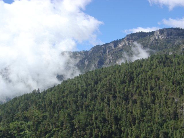 View over a heavily forested mountain slope towards rugged peaks beyond, separated from them by a mass of low cloud. The difficult terrain and remoteness of the Cuchumatanes made their conquest difficult. In the ten years after the fall of Zaculeu various Spanish expeditions crossed into the Sierra de los Cuchumatanes and engaged in the gradual and complex conquest of the Chuj and Qʼanjobʼal.[146] The Spanish were attracted to the region in the hope of extracting gold, silver and other riches from the mountains but their remoteness, the difficult terrain and relatively low population made their conquest and exploitation extremely difficult.[147] The population of the Cuchumatanes is estimated to have been 260,000 before European contact. By the time the Spanish physically arrived in the region this had collapsed to 150,000 because of the effects of the Old World diseases that had run ahead of them.[69] Uspantán and the Ixil After the western portion of the Cuchumatanes fell to the Spanish, the Ixil and Uspantek Maya were sufficiently isolated to evade immediate Spanish attention. The Uspantek and the Ixil were allies and in 1529, four years after the conquest of Huehuetenango, Uspantek warriors were harassing Spanish forces and Uspantán was trying to foment rebellion among the Kʼicheʼ. Uspantek activity became sufficiently troublesome that the Spanish decided that military action was necessary. Gaspar Arias, magistrate of Guatemala, penetrated the eastern Cuchumatanes with 60 Spanish infantry and 300 allied indigenous warriors.[131] By early September he had imposed temporary Spanish authority over the Ixil towns of Chajul and Nebaj.[148] The Spanish army then marched east toward Uspantán itself; Arias then received notice that the acting governor of Guatemala, Francisco de Orduña, had deposed him as magistrate. Arias handed command over to the inexperienced Pedro de Olmos and returned to confront de Orduña. Although his officers advised against it, Olmos launched a disastrous full-scale frontal assault on the city. As soon as the Spanish began their assault they were ambushed from the rear by more than 2,000 Uspantek warriors. The Spanish forces were routed with heavy losses; many of their indigenous allies were slain, and many more were captured alive by the Uspantek warriors only to be sacrificed on the altar of their deity Exbalamquen. The survivors who managed to evade capture fought their way back to the Spanish garrison at Qʼumarkaj.[149]   A year later Francisco de Castellanos set out from Santiago de los Caballeros de Guatemala (by now relocated to Ciudad Vieja) on another expedition against the Ixil and Uspantek, leading 8 corporals, 32 cavalry, 40 Spanish infantry and several hundred allied indigenous warriors. The expedition rested at Chichicastenango and recruited further forces before marching seven leagues northwards to Sacapulas and climbed the steep southern slopes of the Cuchumatanes. On the upper slopes they clashed with a force of 4,000-5,000 Ixil warriors from Nebaj and nearby settlements. A lengthy battle followed during which the Spanish cavalry managed to outflank the Ixil army and forced them to retreat to their mountaintop fortress at Nebaj. The Spanish force besieged the city, and their indigenous allies managed to scale the walls, penetrate the stronghold and set it on fire. Many defending Ixil warriors withdrew to fight the fire, which allowed the Spanish to storm the entrance and break the defences.[149] The victorious Spanish rounded up the surviving defenders and the next day Castellanos ordered them all to be branded as slaves as punishment for their resistance.[150] The inhabitants of Chajul immediately capitulated to the Spanish as soon as news of the battle reached them. The Spanish continued east towards Uspantán to find it defended by 10,000 warriors, including forces from Cotzal, Cunén, Sacapulas and Verapaz. The Spaniards were barely able to organise a defence before the defending army attacked. Although heavily outnumbered, the deployment of Spanish cavalry and the firearms of the Spanish infantry eventually decided the battle. The Spanish overran Uspantán and again branded all surviving warriors as slaves. The surrounding towns also surrendered, and December 1530 marked the end of the military stage of the conquest of the Cuchumatanes.[151] Reduction of the Chuj and Qʼanjobʼal 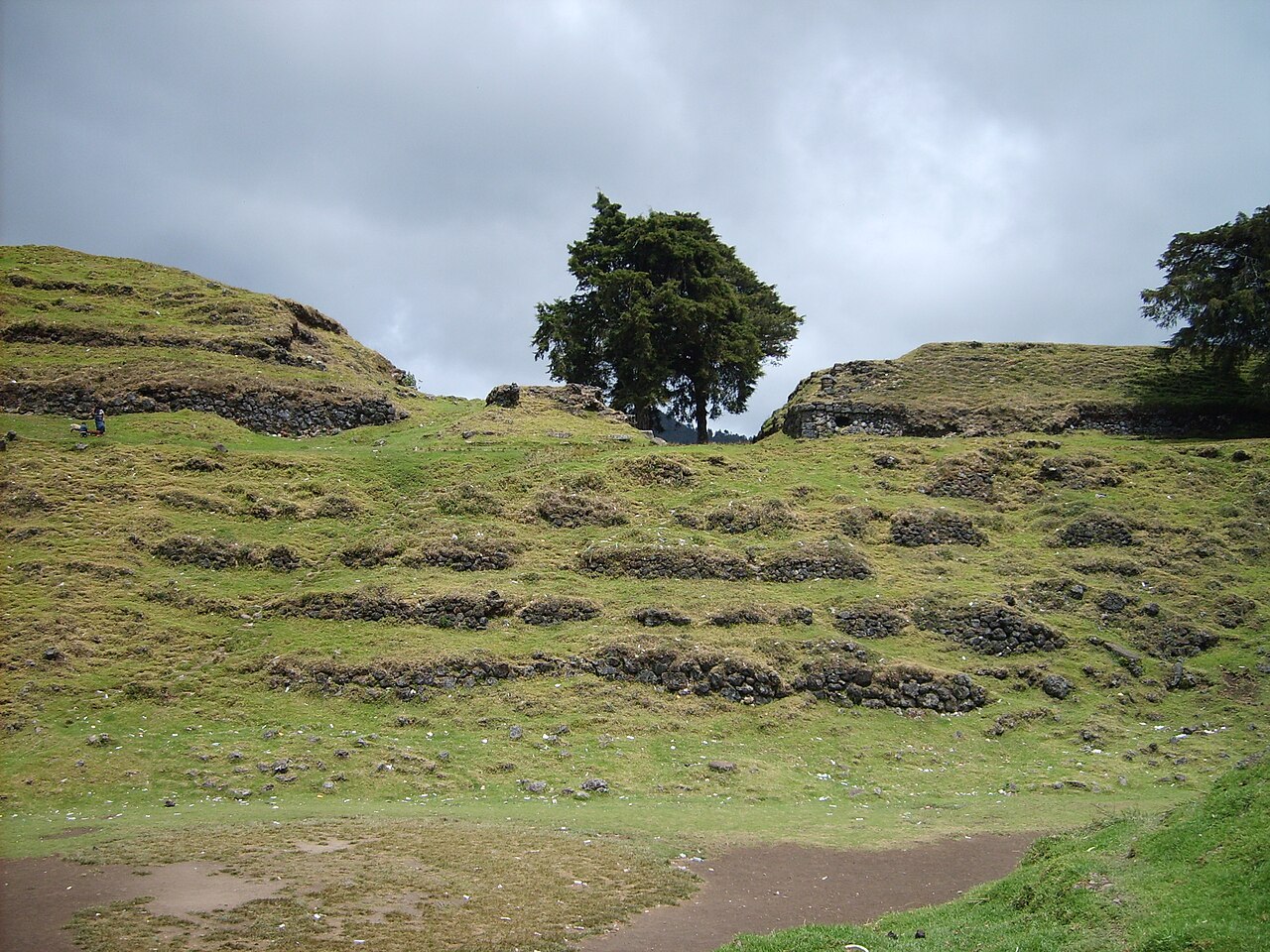 In 1529 the Chuj city of San Mateo Ixtatán (then known by the name of Ystapalapán) was given in encomienda to the conquistador Gonzalo de Ovalle, a companion of Pedro de Alvarado, together with Santa Eulalia and Jacaltenango. In 1549, the first reduction (reducción in Spanish) of San Mateo Ixtatán took place, overseen by Dominican missionaries,[152] in the same year the Qʼanjobʼal reducción settlement of Santa Eulalia was founded. Further Qʼanjobʼal reducciones were in place at San Pedro Soloma, San Juan Ixcoy and San Miguel Acatán by 1560. Qʼanjobʼal resistance was largely passive, based on withdrawal to the inaccessible mountains and forests from the Spanish reducciones. In 1586 the Mercedarian Order built the first church in Santa Eulalia.[62] The Chuj of San Mateo Ixtatán remained rebellious and resisted Spanish control for longer than their highland neighbours, resistance that was possible owing to their alliance with the lowland Lakandon Chʼol to the north. The continued resistance was so determined that the Chuj remained pacified only while the immediate effects of the Spanish expeditions lasted.[153] In the late 17th century, the Spanish missionary Fray Alonso de León reported that about eighty families in San Mateo Ixtatán did not pay tribute to the Spanish Crown or attend the Roman Catholic mass. He described the inhabitants as quarrelsome and complained that they had built a pagan shrine in the hills among the ruins of pre-Columbian temples, where they burnt incense and offerings and sacrificed turkeys. He reported that every March they built bonfires around wooden crosses about two leagues from the town and set them on fire. Fray de León informed the colonial authorities that the practices of the natives were such that they were Christian in name only. Eventually, Fray de León was chased out of San Mateo Ixtatán by the locals.[154] A series of semi-collapsed dry-stone terraces, overgrown with short grass. On top of the uppermost of five terraces stand the crumbling, overgrown remains of two large buildings flanking the ruins of a smaller structure. A tree grows from the right hand side of the smaller central building, and another stands in at extreme right, on the upper terrace and in front of the building also standing on it. The foreground is a flat plaza area, with the collapsed flank of a grass-covered pyramid at bottom right. The sky is overcast with low rainclouds. The ruins of Ystapalapán In 1684, a council led by Enrique Enríquez de Guzmán, the governor of Guatemala, decided on the reduction of San Mateo Ixtatán and nearby Santa Eulalia, both within the colonial administrative district of the Corregimiento of Huehuetenango.[155] On 29 January 1686, Captain Melchor Rodríguez Mazariegos, acting under orders from the governor, left Huehuetenango for San Mateo Ixtatán, where he recruited indigenous warriors from the nearby villages, 61 from San Mateo itself.[156] It was believed by the Spanish colonial authorities that the inhabitants of San Mateo Ixtatán were friendly towards the still unconquered and fiercely hostile inhabitants of the Lacandon region, which included parts of what is now the Mexican state of Chiapas and the western part of the Petén Basin.[157] To prevent news of the Spanish advance reaching the inhabitants of the Lacandon area, the governor ordered the capture of three of San Mateo's community leaders, named as Cristóbal Domingo, Alonso Delgado and Gaspar Jorge, and had them sent under guard to be imprisoned in Huehuetenango.[158] The governor himself arrived in San Mateo Ixtatán on 3 February, where Captain Rodríguez Mazariegos was already awaiting him. The governor ordered the captain to remain in the village and use it as a base of operations for penetrating the Lacandon region. The Spanish missionaries Fray de Rivas and Fray Pedro de la Concepción also remained in the town.[159] Governor Enriquez de Guzmán subsequently left San Mateo Ixtatán for Comitán in Chiapas, to enter the Lacandon region via Ocosingo.[160] In 1695, a three-way invasion of the Lacandon was launched simultaneously from San Mateo Ixtatán, Cobán and Ocosingo.[161] Captain Rodriguez Mazariegos, accompanied by Fray de Rivas and 6 other missionaries together with 50 Spanish soldiers, left Huehuetenango for San Mateo Ixtatán.[162] Following the same route used in 1686,[161] they managed on the way to recruit 200 indigenous Maya warriors from Santa Eulalia, San Juan Solomá and San Mateo itself.[162] On 28 February 1695, all three groups left their respective bases of operations to conquer the Lacandon. The San Mateo group headed northeast into the Lacandon Jungle.[162] |
ポコマムの征服 1525年、ペドロ・デ・アルバラードは、ポコマムの首都ミクソ・ビエホ(チャイヌトラ・ビエホ)を征服するために、少人数の部隊を派遣した[注6]。ス ペイン軍が接近しても、住民は要塞化された都市内に閉じこもっていた。スペイン軍は狭い峠道を通って西側から接近を試みたが、大きな損失を被って撤退を余 儀なくされた。アルバラード自身は、200人のトラスカランの同盟軍とともに2度目の攻撃を仕掛けたが、これも撃退された。ポコマムはその後、おそらく チャイヌトラから援軍を受け、2つの軍隊は街の郊外の開けた場所で激突した。戦闘は混乱を極め、ほぼ一日中続いたが、最終的にスペイン騎兵隊が勝利し、ポ コマムの援軍は撤退を余儀なくされた[133]。援軍の指揮官たちは撤退から3日後にスペイン軍に降伏し、この街には近くの川から続く洞窟のような秘密の 入り口があり、住民が出入りできることを明らかにした [134] 捕虜から得た情報をもとに、アルバラドは40人の兵士を洞窟の出口に配備し、峡谷に沿って西側から狭い谷間を1列縦隊で進み、クロスボウ兵とマスケット銃 兵を交互に配置し、それぞれ盾で矢や石から身を守る仲間を従えた。この戦術により、スペイン軍は峠を突破し、都市の入口を襲撃することができた。ポコマム の戦士たちは混乱した撤退を行い、都市を抜けながら無秩序に後退し、勝利を収めた征服者とその同盟軍に追いつめられた。 近くの谷に撤退することができた者たちは、洞窟の出口を封鎖するために配置されたスペイン騎兵隊の待ち伏せに遭い、生き残った者も捕らえられ、都市に戻さ れた。包囲は1か月以上続き、この都市の防衛力の強さを考慮して、アルバラドは都市を焼き払い、住民を新しい植民地都市ミクソに移住させた[133]。 チャヨマの再定住 スペインによるチャヨマ征服を直接的に描写した資料はないが、それは短期間で勝利を収めたというよりも、長期にわたる戦役であったようだ[135]。チャ ヨマ征服に関する唯一の記述は、17世紀にフランシスコ・アントニオ・デ・フエンテス・イ・グスマンが著した作品に書かれた二次的な記録であり、事件から かなり時間が経ってから書かれたものである[136]。征服後、王国の東部に住んでいた住民は征服者によってサン・ペドロ・サカテペケスに移住させられ、 その中には現在ミクソ・ビエホ(Jilot [nb 6] ミクソ・ビエホの残りの住民と王国の西部の住民は、サン・マルティン・ヒロテペケに移住した[135]。チャホマは1526年にスペインに反抗し、ウクビ ルで戦いを交えた。ウクビルは、現在のサン・フアン・サカテペケスとサン・ペドロ・サカテペケスの町の近くにある未確認の遺跡である[137][nb 7]。[137][nb 7] 植民地時代、スペインの政策である集合村(congregaciones)により、生き残ったチャヨマのほとんどはサン・フアン・サカテペケス、サン・ペ ドロ・サカテペケス、サン・マルティン・ヒロテペケスの3つの町に強制的に移住させられた。人々は、征服前の土地所有地から最も近い町に移住させられた。 一部のイシムチェ・カクチケル族も、同じ町に移住させられたようだ[138]。移住後、チャヨマ族の一部は征服前の拠点に戻ったが、非公式の集落を作り、 先コロンブス期王国の間の旧国境沿いにあるミクソとチナウトラのポコム族との敵対関係を引き起こした。これらの入植地のいくつかは、最終的に公式に認めら れた。例えば、サクル近郊のサン・ライムンドなどがそうだ[136]。 エル・プログレソとサカパ スペイン植民地時代のサン・クリストバル・アカサグアスタラン郡は、1551年に現在のエル・プログレソ県東部に位置する同名の町に設立された [139]。アカサグアスタランは、乾燥した気候のため、モタグア川流域中流の植民地化以前の人口集中地のひとつであった[140]。この地域は広範囲に 及び、バハ・ベラパス州のクブルコ、ラビナル、サラマ、サン・アグスティン・デ・ラ・レアル・コロナ(現在のサン・アグスティン・アカサグアスタラン)、 エル・プログレソのラ・マグダレーナ、ザカパ県のチマラパ、グアラン、ウスマトラン、ザカパを含んでいた[139]。マグダレナ(El Progreso)、チマラパ、グアラン、ウスマトラン、ザカパ(いずれもザカパ県)などである[139]。チマラパ、グアラン、ウスマトランは、いずれ もアカサグアスタランの衛星都市であった[140]。サン・クリストバル・アカサグアスタランとその周辺地域は、ドミニコ会の修道士たちによって植民地化 された。ドミニコ修道会の修道士たちによって植民地化された。征服当時、この地域にはポコムチ・マヤ族とナワトル語を話すピピル族が住んでいた [139]。1520年代、征服直後、住民たちはスペイン王室にカカオ、織物、金、銀、奴隷を税として納めていた。数十年後には、代わりに豆、綿、トウモ ロコシが税として支払われるようになった[140]。アカサグアスランは、1526年に征服者ディエゴ・サルバティエラにエンコミエンダとして与えられた [141]。 チキムラ チキムラ・デ・ラ・シエラ(「高地にあるチキムラ」)は、 ポコムアムとチャホマの東に位置する現在のチクムラ県の地域を占領したチクムラ・デ・ラ・シエラ(「高地にあるチクムラ」)は、征服当時、チョルティ・マ ヤ族が居住していた[142]。この地域を初めてスペインが偵察したのは1524年のことで、エルナンド・デ・チャベス 、フアン・ドゥラン、バルトロメ・ベセラ、クリストバル・サルバティエラなどを含む遠征隊によって行われた[143]。1526年には、ペドロ・デ・アル バラドの命令により、フアン・ペレス・ダルドン、サンチョ・デ・バラオナ、バルトロメ・ベセラの3人のスペイン人船長がチキムラに侵攻した。先住民はすぐ にスペインの過度な要求に反発したが、1530年4月にすぐに鎮圧された[144]。しかし、この地域が完全に征服されたと考えられたのは、1531年か ら1532年にかけてのホルヘ・デ・ボカネグラによるキャンペーンで、 ハラパの一部も占領した[143]。旧世界の病気、戦争、鉱山やエンコミエンダでの過酷な労働は、グアテマラ東部の住民に多大な犠牲を強いた。その結果、 先住民人口は征服前のレベルに回復することはなかった[145]。 クチュマタンでの遠征 険しい峰々を望む、鬱蒼とした山肌の斜面。 険しい地形とクチュマタンが隔てられた遠隔地であることから、その征服は困難を極めた。 ザクルエの陥落から10年間にわたり、スペインのさまざまな探検隊がシエラ・デ・ロス・クチュマタンに侵入し、チュウとカンジョバル族の征服に徐々に、そ して複雑に取り組んだ[146]。スペイン人は、 山々から金、銀、その他の富を採掘することを期待してスペイン人がこの地域に関心を寄せたものの、その遠隔性、険しい地形、人口の少なさが、征服と搾取を 非常に困難なものにした[147]。クチュマタン族の人口は、ヨーロッパ人との接触前に26万人と推定されている。スペイン人がこの地域に実際に到着した 時点では、彼らより先に到来していた旧世界の疫病の影響により、人口は15万人にまで減少していた[69]。 ウスパンタンとイシル クチュマタン族の西部がスペインに征服された後、イクシルとウスパンテクのマヤ族は十分に孤立していたため、スペイン人の即時の関心から逃れることができ た。ウスパンテク族とイクシル族は同盟関係にあり、1529年、ウエウエテナンゴ征服から4年後、ウスパンテク族の戦士たちはスペイン軍を悩ませ、ウスパ ンタンはキチェ族の反乱を扇動しようとしていた。ウスパンテク族の活動は十分に厄介なものとなり、スペイン人は軍事行動が必要だと判断した。グアテマラの 判事ガスパール・アリアス(Gaspar Arias)は、スペインの歩兵60人と同盟先住民の戦士300人を率いて、東部のクチュマタン(Cuchumatanes)地方に侵入した[131]。 9月初旬までに、彼はチャフル(Chajul)とネバフ(Nebaj)のイシル(Ixil)の町々にスペインの一時的な支配権を確立した[148]。その 後、スペイン軍はウスパンタン(Uspantán)そのものを目指して東進し、アリアスはグアテマラの代理知事フランシスコ・デ・オルドゥニャ (Francisco de Orduña)が彼を判事から罷免したとの通知を受けた。アリアス将軍は経験の浅いペドロ・デ・オルモス将軍に指揮を譲り、オルモス将軍はオルドゥニャ将 軍と対決するために戻った。オルモス将軍は、部下の反対を押し切って、街に対して全面的な攻撃を仕掛けた。スペイン軍が攻撃を開始すると同時に、 2,000人以上のウスパンテク族の戦士が背後から待ち伏せ攻撃を仕掛けた。スペイン軍は壊滅的な打撃を受け、多くの先住民同盟軍が殺され、さらに多くの 同盟軍がウスパンテク戦士に捕らえられ、生け贄として彼らの神エクバラムケンの祭壇に捧げられた。捕虜になるのを免れた生存者は、クマルカジュのスペイン 軍駐屯地まで戦いながら戻った[149]。 その1年後、フランシスコ・デ・カステジャーノスは、グアテマラのサンティアゴ・デ・ロス・カバリェロス(現在はシウダー・ビエハに移転)から、8人の伍 長、32人の騎兵、40人のスペイン歩兵、数百人の同盟先住民戦士を率いて、イクシルとウスパンテクに対する新たな遠征に出発した。遠征隊はチチカステナ ンゴで休息し、さらに戦力を増強した後、北へ7リーグ行進してサカプラスに到着し、クチュマタン山脈の南側の急斜面を登った。 上部斜面では、ネバジや周辺の集落から集まった4,000~5,000人のイクシル族の戦士たちと激突した。長い戦闘の後、スペイン騎兵隊はイシル軍を側 面攻撃し、ネバジ山頂の要塞まで撤退させることに成功した。スペイン軍は街を包囲し、先住民同盟軍は城壁を乗り越え、要塞に侵入し、火を放った。多くのイ クシル族の戦士たちは火を消すために撤退し、スペイン軍は城門を襲撃して防御線を突破することができた[149]。勝利を収めたスペイン軍は生き残った守 備隊員たちを捕らえ、翌日カステジャーノスは彼らの抵抗に対する罰として、全員を奴隷として烙印を押すよう命じた[150]。チャユルの住民たちは、戦闘 の知らせが届くとすぐにスペイン軍に降伏した。スペイン軍は東のウスパンタンに向かい、コッツァル、クネン、サカプラス、ベラパスの軍勢を含む1万人の戦 士が守るウスパンタンに到着した。スペイン軍は守備隊が攻撃を仕掛ける前に、かろうじて防衛態勢を整えることができた。数で圧倒されていたが、スペイン騎 兵隊の展開とスペイン歩兵隊の銃火器が最終的に戦況を決定した。スペイン軍はウスパンタンを制圧し、生き残った戦士全員を奴隷として烙印を押した。周辺の 町々も降伏し、1530年12月、クチュマタン族征服の軍事段階は終わった[151]。 チュフとカンホバル族の削減 1529年、チュ族の サン・マテオ・イクスタタン(当時はイスタパラパンと呼ばれていた)の町は、征服者ゴンサロ・デ・オヴァルレにエンコミエンダとして与えられた。彼はペド ロ・デ・アルバラドの仲間であり、サンタ・エウラリアとハカルテナンゴも一緒に与えられた。1549年、ドミニカ人宣教師の監督のもと、サン・マテオ・イ クスタタンで最初のレドゥクション(スペイン語で「削減」)が行われた。同じ年に、サンタ・エウラリアのカンジョバル・レドゥクション集落が設立された。 1560年までに、サン・ペドロ・ソロマ、サン・フアン・イクスコイ、サン・ミゲル・アカタンにもカンジョバル・レドゥクションが設立された。カンジョバ ル族の抵抗は、スペイン人の居住区からアクセス困難な山や森に撤退するという、主に受動的なものであった。1586年、メルセダリア修道会がサンタ・エウ ラリアに最初の教会を建設した[62]。サン・マテオ・イクスタタンのチュウ族は反抗的なままで、高地に住む隣人よりも長くスペインの支配に抵抗した。こ の抵抗は、北部の低地に住むラカンドン・チョル族との同盟があったからこそ可能だった。抵抗は断固として続けられ、スペイン軍の遠征による直接的な影響が 続く間だけ、チュウ族は平穏を保った[153]。 17世紀後半、スペイン人宣教師のフレイ・アロンソ・デ・レオンは、サン・マテオ・イクスタタンに住む約80家族がスペイン王室への貢納金を納めず、カト リックのミサにも出席しないと報告した。彼は住民を好戦的だと表現し、先コロンブス時代の神殿跡がある丘に異教の神殿を建て、そこで香や供物を燃やし、七 面鳥を犠牲にしている、と不満を述べた。彼は、毎年3月になると、町から2リーグほど離れた場所に十字架を立て、その周りに焚き火をして火を焚く、と報告 している。フラ・デ・レオンは、先住民の習慣は名目上キリスト教徒であるだけだと植民地当局に報告した。結局、フラ・デ・レオンはサン・マテオ・イスタタ ンから地元住民に追い出された[154]。 半倒壊した石積みテラスがいくつも続き、背の低い草が生い茂っている。5つのテラスの一番上には、崩れかけた大きな建物の残骸が2つあり、その両脇に小さ な建物の遺跡がある。中央の建物の右側から木が生えており、一番右上にあるテラスと、そのテラスに建つ建物の前に別の木が生えている。手前は平らな広場に なっており、右下には草に覆われたピラミッドの崩壊した側面がある。空は低い雨雲に覆われている。 イスタパラパン遺跡 1684年、グアテマラ総督エンリケ・エンリケス・デ・グスマン率いる評議会は、植民地行政地区であるウエウエテナンゴ郡内のサン・マテオ・イスタタンと近隣のサンタ・エウラリアを縮小することを決定した[155]。 1686年1月29日、総督の命令を受けたメルチョール・ロドリゲス・マサリゴス大尉は 、サン・マテオ・イスタタンに向けて出発し、近くの村から先住民戦士61人を募った。サン・マテオ・イスタタン住民は、まだ征服されておらず、激しく敵対 しているラカンドン地域の住民に対して友好的な態度を取っていると、スペイン植民地当局は考えていた。ラカンドン地域は、現在のメキシコ・チアパス州の一 部やペテン盆地の西部に含まれる地域である。 157] スペイン軍の前進の知らせがラカンドン地域の住民に伝わらないよう、総督はサン・マテオの指導者3人、クリストバル・ドミンゴ、アルフォンソ・デルガド、 ガスパール・ホルヘを捕らえ、護衛をつけてフエウテナンゴに送るよう命じた[158]。総督は2月3日にサン・マテオ・イクスタタンに到着したが、そこに はすでにロドリゲス・マサリゴス大尉が待っていた。知事は、この村に留まり、ラカンドン地方への進攻の拠点として使うよう、ロドリゲス・マサリエゴス大尉 に命じた。スペイン人宣教師のフライ・デ・リバスとフライ・ペドロ・デ・ラ・コンセプシオンも町に残った[159]。エンリケス・デ・グスマン知事はその 後、サン・マテオ・イクスタタンからチアパス州のコミタンに向かい、オコスインゴ経由でラカンドン地方に入った[160]。 1695年、サン・マテオ・イクスタタン、コバン、オコスインゴの3か所から サン・マテオ・イクスタタン、コバン、オコスンゴから同時にラカンドンへの侵攻が開始された[161]。ロドリゲス・マサリゴス大尉は、フライ・デ・リバ ス神父と他の6人の宣教師、50人のスペイン人兵士を伴い、ウエウエテナンゴからサン・マテオ・イクスタタンに向けて出発した[162]。1686年に使 われたのと同じルート[161]をたどった彼らは、途中でサンタ・エウラリア、サン・フアン・ソロマ、サン・マテオから200人のマヤ先住民戦士を募るこ とができた[162]。1695年2月28日、3つのグループすべてがそれぞれの拠点から出発し、ラカンドン征服に乗り出した。サン・マテオのグループは 北東のラカンドン・ジャングルに向かった[162]。 |
| Pacific lowlands: Pipil and Xinca Before the arrival of the Spanish, the western portion of the Pacific plain was dominated by the Kʼicheʼ and Kaqchikel states,[163] while the eastern portion was occupied by the Pipil and the Xinca.[164] The Pipil inhabited the area of the modern department of Escuintla and a part of Jutiapa;[165] the main Xinca territory lay to the east of the main Pipil population in what is now Santa Rosa department;[166] there were also Xinca in Jutiapa.[142] 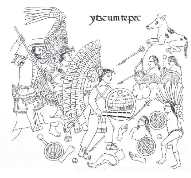 Page from the Lienzo de Tlaxcala depicting the conquest of Izcuintepeque In the half century preceding the arrival of the Spanish, the Kaqchikel were frequently at war with the Pipil of Izcuintepeque (modern Escuintla).[167] By March 1524 the Kʼiche had been defeated, followed by a Spanish alliance with the Kaqchikel in April of the same year.[101] On 8 May 1524, soon after his arrival in Iximche and immediately following his subsequent conquest of the Tzʼutujil around Lake Atitlán, Pedro de Alvarado continued southwards to the Pacific coastal plain with an army numbering approximately 6,000,[nb 8] where he defeated the Pipil of Panacal or Panacaltepeque (called Panatacat in the Annals of the Kaqchikels) near Izcuintepeque on 9 May.[168] Alvarado described the terrain approaching the town as very difficult, covered with dense vegetation and swampland that made the use of cavalry impossible; instead he sent men with crossbows ahead. The Pipil withdrew their scouts because of the heavy rain, believing that the Spanish and their allies would not be able to reach the town that day. However, Pedro de Alvarado pressed ahead and when the Spanish entered the town the defenders were completely unprepared, with the Pipil warriors indoors sheltering from the torrential rain. In the battle that ensued, the Spanish and their indigenous allies suffered minor losses but the Pipil were able to flee into the forest, sheltered from Spanish pursuit by the weather and the vegetation. Pedro de Alvarado ordered the town to be burnt and sent messengers to the Pipil lords demanding their surrender, otherwise he would lay waste to their lands.[169] According to Alvarado's letter to Cortés, the Pipil came back to the town and submitted to him, accepting the king of Spain as their overlord.[170] The Spanish force camped in the captured town for eight days.[169] A few years later, in 1529, Pedro de Alvarado was accused of using excessive brutality in his conquest of Izcuintepeque, amongst other atrocities.[171] The Pacific slope of Jutiapa was the scene of a number of battles with the Xinca. In Guazacapán, now a municipality in Santa Rosa, Pedro de Alvarado described his encounter with people who were neither Maya nor Pipil, speaking a different language altogether; these people were probably Xinca.[44] At this point Alvarado's force consisted of 250 Spanish infantry accompanied by 6,000 indigenous allies, mostly Kaqchikel and Cholutec.[172] Alvarado and his army defeated and occupied the most important Xinca city, named as Atiquipaque, usually considered to be in the Taxisco area. The defending warriors were described by Alvarado as engaging in fierce hand-to-hand combat using spears, stakes and poisoned arrows. The battle took place on 26 May 1524 and resulted in a significant reduction of the Xinca population.[44] Alvarado's army continued eastwards from Atiquipaque, seizing several more Xinca cities. Tacuilula feigned a peaceful reception only to unsuccessfully raise arms against the conquistadors within an hour of their arrival. Taxisco and Nancintla fell soon afterwards. Because Alvarado and his allies could not understand the Xinca language, Alvarado took extra precautions on the march eastward by strengthening his vanguard and rearguard with ten cavalry apiece. In spite of these precautions the baggage train was ambushed by a Xinca army soon after leaving Taxisco. Many indigenous allies were killed and most of the baggage was lost, including all the crossbows and ironwork for the horses.[173] This was a serious setback and Alvarado camped his army in Nancintla for eight days, during which time he sent two expeditions against the attacking army.[174] Jorge de Alvarado led the first attempt with thirty to forty cavalry and although they routed the enemy they were unable to retrieve any of the lost baggage, much of which had been destroyed by the Xinca for use as trophies. Pedro de Portocarrero led the second attempt with a large infantry detachment but was unable to engage with the enemy due to the difficult Kʼicheʼ kingdom of Qʼumarkaj terrain, so returned to Nancintla. Alvarado sent out Xinca messengers to make contact with the enemy but they failed to return. Messengers from the city of Pazaco, in the modern department of Jutiapa,[175] offered peace to the conquistadors but when Alvarado arrived there the next day the inhabitants were preparing for war. Alvarado's troops encountered a sizeable quantity of gathered warriors and quickly routed them through the city's streets. From Pazaco Alvarado crossed the Río Paz and entered what is now El Salvador.[176] After the conquest of the Pacific plain, the inhabitants paid tribute to the Spanish in the form of valuable products such as cacao, cotton, salt and vanilla, with an emphasis on cacao.[177] |
太平洋低地: ピピル族とシンカ族 スペイン人が到着する前、太平洋平野の西側はキチェ族とカクチケル族が支配し、東側はピピル族とシンカ族が占めていた[164]。ピピル族は、現在のエス クィントラ県とフティアパ県の一部に居住していた[165]。シンカ族の主な居住地は、現在のサンタ・ロサ県にあるピピル族の主な居住地の東側にあった [166]。現在のサンタ・ロサ県にあるピピルの主要居住地の東側にあった[166]。また、ジュティアパにもシンカ族がいた[142]。 イスクインテペケの征服を描いた「トラスカラ図」のページ スペイン人が到着するまでの半世紀の間、カクチケル族はイスクインテペケ(現在のエスクイントラ)のピピル族と頻繁に戦争をしていた[167]。1524 年3月までに 1524年3月までにキチェ族は敗北し、同年4月にはスペインとカクチケル族が同盟を結んだ[101]。1524年5月8日、イシムチェに到着し、アティ トラン湖周辺のツトゥヒル族を征服した直後、ペドロ・デ・アルバラドはおよそ6,000人の軍勢を率いてさらに南下し、太平洋沿岸の平原へと進軍した [nb 8]。 [nb 8] 5月9日、イスキンテペケ近郊でパナカルまたはパナカルテペケのピピル族(カクチケル年代記ではパナタカットと呼ばれている)を撃破した[168]。アル ヴァラドは、町に近づく地形が非常に険しく、鬱蒼とした植物と湿地帯に覆われて騎兵隊の進軍が不可能だと述べ、代わりにクロスボウを持った兵士を先陣に 送った。ピピル族は激しい雨のために斥候を撤退させ、スペイン人とその同盟軍は当日町に到着できないだろうと考えた。しかし、ペドロ・デ・アルバラドは前 進を止めず、スペイン軍が町に入ったとき、守備隊はまったく準備ができておらず、ピピル族の戦士たちは激しい雨から逃れるために屋内に避難していた。戦闘 の結果、スペイン人と先住民同盟軍は軽微な損失を被ったが、ピピル族は天候と植生に守られ、スペイン軍の追撃をかわして森に逃げ込むことができた。ペド ロ・デ・アルバラドは町を焼き払い、ピピルの領主たちに降伏を要求する使者を送った。さもなければ領地が荒廃すると脅した[169]。コルテス宛てのアル バラドの手紙によると、ピピル族は町に戻り、スペイン国王を彼らの支配者として受け入れ、彼に服従した[170]。スペイン軍は、占領した町に8日間野営 した[169]。その数年後の1529年、ペドロ・デ・アルバラドは、イズクインテペケ征服において残虐行為を行ったとして、その他の残虐行為とともに告 発された[171]。 フティアパの太平洋側の斜面は、シンカ族との戦いの舞台となった。 グアサカパン(現在のサンタ・ロサ市)で、ペドロ・デ・アルバラドはマヤ族でもピピル族でもない、まったく異なる言語を話す人々との出会いについて述べて いる。おそらく、これらの人々はシンカ族だったのだろう[44]。この時点で、アルバラドの軍勢は25 0人のスペイン人歩兵と、主にカクチケル族とチョルテック族からなる6,000人の先住民同盟軍で構成されていた[172]。アルヴァラドとその軍は、タ クシスコ地域にあると考えられている、最も重要なシンカ族の都市、アティキパケを制圧し占領した。アルヴァラドは、守備隊が槍や杭、毒矢を使った激しい白 兵戦を展開したと述べている。この戦闘は1524年5月26日に起こり、シンカ族の人口を大幅に減らす結果となった[44]。アルヴァラドの軍隊は、ア ティキパケからさらに東に進軍し、いくつかのシンカ族の都市を占領した。タクイラは平和的な歓迎を装ったが、到着から1時間もしないうちにコンキスタドー ルに対して武器を取ることはできなかった。タクスコとナンシントラはその後すぐに陥落した。アルヴァラドと彼の同盟者はシンカ語を理解できなかったため、 アルヴァラドは東進する部隊の前衛と後衛にそれぞれ10人の騎兵を配置し、特別に警戒した。これらの警戒にもかかわらず、タクスコを出発して間もなく、荷 物運搬隊はシンカ軍に待ち伏せされた。多くの先住民同盟者が殺され、ほとんどの荷物が失われた。これには、クロスボウや馬用の鉄製品など、すべての馬具が 含まれていた[173]。これは深刻な挫折であり、アルヴァラドはナンシントラに軍を8日間野営させ、その間に2回の [174] ホルヘ・デ・アルバラドは30~40人の騎兵を率いて最初の攻撃を指揮したが、敵を撃退したものの、失われた荷物の回収には至らなかった。その多くは、戦 利品としてシンカ族によって破壊されていた。ペドロ・デ・ポルトカレーロは、大規模な歩兵部隊を率いて2度目の攻撃を指揮したが、キチェ族の王国クマルカ ハの険しい地形のために敵と交戦することができず、ナンシントラに戻った。アルヴァラドは、敵と接触するためにシンカ族の使者を派遣したが、彼らは戻って くることができなかった。ユティアパ県パサコ市[175]からの使者は征服者たちに和平を申し出たが、翌日アルヴァラドが到着した時には住民たちは戦争の 準備をしていた。アルヴァラドの部隊は、かなりの数の戦士が集まっているのを見つけ、すぐに街の通りで彼らを追い散らした。パサコからアルヴァラドはリ オ・パス川を渡り、現在のエルサルバドルに入った[176]。 太平洋平野の征服後、住民たちはスペイン人に対して、カカオ、綿、塩、バニラといった貴重な産物を貢納した。特にカカオが重視された[177]。 |
| Northern lowlands The Contact Period in Guatemala's northern Petén lowlands lasted from 1525 through to 1700.[178] Superior Spanish weaponry and the use of cavalry, although decisive in the northern Yucatán, were ill-suited to warfare in the dense forests of lowland Guatemala.[179] Cortés in Petén 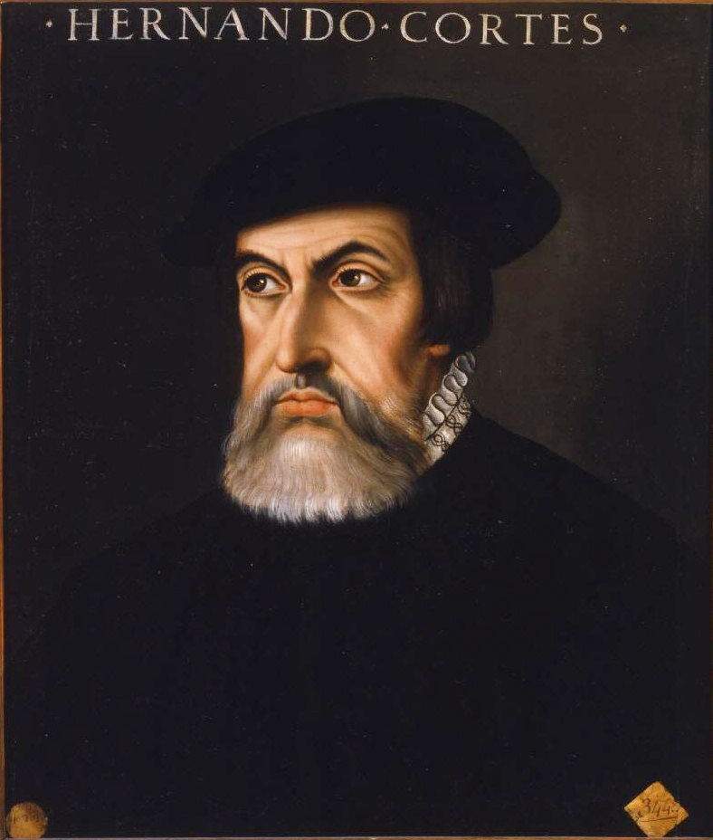 Painting of Hernán Cortés Hernán Cortés, conqueror of the Aztecs, travelled across Petén in the early 16th century. In 1525, after the Spanish conquest of the Aztec Empire, Hernán Cortés led an expedition to Honduras over land, cutting across the Itza kingdom in what is now the northern Petén Department of Guatemala.[180] His aim was to subdue the rebellious Cristóbal de Olid, whom he had sent to conquer Honduras, but Cristóbal de Olid had set himself up independently on his arrival in that territory.[181] Cortés had 140 Spanish soldiers, 93 of them mounted, 3,000 Mexican warriors, 150 horses, a herd of pigs, artillery, munitions and other supplies. He also had with him 600 Chontal Maya carriers from Acalan. They arrived at the north shore of Lake Petén Itzá on 13 March 1525.[182] Cortés accepted an invitation from Aj Kan Ekʼ, the king of the Itza, to visit Nojpetén (also known as Tayasal), and crossed to the Maya city with 20 Spanish soldiers while the rest of his army continued around the lake to meet him on the south shore.[183] On his departure from Nojpetén, Cortés left behind a cross and a lame horse. The Spanish did not officially contact the Itza again until the arrival of Franciscan priests in 1618, when Cortés' cross was said to still be standing at Nojpetén.[180] From the lake, Cortés continued south along the western slopes of the Maya Mountains, a particularly arduous journey that took 12 days to cover 32 kilometres (20 mi), during which he lost more than two-thirds of his horses. When he came to a river swollen with the constant torrential rains that had been falling during the expedition, Cortés turned upstream to the Gracias a Dios rapids, which took two days to cross and cost him more horses.[184] On 15 April 1525 the expedition arrived at the Maya village of Tenciz. With local guides they headed into the hills north of Lake Izabal, where their guides abandoned them to their fate. The expedition became lost in the hills and came close to starvation before they captured a Maya boy who led them out to safety.[184] Cortés found a village on the shore of Lake Izabal, perhaps Xocolo. He crossed the Dulce River to the settlement of Nito, somewhere on the Amatique Bay,[185] with about a dozen companions, and waited there for the rest of his army to regroup over the course of the next week.[184] By this time the remnants of the expedition had been reduced to a few hundred; Cortés succeeded in contacting the Spaniards he was searching for, only to find that Cristóbal de Olid's own officers had already put down his rebellion.[186] Cortés constructed an improvised brigantine and, accompanied by canoes, he ascended the Dulce River to Lake Izabal, with about 40 Spaniards, and a number of Indians. He at first believed he had reached the Pacific, but soon realised his error. At the western end of the lake, he marched inland and engaged in battle with the Maya natives at the city of Chacujal,[187] on the Polochic River.[188] He seized plentiful supplies of food from the city and sent supplies back to Nito in the brigantine. He had rafts built to ferry supplies back downriver, and returned to Nito with them, while most of his men marched back overland.[189] Cortés then returned to Mexico by sea.[186] Land of War: Verapaz Painting of Bartolomé de las Casas Dominican friar Bartolomé de las Casas promoted the peaceful conversion of the native peoples. By 1537 the area immediately north of the new colony of Guatemala was being referred to as the Tierra de Guerra ("Land of War").[190][nb 9] Paradoxically, it was simultaneously known as Verapaz ("True Peace").[191] The Land of War described an area that was undergoing conquest; it was a region of dense forest that was difficult for the Spanish to penetrate militarily. Whenever the Spanish located a centre of population in this region, the inhabitants were moved and concentrated in a new colonial settlement near the edge of the jungle where the Spanish could more easily control them. This strategy resulted in the gradual depopulation of the forest, simultaneously converting it into a wilderness refuge for those fleeing Spanish domination, both for individual refugees and for entire communities, especially those congregaciones that were remote from centres of colonial authority.[192] The Land of War, from the 16th century through to the start of the 18th century, included a vast area from Sacapulas in the west to Nito on the Caribbean coast and extended northwards from Rabinal and Salamá,[193] and was an intermediate area between the highlands and the northern lowlands.[194] It includes the modern departments of Baja Verapaz and Alta Verapaz, Izabal and Petén, as well as the eastern part of El Quiché and a part of the Mexican state of Chiapas.[195] The western portion of this area was the territory of the Qʼeqchiʼ Maya.[196] Pedro Orozco,[nb 10] the leader of the Sacatepéquez Mam of San Marcos department, lent willing help to the Dominicans in their campaign to peacefully subject the inhabitants of Verapaz. On 1 May 1543 Carlos V rewarded the Sacatepéquez Mam by issuing a royal order promising never to give them in encomienda.[197] Dominican friar Bartolomé de las Casas arrived in the colony of Guatemala in 1537 and immediately campaigned to replace violent military conquest with peaceful missionary work.[198] Las Casas offered to achieve the conquest of the Land of War through the preaching of the Catholic faith.[199] It was the Dominicans who promoted the use of the name Verapaz instead of the Land of War.[191] Because it had not been possible to conquer the land by military means, the governor of Guatemala, Alonso de Maldonado, agreed to sign a contract promising he would not establish any new encomiendas in the area should Las Casas' strategy succeed. Las Casas and a group of Dominican friars established themselves in Rabinal, Sacapulas and Cobán, and managed to convert several native chiefs using a strategy of teaching Christian songs to merchant Indian Christians who then ventured into the area. one could make a whole book ... out of the atrocities, barbarities, murders, clearances, ravages and other foul injustices perpetrated ... by those that went to Guatemala 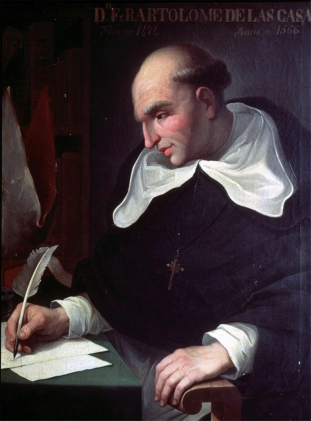 Bartolomé de las Casas[200] In this way they congregated a group of Christian Indians in the location of what is now the town of Rabinal.[201] Las Casas became instrumental in the introduction of the New Laws in 1542, established by the Spanish Crown to control the excesses of the conquistadors and colonists against the indigenous inhabitants of the Americas.[190] As a result, the Dominicans met substantial resistance from the Spanish colonists, who saw their own interests threatened by the New Laws; this distracted the Dominicans from their efforts to establish peaceful control over the Land of War.[191] In 1543 the new colonial reducción of Santo Domingo de Cobán was founded at Chi Monʼa to house the relocated Qʼeqchiʼ from Chichen, Xucaneb and Al Run Tax Aj. Santo Tomás Apóstol was founded nearby the same year at Chi Nim Xol, it was used in 1560 as a reducción to resettle Chʼol communities from Topiltepeque and Lacandon in the Usumacinta Valley.[202] In 1555 the Acala Chʼol and their Lacandon allies killed the Spanish friar Domingo de Vico.[203] De Vico had established a small church among the inhabitants of San Marcos,[204] a region that lay between the territories of the Lacandon and the Manche Chʼol (an area unrelated to the department of San Marcos).[205] De Vico had offended the local ruler by repeatedly scolding him for taking several wives.[204] The indigenous leader shot the friar through the throat with an arrow; the angry natives then seized him, cut open his chest and extracted his heart.[206] His corpse was then decapitated;[206] the natives carried off his head, which was never recovered by the Spanish.[207] In response a punitive expedition was launched, headed by Juan Matalbatz, a Qʼeqchiʼ leader from Chamelco; the independent Indians captured by the Qʼeqchiʼ expedition were taken back to Cobán and resettled in Santo Tomás Apóstol.[208] Lake Izabal and the lower Motagua River Gil González Dávila set out from the Caribbean island of Hispaniola early in 1524,[209] with the intention of exploring the Caribbean coast of Nicaragua. His course took him to the north coast of Honduras.[210] After founding Puerto de Caballos, Gil Gónzalez sailed west along the coast to the Amatique Bay, and founded a Spanish settlement somewhere near the Dulce River, within modern-day Guatemala, which he named San Gil de Buena Vista.[210] He launched a campaign of conquest in the mountainous region dividing Honduras from Guatemala.[211] González left some of his men under the command of Francisco Riquelme at San Gil de Buena Vista,[212] and sailed back east along the coast to Honduras. The colonists at San Gil did not prosper, and soon set out in search of a more hospitable location. They resettled in the important indigenous town of Nito, near the mouth of the Dulce River.[210] Although they were in a desperate state, and near-starving, they were still there when Hernan Cortés passed through en route to Honduras, and were absorbed into his expedition.[187] The Dominicans established themselves in Xocolo on the shore of Lake Izabal in the mid-16th century. Xocolo became infamous among the Dominican missionaries for the practice of witchcraft by its inhabitants. By 1574 it was the most important staging post for European expeditions into the interior, and it remained important in that role until as late as 1630, although it was abandoned in 1631.[213] In 1598 Alfonso Criado de Castilla became governor of the Captaincy General of Guatemala. Owing to the poor state of Puerto de Caballos on the Honduran coast and its exposure to repeated pirate raids he sent a pilot to scout Lake Izabal.[213] As a result of the survey, and after royal permission was granted, Criado de Castilla ordered the construction of a new port, named Santo Tomás de Castilla, at a favourable spot on the Amatique Bay not far from the lake. Work then began on building a highway from the port to the new capital of the colony, modern Antigua Guatemala, following the Motagua Valley into the highlands. Indigenous guides scouting the route from the highlands would not proceed further downriver than three leagues below Quiriguá, because the area was inhabited by the hostile Toquegua.[214] The Castillo de San Felipe was a Spanish fort that guarded the entrance to Lake Izabal. The leaders of Xocolo and Amatique, backed by the threat of Spanish action, persuaded a community of 190 Toquegua to settle on the Amatique coast in April 1604. The new settlement immediately suffered a drop in population, but although the Amatique Toquegua were reported extinct before 1613 in some sources, Mercedarian friars were still attending to them in 1625.[215] In 1628 the towns of the Manche Chʼol were placed under the administration of the governor of Verapaz, with Francisco Morán as their ecclesiastical head. Morán favoured a more robust approach to the conversion of the Manche and moved Spanish soldiers into the region to protect against raids from the Itza to the north. The new Spanish garrison in an area that had not previously seen a heavy Spanish military presence provoked the Manche to revolt, which was followed by abandonment of the indigenous settlements.[216] By 1699 the neighbouring Toquegua no longer existed as a separate people because of a combination of high mortality and intermarriage with the Amatique Indians.[215] At around this time the Spanish decided on the reduction of the independent (or "wild" from the Spanish point of view) Mopan Maya living to the north of Lake Izabal.[217] The north shore of the lake, although fertile, was by then largely depopulated, therefore the Spanish planned to bring the Mopan out of the forests to the north into an area where they could be more easily controlled.[218] During the campaign to conquer the Itza of Petén, the Spanish sent expeditions to harass and relocate the Mopan north of Lake Izabal and the Chʼol Maya of the Amatique forests to the east. They were resettled in the Colonial reducción of San Antonio de las Bodegas on the south shore of the lake and in San Pedro de Amatique. By the latter half of the 18th century, the indigenous population of these towns had disappeared; the local inhabitants now consisted entirely of Spaniards, mulattos and others of mixed race, all associated with the Castillo de San Felipe de Lara fort guarding the entrance to Lake Izabal.[218] The main cause of the drastic depopulation of Lake Izabal and the Motagua Delta was the constant slave raids by the Miskito Sambu of the Caribbean coast that effectively ended the Maya population of the region; the captured Maya were sold into slavery, a practise which was widespread among the Miskito.[219] Conquest of Petén Main article: Spanish conquest of Petén Northern Guatemala is a flat lowland plain dropping off from the Cuchumatanes mountain range sweeping across in an arc to the south. To the east of the mountains is the large lowland Lake Izabal, with an outlet into the Amatique Bay to the east, which itself opens onto the Gulf of Honduras. Immediately north of the mountains is the Lacandon forest, with Petén to the northeast. Ystapalapán was a settlement in the western Cuchumatanes, in the territory of the Chuj. Cobán was in Qʼeqchiʼ territory, in the foothills halfway between Ystapalapán in the west and Lake Izabal in the east. Xocolo was at the northeastern extreme of Lake Izabal, where it flows out towards the sea. Nito, also known as Amatique, was on the coast where the river flowing out of the lake opened into the Amatique Bay. The area south of the lake was Toquegua territory. The Manche occupied the lands to the northwest of the lake, with the Acala to their west between the Manche and the Chuj. The Lacandon were northwest of the Acala, straddling the border with Mexico. Lake Petén Itzá was in the centre of Petén, to the north. It was the location of Nojpetén, with the Itza lands stretching southwards from the lake. To the east of the Itza and northeast of the Manche were the Mopan, on the border with Belize. North of the Mopan were the Yalain, east of Lake Petén Itzá. The Kowoj were to the northeast of the lake and the Kejache to the northwest. The "Tierra de Guerra" ("Land of War") covers a broad northern swathe of the mountains and the southern portion of the lowlands. 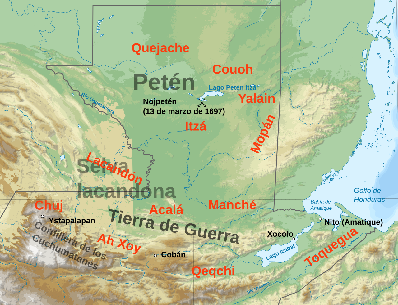 Map of the northern Guatemalan lowlands at the time of Spanish contact From 1527 onwards the Spanish were increasingly active in the Yucatán Peninsula, establishing a number of colonies and towns by 1544, Xocolo Campeche and Valladolid in what is now Mexico.[220] The Spanish impact on the northern Maya, encompassing invasion, epidemic diseases and the export of up to 50,000 Maya slaves, caused many Maya to flee southwards to join the Itza around Lake Petén Itzá, within the modern borders of Guatemala.[221] The Spanish were aware that the Itza Maya had become the centre of anti-Spanish resistance and engaged in a policy of encircling their kingdom and cutting their trade routes over the course of almost two hundred years. The Itza resisted this steady encroachment by recruiting their neighbours as allies against the slow Spanish advance.[179] Dominican missionaries were active in Verapaz and the southern Petén from the late 16th century through the 17th century, attempting non-violent conversion with limited success. In the 17th century the Franciscans came to the conclusion that the pacification and Christian conversion of the Maya would not be possible as long as the Itza held out at Lake Petén Itzá. The constant flow of escapees fleeing the Spanish-held territories to find refuge with the Itza was a drain on the encomiendas.[179] Fray Bartolomé de Fuensalida visited Nojpetén in 1618 and 1619.[222] The Franciscan missionaries attempted to use their own reinterpretation of the kʼatun prophecies when they visited Nojpetén at this time, to convince the current Aj Kan Ekʼ and his Maya priesthood that the time for conversion had come.[223] But the Itza priesthood interpreted the prophecies differently, and the missionaries were fortunate to escape with their lives. In 1695 the colonial authorities decided to connect the province of Guatemala with Yucatán, and Guatemalan soldiers conquered a number of Chʼol communities, the most important being Sakbʼajlan on the Lacantún River in eastern Chiapas, now in Mexico, which was renamed as Nuestra Señora de Dolores, or Dolores del Lakandon. The Franciscan friar Andrés de Avendaño oversaw a second attempt to overcome the Itza in 1695, convincing the Itza king that the Kʼatun 8 Ajaw, a twenty-year Maya calendrical cycle beginning in 1696 or 1697, was the right time for the Itza to finally embrace Christianity and to accept the king of Spain as overlord. However the Itza had local Maya enemies who resisted this conversion, and in 1696 Avendaño was fortunate to escape with his life. The Itza's continued resistance had become a major embarrassment for the Spanish colonial authorities, and soldiers were despatched from Campeche to take Nojpetén once and for all.[224] Fall of Nojpetén Martín de Ursúa y Arizmendi arrived on the western shore of Lake Petén Itzá with his soldiers on 26 February 1697 and, once there, built a galeota, a large and heavily armed oar-powered attack boat.[225] The Itza capital fell in a bloody waterborne assault on 13 March 1697.[226] The Spanish bombardment caused heavy loss of life on the island; many Itza Maya who fled to swim across the lake were killed in the water.[225] After the battle the surviving defenders melted away into the forests, leaving the Spanish to occupy an abandoned Maya town.[224] The Itza and Kowoj kings (Ajaw Kan Ekʼ and Aj Kowoj) were soon captured, together with other Maya nobles and their families. With Nojpetén safely in the hands of the Spanish, Ursúa returned to Campeche; he left a small garrison on the island, isolated amongst the hostile Itza and Kowoj who still dominated the mainland. Nojpetén was renamed by the Spanish as Nuestra Señora de los Remedios y San Pablo, Laguna del Itza ("Our Lady of Remedy and Saint Paul, Lake of the Itza"). The garrison was reinforced in 1699 by a military expedition from Guatemala, accompanied by mixed-race ladino civilians who came to found their own town around the military camp. The settlers brought disease with them, which killed many soldiers and colonists and swept through the indigenous population. The Guatemalans stayed just three months before returning to Santiago de los Caballeros de Guatemala, taking the captive Itza king with them, together with his son and two of his cousins. The cousins died on the long journey to the colonial capital; Ajaw Kan Ekʼ and his son spent the rest of their lives under house arrest in the capital.[225] Final years of conquest In the late 17th century the small population of Chʼol Maya in southern Petén and Belize was forcibly removed to Alta Verapaz, where the people were absorbed into the Qʼeqchiʼ population. The Chʼol of the Lacandon Jungle were resettled in Huehuetenango in the early 18th century.[227] Catholic priests from Yucatán founded several mission towns around Lake Petén Itzá in 1702–1703. Surviving Itza and Kowoj were resettled in the new colonial towns by a mixture of persuasion and force. Kowoj and Itza leaders in these mission towns rebelled against their Spanish overlords in 1704, but although well-planned, the rebellion was quickly crushed. Its leaders were executed and most of the mission towns were abandoned. By 1708 only about 6,000 Maya remained in central Petén, compared to ten times that number in 1697.[225] Although disease was responsible for the majority of deaths, Spanish expeditions and internecine warfare between indigenous groups also played their part.[228] |
北部低地 グアテマラ北部のペテン低地における接触期は、1525年から1700年まで続いた[178]。スペインの優れた武器と騎兵隊の使用は、ユカタン半島北部では決定的だったが、 グアテマラ低地の密林での戦闘には不向きだった[179]。 ペテンにおけるコルテス エルナン・コルテスの絵画 アステカ帝国を征服したエルナン・コルテスは、16世紀初頭にペテンを横断した。 1525年、スペインによるアステカ帝国の征服後、エルナン・コルテスは陸路でホンジュラス遠征隊を率い、現在のグアテマラ北部ペテン県にあたるイツァ王 国を横断した[180]。彼の目的は、ホンジュラス征服のために派遣した反逆者クリストバル・デ・オリドを服従させることだった。しかし、クリストバル・ デ・オリドはホンジュラスに到着すると、独立を宣言していた[181]。コルテスは、スペイン兵140人(うち騎馬兵93人)、メキシコ人戦士3,000 人、馬150頭、豚の群れ、大砲、弾薬、その他の物資を携えていた。また、アカランのチョルタル・マヤ族の運搬人600人も同行していた。彼らは1525 年3月13日にペテン・イッツァ湖の北岸に到着した[182]。 コルテスはイツァ族の王アジャ・カン・エクの招待を受け入れ、ノペテン(別名タイ・アサル)を訪れた。 、20人のスペイン人兵士を連れてマヤの都市へと渡った。残りの軍勢は湖の周囲を回って南岸で合流することになっていた[183]。コルテスがノペテンを 出発する際、十字架と足の悪い馬を残していった。スペイン人が再びイツァ族と公式に接触したのは、1618年にフランシスコ会の修道士たちが到着した時で あり、その時にはコルテスの十字架がまだノペテンの地に立っていたと言われている[180]。湖からコルテスはマヤ山脈の西斜面を南に向かって進み、特に 過酷な旅を続けた。32キロメートルを12日間かけて移動し、その間に馬の3分の2以上を失った。探検中絶え間なく降り続いた豪雨で川が増水していたた め、コルテスは上流のグラシアス・ア・ディオス(Gracias a Dios)の急流に向かった。 1525年4月15日、探検隊はマヤのテンシズ村に到着した。現地の案内人の案内でイサバル湖の北にある丘に向かったが、案内人は彼らを見捨てて立ち去っ た。探検隊は丘の中で迷子になり、飢餓寸前に陥ったが、マヤ人の少年を捕まえて無事に脱出することができた[184]。コルテスはイサバル湖のほとりにあ る村、おそらくソコロを見つけた。彼は、約12人の仲間とともに、ドルセ川を渡り、アマティク湾のどこかにあるニトの集落に向かった[185]。そこで、 翌週にかけて残りの軍隊が再編成されるのを待った[184]。この時点で、遠征の生き残りは数百人にまで減っていたが、コルテスは 探していたスペイン人と連絡を取ることができたが、クリストバル・デ・オリドの部下たちがすでに彼の反乱を鎮圧していたことがわかった[186]。コルテ スは即席のブリガンティン船を建造し、カヌーを伴って、約40人のスペイン人と多数のインディアンを連れて、ドルセ川を遡り、イサバル湖まで上った。彼は 最初、太平洋に到達したと思ったが、すぐに間違いに気づいた。湖の西端で彼は内陸に進軍し、ポロチク川沿いのチャクハル市[187]でマヤ先住民と交戦し た[188]。彼はこの都市から豊富な食糧を手に入れ、ブリガンティンでニトに物資を送り返した。彼は物資を下流に運ぶためのいかだを建造し、それを使っ てニトに戻った。一方、彼の部下の大半は陸路で戻った[189]。コルテスはその後、海路でメキシコに戻った[186]。 戦争の地:ベラパス バルトロメ・デ・ラス・カサスを描いた絵画 ドミニコ会の修道士バルトロメ・デ・ラス・カサスは、先住民を平和的に改宗させることを推進した。 1537年までに、グアテマラの新しい植民地のすぐ北の地域は「Tierra de Guerra(戦争の地)」と呼ばれるようになった[190][nb 9]。皮肉なことに、同時に「Verapaz(真の平和)」としても知られていた[191]。戦争の地とは、征服の過程にある地域を指していた。そこはス ペイン軍が軍事的に侵入するのが困難な密林地帯であった。スペインがこの地域に人口の中心地を見つけたときはいつでも、住民は移動させられ、スペイン人が より容易に彼らを統制できるジャングルの端近くの新しい植民地集落に集められた。この戦略により、森林は徐々に過疎化していった。同時に、スペインの支配 から逃れる人々にとって、森林は荒野の避難場所となった。特に、植民地当局の中心地から離れた集落と、個々の難民の両方にとってそうであった[192]。 16世紀から18世紀初頭にかけての「戦争の地」は、西はサカプラスからカリブ海沿岸のニトまで、北は ラビナルとサラマから北に延びており[193]、高地と北部低地の中間地域であった[194]。この地域には、現在のバハ・ベラパス県、アルタ・ベラパス 県、イサバル県、ペテン県、エル・キチェ東部、メキシコのチアパス州の一部[195]が含まれる。この地域の西部はケクチ・マヤ族の領土であった [196]。 サン・マルコス県のサカテペケス・マムの指導者ペドロ・オロスコ[注釈 10]は、ベラパス住民を平和的に服従させるドミニカ人の運動に快く協力した。1543年5月1日、カルロス5世はサカテペケス族にエンコミエンダを与え ないことを約束する勅令を発布し、彼らに報いた[197]。 ドミニコ会の修道士バルトロメ・デ・ラス・カサス(Bartolomé de las Casas)は1537年にグアテマラ植民地に到着し、すぐに暴力的な軍事征服を平和的な布教活動に置き換える運動を開始した[198]。ラス・カサス は、 戦争の土地」の征服をカトリックの布教によって成し遂げると申し出たのだ[199]。戦争の土地」の代わりにベラパスという名称の使用を推進したのはドミ ニコ会だった[191]。軍事的手段で土地を征服することは不可能だったため、グアテマラ総督のアルフォンソ・デ・マルドナドは、ラス・カサスの戦略が成 功した場合、その地域には新たなエンコミエンダを設置しないと約束する契約に署名することに同意した。ラス・カサスとドミニコ会の修道士たちは、ラビナ ル、サカプラス、コバンに拠点を置き、その地域に進出したインディオのキリスト教徒商人たちにキリスト教の歌を教えるという戦略を用いて、何人かの先住民 の酋長たちを改宗させることに成功した。 グアテマラに行った者たちが犯した残虐行為、野蛮さ、殺人、虐殺、破壊、その他のひどい不正義について、 バルトロメ・デ・ラス・カサス [200] こうして彼らは、現在のラビナルという町の場所にキリスト教徒のインディアンを集めた。[201] 1542年、スペイン王室がアメリカ先住民に対する征服者や入植者の行き過ぎを抑制するために制定した新法導入において、ラス・カサスが決定的な役割を果 たした。[190] その結果、ドミニコ会は 新法によって自分たちの利益が脅かされると考えるスペイン人入植者たちから大きな抵抗に遭い、その結果、ドミニコ会は「戦争の地」に平和的な支配を確立す るという努力から目をそらさざるを得なくなった[191]。 1543年、チモンアにサン・ドミンゴ・デ・コバンの新しい植民地レドゥシオンが設立され、チチェン、シュカネブ、アル・ラン・タックス・アジュから移住 してきたケクチ族が収容された。同じ年にチ・ニム・ソルにサン・トマス・アポストルが設立され、1560年にはウスマシンタ渓谷のトピルテペケとラカンド ンから移住してきたチョル族のコミュニティを再定住させるためのレドゥクションとして使用された[202]。1555年、アカラ・チョル族とラカンドン族 の同盟軍がスペイン人修道士ドミンゴ・デ・ビコを殺害した[ 203] デ・ビコはサン・マルコス住民の間に小さな教会を設立していた。サン・マルコスは、ラカンドン族とマンチェ・チョール族(サン・マルコス県とは無関係な地 域)の領土の間に位置する地域である[205]。デ・ビコは、複数の妻を持つことを理由に地元の支配者を繰り返し叱責し、怒らせていた[204]。先住民 の指導者は、矢で修道士を喉から射殺した。 先住民の長は矢で彼の喉を射抜き、怒った先住民たちは彼を捕らえ、胸を切り裂き、心臓を取り出した[206]。その後、彼の死体は首を切られた [206]。先住民たちは彼の首を持ち去ったが、スペイン軍はそれを回収することはできなかった[207]。これを受けて、チャメルコ出身のケクチ族の指 導者フアン・マタバルツが率いる懲罰遠征隊が結成された 。Qʼeqchiʼ遠征隊に捕らえられたインディアンたちはコバンに連れ戻され、サント・トマス・アポストルに再定住させられた[208]。 イサバル湖とモタグア川下流域 ギル・ゴンサレス・ダビラは、1524年初頭にカリブ海のイスパニョーラ島を出発し、ニカラグアのカリブ海沿岸を探検するつもりだった[209]。彼の航 路はホンジュラスの北岸へと導いた[210]。プエルト・デ・カバロスを建設した後、ギル・ゴンザレスは海岸沿いを西に航行しアマティク湾に到着し、現在 のグアテマラにあるドルセ川付近にスペイン人入植地を建設し、サン・ギル・デ・ブエナ・ビスタと名付けた[210]。ブエナ・ビスタと名付けた [210]。彼はホンジュラスとグアテマラを隔てる山岳地帯の征服に乗り出した[211]。ゴンザレスは部下の一部をサン・ギル・デ・ブエナ・ビスタに残 し、フランシスコ・リケルメに指揮を任せた[212]。そして、海岸沿いに東へ戻ってホンジュラスに戻った。サンギルの入植者たちは成功を収めることはで きず、すぐにより住みやすい場所を探しに出かけた。彼らは、ドルセ川の河口付近にある先住民の重要な町ニトに移住した[210]。彼らは絶望的な状態にあ り、餓死寸前であったが、エルナン・コルテスがホンジュラスに向かう途中、そこを通りかかった際にまだそこにいたため、彼の探検隊に吸収された [187]。 ドミニコ会は、16世紀半ばにイサバル湖の湖畔にあるショコロに定住した。Xocoloは住民による魔術の儀式で、ドミニカ人宣教師の間では悪名高い場所 となった。1574年までに、ヨーロッパからの内陸部探検隊にとって最も重要な中継地となり、1631年に放棄されるまで、その役割を1630年頃まで担 い続けた。 1598年、アルフォンソ・クリアード・デ・カスティージャがグアテマラ総督に就任した。ホンジュラス沿岸のプエルト・デ・カバジョスの状態が良くなく、 度重なる海賊の襲撃にさらされていたため、彼はパイロットを派遣してイサバル湖を偵察させた[213]。調査の結果、王室の許可が下りた後、クリアド・ デ・カスティージャは、湖からほど近いアマティク湾の好立地に、サント・トマス・デ・カスティージャと名付けられた新しい港の建設を命じた。その後、植民 地の新しい首都である近代的なアンティグア・グアテマラまで、モタグア渓谷に沿って高地へと続く港から幹線道路の建設工事が始まった。高地からルートを偵 察していた先住民のガイドたちは、その地域が敵対的なトケグア族の居住地であったため、キリグアから3リーグ(約5.6km)以上川を下ることはなかった [214]。 サン・フェリペ城は、イサバル湖の入り口を警備するスペインの砦であった。 スペインの行動の脅威に後押しされたショコロとアマティークの指導者たちは、1604年4月に190人のトケグア族のコミュニティをアマティーク海岸に移 住させることに成功した。新しい入植地はすぐに人口減少に見舞われたが、1613年以前にアマティク・トケグア族が絶滅したと報告されている情報源もある が、1625年にはメルセダ修道会の修道士がまだ彼らの世話をしていた[215]。1628年、マンチェ・チョルの町はベラパスの知事の管轄下に置かれ、 フランシスコ・モランが彼らの宗教的指導者となった。モランはマンチェ族の改宗に強硬なアプローチを採り、北部のイツァ族からの襲撃に備えてスペイン兵を この地域に移動させた。それまでスペイン軍の駐留が少なかった地域に新たにスペイン軍が駐留したことは、マンチェ族の反乱を招き、先住民族の集落が放棄さ れる結果となった[216]。1699年までに、隣接するトケグア族は、高い死亡率とアマティク族インディアンとの通婚により、もはや独立した民族として 存在しなくなった[215]。 [215] スペイン人はこの頃に、イサバル湖の北側に住む独立した(スペイン人から見て「野蛮な」)モパン・マヤの人口削減を決定した[217]。湖の北岸は肥沃で はあるが、当時すでに人口が大幅に減少していたため、スペイン人は 北の森からモパン族を連れ出し、より容易に管理できる地域に移住させる計画を立てた[218]。 ペテンのイツァ族征服作戦中、スペイン人はイサバル湖の北に住むモパン族と、東のアマティク森林に住むチョル・マヤ族を悩ませ、移住させる遠征隊を送っ た。彼らは、湖の南岸にある植民地時代のサン・アントニオ・デ・ラス・ボデガスとサン・ペドロ・デ・アマティークに移住させられた。18世紀後半までに、 これらの町の先住民は姿を消し、地元住民はスペイン人と混血、その他混血の人種のみで構成されるようになった。彼らは皆、イサバル湖の入り口を警備するサ ン・フェリペ・デ・ララ城と関係があった[218]。イサバル湖とモタグアデルタの急激な人口減少の主な原因は、カリブ海沿岸のミスキート・サンブ族によ る奴隷狩りであった。この奴隷狩りは、この地域のマヤ族を事実上絶滅させた。捕らえられたマヤ族は奴隷として売られ、この慣習はミスキート族の間で広く行 われていた[219]。 ペテンの征服 メイン記事: ペテンのスペインによる征服 グアテマラ北部は、クチュマタン山脈から南に向かって弧を描くように広がる平坦な低地である。山脈の東側には、東にアマティク湾に注ぐ大きな低地であるイ サバル湖があり、その湾はホンジュラス湾に面している。山脈のすぐ北側にはラカンドン森林があり、北東にはペテンがある。イスパラパンは、クチュマタン山 脈西部のチュ族の居住地であった。コバンはケクチ族の居住地で、イスパラパン西とイサバル湖東の中間に位置する丘陵地帯にあった。ソコロはイサバル湖の北 東端にあり、湖から海に向かって流れ出る場所であった。ニト(別名アマティーク)は、湖から流れ出る川がアマティーク湾に注ぐ海岸に位置していた。湖の南 側はトケグア族の領土であった。マンチェ族は湖の北西側の土地を占領し、その西にはアカラ族がマンチェ族とチュウ族の間に位置していた。ラカンドン族はア カラ族の北西に位置し、メキシコとの国境にまたがっていた。ペテン・イッツァ湖はペテンの中心部にあり、北に位置していた。湖の南側にはイツァ族の土地が 広がり、その場所にノプテンの集落があった。イツァ族の東、マンチェ族の北東にはベリーズとの国境に接するモパン族が住んでいた。モパン族の北にはペテ ン・イッツァ湖の東にヤライン族が住んでいた。湖の北東にはコウォフ族、北西にはケジャチェ族が住んでいた。 「ティエラ・デ・ゲラ」(「戦争の地」)は、山脈の北側広範囲と低地の南側一帯をカバーしている。 スペイン人が接触した当時のグアテマラ北部低地の地図 1527年以降、スペイン人はユカタン半島でますます活発に活動し、1544年までに現在のメキシコにあるXocolo CampecheとValladolidに多くの植民地と町を設立した[220]。スペインによる侵略、疫病、最大5,000人のマヤ奴隷の輸出を含む北 部マヤに対するスペインの影響により、多くのマヤ人がペテン・イッツァ湖周辺のイッツァ族に加わるために南に逃れた。 0,000人のマヤ奴隷を輸出するなど、スペインによる北部マヤへの侵略は、多くのマヤをグアテマラの現在の国境内にあるペテン・イッツァ湖周辺のイツァ 族に加わるために南へと逃亡させた[221]。スペイン人は、イツァ・マヤが反スペイン抵抗の中心地となっていることを認識しており、ほぼ200年にわ たって彼らの王国を包囲し、交易路を断つ政策を取った。イツァ族は、スペイン軍の緩慢な前進に対抗するため、近隣住民を味方につけて、この着実な侵略に抵 抗した[179]。 16世紀後半から17世紀にかけて、ドミニコ会の宣教師たちがベラパスとペテンの南部で活動し、非暴力的改宗を試みたが、成功は限定的だった。17世紀、 フランシスコ会は、ペテン・イッツァ湖にイツァ族が抵抗を続ける限り、マヤ族の平和化とキリスト教への改宗は不可能だという結論に達した。スペイン領から 逃れて、イツァ族の保護を求める逃亡者が絶え間なく流入していたため、エンコミエンダは疲弊していた[179]。フラ・バルトロメ・デ・フエンサリダは 1618年と1619年にノペテンを訪れた[222]。フランシスコ会の宣教師たちは、 この時期にノジュペテンを訪れた際、カトゥン予言を独自に解釈し、現在のアジュ・カン・エクとマヤの聖職者たちに改宗の時が来たことを納得させようとした [223]。しかし、イツァの聖職者たちは予言を異なる解釈をし、宣教師たちは命からがら逃げおおせる幸運に恵まれた。1695年、植民地当局はグアテマ ラ州とユカタン半島を結びつけることを決定し、グアテマラ兵は多数のチョル族の集落を征服した。最も重要なのは、現在のメキシコ、チアパス州東部のラカン トゥン川沿いにあるサクバジュランで、ヌエストラ・セニョーラ・デ・ドロレス(Nuestra Señora de Dolores)またはドロレス・デル・ラカンドン(Dolores del Lakandon)と改名された。1695年、フランシスコ会の修道士アンドレス・デ・アベンダニョは、イツァ族を征服する2度目の試みを監督し、イツァ 族の王に、1696年または1697年から始まる20年間のマヤ暦のサイクルであるカトゥン8アジャウが、イツァ族が最終的にキリスト教を受け入れ、スペ イン王を支配者として受け入れるのにふさわしい時期であることを説得した。しかし、イツァ族にはこの改宗に抵抗する地元のマヤ族の敵がおり、1696年、 アベンダニョは命からがら逃げおおせる幸運に恵まれた。イツァ族の抵抗はスペイン植民地当局にとって大きな恥となり、カンペチェからノヘペテンを完全に制 圧するために兵士が派遣された[224]。 ノホペテンの陥落 1697年2月26日、マルティン・デ・ウルスーア・イ・アリスメンドはペテン・イッツァ湖の西岸に兵士たちを率いて到着し、そこで大型で重武装のオール 推進攻撃艇ガレオタを建造した[225]。1697年3月13日、イッツァの首都は水上の血みどろの攻撃で陥落した[226]。 スペイン軍の砲撃により、島では多くの犠牲者が出た。湖を泳いで逃げた多くのイツァ・マヤ族が水中で命を落としたのである[225]。戦闘後、生き残った 守備隊は森の中に姿を消し、スペイン軍は放棄されたマヤの町を占領した[224]。イツァとコウォジの王(アジャ・カン・エクとアジャ・コウォジ)は、他 のマヤの貴族とその家族とともにすぐに捕らえられた。スペイン軍がノジュペテンを制圧すると、ウルスーアはカンペチェに戻った。彼は、まだ本土を支配して いた敵対的なイツァ族とコウォイ族に囲まれたこの島に、小さな守備隊を残した。ノジュペテンは、スペイン人によってヌエストラ・セニョーラ・デ・ロス・レ メディオス・イ・サン・パブロ、ラグナ・デル・イツァ(「救済の聖母と聖パウロ、イツァの湖」)と改名された。1699年、グアテマラからの軍事遠征によ り守備隊は増強され、混血のラディーノの民間人も同行し、軍事基地の周辺に自分たちの町を築いた。入植者たちは病気を持ち込み、多くの兵士や入植者を死に 追いやり、先住民にも広がった。グアテマラ人たちは3か月間だけ滞在し、その後サンティアゴ・デ・ロス・カバリェロス・デ・グアテマラに戻り、捕虜となっ ていたイツァの王とその息子、いとこ2人を連れて行った。従兄弟たちは植民地首都への長い旅の途中で命を落とし、アジャウ・カン・エクと彼の息子は首都で 終生軟禁された[225]。 征服の最終年 17世紀後半、ペテン州南部およびベリーズのチョル・マヤの少数の住民は、強制的にアルタ・ベラパスに移住させられ、そこでケクチ族に吸収された。ラカン ドンジャングルのチョル族は、18世紀初頭にフエウテナンゴに移住した[227]。ユカタン半島のカトリック司祭たちは、1702年から1703年にかけ てペテン・イサ湖周辺にいくつかの宣教師町を設立した。生き残ったイツァ族とコウォイ族は、説得と強制の混合手段によって、新しい植民地都市に移住させら れた。これらの宣教師の町に住むコウォイ族とイツァ族の指導者は、1704年にスペインの支配者に対して反乱を起こしたが、周到に計画された反乱もすぐに 鎮圧された。指導者たちは処刑され、ほとんどの宣教師の町は放棄された。1708年までに、ペテン中央部に残っていたマヤ族は6,000人ほどにまで減 り、1697年の10分の1にまで減少していた[225]。死者の大半は病によるものであったが、スペイン人の探検隊や先住民同士の抗争も一因となった [228]。 |
| Legacy of the Spanish conquest Part of a series on the History of New Spain Flag of Cross of Burgundy.svg Spanish conquest of the Aztec Empire Spanish conquest of Guatemala Spanish conquest of Yucatán Spanish conquest of Petén Spanish conquest of the Maya Columbian exchange History of the Philippines (1565–1898) Piracy in the Caribbean Spanish missions in the Americas Queen Anne's War Bourbon Reforms Spanish–Moro conflict Spanish American wars of independence Casta Mexican War of Independence vte The initial shock of the Spanish conquest was followed by decades of heavy exploitation of the indigenous peoples, allies and foes alike.[16] Over the following two hundred years colonial rule gradually imposed Spanish cultural standards on the subjugated peoples. The Spanish reducciones created new nucleated settlements laid out in a grid pattern in the Spanish style, with a central plaza, a church and the town hall housing the civil government, known as the ayuntamiento. This style of settlement can still be seen in the villages and towns of the area.[65] The civil government was either run directly by the Spanish and their descendants (the criollos) or was tightly controlled by them.[229] The introduction of Catholicism was the main vehicle for cultural change, and resulted in religious syncretism.[230] Old World cultural elements came to be thoroughly adopted by Maya groups, an example being the marimba, a musical instrument of African origin.[231] The greatest change was the sweeping aside of the pre-Columbian economic order and its replacement by European technology and livestock; this included the introduction of iron and steel tools to replace Neolithic tools, and of cattle, pigs and chickens that largely replaced the consumption of game. New crops were also introduced; however, sugarcane and coffee led to plantations that economically exploited native labour.[232] Sixty per cent of the modern population of Guatemala is estimated to be Maya, concentrated in the central and western highlands. The eastern portion of the country was the object of intense Spanish migration and hispanicization.[231] Guatemalan society is divided into a class system largely based on race, with Maya peasants and artisans at the bottom, the mixed-race ladino salaried workers and bureaucrats forming the middle and lower class and above them the creole elite of pure European ancestry.[233] Some indigenous elites such as the Xajil did manage to maintain a level of status into the colonial period; a prominent Kaqchikel noble family, they chronicled the history of their region.[234] |
スペイン征服の遺産 シリーズ 新スペインの歴史 ブルゴーニュ十字旗.svg スペインによるアステカ帝国の征服 スペインによるグアテマラの征服 スペインによるユカタン半島の征服 スペインによるペテンの征服 スペインによるマヤの征服 コロンブス交換 フィリピン史(1565年~1898年) カリブ海における海賊 スペインによるアメリカ大陸への布教 アメリカ アン女王戦争 ブルボン改革 スペイン=モロ紛争 スペイン領アメリカ独立戦争 カスティーリャ メキシコ独立戦争 vte スペインによる征服の衝撃は、先住民、同盟者、敵対者に対する数十年にわたる過酷な搾取へとつながった[16]。その後200年以上にわたり、植民地支配 は徐々に征服された人々に対してスペイン文化の基準を押し付けていった。スペイン人のレドゥクションは、スペイン風の碁盤の目状に区画された新しい中心集 落を作り、中央広場、教会、民政を司る市役所(アユンタミエント)を建設した。この集落様式は、この地域の村や町で見ることができます[65]。スペイン 人とその子孫(クリオーリョ)が直接統治するか、スペイン人が厳しく支配していました[229]。カトリックの導入は文化の変化の主な要因となり、宗教的 な折衷主義をもたらしました[230]。マヤ族によって完全に受け入れられるようになった。その一例として、アフリカ起源の楽器であるマリンバが挙げられ る[231]。最大の変化は、コロンブス以前の経済秩序が一掃され、ヨーロッパの技術と家畜に置き換わったことである。これには、新石器時代の道具を鉄や 鋼の道具に置き換えることや、狩猟の消費を牛、豚、鶏肉に大きく置き換えることが含まれていた。新しい作物の導入も行われたが、サトウキビやコーヒーは、 先住民の労働力を搾取するプランテーションにつながった[232]。グアテマラの現代人口の60%はマヤ系であると推定され、中央高地と西部高地に集中し ている。グアテマラ東部は、スペインからの移住とスペイン化の影響を強く受けた地域である[231]。グアテマラ社会は、人種を基準とした階級制度によっ て分断されており、最下層にマヤ人の農民や職人、中間層に混血のラディーノのサラリーマンや官僚、 クレオール人エリートは純粋なヨーロッパの血統を持つ。[233] ジャジル族などの先住民族のエリートは、植民地時代にも一定の地位を維持することができた。著名なカクチケル族の貴族の家系である彼らは、自分たちの地域 の歴史を記録した。[234] |
| https://en.wikipedia.org/wiki/Spanish_conquest_of_Guatemala |
リ ンク
文 献
そ の他の情報
Copyleft, CC, Mitzub'ixi Quq Chi'j, 1996-2099
![]()
☆
 ☆
☆