北部横断帯
Franja Transversal del Norte;
フランハ・トラヴェルサル・デル・ノルテ
![]()
☆ フランハ・トランスヴェルサル・デル・ノルテ( Franja Transversal del Norte)は、北はフエウエテナンゴのベリティス・デ・サンティアゴとイザバルのモデスト・メンデス港を結ぶ仮想線で、南はフエウエテナンゴのラ・メ シーリャとイザバル湖で区切られるグアテマラの地域である。西から東へ、グアテマラのフエウエテナンゴ県、キチェ県、アルタ・ベラパス県の一部とイザバル 県全域で構成されている。グアテマラ内戦では、石油、鉱物、貴重な木材が埋蔵されていたため、ほとんどの虐殺がこの地域で行われた[1]。21世紀には、 この地域で働くプロジェクトがあり、2010年には近代的な高速道路が建設された。
| The Franja Transversal del Norte
(English: Northern Transversal Strip) is a region in Guatemala
delimited to the north by an imaginary line between Vértice de Santiago
in Huehuetenango and Modesto Méndez Port in Izabal and in the south by
La Mesilla in Huehuetenango and Izabal lake. It is composed, from west
to east, of part of the Guatemalan departments of Huehuetenango,
Quiché, Alta Verapaz and the entire department of Izabal. It extends
roughly 15750 km2.[1] During the Guatemalan Civil War, most of the
massacres took place there due to the oil, mineral and precious wood
reserves in the region. In the 21st century, there are projects to work
in the region and a modern highway was built in 2010. |
フ
ランハ・トランスヴェルサル・デル・ノルテ(英語: Franja Transversal del
Norte)は、北はフエウエテナンゴのベリティス・デ・サンティアゴとイザバルのモデスト・メンデス港を結ぶ仮想線で、南はフエウエテナンゴのラ・メ
シーリャとイザバル湖で区切られるグアテマラの地域である。西から東へ、グアテマラのフエウエテナンゴ県、キチェ県、アルタ・ベラパス県の一部とイザバル
県全域で構成されている。グアテマラ内戦では、石油、鉱物、貴重な木材が埋蔵されていたため、ほとんどの虐殺がこの地域で行われた[1]。21世紀には、
この地域で働くプロジェクトがあり、2010年には近代的な高速道路が建設された。 |
| Origins Belgian colony See also: Santo Tomás de Castilla and Rafael Carrera In 1840, Belgium began to act as an external source of support for Rafael Carrera's conservative movement, in an effort to exert influence in Central America. The Compagnie Belge de Colonisation [fr] (Belgian Colonization Company), commissioned by Belgian King Leopold I, became the administrator of Santo Tomas de Castilla[2] in Izabal, replacing the failed British Eastern Coast of Central America Commercial and Agricultural Company.[2] Even though the colony eventually crumbled due to the endemic diseases that plagued the area, Belgium continued to support Carrera in the mid-19th century, although Britain continued to be the main business and political partner of Carrera's regime.[3] |
起源 ベルギーの植民地 こちらも参照のこと: サント・トマス・デ・カスティージャとラファエル・カレラ 1840年、ベルギーは中米で影響力を行使しようとするラファエル・カレーラの保守運動を外部から支援する役割を果たし始めた。ベルギー国王レオポルド1 世の委託を受けたベルギー植民地化会社(Compagnie Belge de Colonisation [fr])は、失敗したイギリス中米東部沿岸商業農業会社に代わり、イザバルのサント・トマス・デ・カスティージャの管理者となった[2]。この地域を悩 ませた風土病により植民地は最終的に崩壊したが、ベルギーは19世紀半ばもカレラを支援し続けた。 |
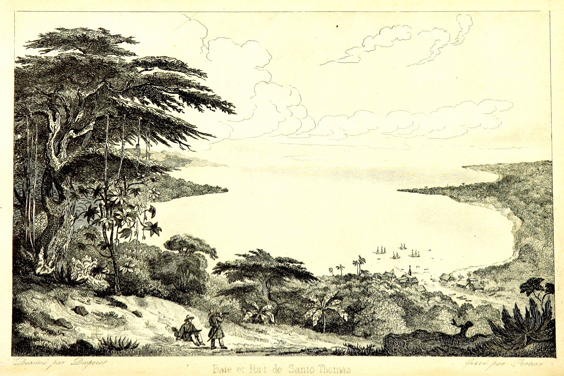 |
Santo Tomás de Castilla bay |
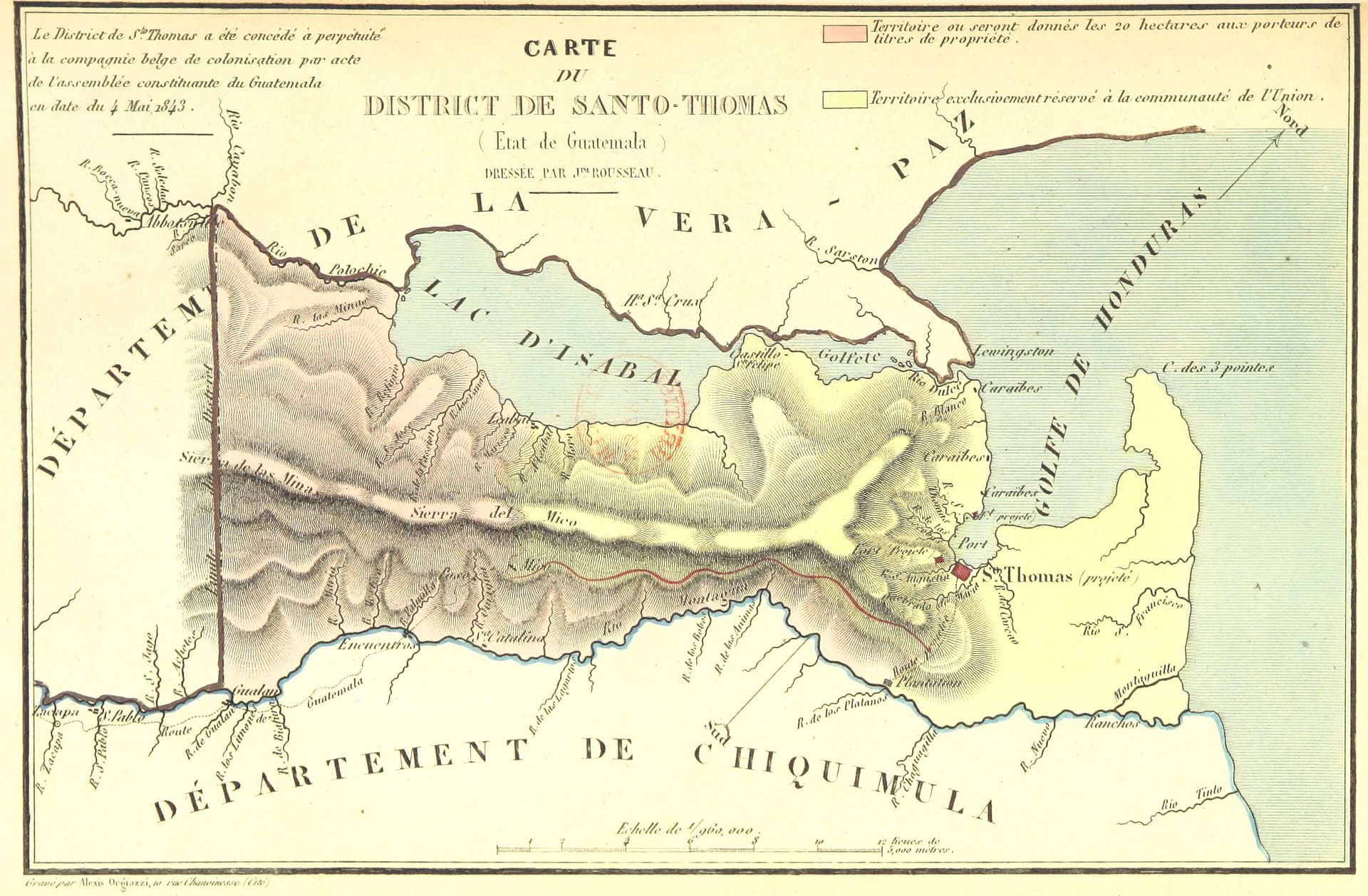 |
Izabal
lake and Santo Tomás district. Area in yellow is what had been given in
perpetuity to the catholic Belgians by Carrera's regime. |
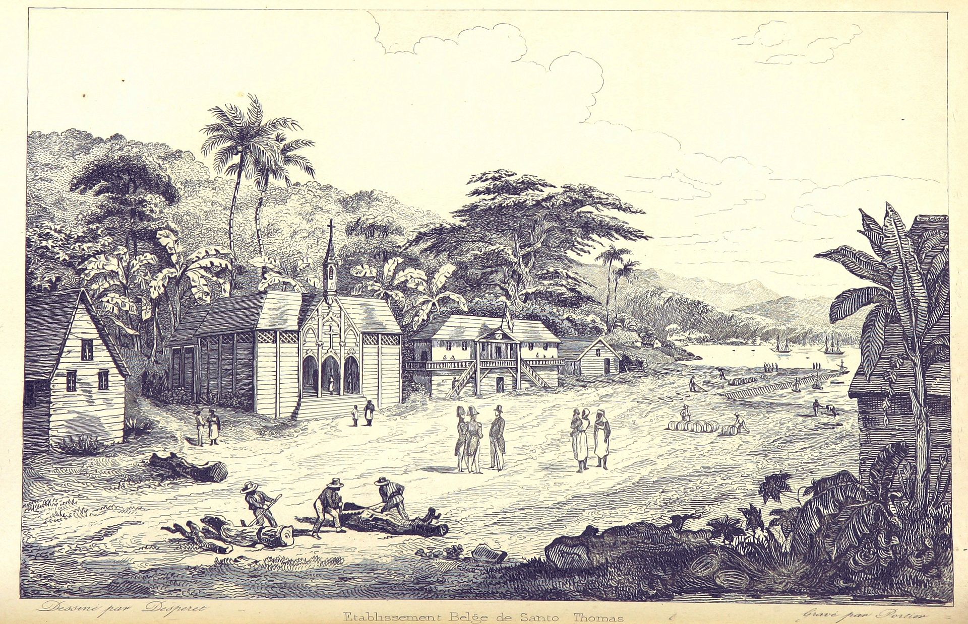 |
Santo Tomás town |
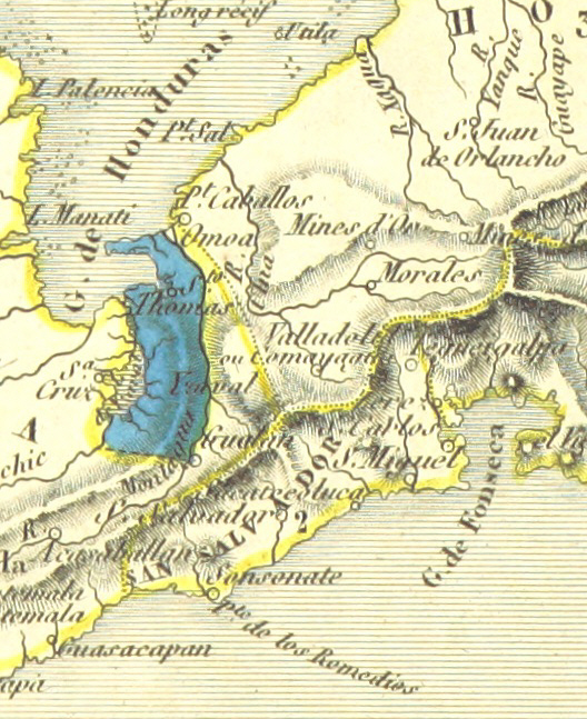 |
Map of the Belgian colony in Guatemala. |
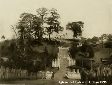
| German colony in Verapaz See also: Cobán As of 1850, Cobán, the capital of Alta Verapaz, had an estimated population of 12000.[5] Around 1890, British archeologist Alfred Percival Maudslay and his wife came to Guatemala, and visited Cobán.[6] Around the time the Maudslays visited Verapaz, a German colony had settled in the area thanks to generous concessions granted by liberal presidents Manuel Lisandro Barillas Bercián, José María Reyna Barrios and Manuel Estrada Cabrera.[7] The Germans had a very united and solid community and had several activities in the German Club (Deutsche Verein), in Cobán, which they had founded in 1888. Their main commercial activity was coffee plantations. Maudslay described the Germans like this: "There is a larger proportion of foreigners in Coban than in any other towns in the Republic: they are almost exclusively Germans engaged in coffee-planting, and some few of them in cattle-ranching and other industries; although complaints of isolation and of housekeeping and labour troubles are not unheard of amongst them, they seemed to me to be fortunate from a business point of view in the high reputation that the Vera Paz coffee holds in the market, and the very considerable commercial importance which their industry and foresight has brought to the district; and, from a personal point of view, in the enjoyment of a delicious climate in which their rosy-cheeked children can be reared in health and strength, and in all the comforts which pertain to a life half European and half tropical. Hotels or fondas appear to be scarce; but the hospitality of the foreign residents is proverbial."[8] |
ベラパスのドイツ植民地 こちらも参照のこと: コバン 1850年現在、アルタ・ベラパスの州都コバンの人口は12000人と推定されている[5]。 1890年頃、イギリスの考古学者アルフレッド・パーシバル・モーズレイ夫妻がグアテマラを訪れ、コバンを訪れた[6]。 [6]モードスレイ夫妻がベラパスを訪れた頃、自由主義的な大統領マヌエル・リサンドロ・バリジャス・ベルシアン、ホセ・マリア・レイナ・バリオス、マヌ エル・エストラーダ・カブレラが寛大な利権を与えたおかげで、ドイツ人コロニーがこの地域に定住していた[7]。ドイツ人は非常に団結した強固なコミュニ ティを持っており、1888年に設立したコバンのドイツ・クラブ(Deutsche Verein)でいくつかの活動を行っていた。彼らの主な商業活動はコーヒー農園であった。モードスレイはドイツ人をこう評した: 「コバンには、共和国のどの町よりも外国人の割合が多い: 彼らはほとんどコーヒー農園に従事するドイツ人ばかりで、牧畜業やその他の産業に従事する者も少なくない。彼らの間では、孤立感や家事・労働問題に対する 不満が聞かれないわけではないが、ヴェラパスコーヒーが市場で高い評価を得ていることや、彼らの産業と先見の明がこの地域にもたらした商業的重要性が非常 に大きいことなどから、ビジネスの観点からは幸運であると私には思われた; また、個人的な観点からは、バラ色の頬をした子供たちが健康でたくましく育ち、ヨーロッパと熱帯の半々の生活に必要なあらゆる快適さを享受できる、おいし い気候を享受できるという点である。ホテルやフォンダは少ないようだが、外国人居住者のもてなしは格別である」[8]。 |
 |
|
 |
|
 |
|
| The city was developed by German
coffee growers towards the end of the 19th century and was operated as
a largely independent dominion until World War II.[10] In 1888 a German
club was founded[11] and in 1935 a German school opened its doors in
Cobán. Until 1930, about 2000 Germans populated the city.[11] In 1941,
all Germans were expelled by the Guatemalan government, led at the time
by Jorge Ubico, because of pressure from the United States;[12] it has
also been suggested that Ubico wanted to seize control of the vast
amounts of land Germans owned in the area.[12] Many ended up in
internment camps in Texas and were later traded for American POWs held
in Germany. A sizable resident German population persists though, most
completely assimilated into the Guatemalan culture through
intermarriage. Multiple German architectural elements still remain
throughout Cobán. The Germans also set up Ferrocarril Verapaz, a railway which connected Cobán with Lake Izabal, operated from 1895 until 1963 and was a symbol for the wealth in this coffee-growing region those days.[10] During the Nazi era See also: Nazi Germany While the Nazis were in power in Germany (1933–1945), rumors circulated in Guatemala that the Germans in Verapaz wanted to establish themselves as a national socialist "new Germany". The Germans had acquired land, houses and farms through concessions from the liberal presidents who ruled from 1885 to 1920 in Guatemala and enjoyed privileges during the dictatorship of General Jorge Ubico, who admired the fascist policies of Benito Mussolini in Italy and Francisco Franco in Spain and the Nazism of Hitler in Germany. An incident involving the German community in Verapaz occurred when Nazi Germany asked its citizens to vote on the annexation of Austria to Germany: a German ship anchored in Puerto Barrios for this activity and those who attended were "counted" as Nazi supporters.[13][11] During World War II See also: World War II Tension increased when World War II between Germany, France and England started in 1939 with the German invasion of Poland and came to a critical point when Japan, an ally of the Germans, attacked the US military base of Pearl Harbor in Oahu, Hawaii on 7 December 1941. When the United States entered the war, it forced President Jorge Ubico to expel all Germans from Guatemala and to confiscate all of their properties.[14] The United States had a strong influence on the Guatemalan government, through concessions granted to American companies, such as the United Fruit Company who had a monopoly on the export of bananas and which practically paid no taxes to Guatemala, and that of railway transport through its subsidiary International Railroads of Central America (IRCA). The fruit company was the strongest pillar of Ubico's regime and was part of the American policy for the region since President Teddy Roosevelt started negotiations with Colombia to build the Panama Canal in 1903.[12] German males also were forced to leave their country and forced into the ranks of the German army. Guatemalan historian Francis Polo Sifontes wrote that during the Second World War many Germans were called for military service in his[clarification needed] country. After the war, some were imprisoned in concentration camps in Russia, and others claimed to be Guatemalans to avoid prison.[15] There are a number of names that Germans bequeathed their children; due to the mix with the Maya-Q'eqchi' population, many German names have remained in Q'eqchi' people since.[15][a] After the overthrow of Jacobo Árbenz See also: Jacobo Árbenz 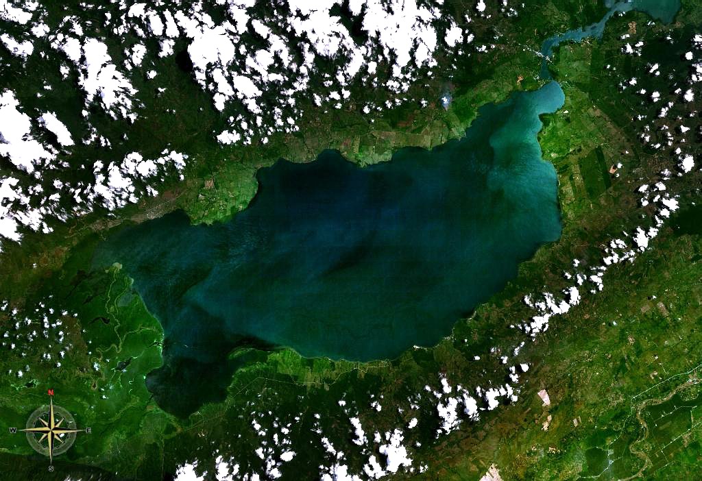 Izabal Lake in Guatemala. Originally, was the east border of the Northern Transversal Strip. After the counterrevolution of 1954, the Guatemalan government established the Council for Economic Planning and started using free-market strategies, advised by the World Bank and the International Cooperation Administration (ICA) of United States government.[16] CNPE and ICA created the Directorate General of Land Affairs (DGAA) which was responsible for dismantling and negating the effects of Decree 900 of Agragia Government Reform created by Jacobo Árbenz.[17] In 1959, Decree 1286 was passed into law and created the National Development Corporation and Economic Development of Petén (FYDEP), an agency of the Presidency of the Republic, responsible for colonization in the department of Petén. In practice, however, FYDEP was directed by the military and was an agency of the Ministry of Defense, [17] while in parallel DGAA handled the geographical strip bordering on the departmental boundary of Petén and the borders of Belize, Honduras and Mexico and which eventually became the Northern Transversal Strip. The first settler project in the FTN was in Sebol-Chinajá in Alta Verapaz. Sebol, then regarded as a strategic point and route through Cancuén River, which communicated with Petén through the Usumacinta River on the border with Mexico. The only road that existed was a dirt one built by President Lázaro Chacón in 1928. In 1958, during the government of General Miguel Ydígoras Fuentes the Inter-American Development Bank (IDB) financed infrastructure projects in Sebol.[b] In 1960, then-Army captain Fernando Romeo Lucas García inherited Saquixquib and Punta de Boloncó farms in northeastern Sebol. In 1963 he bought the farm "San Fernando" El Palmar de Sejux and finally bought the "Sepur" farm near San Fernando. During those years, Lucas was in the Guatemalan legislature and lobbied in Congress to boost investment in that area of the country.[18] In those years, the importance of the region was in livestock, exploitation of precious export wood and archaeological wealth. Timber contracts were granted to multinational companies such as Murphy Pacific Corporation from California, which invested US$30 million for the colonization of southern Petén and Alta Verapaz, and formed the North Impulsadora Company. Colonization of the area was made a process by which inhospitable areas of the FTN were granted to native peasants.[19] In 1962, the DGAA became the National Institute of Agrarian Reform (INTA), by Decree 1551 which created the law of Agrarian Transformation. In 1964, INTA defined the geography of the FTN as the northern part of the departments of Huehuetenango, Quiché, Alta Verapaz and Izabal and that same year priests of the Maryknoll order and the Society of the Sacred Heart began the first process of colonization along with INTA, carrying settlers from Huehuetenango to the Ixcán sector in Quiché.[20] "It is of public interest and national emergency, the establishment of Agrarian Development Zones in the area included within the municipalities: Santa Ana Huista, San Antonio Huista, Nentón, Jacaltenango, San Mateo Ixtatán, and Santa Cruz Barillas in Huehuetenango; Chajul and San Miguel Uspantán in Quiché; Cobán, Chisec, San Pedro Carchá, San Agustín Lanquín, Senahú, Cahabón and Chahal, in Alta Verapaz and the entire department of Izabal." Decreto 60–70, artítulo 1o.[21] The Northern Transversal Strip was officially created during the government of General Carlos Arana Osorio in 1970, by Decree 60–70 of the Congress, for agricultural development.[1] Oil potential  Guatemala oil reserves.[22] In 1971 indigenous Q'eqchi' people from 24 villages in the Cancuén area, in southern Petén and the north of Chisec were evicted by the Army because the region was rich in oil.[23] Since 1974, oil had been commercially extracted in the FTN vicinity following discoveries made by Shenandoah Oil and Basic Resources, which together operated the Rubelsanto oil field in Alta Verapaz. In 1976, when then-president Kjell Laugerud Garcia came to visit the Mayalán cooperative in Ixcán, Quiché—which had been formed just 10 years before—said: "Mayalán is seated on top of the gold", hinting that the North Transversal Strip would no longer be used for agriculture and the cooperative movement, but rather for strategic exploitation of natural resources.[24] After that visit, the two oil companies conducted explorations in Xacbal, near Mayalán in Ixcán, where they drilled the "San Lucas" well with unsuccessful results. These initial explorations, however, paved the way for future Ixcán and FTN oil experiments, and were also the main reason for building the dirt road that runs along the Strip. Shenandoah Oil, the National Institute of Agrarian Reform (INTA) and the Army Engineer Battalion coordinated the construction of that corridor between 1975 and 1979, which eventually allowed political, military and powerful businessmen of the time become owners of many lands where potential timber and oil wealth lay.[25] High Guatemalan government officers became large landowners and investors taking advantage of peasant transfer policies, privileged insider information, expansion of public credit and major development projects; the Army entered the business world with the Bank of the Army, pension funds and others.[26] |
1888年にはドイツ人クラブが設立され[11]、1935年にはコバ
ンにドイツ人学校が開校した。1930年までは約2000人のドイツ人が居住していた[11]。1941年、当時ホルヘ・ウビコが率いていたグアテマラ政
府によって、アメリカからの圧力によりすべてのドイツ人が追放された[12]。とはいえ、かなりの数のドイツ系住民が居住しており、そのほとんどは婚姻を
通じてグアテマラ文化に完全に同化している。コバンの至る所にドイツ建築の要素が残っている。 ドイツ人はまた、コバンとイザバル湖を結ぶ鉄道Ferrocarril Verapazを敷設し、1895年から1963年まで運行され、当時のこのコーヒー産地の富の象徴となった[10]。 ナチス時代 以下も参照のこと: ナチス・ドイツ ナチスがドイツで政権を握っていた時代(1933年~1945年)、グアテマラでは、ベラパスのドイツ人が民族社会主義的な「新ドイツ」の樹立を目指して いるという噂が流れた。ドイツ人たちは、1885年から1920年までグアテマラを統治した自由主義的な大統領たちからの利権によって土地、家屋、農場を 手に入れ、ホルヘ・ウビコ将軍の独裁政権時代には特権を享受していたが、彼はイタリアのベニート・ムッソリーニやスペインのフランシスコ・フランコのファ シズム政策やドイツのヒトラーのナチズムを賞賛していた。 ナチス・ドイツがオーストリアをドイツに併合するための投票を市民に求めたとき、ベラパスのドイツ人コミュニティが巻き込まれた事件が起きた。この活動のためにドイツ船がプエルト・バリオスに停泊し、参加した人々はナチス支持者として「カウント」された[13][11]。 第二次世界大戦中 以下も参照のこと: 第二次世界大戦 1939年、ドイツのポーランド侵攻によってドイツ、フランス、イギリスの間で第二次世界大戦が始まると緊張が高まり、1941年12月7日、ドイツの同 盟国である日本がハワイのオアフ島にある米軍真珠湾基地を攻撃したことで危機的状況に陥った。アメリカが参戦すると、ホルヘ・ウビコ大統領はグアテマラか らすべてのドイツ人を追放し、彼らの財産をすべて没収することを余儀なくされた[14]。バナナの輸出を独占し、グアテマラに実質的に税金を払っていな かったユナイテッド・フルーツ・カンパニーや、その子会社である中米国際鉄道(IRCA)を通じた鉄道輸送など、アメリカ企業に与えられた利権を通じて、 アメリカはグアテマラ政府に強い影響力を持っていた。テディ・ルーズベルト大統領が1903年にパナマ運河建設のためにコロンビアとの交渉を開始して以 来、果物会社はウビコ政権の強力な柱であり、この地域に対するアメリカの政策の一部であった[12]。グアテマラの歴史家フランシス・ポロ・シフォンテス は、第二次世界大戦中、多くのドイツ人が彼の国で兵役に召集されたと記している[要出典]。戦後、ロシアの強制収容所に収監された者もいれば、刑務所を避 けるためにグアテマラ人だと名乗った者もいた[15]。 ドイツ人が子供たちに遺した名前は数多くある。マヤ系ケチ族との混血のため、多くのドイツ人の名前はその後もケチ族に残っている[15][a]。 ハコボ・アルベンツ政権打倒後 以下も参照のこと: ヤコボ・アルベンツ グアテマラのイザバル湖。元々は北部横断帯の東の国境であった。 1954年の反革命後、グアテマラ政府は経済計画評議会を設立し、世界銀行とアメリカ政府の国際協力局(ICA)の助言を受け、自由市場戦略を採用し始め た[16]。 [16]CNPEとICAは、土地問題総局(DGAA)を設立し、ハコボ・アルベンツによって作成されたアグラジア政府改革令900号の影響を解体し、否 定する責任を負った[17]。1959年、政令1286号が成立し、共和国大統領府の機関である国家開発公社とペテン経済開発(FYDEP)が設立され、 ペテン県の植民地化を担当した。しかし実際には、FYDEPは軍によって指揮され、国防省の機関であった[17]。並行してDGAAは、ペテン県の県境と ベリーズ、ホンジュラス、メキシコの国境に接する地理的な帯を扱い、最終的に北部横断帯となった。 FTNにおける最初の入植事業は、アルタ・ベラパスのセボル-シナハで行われた。セボルは当時、メキシコとの国境にあるウスマシンタ川を通じてペテンと交 わるカンクエン川を通るルートであり、戦略的要衝と見なされていた。1928年にラサロ・チャコン大統領が建設した未舗装の道路しかなかった。1958 年、ミゲル・イディゴラス・フエンテス将軍の政権時代に、米州開発銀行(IDB)がセボルのインフラ・プロジェクトに融資した[b]。1960年、当時の 陸軍大尉フェルナンド・ロメオ・ルーカス・ガルシアは、セボル北東部のサキスキブとプンタ・デ・ボロンコ農場を相続した。1963年にはサン・フェルナン ド農場、エル・パルマル・デ・セジュクス農場を購入し、最終的にはサン・フェルナンド近郊のセプール農場を購入した。その間、ルーカスはグアテマラ議会議 員を務め、議会で同地域への投資を促進するよう働きかけた[18]。 当時、この地域の重要性は、畜産、貴重な輸出木材の開発、考古学的な富にあった。木材契約は、ペテン南部とアルタ・ベラパスの植民地化のために3,000 万米ドルを投資し、ノース・インプルサドーラ社を設立したカリフォルニアのマーフィー・パシフィック社などの多国籍企業に付与された。この地域の植民地化 は、FTNの人を寄せ付けない地域が先住民の農民に与えられるというプロセスで行われた[19]。 1962年、農地改革法を制定した政令1551号によって、DGAAは国立農地改革研究所(INTA)となった。1964年、INTAはFTNの地理をフ エヘテナンゴ、キチェ、アルタ・ベラパス、イザバルの各県の北部と定義し、同年、メリノール会と聖心会の司祭がINTAとともに最初の植民地化プロセスを 開始し、入植者をフエヘテナンゴからキチェのイクスカン地区へと運んだ[20]。 "公共利益と国家緊急事態であり、市町村に含まれる地域に農業開発地帯を設立することである: フエウエテナンゴのサンタ・アナ・ウイスタ、サン・アントニオ・ウイスタ、ネントン、ハカルテナンゴ、サン・マテオ・イクスタタン、サンタ・クルス・バリ ジャス、キチェのチャジュルとサン・ミゲル・ウスパンタン、アルタ・ベラパスのコバン、チセック、サン・ペドロ・カルチャ、サン・アグスティン・ランキ ン、セナフー、カハボン、チャハル、イザバル県全域。" Decreto 60-70、第1条[21]。 北部横断帯は、1970年のカルロス・アラナ・オソリオ将軍の政権時代に、農業開発のために議会令60-70号によって正式に作られた[1]。 石油の可能性 グアテマラの石油埋蔵量[22]。 1971年、ペテン南部とチセック北部のカンクエン地域の24の村の先住民ケクチ族が、この地域は石油が豊富であったため、軍によって立ち退きを命じられた[23]。 1974年以降、アルタ・ベラパスのルベルサント油田を操業していたシェナンドー石油とベーシック・リソーシズによって発見された石油は、FTN周辺で商 業的に採掘されていた。1976年、当時の大統領キェル・ラウゲルド・ガルシアがイクスカンのマヤラン協同組合を訪問した際、キチェ州はそのわずか10年 前に結成されたばかりであった: 「マヤランは金の上に座っている」と述べ、北横断帯がもはや農業や協同組合運動のために使われるのではなく、天然資源の戦略的開発のために使われることを 示唆した[24]。その訪問の後、2つの石油会社はイクスカンのマヤラン近郊のチャクバルで試掘を行い、そこで「サン・ルーカス」井を掘削したが、結果は 失敗に終わった。しかし、これらの最初の試掘は、将来のイクスカンとFTNの石油実験への道を開くものであり、ストリップに沿って未舗装の道路を建設する 主な理由にもなった。シェナンドー石油、国立農地改革研究所(INTA)、陸軍工兵大隊は、1975年から1979年にかけてその回廊の建設を調整し、最 終的に当時の政治家、軍人、有力実業家が、潜在的な木材と石油の富が眠っている多くの土地の所有者となることを可能にした[25]。 グアテマラ政府の高官は、農民移転政策、特権的なインサイダー情報、公的信用の拡大、大規模な開発プロジェクトなどを利用して大規模な土地所有者や投資家となり、陸軍は陸軍銀行、年金基金などとともにビジネスの世界に参入した[26]。 |
| Participation of Fernando Romeo Lucas García in FTN Main article: Fernando Romeo Lucas García In 1977, when he stepped down as defense minister to pursue his presidential campaign, general Fernando Romeo Lucas García also held the position of coordinator of the megaproject of the Northern Transversal Strip, whose main objective was to facilitate oil exploitation. By managing this project, Lucas García obtained greater knowledge and interaction with the transnational companies that were in the area, and increased his own personal economic interests in the region, given that his family owned land there and he had commercial relationships with Shenandoah Oil company.[27] Cuchumaderas case In 1977 the municipality of San Mateo Ixtatán signed a contract with the Cuchumaderas company for the "sanitation, reforestation, maintenance and exploitation of forests, based on the urgent need to build and maintain natural resources attacked by the pine beetle." Upon learning of the negotiation between the municipality and the company, town people forced the authorities to conduct an open meeting and explain the characteristics of the commitment; each of the members of the municipal corporation gave their account of the negotiation, showing contradictions that led to resignation of the mayor at the very same meeting. Despite threats received by some residents of San Mateo, they organized a local committee to defend the forest, and started a lawsuit against the company. As a result, forest extraction processes were stopped.[28] Cuchumaderas was closely related to the interests of the military leaders who held political power in the 1970s, and spread throughout the defined territory of the FTN; the forest wealth of San Mateo Ixtatán made it the target of economic interests in the Northern Transversal Strip. Ronald Hennessey, pastor of San Mateo Ixtatán during the Guatemalan Civil War, arrived in October 1980 amid people's fight against the presence of Cuchumaderas and accused in his writings as Cuchumaderas partners the following people: Lucas Garcia, FTN director when Cuchumaderas was founded, general Otto Spiegler Noriega, who was the Chief of Staff of the Army and later became Minister of Defense under Lucas García; Jorge Spiegler Noriega, manager of the National Forestry Institute (INAFOR), and then-colonel Rodolfo Lobos Zamora, commander of Military Zone of Quiché. However, later in the Commercial Register investigations showed that the owner of the company was a different person: it was the engineer Fernando Valle Arizpe.[c] Valle Arizpe had developed close relationships with senior officials and senior members of the government of Lucas García, especially Donaldo Alvarez Ruiz, the Minister of Interior.[29][d] During the Lucas García government (1 July 1978 – 23 March 1982) the Army Engineers Battalion built the road stretching from Cadenas (Petén / Izabal) to Fray Bartolomé de las Casas.[25] After the overthrow of Lucas Garcia on March 23, 1982, a military triumvirate headed by general Efraín Ríos Montt, along with colonels Horacio Maldonado Shaad and Francisco Gordillo rose to power. On June 2, 1982, international journalists conducted an interview with Ríos Montt, who said the following regarding Lucas García government and FTN: 1. What were the causes of the coup? There were many causes; government had reached such decomposition that it was slashing its roots; it had no roots or the people or institutions. As a result, it fell; plain and simple.[30] 2. Was there corruption in the previous government? I understand that there was a lot of corruption. It came to the point with corruption, that Guatemala – being a country with great economic reserves – lost its economic reserves in two years; and also practically mortgaged the country with large constructions made – such as peripheral highway loops – which really had no concept of planning from the point of view of transit and traffic.[31] 3. During Lucas García regime there were many social projects, much more than in previous governments, except in the revolutionary governments of (1944–1954). How will this government be different? It was not Lucas Garcia, but the government itself; they gave lots on the banks of the Transversal del Norte, to get (farmers) out of land where there was oil. Then they got land because they bought it to keep the money from the farm sales. They grabbed these people and threw it over the Transversal del Norte, and that is why they built the road to the Transversal del Norte: to avoid protests of the people who were taken from their land, where there was oil.[32] |
フェルナンド・ロメオ・ルーカス・ガルシアのFTN進出について 主な記事 フェルナンド・ロメオ・ルカス・ガルシア 1977年、フェルナンド・ロメオ・ルーカス・ガルシア将軍は、大統領選挙のために国防相を辞任した際、石油開発を促進することを主目的とした北部横断帯 の巨大プロジェクトのコーディネーターの職も兼任した。このプロジェクトを管理することで、ルーカス・ガルシアは、この地域に進出していた多国籍企業との 交流と知識を深め、また、彼の家族がこの地域に土地を所有し、シェナンドー石油会社と商取引関係にあったことから、この地域における彼自身の個人的な経済 的利益を増大させた[27]。 クチュマデラス事件 1977年、サン・マテオ・イスタタン自治体は、クチュマデラス社と「松くい虫に襲われた天然資源の建設と維持の緊急の必要性に基づく、森林の衛生、再植 林、維持、開発」に関する契約を結んだ。自治体と企業との交渉を知った町民は、当局に公開の会合を開き、公約の特徴を説明するよう強要した。自治体公社の 各メンバーは、交渉についての説明を行ったが、矛盾が露呈し、まさにその会合で市長が辞任するに至った。サン・マテオの一部の住民は脅迫を受けたにもかか わらず、森林を守るための地元委員会を組織し、会社を相手取って訴訟を起こした。その結果、森林伐採は中止された[28]。 クチュマデラスは、1970年代に政治権力を握っていた軍事指導者たちの利益と密接に関連しており、FTNの定義された領土全体に広がっていた。サン・マ テオ・イスタタンの森林の豊かさは、北部横断帯の経済的利益の標的となった。グアテマラ内戦中、サン・マテオ・イスタタンの牧師であったロナルド・ヘネ シー(Ronald Hennessey)は、1980年10月、クチュマデラスの存在に反対する人々の闘いのさなかに到着し、彼の著作の中で、以下の人々をクチュマデラスの パートナーとして非難した: クチュマデラス設立当時のFTN所長ルーカス・ガルシア、陸軍参謀総長で後にルーカス・ガルシアの下で国防大臣となったオットー・スピグレール・ノリエガ 大将、国立林業研究所(INAFOR)所長のホルヘ・スピグレール・ノリエガ、キチェ軍事地区司令官のロドルフォ・ロボス・サモラ大佐(当時)である。し かし、後の商業登記簿の調査で、この会社のオーナーは別人で、技師のフェルナンド・バジェ・アリスペ(Fernando Valle Arizpe)であることが判明した[c][29][d]。バジェ・アリスペは、ルーカス・ガルシア政府の高官や幹部、特に内務大臣のドナルド・アルバレ ス・ルイス(Donaldo Alvarez Ruiz)と親密な関係を築いていた[29][d]。 ルーカス・ガルシア政権時代(1978年7月1日~1982年3月23日)、陸軍工兵大隊はカデナス(ペテン/イザバル)からフレイ・バルトロメ・デ・ラス・カサスまで伸びる道路を建設した[25]。 1982年3月23日にルーカス・ガルシアが打倒された後、エフライン・リオス・モント将軍を筆頭に、オラシオ・マルドナド・シャード大佐、フランシス コ・ゴルディージョ大佐の3人の軍人が権力を握った。1982年6月2日、国際ジャーナリストがリオス・モントにインタビューを行い、ルーカス・ガルシア 政権とFTNについて次のように語った: 1. クーデターの原因は何だったのか? 多くの原因があった。政府は根を切り裂くような腐敗に達しており、根も国民も制度もなかった。その結果、政府は崩壊した。 2. 前政権に汚職はあったのか? 多くの汚職があったことは理解している。汚職によって、グアテマラは大きな経済的蓄えを持つ国であったが、2年間でその経済的蓄えを失い、また、周辺高速 道路のループのような、通過や交通の観点からの計画の概念が全くない大規模な建設によって、実質的に国を抵当に入れたのである[31]。 3. ルーカス・ガルシア政権時代には、1944年から1954年の革命政権を除けば、それ以前の政権よりもはるかに多くの社会事業が行われた。今回の政府はどう違うのだろうか? ルーカス・ガルシアではなく、政府自身が、石油のある土地から(農民を)追い出すために、トランスヴェルサル・デル・ノルテの土手に土地を与えた。農民を 石油のある土地から追い出すためだ。だから彼らは、石油のある土地を奪われた人々の抗議を避けるために、ノルテ横断道路を建設したのである[32]。 |
| Civil war in Guatemala Main article: Guatemala Civil War The Guerrilla Army of the Poor Main article: Ejército Guerrillero de los Pobres On January 19, 1972, members of a new Guatemalan guerrilla movement entered Ixcán from Mexico, and were accepted by many farmers; in 1973, after an explorative foray into the municipal seat of Cotzal, the insurgent group decided to set up camp underground in the mountains of Xolchiché, municipality of Chajul.[33] In 1974 the insurgent guerrilla group held its first conference, where it defined its strategy of action for the coming months and called itself Guerrilla Army of the Poor (-Ejército Guerrillero de los Pobres -EGP-). In 1975 the organization had spread around the area of the mountains of northern municipalities of Nebaj and Chajul. As part of its strategy EGP agreed to perform acts that notoriety was obtained and through which also symbolize the establishment of a "social justice" against the inefficiency and ineffectiveness of the judicial and administrative organs of the State. They saw also that with these actions the indigenous rural population of the region is identified with the insurgency, thus motivating joining their ranks. As part of this plan was agreed to so-called "executions". To determine who would be these people subject to "execution", the EGP attended complaints received from the public. For example, they selected two victims: Guillermo Monzón, who was a military Commissioner in Ixcán and José Luis Arenas, the largest landowner in the area of Ixcán, and who had been reported to the EGP for allegedly having land conflicts with neighboring settlements and abusing their workers.[33][e] On Saturday, 7 June 1975, José Luis Arenas was killed by unknowns when he was in the premises of his farm "La Perla" to pay wage workers. In front of his office there were approximately two to three hundred people to receive their payment and four members of EGP mixed among farmers. Subsequently, the guerrilla members destroyed the communication radio of the farm and executed Arenas. After having murdered José Luis Arenas, guerrilla members spoke in Ixil language to the farmers, informing them that they were members of the Guerrilla Army of the Poor and had killed the "Tiger Ixcán." They requested to prepare beasts to help the injured and were transported to Chajul to receive medical care. Then the attackers fled towards Chajul.[33] José Luis Arenas' son, who was in San Luis Ixcán at the time, seek refuge in a nearby mountain, waiting for a plane to arrive to take him to the capital, to immediately report the matter to the Minister of Defense. The defense minister replied, "You are mistaken, there are no guerrillas in the area".[33] Panzós massacre Main article: Panzós massacre In Alta Verapaz in the late nineteenth century German farmers came to concentrate in their hands three-quarters of the total 8686 km2 area of the department. In this department came insomuch land grabbing and women [slaves] by German agricultural entrepreneurs, a political leader noted that farmers disappeared from their villages overnight, fleeing the farmers. Julio Castellanos Cambranes[15] Also located in the Northern Transversal Strip, the valley of the Polochic River had been inhabited since ancient times by k'ekchí and P'okomchi people. In the second half of the nineteenth century, President Justo Rufino Barrios (1835–1885) allocated land in the area to German farmers.[15] Decree 170 (Census Redemption Decree) facilitated the expropriation of Indian land in favor of the Germans, because it promoted the auction of communal lands.[15] Since that time, the main economic activity has been export-oriented, especially coffee, bananas and cardamom.[34] Communal property used for subsistence farming became private property which led to the cultivation and mass marketing of agricultural products. Therefore, the fundamental characteristic of the Guatemalan production system has since that time been the accumulation of property in few hands,[35] and a sort of "farm servitude" based on the exploitation of "farmer settlers".[f][36] In 1951, an agrarian reform law that expropriated idle land from private ownership was enacted, but in 1954, with the National Liberation Movement coup supported by the United States, most of the expropriated land was awarded back to its former landowners. Flavio Monzón was appointed mayor and in the next twenty years he became one of the largest landowners in the area.[37] In 1964, several communities settled for decades on the shore of Polochic River claimed property titles to INTA which was created in October 1962, but the land was awarded to Flavio Monzón. A Mayan peasant from Panzós later said that Flavio Monzón "got the signatures of the elders before he went before INTA to talk about the land. When he returned, gathered the people and said that, by an INTA mistake, the land had gone to his name." Throughout the 1970s, Panzós farmers continued to claim INTA regularization of land ownership, receiving legal advice from the FASGUA (Autonomous Trade Union Federation of Guatemala), an organization that supported the peasants' demands through legal procedures. However, no peasant received a property title, ever. Some obtained promises while others got provisional property titles, and also some only received permission to plant. The peasants began to suffer evictions from their land by farmers, the military and local authorities in favor of the economic interests of Izabal Mining Operations Company (EXMIBAL) and Transmetales.[38][g] In 1978 a military patrol was stationed a few kilometers from the county seat of Panzós, in a place known as "Quinich". At this time organizational capacity of peasant had increased through committees who claimed titles to their land, a phenomenon that worried the landlord sector. Some of these owners -among them Flavio Monzón- stated: "Several peasants living in the villages and settlements want to burn urban populations to gain access to private property",[39] and requested protection from Alta Verapaz governor.[h] On 29 May 1978, peasants from Cahaboncito, Semococh, Rubetzul, Canguachá, Sepacay villages, finca Moyagua and neighborhood La Soledad, decided to hold a public demonstration in the Plaza de Panzós to insist on the claim of land and to express their discontent caused by the arbitrary actions of the landowners and the civil and military authorities. Hundreds of men, women, indigenous children went to the square of the municipal seat of Panzós, carrying their tools, machetes and sticks. One of the people who participated in the demonstration states: "The idea was not to fight with anyone, what was required was the clarification of the status of the land. People came from various places and they had guns." There are different versions on how the shooting began: some say it began when "Mama Maquín" -an important peasant leader- pushed a soldier who was in her way; others argue that it started because people kept pushing trying to get into the municipality, which was interpreted by the soldiers as an aggression.[40] The mayor at the time, Walter Overdick, said that "people of the middle of the group pushed those who in front."[40] A witness says one protester grabbed the gun from a soldier but did not use it and several people argue that a military voice yelled: One, two, three! Fire!"[41] In fact, the lieutenant who led the troops gave orders to open fire on the crowd. The shots that rang for about five minutes, were made by regulation firearms carried by the military as well as the three machine guns located on the banks of the square. 36 Several peasants with machetes wounded several soldiers. No soldier was wounded by gunfire. The square was covered with blood. Immediately, the army closed the main access roads,[42] despite that "indigenous felt terrified." An army helicopter flew over the town before picking up wounded soldiers.[41] Escalation of violence and "scorched earth" After the "execution" of José Luis Arenas population of Hom, Ixtupil, Sajsivan and Sotzil villages, neighbors of La Perla and annexes, increased support for the new guerrilla movement, mainly due to the land dispute that peasants kept with the owners of the farm for several years and that the execution was seen as an act of "social justice". The murder owner of the farm "La Perla", located in the municipality of Chajul, resulted in the escalation of violence in the area: part of the population moved closer to the guerrillas, while another part of the inhabitants of Hom kept out of the insurgency. In 1979 the owners of the farm "La Perla" established links with the army and for the first time a military detachment was installed within the property; in this same building the first civil patrol of the area was established. The Army high command, meanwhile, was very pleased with the initial results of the operation and was convinced it had succeeded in destroying most of the social basis of EGP, which had to be expelled from the "Ixil Triangle". At this time the presence of EGP in the area decreased significantly due to the repressive actions of the Army, who developed its concept of "enemy" without necessarily including the notion of armed combatants; the officers who executed the plan were instructed to destroy all towns suspect of cooperate with EGP and eliminate all sources of resistance. Army units operating in the "Ixil Triangle" belonged to the Mariscal Zavala Brigade, stationed in Guatemala City. Moreover, although the guerrillas did not intervene directly when the army attacked the civilian population allegedly because they lacked supplies and ammunition, it did support some survival strategies. It streamlined, for example, "survival plans" designed to give evacuation instructions in assumption that military incursions took place. Most of the population began to participate in the schemes finding that them represented their only alternative to military repression.[43] Since late 1981 the Army applied a strategy of "scorched earth" in Quiché,[44] to eliminate the guerrilla social support EGP.[45] In some communities of the region's military forced all residents to leave their homes and concentrate in the county seat under military control. Some families obeyed; others took refuge in the mountains. K'iche's who took refuge in the mountains, were identified by the Army with the guerrillas and underwent a military siege, and continuous attacks that prevented them from getting food, shelter and medical care. La Llorona massacre, El Estor La Llorona, located about 18 kilometers from El Estor, department of Izabal (part of the Northern Transversal Strip), was a small village with no more than twenty houses. Most of the first settlers arrived from the areas of Senahú and Panzós, both in Alta Verapaz. In 1981 the total population was about 130 people, all belonging to q'eqchi' ethnic group. Few people spoke Spanish and most work in their own cornfields, sporadically working for the local landowners. In the vicinity are the villages El Bongo, Socela, Benque, Rio Pita, Santa Maria, Big Plan and New Hope. Conflicts in the area were related to land tenure, highlighting the uncertainty about the boundaries between farms and communities, and the lack of titles. As in the National Institute of Agrarian Transformation (INTA) was not registered a legitimate owner of land occupied La Llorona, the community remained in the belief that the land belonged to the state, which had taken steps to obtain title property. However, a farmer with great influence in the area occupied part of the land, generating a conflict between him and the community; men of the village, on its own initiative, devised a new boundary between community land and the farmer, but the problem remained dormant.[46] In the second half of the seventies were the first news about the presence of guerrillas in the villages, the commander aparacimiento Ramon, talking to people and saying they were the Guerrilla Army of the Poor. They passed many villages asking what problems people had and offering to solve them. The told peasants that the land belonged to the poor and that they should trust them. In 1977, Ramon - a guerrilla commander - regularly visited the village of La Llorona and after finding that the issue of land was causing many problems in the community, taught people to practice new measurements, which spread fear among landowners. That same year, the group under Ramon arbitrarily executed the Spanish landowner José Hernández, near El Recreo, which he owner. Following this, a clandestine group of mercenaries, dubbed "fighters of the rich" was formed to protect the interests of landlords; public authority of El Estor organized the group and paid its members, stemming from the funding of major landowners. The group, irregular, was related to the military commissioners of the region and with commanders of the Army, although mutual rivalries also took place. The secret organization murdered several people, including victims who had no connection whatsoever with insurgent groups.[46] In December 1978, the EGP group leader, Ramon, was captured by soldiers of the military detachment in El Estor and transferred to the military zone of Puerto Barrios; after two years returned to El Estor; but this time as an officer in the Army G2 and joined a group of soldiers that came to the village. On the evening of 28 September 1981, an army officer accompanied by four soldiers and a military commissioner met with about thirty civilians. At seven o'clock, over thirty civilians, mostly from "Nueva Esperanza', including several 'informants' known to military intelligence, gathered around La Llorona along with some military commissioners and a small group of soldiers and army officers. Then they entered the village. Civilians and commissioners entered twelve houses, and each of them were pulling men and shot them dead outside their own homes; those who tried to escape were also killed. Women who tried to protect their husbands were beatn. While the military commissioners and civilians executed men, soldiers subtracted belongings of the victims; within half an hour, the authors of the assault left the village. The victim bodies, fourteen in all, were in front of houses. Women, despite having been threatened with death if tell what happened, ran to the nearest village, El Bongo, for help. After a few hours, women came back with people who helped to bury the bodies. Days later, widows, with almost 60 fatherless children were welcomed by the parish of El Estor for several days, until the soldiers forced them to return to their village. Two widows of those executed on September 29 established close relations with the military commissioners from Bongo. This situation led to divisions that still exist in the community.[46] The economic and social activity was disrupted in the village: widows had to take the jobs of their husbands; because of their lack of knowledge in the cultivation of land, harvested very little corn and beans. There were diseases, especially among children and the elderly, there was no food or clothing. The teacher of the village came only part-time, mostly out of fear, but left after he realized it was not worth to stay because young people had to work. Nor could they spend money on travel. The village had no teacher for the next four years. The events generated finally the breakup of the community. Some village women though that their husbands were killed because of three others who were linked with the guerrillas and were involved in a land dispute.[46] According to the Historical Clarification Commission, the landlord with whom the villagers had the land dispute took advantage of the situation to appropriate another twelve acres of land.[46] 1982 coup d'état Main article: 1982 Guatemalan coup d'état After the overthrow of Lucas Garcia March 23, 1982, rose to power a military triumvirate headed by General Efrain Rios Montt, along with Horacio Maldonado Shaad colonels and Francisco Gordillo. By 1983, it was estimated that 60% of the territory of Alta Verapaz was owned by military: including presidents Kjell Eugenio Laugerud, Fernando Romeo Lucas García . Other massacres perpetrated by the Army The report of the Recovery of Historical Memory lists 422 massacres committed by both sides in the conflict;[47] however, it also states that they did the best they could in terms of obtaining information and therefore the list is incomplete; therefore here are the cases that have also been documented in other reports as well. Chajul, Nebaj and Ixcán massacres during Guatemala Civil War List of massacres perpetrated by the EGP According to a report by the rightist magazine "Crónica", there were 1258 guerrilla actions against civilians and infrastructure in Guatemala, including more than two hundred murders, sixty eight kidnappings, eleven bombs against embassies and three hundred twenty-nine attacks against civilians. Almost all guerrilla massacres occurred in 1982 when further militarization reigned and there was widespread presence of PAC in communities; many of them were victims of non-cooperation with the guerrillas and in some cases they came after a previous attack by the PAC. In the massacres perpetrated by the guerrillas there is no use of informants, or concentration of population, or separation of groups; also, there are no recounts of rape or repetitive slaughter. There are cases of razed villages and less tendency to mass flight, even though it occurred in some cases, the use of lists was also more frequent.[49] In a publication of the Army of Guatemala, sixty massacres perpetrated by the EGP were reported, arguing that they were mostly ignored by REHMI and the Historical Clarification Commission reports.[50] It is also reported that in mid-1982, 32 members of "Star Guerrilla Front " were shot for not raising the EGP flag.[51] Chajul, Nebaj and Ixcán massacres during Guatemala Civil War |
グアテマラ内戦 主な記事 グアテマラ内戦 貧民ゲリラ軍 主な記事 貧民ゲリラ軍団 1972年1月19日、グアテマラの新しいゲリラ運動のメンバーがメキシコからイクスカンに入り、多くの農民に受け入れられた。1973年、コツァルの市 庁舎に探検的に侵入した後、反乱グループはチャジュルの自治体であるソルチチェの山中に地下キャンプを張ることを決定した[33]。 1974年、反乱ゲリラ・グループは最初の会議を開き、そこで今後数ヶ月の行動戦略を定め、自らを貧民ゲリラ軍(Ejército Guerrillero de los Pobres -EGP)と名乗った。1975年、この組織はネバジとチャジュルの北部自治体の山間部一帯に広がっていた。EGPは、その戦略の一環として、悪評を得る ような行為を行うことに同意し、それを通して、国の司法・行政機関の非能率性や非効率性に対抗する「社会正義」の確立を象徴するものでもあった。彼らはま た、こうした行為によって、この地域の先住民の農村住民が反乱軍と同一視され、その結果、彼らの隊列に加わる動機付けになると考えた。この計画の一環とし て、いわゆる「処刑」が合意された。処刑」の対象となる人々を決定するために、EGPは一般市民から寄せられた苦情に立ち会った。例えば、彼らは2人の犠 牲者を選んだ: イクスカンの軍事委員であったギジェルモ・モンソンと、イクスカンの地域で最大の地主であり、近隣の集落との土地紛争や労働者の虐待の疑いでEGPに報告 されていたホセ・ルイス・アレナスである[33][e]。 1975年6月7日土曜日、ホセ・ルイス・アレナスは、賃金労働者に賃金を支払うために彼の農場「ラ・ペルラ」の敷地内にいたところを何者かに殺害され た。彼の事務所の前には、支払いを受けるためにおよそ200~300人の人々がおり、農民の中にEGPのメンバー4人が混じっていた。その後、ゲリラのメ ンバーは農場の通信無線を破壊し、アレナスを処刑した。ホセ・ルイス・アレナスを殺害した後、ゲリラのメンバーは農民たちにイシル語で話しかけ、自分たち は貧民ゲリラ軍のメンバーであり、「タイガー・イクスカン 」を殺したと告げた。彼らは負傷者を助けるために獣を用意するよう要求し、医療を受けるためにチャジュルに運ばれた。その後、襲撃者たちはチャジュルに向 かって逃走した[33]。 当時サン・ルイス・イクスカンにいたホセ・ルイス・アレナスの息子は、近くの山に避難し、すぐに国防大臣に報告するため、首都に向かう飛行機の到着を待った。国防相は「あなたは間違っている、この地域にゲリラはいない」と答えた[33]。 パンソスの虐殺 主な記事 パンソスの虐殺 19世紀後半、アルタ・ベラパスでは、ドイツ人農民が同県の総面積8686km2の4分の3を彼らの手に集中させるようになった。この県では、ドイツ人農 業起業家による土地の強奪と女性[奴隷]の略奪がひどく、ある政治指導者は、農民が一夜にして村から姿を消し、農民から逃げ出したと指摘した。 フリオ・カステジャーノス・カンブラネス[15]。 同じく北部横断帯に位置するポロチチ川の谷間には、古くからケクチ族とプコムチ族が住んでいた。19世紀後半、フスト・ルフィノ・バリオス大統領 (1835年-1885年)は、この地域の土地をドイツ人農民に割り当てた[15]。政令170号(国勢調査贖罪令)は、共同所有地の競売を促進したた め、ドイツ人に有利なインディアンの土地収用を容易にした[15]。したがって、グアテマラの生産システムの基本的な特徴は、当時から少数の手に財産が蓄 積されることであり[35]、「農民入植者」の搾取に基づく一種の「農場隷属」であった[f][36]。 1951年、遊休地を私有地から収用する農地改革法が制定されたが、1954年、アメリカの支援を受けた民族解放運動のクーデターにより、収用された土地 のほとんどが元の地主に返還された。フラビオ・モンソンは市長に任命され、その後20年間でこの地域最大の土地所有者のひとりとなった[37]。1964 年、ポロチッチ川沿岸に数十年にわたって定住していたいくつかのコミュニティが、1962年10月に設立されたINTAに対して所有権を主張したが、土地 はフラビオ・モンソンに与えられた。後にパンソスのマヤの農民は、フラビオ・モンソンが「土地の話をするためにINTAの前に行く前に、長老たちの署名を もらった。彼が戻ってくると、民衆を集めて、INTAの手違いで土地が自分の名義になってしまったと言った」。1970年代を通じて、パンソスの農民たち はINTAによる土地所有権の正規化を主張し続け、法的手続きを通じて農民たちの要求を支援する組織であるFASGUA(グアテマラ自治労働組合連合会) から法的助言を受けた。しかし、所有権を得た農民は一人もいなかった。ある農民は約束を取り付け、ある農民は仮の所有権を得た。農民たちは、イザバル鉱山 操業会社(EXMIBAL)とトランスメタレスの経済的利益を優先して、農民、軍、地方当局による土地からの立ち退きに苦しむようになった[38] [g]。 1978年、軍のパトロール隊が、パンソス郡庁所在地から数キロ離れた「キニチ」として知られる場所に駐屯した。この頃、土地の所有権を主張する委員会を 通じて農民の組織能力が高まっており、この現象は地主部門を悩ませた。フラビオ・モンゾンをはじめとする農民の中には、次のように述べた者もいた: 「村や集落に住む何人かの農民は、私有地へのアクセスを得るために都市住民を焼こうとする」[39]と述べ、アルタ・ベラパス州知事に保護を要請した [h]。 1978年5月29日、カハボンチート、セモコッチ、ルベツル、カンガチャ、セパカイ村、モヤグア農園、ラ・ソレダッド近隣の農民たちは、土地の領有権を 主張し、地主と市民・軍当局の恣意的な行動による不満を表明するために、パンソス広場で公開デモを行うことを決定した。何百人もの男、女、先住民の子供た ちが、道具、鉈、棒を持って、パンソス市庁舎の広場に向かった。デモに参加した一人はこう語る: 「必要なのは土地の地位を明確にすることだった。人々はいろいろな場所からやってきて、銃を持っていた」。 ある者は、農民の重要な指導者である 「ママ・マキーン 」が邪魔になった兵士を突き飛ばしたことから始まったと言い、またある者は、人々が自治体内に入ろうとして押し続けたことから始まったと主張し、兵士たち はこれを侵略と解釈した[40]。 40] 当時の市長であったヴァルター・オーヴァーディックは、「集団の真ん中にいた人々が前にいた人々を押した」と述べている[40][40] 目撃者によれば、抗議者の一人が兵士から銃を奪い取ったが、使用はしなかったという: 1、2、3!実際、部隊を率いた中尉は群衆に発砲するよう命令した。 約5分間鳴り響いた銃声は、広場の土手に設置された3挺の機関銃だけでなく、軍が携行していた規定の銃器によっても発せられた。36 ナタを持った数人の農民が数人の兵士を負傷させた。銃撃で負傷した兵士はいなかった。広場は血で覆われた。 先住民は恐怖を感じていた」にもかかわらず、軍は直ちに主要なアクセス道路を閉鎖した[42]。負傷兵を収容する前に軍のヘリコプターが町の上空を飛んだ[41]。 暴力の激化と 「焦土化」 ホセ・ルイス・アレナスの「処刑」後、ラ・ペルラの近隣にあるホム村、イクストゥピル村、サジバン村、ソツィル村の住民は、新たなゲリラ運動への支持を強 めたが、その主な理由は、農民が数年間農園の所有者と争っていた土地紛争であり、処刑は「社会正義」の行為と見なされたことであった。 チャジュル自治体にある農場「ラ・ペルラ」の所有者が殺害されたことで、この地域の暴力が激化した。住民の一部はゲリラに接近し、ホムの住民の別の一部は 反乱に関わらないようにした。1979年、「ラ・ペルラ」農場の所有者は軍との関係を築き、初めて軍の分遣隊が敷地内に設置された。一方、陸軍上層部は、 この作戦の最初の成果に非常に満足し、「イクシル・トライアングル」から追放しなければならなかったEGPの社会基盤の大部分を破壊することに成功したと 確信した。この頃、武装戦闘員という概念を必ずしも含むことなく「敵」の概念を発展させた陸軍の抑圧的な行動により、この地域におけるEGPの存在は著し く減少した。計画を実行した将校たちは、EGPに協力する疑いのあるすべての町を破壊し、すべての抵抗源を排除するよう指示された。イクシル・トライアン グル」で活動する陸軍部隊は、グアテマラ・シティに駐屯するマリスカル・サバラ旅団に属していた。さらに、ゲリラは物資や弾薬が不足していたため、軍が民 間人を攻撃したときには直接介入しなかったとされるが、いくつかの生存戦略を支援した。たとえば、軍の侵攻を想定して避難指示を出すための「生存計画」を 合理化した。住民の多くは、それが軍事的弾圧に代わる唯一の選択肢であることを知り、この計画に参加し始めた[43]。 1981年後半から陸軍はゲリラの社会的支援であるEGPを排除するために、キチェで「焦土化」戦略を適用した[44]。従った家族もいれば、山に避難し た家族もいた。山に避難したキチェ族は、軍によってゲリラと同一視され、軍の包囲を受け、継続的な攻撃を受け、食料、避難所、医療を受けることができなく なった。 ラ・ジョロナの虐殺、エル・エストル ラ・ジョロナは、イサバル県エル・エストルから約18キロ(北部横断帯の一部)に位置し、20軒もない小さな村だった。最初の入植者のほとんどは、アルタ・ ベラパスのセナフー(Senahú)とパンソス(Panzós)の地域からやってきた。1981年の総人口は約130人で、全員がケチ族に属していた。ス ペイン語を話す人はほとんどおらず、ほとんどの人が自分たちのトウモロコシ畑で働き、散発的に地元の地主の下で働いていた。周辺には、エル・ボンゴ村、ソ セラ村、ベンケ村、リオ・ピタ村、サンタ・マリア村、ビッグ・プラン村、ニュー・ホープ村がある。この地域の紛争は土地の所有権に関連しており、農地とコ ミュニティーの境界が不明確であることや、所有権の欠如が浮き彫りになっている。国立農地改革研究所(INTA)が、ラ・ロロナの土地の正当な所有者とし て登録されていなかったため、コミュニティは、土地は国に帰属するという信念を持ち続け、所有権を得るための措置をとっていた。しかし、この地域で大きな 影響力を持つ農民が土地の一部を占有していたため、彼とコミュニティとの間に対立が生じた。村の男たちは、自らの主導で、コミュニティの土地と農民との間 に新たな境界線を考案したが、問題は眠ったままであった[46]。 70年代後半には、村にゲリラが存在するという最初のニュースが流れた。司令官のアパラシミエント・ラモンは、人々に話しかけ、自分たちは貧民ゲリラ軍だ と言った。彼らは多くの村々を通り過ぎ、人々が抱えている問題を尋ね、その解決を申し出た。彼らは農民たちに、土地は貧しい人々のものであり、彼らを信じ るべきだと言った。1977年、ゲリラの司令官であったラモンは、ラ・ロロナ村を定期的に訪れ、土地の問題が地域社会に多くの問題を引き起こしていること を知ると、人々に新しい測り方を教え、地主たちに恐怖心を広めた。同じ年、ラモン率いるグループは、スペイン人地主ホセ・エルナンデスを、彼が所有するエ ル・レクレオの近くで恣意的に処刑した。この後、地主の利益を守るため、「金持ちの戦士」と呼ばれる傭兵の秘密グループが結成された。エル・エストルの公 権力がこのグループを組織し、大土地所有者の資金を原資としてメンバーに報酬を支払った。エル・エストルの公権力がグループを組織し、大土地所有者の資金 源からメンバーに報酬を支払っていた。非正規のこのグループは、地域の軍事委員や陸軍の司令官と関係があったが、相互対立も起こった。この秘密組織は、反 乱グループとは全く関係のない犠牲者も含め、数人を殺害した[46]。 1978年12月、EGPグループのリーダーであったラモンは、エル・エストルの軍事分遣隊の兵士に捕らえられ、プエルト・バリオスの軍事地帯に移送され た。2年後、エル・エストルに戻ったが、今度は陸軍G2の将校として、村にやってきた兵士のグループに加わった。1981年9月28日の夜、4人の兵士と 軍事委員を連れた陸軍将校が、約30人の市民と面会した。7時、30人以上の民間人、そのほとんどが「ヌエバ・エスペランサ」出身者で、軍情報部に知られ ている数人の「情報提供者」を含み、数人の軍事委員と少数の兵士と陸軍将校のグループとともに、ラ・ロロナの周りに集まった。そして村に入った。民間人と 委員は12軒の家に入り、それぞれ男を引っ張り、自分の家の外で射殺した。逃げようとした者も殺された。夫を守ろうとした女性は殴られた。軍事委員と民間 人が男たちを処刑している間、兵士たちは犠牲者の持ち物を抜き取り、30分もしないうちに、襲撃の実行者たちは村を去った。被害者の遺体は全部で14体、 家の前にあった。女性たちは、事情を話せば殺すと脅されたにもかかわらず、助けを求めて一番近い村エル・ボンゴに走った。数時間後、女性たちは遺体の埋葬 を手伝う人々を連れて戻ってきた。数日後、60人近い父親のいない子供たちを連れた未亡人たちは、エル・エストルの教区で数日間歓迎されたが、兵士たちは 彼女たちを村に強制的に連れ戻した。9月29日に処刑された2人の未亡人は、ボンゴの軍事委員と親密な関係を築いた。このような状況は、地域社会に今も存 在する分裂をもたらした[46]。 未亡人は夫の仕事を引き受けなければならず、土地耕作の知識がないため、トウモロコシや豆の収穫はほとんどなかった。特に子供と老人の間には病気が蔓延 し、食べ物も衣服もなかった。村の教師はパートタイムでしか来なかったが、若者たちは働かなければならないため、滞在する価値がないことに気づいて去って いった。旅費を使うこともできなかった。その後4年間、村には教師がいなかった。この出来事は、ついにコミュニティの崩壊を招いた。村の女性の中には、ゲ リラとつながっていて土地争いに巻き込まれていた他の3人のせいで夫が殺されたと考える者もいた[46]。 歴史解明委員会によれば、村人たちが土地紛争を起こした地主は、この状況を利用してさらに12エーカーの土地を横領した[46]。 1982年クーデター 主な記事 1982年グアテマラ・クーデター 1982年3月23日、ルーカス・ガルシアの打倒後、オラシオ・マルドナド・シャード大佐、フランシスコ・ゴルディージョとともに、エフレイン・リオス・ モント将軍を首班とする軍事三羽烏が権力を握った。1983年までに、アルタ・ベラパスの領土の60%が軍によって所有されたと推定された:大統領キェ ル・エウジェニオ・ラウゲルード、フェルナンド・ロメオ・ルーカス・ガルシアを含む。 軍によるその他の虐殺 歴史的記憶の回復の報告書は、紛争で両陣営によって行われた422件の虐殺をリストアップしている[47]が、情報を得るという点では最善を尽くしたのでリストは不完全であるとも述べている。 グアテマラ内戦中のチャフル、ネバジ、イクスカンの虐殺 EGPによる虐殺のリスト 右派雑誌『Crónica』の報告書によると、グアテマラでは1258件のゲリラが市民やインフラに対して行動を起こし、その中には200件以上の殺人、 68件の誘拐、11件の大使館に対する爆弾、329件の市民に対する攻撃が含まれている。ゲリラによる虐殺のほとんどは、軍国主義化がさらに進み、PAC が地域社会に広く存在するようになった1982年に起こった。その多くはゲリラへの非協力の犠牲者であり、PACによる以前の攻撃の後に起こったケースも あった。ゲリラによる虐殺には、情報提供者の利用も、住民の集中も、集団の分離もない。村落が荒らされた事例があり、集団逃亡の傾向は少なく、いくつかの 事例ではあったが、リストの使用もより頻繁であった[49]。 グアテマラ軍の出版物では、EGPによって行われた60の虐殺が報告されており、それらはREHMIや歴史解明委員会の報告書ではほとんど無視されている と論じている[50]。 また、1982年半ばには、「スター・ゲリラ戦線」の32人のメンバーがEGPの旗を掲げなかったために射殺されたと報告されている[51]。 グアテマラ内戦中のチャフル、ネバハ、イクスカンの虐殺 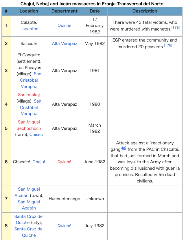 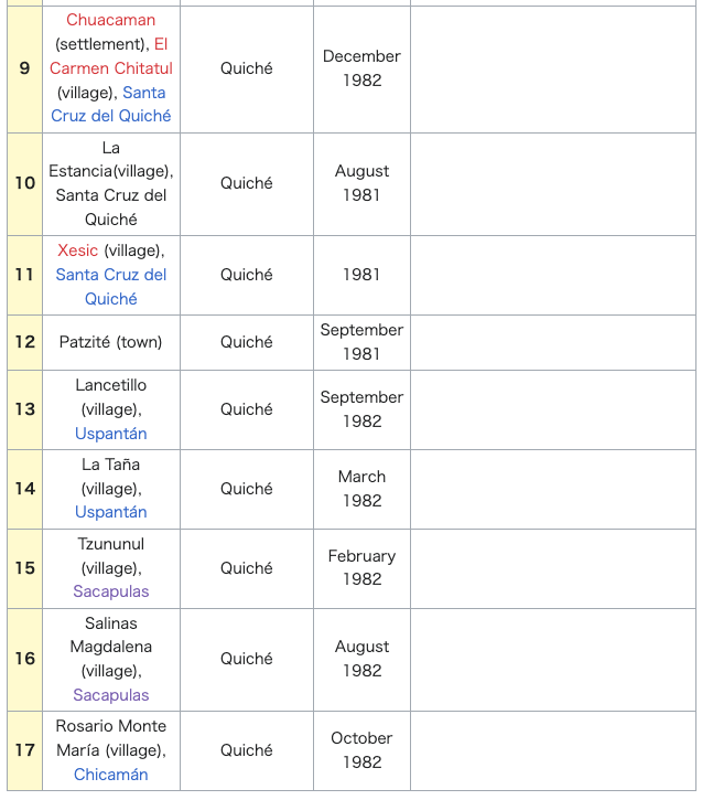 「グアテマラ内戦」を参照 |
| 1st century African oil palm See also: African oil palm  African oil palm plantation areas in Guatemala as of 2014.[52] There is a large demand within Guatemala and some of its neighbors for edible oils and fats, which would explain how the African oil palm became so prevalent in the country to the detriment of other oils, and which has allowed new companies associated to large capitals in a new investment phase[clarification needed] that can be found particularly in some territories that form the Northern Transversal Strip of Guatemala.[53] The investors are trying to turn Guatemala into one of the main palm oil exporters, in spite of a drop in price in international marketd. The most active palm oil regions found in Chisec and Cobán, in Alta Verapaz Department; Ixcán in Quiché Department, and Sayaxché, Petén Department, where Palmas del Ixcán, S.A. (PALIX) is located, both its own plantation and those of its subcontractors. Another active region is that of Fray Bartolomé de las Casas and Chahal in Alta Verapaz Department; El Estor and Livingston, Izabal Department; and San Luis, Petén, where Naturaceites operates.[53] |
1世紀 アフリカのアブラヤシ こちらも参照のこと: アフリカアブラヤシ 2014年現在のグアテマラにおけるアフリカアブラヤシのプランテーション地域[52]。 グアテマラとその近隣諸国には食用油脂に対する大きな需要があるため、アフリカアブラヤシが他の油脂を差し置いてグアテマラで普及し、特にグアテマラの北 部横断帯を形成するいくつかの地域で見られる新たな投資段階[要解説]において、大資本に関連する新たな企業を認めることになった。パーム油の生産が最も 盛んな地域は、アルタ・ベラパス県のチセックとコバン、キチェ県のイクスカン、ペテン県のサヤクスチェで、パルマス・デル・イクスカン社(PALIX)が 自社農園と下請け農園を所有している。もう1つの活発な地域は、アルタ・ベラパス県のフレイ・バルトロメ・デ・ラス・カサスとチャハル、イザバル県のエ ル・エストルとリビングストン、ペテン県のサン・ルイスで、ナチュラセイト社が操業している[53]。 |
| Guatemala portal icon Geography portal Carlos Arana Osorio Huehuetenango Guatemala Civil War El Quiché Fernando Romeo Lucas García Ixcán Izabal |
|
| https://en.wikipedia.org/wiki/Franja_Transversal_del_Norte |
リ ンク
文 献
そ の他の情報
Copyleft, CC, Mitzub'ixi Quq Chi'j, 1996-2099
![]()
☆
 ☆
☆