写真と民族誌のちがい
Differences between Photography and Ethnography
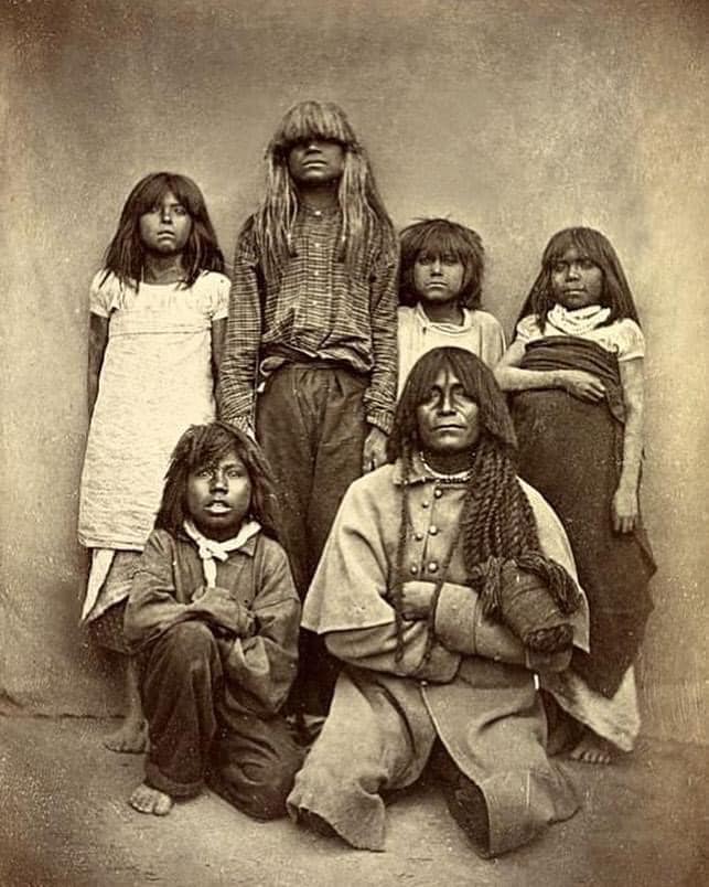
Llamados por primera vez los Pima, Akimel O'odham,
por los
exploradores españoles en el siglo XVII, se llamaron a sí mismos
"Akimel O'odham", que significa Pueblo del Río. Los pueblos piman, que
viven en la región del desierto de Sonora, son descendientes de la
cultura prehistórica Hohokam. foto: Indios Pima por Carlo Gentile, 1870.
池田光穂
| The Akimel O'odham
(O'odham for "river people"), also called the Pima, are a group of
Native Americans living in an area consisting of what is now central
and southern Arizona, as well as northwestern Mexico in the states of
Sonora and Chihuahua. The majority population of the two current bands
of the Akimel O'odham in the United States are based in two
reservations: the Keli Akimel Oʼodham on the Gila River Indian
Community (GRIC) and the On'k Akimel O'odham on the Salt River
Pima-Maricopa Indian Community (SRPMIC). The Akimel O'odham are closely related to the Ak-Chin O'odham, now forming the Ak-Chin Indian Community. They are also related to the Sobaipuri, whose descendants reside on the San Xavier Indian Reservation or Wa꞉k (together with the Tohono O'odham), and in the Salt River Indian Community. Together with the related Tohono O'odham ("Desert People") and the Hia C-ed O'odham ("Sand Dune People"), the Akimel O'odham form the Upper Oʼodham or Upper Pima (also known as Pima Alto). The short name, "Pima", is believed to have come from the phrase pi 'añi mac or pi mac, meaning "I don't know," which they used repeatedly in their initial meetings with Spanish colonists. The Spanish referred to them as the Pima.[2][3] This term was adopted by later English speakers: traders, explorers and settlers. |
アキメル・オダム(オダムは「川の民」の意)はピマとも呼ばれ、現在の
アリゾナ州中央部と南部、メキシコ北西部のソノラ州とチワワ州からなる地域に住むネイティブ・アメリカンのグループである。アキメル・オダムの現在の2つ
のバンドは、ギラ・リバー・インディアン・コミュニティ(GRIC)のケリ・アキメル・オダムと、ソルト・リバー・ピマ・マリコパ・インディアン・コミュ
ニティ(SRPMIC)のオンク・アキメル・オダムの2つの居留地を拠点としている。 アキメル・オダムはアクチン・オダムと密接な関係にあり、現在はアクチン・インディアン・コミュニティを形成しています。アキメル・オダムはサン・ザビエ ル・インディアン居留地またはワク(トホノ・オダムと共に)、ソルト・リバー・インディアン・コミュニティに居住するソバイプリとも親戚関係にあります。 関連するTohono O'odham(「砂漠の民」)およびHia C-ed O'odham(「砂丘の民」)と共に、アキメル・オダムはUpper Oʼodham またはUpper Pima(ピマ・アルトとしても知られる)を形成しています。 ピマ」という短い名前は、彼らがスペイン人入植者との最初の会合で繰り返し使った、「私は知らない」という意味のpi 'añi macまたはpi macというフレーズから来ていると考えられています。スペイン人は彼らをピマ族と呼んだ[2][3]。この言葉は後に英語を話す人々(貿易商、探検家、 入植者)によって採用された。 |
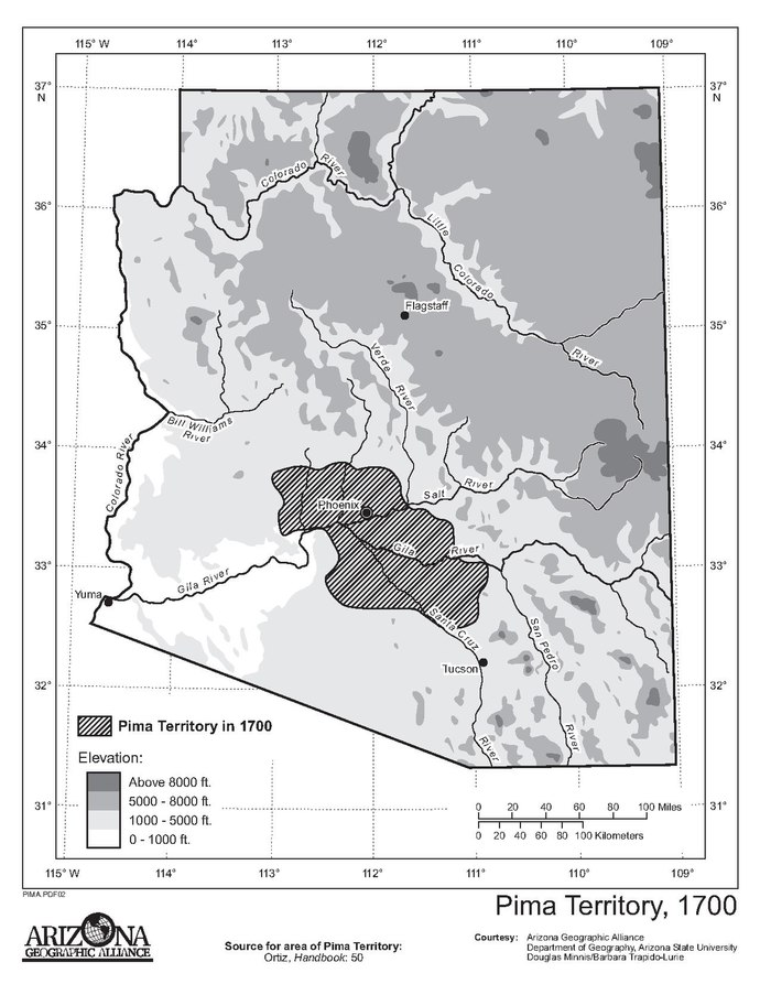 History
prior to 1688 History
prior to 1688The Pima Indians called themselves Othama until the first account of interaction with non-Native Americans was recorded. Spanish missionaries recorded Pima villages known as Kina, Equituni and Uturituc. European Americans later corrupted the miscommunication into Pimos, which was adapted to Pima river people. The Akimel Oʼodham people today call their villages District #1 – U's kehk (Blackwater), District #2 – Hashan Kehk (Saguaro Stand), District #3 – Gu꞉U Ki (Sacaton), District #4 – Santan, District #5 – Vah Ki (Casa Blanca), District #6 – Komatke (Sierra Estrella Mountains), and District #7 – Maricopa Colony.[4] The Akimel Oʼodham (known as the Pima to anthropologists) are a subgroup of the Upper Oʼodham or Upper Pima (also known as Pima Alto), whose lands were known in Spanish as Pimería Alta. These groups are culturally related. They are thought to be culturally descended from the group classified in archaeology as the Hohokam.[5] The term Hohokam is a derivative of the Oʼodham word Huhugam (pronounced hoo-hoo-gahm), which is literally translated as "those who have gone before," meaning "The Ancestors." The Pima Alto or Upper Pima groups were subdivided by scholars on the basis of cultural, economic and linguistic differences into two main groupings: One was known commonly as the Pima or River Pima. Since the late 20th century, they have been called by their own name, or endonym: Akimel Oʼotham Akimel O'odham (Akimel Au-Authm, meaning "River People", often simply called Pima, by outsiders, lived north of and along the Gila, the Salt, and the Santa Cruz rivers in what is today defined as Arizona) On'k Akimel O'odham (On'k Akimel Au-Authm – "Salt River People," lived and farmed along the Salt River), now included in the Salt River Indian Reservation. Keli Akimel O'otham (Keli Akimel Au-Authm, oft simply Akimel O'odham – "Gila River People", lived and farmed along the Gila River), now known as the Gila River Indian Community (GRIC) Ak-Chin O'odham (Ak-Chin Au-Authm),[6] Ak-Chin Indian Community Sobaipuri, (also simply called Sobas, called by the neighboring Akimel O'odham as Ṣáṣavino – "spotted"), originally lived in the valleys of the San Pedro River and Upper Santa Cruz River. In the early 18th century, they were gradually driven out of the lower San Pedro River valley. In the middle of the century, their remaining settlements along the upper San Pedro River were broken up by Arivaipa and Pinaleño Apache attacks. They moved west, seeking refuge among the Tohono O'odham and Akimel O'odham, with whom they merged. The other peoples are the Tohono O'odham or Desert Pima, enrolled in the Tohono O'odham Nation. Tohono O'odham ("Desert People"); the neighboring Akimel O'odham called them Pahpah Au-Authm or Ba꞉bawĭkoʼa – "eating tepary beans", which was pronounced Papago by the Spanish. They lived in the semi-arid deserts and mountains south of present-day Tucson, Tubac, and south of the Gila River[7] Kuitatk (kúí tátk) Sikorhimat (sikol himadk) Wahw Kihk (wáw kéˑkk) San Pedro (wiwpul) Tciaur (jiawul dáhăk) Anegam (ʔáˑngam – "desert willow") Imkah (ʔiˑmiga) Tecolote (kolóˑdi, also cú´kud kúhūk) Hia C-eḍ O'odham ("Sand Dune People", also known by the neighboring O'odham as Hia Tadk Ku꞉mdam – "Sand Root Crushers,"[8] commonly known as "Sand Pimas," lived west and southwest of the Tohono O'odham in the Gran Desierto de Altar of the Sonoran Desert between the Ajo Range, the Gila River, the Colorado River and the Gulf of California south into northwestern Sonora, Mexico. There they were known to the Tohono O'odham as Uʼuva꞉k or Uʼuv Oopad, named after the Tinajas Altas Mountains.) Areneños Pinacateños or Pinacateños[9] (lived in the Sierra Pinacate, known as Cuk Do'ag by the Hia C-eḍ O'odham in the Cabeza Prieta Mountains in Arizona and Sonora) Areneños (lived in the Gran Desierto around the mountains, which were home to the Areneños Pinacateños) The Akimel O'odham lived along the Gila, Salt, Yaqui, and Sonora rivers in ranchería-style villages. The villages were set up as a loose group of houses with familial groups sharing a central ramada and kitchen area. Brush "Olas Ki:ki" (round houses) were built around this central area. The Oʼodham are matrilocal, with daughters and their husbands living with and near the daughter's mother. Familial groups tended to consist of extended families. The Akimel Oʼodham also lived seasonally in temporary field houses in order to tend their crops. The O'odham language, variously called O'odham ñeʼokĭ, O'odham ñiʼokĭ or Oʼotham ñiok, is spoken by all O'odham groups. There are certain dialectal differences, but they are mutually intelligible and all O'odham groups can understand one another. Lexicographical differences have arisen among the different groups, especially in reference to newer technologies and innovations. The ancient economy of the Akimel O'odham was primarily subsistence, based on farming, hunting and gathering. They also conducted extensive trading. The prehistoric peoples built an extensive irrigation system to compensate for arid conditions.[5] It remains in use today. Over time the communities built and altered canal systems according to their changing needs. The Akimel Oʼodham were experts in the area of textiles and produced intricate baskets as well as woven cloth. Prior to the arrival of Europeans, their primary military rivals were the Apache and Yavapai, who raided their villages at times due to competition for resources. The latter tribes were more nomadic, depending primarily on hunting and gathering, and would raid the more settled groups who cultivated foods. They established some friendly relations with the Apache. |
1688年以前の歴史 ピマ・インディアンは、非ネイティブ・アメリカンとの最初の交流が記録されるまで、自分たちをオタマと呼んでいました。スペイン人宣教師は、キナ、エキ トゥニ、ウトゥリトゥクと呼ばれるピマ族の村を記録しました。ヨーロッパ系アメリカ人は、後にこの誤った呼び方をピモス(Pimos)に改め、ピマ川の人 々に適応させました。アキメル・オードハムの人々は現在、自分たちの村を第1地区-ウズ・ケク(ブラックウォーター)、第2地区-ハシャン・ケク(サガ ロ・スタンド)、第3地区-グ꞉ウ・キ(サカトン)、第4地区-サンタン、第5地区-ヴァ・キ(カサ・ブランカ)、第6地区-コマトケ(シエラ・エストレ ラ山脈)、第7地区-マリコパ・コロニーと呼んでいる[4]。 アキメル・オオダム(人類学者にはピマとして知られる)は、アッパー・オオダムまたはアッパー・ピマ(ピマ・アルトとしても知られる)のサブグループであ り、その土地はスペイン語でピメリア・アルタとして知られていた。これらのグループは文化的に関連している。ホホカムという言葉は、Oʼodhamの言葉 Huhugam(発音はhoo-hoo-gahm)から派生したもので、直訳すると "先人たち "という意味である。 ピマ・アルトまたはアッパー・ピマ・グループは、文化的、経済的、言語的な差異に基づいて、学者たちによって2つの主なグループに細分化されました: ひとつは、一般的にピマ族またはリバー・ピマ族として知られているものです。20世紀後半から、彼らは自分たちの名前(エンドネーム)で呼ばれるようにな りました: アキメル・オオダム アキメル・オオダム(Akimel Au-Authm、「川の民」の意、外部からは単にピマと呼ばれることも多い。) On'k Akimel O'odham (On'k Akimel Au-Authm - "Salt River People"、ソルト・リバー沿いに住み農業を営んでいた)、現在はソルト・リバー・インディアン居留地に含まれる。 ケリ・アキメル・オオタム(Keli Akimel Au-Authm、または単にAkimel O'odham-「ギラ川の人々」、ギラ川沿いに住み農業を営んでいた)、現在はギラ川インディアン・コミュニティ(GRIC)として知られる。 アクチン・オダム(Ak-Chin Au-Authm)、[6] アクチン・インディアン・コミュニティ ソバイプリ(単にソバとも呼ばれ、隣接するアキメル・オダムからはṢál_1E63↩avino-「斑点」と呼ばれる)は、もともとサンペドロ川とサンタ クルーズ川上流の渓谷に住んでいた。18世紀初頭、彼らはサンペドロ川下流域から徐々に追い出された。世紀中頃、サンペドロ川上流に残っていた彼らの集落 は、アリバイパ族とピナレーニョ族アパッチ族の攻撃によって崩壊した。彼らは西に移動し、トホノ・オダムとアキメル・オダムに避難し、彼らは彼らと合併し ました。 他の民族はトホノ・オダムまたはデザート・ピマで、トホノ・オダム・ネイションに登録されています。 トホノ・オダム(「砂漠の人々」)は、近隣のアキメル・オダム(Akimel O'odham)からはPahpah Au-AuthmまたはBa꞉bawĭa(「テパリー豆を食べる」)と呼ばれ、スペイン人からはパパゴ(Papago)と発音されました。彼らは現在の ツーソン、トゥバック、ギラ川の南の半乾燥砂漠と山に住んでいた[7]。 クイタットク(kúí tátk) シコルヒマット (sikol himadk) Wahw Kihk (wáw kém_2D1↩kk) サンペドロ(wiwpul) ティアウール(jiawul dáhăk) アネガム(ʔáˑngam - 「砂漠の柳) イムカ(ʔiˑmiga) テコロテ(kolóˑdi、cú´kud kúhūkでも可) Hia C-eḍ O'odham(「砂丘の人々」、近隣のO'odhamからはHia Tadk Ku꞉mdam(「砂の根を砕く人々」[8]、通称「砂ピマス」とも呼ばれる、 「彼らはトホノ・オダムの西と南西、アジョ山脈、ギラ川、コロラド川、カリフォルニア湾に挟まれたソノラ砂漠のグラン・デシエルト・デ・アルタルに住み、 メキシコのソノラ州北西部まで南下した。そこではTohono O'odhamにUʼuva꞉kまたはUʼuv Oopadとして知られており、Tinajas Altas山脈にちなんで名付けられた)。 Areneños PinacateñosまたはPinacateños[9](アリゾナ州とソノラ州のカベサ・プリエタ山脈にあるシエラ・ピナカテに住み、ハイア・チェ ル・オダム族はCuk Do'agと呼んでいた。) アレネーニョ族(ピナカテーニョのアレネーニョ族が住んでいた山の周辺のグラン・デシエルトに住んでいた) アキメル・オダム族はギラ川、ソルト川、ヤキ川、ソノラ川沿いの牧場スタイルの村に住んでいた。村は緩やかな家々の集まりで、家族グループは中央のラマー ダとキッチンを共有していた。ブラシの「Olas Ki:ki」(丸い家)は、この中央エリアを囲むように建てられている。Oʼodhamは母系社会で、娘とその夫は娘の母親と同居し、その近くに住む。家 族集団は拡大家族で構成される傾向がある。Akimel Oʼodhamはまた、作物の世話をするために、季節ごとに臨時の畑の家に住んでいた。 オダムの言葉は、オダム語(O'odham ñeʼokĭ)、オダム語(O'odham ñiʼokĭ)、オダム語(Oʼotham ñiok)と呼ばれ、オダム族のすべてのグループで話されています。方言の違いはありますが、お互いに理解することができ、すべてのオダム・グループはお 互いを理解することができます。特に新しい技術や革新に関連して、異なるグループ間で語彙の違いが生じています。 アキメル・オダム族の古代の経済は、主に農耕、狩猟、採集に基づく自給自足でした。また、大規模な交易も行っていた。先史時代の人々は、乾燥した環境を補 うために大規模な灌漑システムを構築した。時代とともに、コミュニティは変化するニーズに応じて運河システムを構築し、変更した。 Akimel Oʼodhamは織物の専門家で、織布だけでなく複雑な籠も生産していた。ヨーロッパ人が到着する前、彼らの主な軍事的ライバルはアパッチ族とヤヴァパイ 族で、彼らは資源争奪のために彼らの村を襲撃したこともあった。後者の部族はより遊牧的で、主に狩猟と採集に頼っており、食物を栽培する定住した部族を襲 撃していました。彼らはアパッチ族と友好関係を築きました。 |
| History after 1694 Pima dwellings of traditional and brick construction in 1900 Kaviu, a Pima elder, photographed around 1907 by Edward S. Curtis Initially, the Akimel O'odham experienced little intensive colonial contact. Early encounters were limited to parties traveling through the territory or community members visiting settlements to the south. The Hispanic era (A.D.1694–1853) of the Historic period began with the first visit by Father Kino to their villages in 1694. The Pima Revolt, also known as the O'odham Uprising or the Pima Outbreak, was a revolt of Pima people in 1751 against colonial forces in Spanish Arizona and one of the major northern frontier conflicts in early New Spain. Contact was infrequent with the Mexicans during their rule of southern Arizona between 1821 and 1853. The Akimel Oʼodham were affected by introduced European elements, such as infectious diseases to which they had no immunity, new crops (cultigens, e.g., wheat), livestock, and use of tools and goods made of metal. Euroamerican contacts with the Akimel Oʼodham in the middle Gila Valley increased after 1846 as a result of the Mexican–American War. The Akimel Oʼodham traded and gave aid to the expeditions of Stephen Watts Kearny and Philip St. George Cooke on their way to California. After Mexico's defeat, it ceded the territory of what is now Arizona to the United States, with the exception of the land south of the Gila River. Soon thereafter the California Gold Rush began, drawing Americans to travel to California through the Mexican territory between Mesilla and the Colorado River crossings near Yuma, on what became known as the Southern Emigrant Trail. Travelers used the villages of the Akimel Oʼodham as oases to recover from the crossing of unfamiliar deserts. They also bought new supplies and livestock to support the journey across the remaining deserts to the west. Two young Pima Indian school girls, ca.1900 The American era (A.D. 1853–1950), began in 1853 with the Gadsden Purchase, when the US acquired southern Arizona. New markets were developed, initially to supply immigrants heading for California. Grain was needed for horses of the Butterfield Overland Mail and for the military during the American Civil War. As a result, the Akimel Oʼodham experienced a period of prosperity. The Gila River Indian Community (GRIC) was established in 1859. The 1860 census records the Pima Villages as Agua Raiz, Arenal, Casa Blanca, Cachanillo, Cerrito, Cerro Chiquito, El Llano, and Hormiguero.[10] After the American Civil War, numerous Euroamerican migrants came to settle upstream locations along the Gila, as well as along the lower Salt River. Due to their encroachment and competition for scarce resources, interaction between Native American groups and the Euro-American settlers became increasingly tense. The U.S. government adopted a policy of pacification and confinement of Native Americans to reservations. Uncertainty and variable crop yields led to major settlement reorganizations. The establishment of agency headquarters, churches and schools, and trading posts at Vahki (Casa Blanca) and Gu U ki (Sacaton) during the 1870s and 1880s led to the growth of these towns as administrative and commercial centers, at the expense of others. By 1898 agriculture had nearly ceased within the GRIC. Although some Akimel Oʼodham drew rations, their principal means of livelihood was woodcutting. The first allotments of land within Gila River were established in 1914, in an attempt to break up communal land. Each individual was assigned a 10-acre (40,000 m2) parcel of irrigable land located within districts irrigated by the Santan, Agency, Blackwater, and Casa Blanca projects on the eastern half of the reservation. In 1917, the allotment size was doubled to include a primary lot of irrigable land and a secondary, usually non-contiguous 10-acre (40,000 m2) tract of grazing land. The most ambitious effort to rectify the economic plight of the Akimel Oʼodham was the San Carlos Project Act of 1924, which authorized the construction of a water storage dam on the Gila River. It provided for the irrigation of 50,000 acres (200 km2) of Indian and 50,000 acres (200 km2) of non-Indian land. For a variety of reasons, the San Carlos Project failed to revitalize the Oʼodham farming economy. In effect the project halted the Gila river waters, and the Akimel O'odham no longer had a source of water for farming. This began the famine years. Many Oʼodham have believed these wrong and misguided government policies were an attempt of mass genocide. Over the decades, the U.S. government promoted assimilation, forcing changes on to the Akimel Oʼodham in nearly every aspect of their lives. Since World War II, however, the Akimel Oʼodham have experienced a resurgence of interest in tribal sovereignty and economic development. The community has regained its self-government and are recognized as a tribe. In addition, they have developed several profitable enterprises in fields such as agriculture and telecommunications, and built several gaming casinos to generate revenues. They have begun to construct a water delivery system across the reservation in order to revive their farming economy. |
1694年以降の歴史 1900年当時の伝統的なレンガ造りのピマ族の住居 エドワード・S・カーティスによって1907年頃に撮影されたピマの長老カビウ。 当初、アキメル・オオダム族は植民地との濃密な接触をほとんど経験しませんでした。初期の接触は、テリトリーを旅行する一行か、コミュニティのメンバーが 南の入植地を訪れる程度であった。歴史時代のヒスパニック時代(西暦1694年~1853年)は、1694年にキノ神父が初めて彼らの村を訪れたことから 始まりました。ピマ族の反乱は、オダムの蜂起またはピマ族の大発生としても知られ、1751年にスペイン領アリゾナで植民地軍に対するピマ族の反乱であ り、初期ニュー・スペインにおける主要な北部開拓紛争の1つであった。 1821年から1853年の間、メキシコ人がアリゾナ州南部を支配していた間、メキシコ人との接触はほとんどなかった。Akimel Oʼodhamは、免疫のない伝染病、新しい作物(小麦などのカルチゲン)、家畜、金属製の道具や商品の使用など、ヨーロッパから持ち込まれた要素の影響 を受けた。 ギラ渓谷中部のAkimel Oʼodhamとヨーロッパ系アメリカ人の接触は、米墨戦争の結果として1846年以降に増加した。Akimel Oʼodhamはカリフォルニアに向かうStephen Watts KearnyとPhilip St. メキシコは敗戦後、ギラ川以南を除く現在のアリゾナ州の領土をアメリカに割譲した。その後間もなくカリフォルニア・ゴールドラッシュが始まり、アメリカ人 はメシーヤとユマ近くのコロラド川を渡る間のメキシコ領を通り、南部移民トレイルとして知られるカリフォルニアへ向かうようになった。旅行者たちは、慣れ ない砂漠の横断から回復するためのオアシスとして、アキメル・オダムの村々を利用した。また、西に残された砂漠を越える旅を支えるために、新たな物資や家 畜を購入した。 2人の若いピマ・インディアンの女子生徒、1900年頃 アメリカの時代(西暦1853年~1950年)は、1853年にアメリカがアリゾナ州南部を獲得したガズデン購入から始まった。当初はカリフォルニアへ向 かう移民を供給するために、新しい市場が開発された。バターフィールド陸路郵便の馬や南北戦争中の軍用にも穀物が必要とされた。その結果、Akimel Oʼodhamは繁栄の時代を経験した。ギラ・リバー・インディアン・コミュニティ(GRIC)は1859年に設立された。1860年の国勢調査では、ピ マ村はアグア・ライズ、アレナル、カサ・ブランカ、カチャニージョ、セリート、セロ・チキート、エル・ラノ、ホルミゲーロと記録されている[10]。 アメリカ南北戦争後、多くのヨーロッパ系アメリカ人がギラ川上流とソルト川下流に定住するようになった。彼らの侵入と希少資源をめぐる競争により、ネイ ティブ・アメリカン・グループとヨーロッパ系アメリカ人入植者の間の交流はますます緊迫していった。アメリカ政府は、ネイティブ・アメリカンをなだめ、居 留地に閉じ込める政策を採用しました。不確実性と農作物の不作により、入植地は大規模に再編成されました。1870年代から1880年代にかけて、ヴァヒ キ(カサ・ブランカ)とグ・ウ・キ(サカトン)に代理店本部、教会、学校、交易所が設立され、これらの町は行政および商業の中心地として成長し、他の町は 犠牲になりました。 1898年までにGRIC内の農業はほぼ停止した。Akimel Oʼodhamの中には配給を受ける者もいたが、彼らの主な生計手段は薪割りであった。ギラ・リヴァーでの最初の土地割当ては1914年に確立され、共同 所有地を分割する試みであった。保留地の東半分にあるサンタン、エージェンシー、ブラックウォーター、カサ・ブランカ・プロジェクトによる灌漑地区内に位 置する灌漑可能な土地で、各個人に10エーカー(40,000㎡)の区画が割り当てられました。1917年には割当面積が2倍に拡大され、灌漑可能な1次 区画と、通常は連続しない10エーカー(40,000㎡)の2次区画の放牧地が含まれるようになりました。 アキメル・オダムの経済的窮状を改善するための最も野心的な努力は、ギラ・リバーに貯水ダムを建設することを許可した1924年のサン・カルロス・プロ ジェクト法であった。5万エーカー(200km2)のインディアンの土地と、5万エーカー(200km2)の非インディアンの土地の灌漑が規定された。さ まざまな理由から、サン・カルロス・プロジェクトはオードハムの農業経済を活性化させることはできなかった。事実上、プロジェクトはギラ川の水を止め、ア キメル・オオダムは農業用の水源を失った。これが飢饉の始まりだった。多くのオダムは、このような政府の誤った政策は集団虐殺の試みだと信じてきた。 数十年にわたり、アメリカ政府は同化を促進し、アキメル・オダムの生活のほぼすべての面で変化を強いた。しかし第二次世界大戦後、アキメル・オオダムは部 族の主権と経済発展への関心が復活した。コミュニティは自治権を取り戻し、部族として認められている。さらに、農業や電気通信などの分野で収益性の高い事 業をいくつか開発し、収入を得るためにカジノをいくつか建設した。彼らは農業経済を復活させるため、居留地全域に水を供給するシステムの建設に着手してい る。 |
| Akimel O'odham and the Salt River Fine Pima baskets, photographed around 1907 by Edward S. Curtis The Akimel O'odham ("River People") have lived on the banks of the Gila and Salt Rivers since long before European contact. Their way of life (himdagĭ, sometimes rendered in English as Him-dag) was and is centered on the river, which is considered holy. The term Him-dag should be clarified, as it does not have a direct translation into the English language, and is not limited to reverence of the river. It encompasses a great deal because O'odham him-dag intertwines religion, morals, values, philosophy, and general world view which are all interconnected. Their world view/religious beliefs are centered on the natural world, and this is pervasive throughout their culture. The Gila and Salt Rivers are currently dry, due to the (San Carlos Irrigation project) upstream dams that block the flow and the diversion of water by non-native farmers. This has been a cause of great upset among all of the Oʼodham. The upstream diversion in combination with periods of drought, led to lengthy periods of famine that were a devastating change from the documented prosperity the people had experienced until non-native settlers engaged in more aggressive farming in areas that were traditionally used by the Akimel Oʼodham and Apache in Eastern Arizona. This abuse of water rights was the impetus for a nearly century long legal battle between the Gila River Indian Community and the United States government, which was settled in favor of the Akimel Oʼodham and signed into law by George W. Bush in December 2005. As a side note, at times during the monsoon season the Salt River runs, albeit at low levels. In the weeks after December 29, 2004, when an unexpected winter rainstorm flooded areas much further upstream (in Northern Arizona), water was released through dams on the river at rates higher than at any time since the filling of Tempe Town Lake in 1998, and was a cause for minor celebration in the Salt River Pima-Maricopa Indian Community. The diversion of the water and the introduction of non-native diet is said to have been the leading contributing factor in the high rate of diabetes among the Akimel Oʼodham tribe. |
アキメル・オダムとソルト・リバー 1907年頃、エドワード・S・カーティスによって撮影されたピマ族のバスケット。 アキメル・オダム(「川の民」)はヨーロッパ人が接触するずっと前からギラ川とソルト川のほとりに住んでいました。 彼らの生活様式(himdagĭ、英語ではHim-dagと表記されることもあります)は神聖視される川を中心に成り立っています。ヒムダグという言葉は 英語に直接訳すことはできないし、川への畏敬の念に限定されるものではないからだ。なぜならオダムのヒムダグは、宗教、道徳、価値観、哲学、そして一般的 な世界観、これらすべてが相互に関連しているからだ。彼らの世界観/宗教的信念の中心は自然界であり、それは彼らの文化全体に浸透している。 ギラ川とソルト川は、上流にあるダム(サン・カルロス灌漑プロジェクト)が流れをせき止めていることと、外来農民による水の分水により、現在干上がってい る。これはOʼodhamの全住民にとって大きな動揺の原因となっている。上流への分水は干ばつの時期と重なり、長期の飢饉を招き、アリゾナ州東部のアキ メル・オダムとアパッチが伝統的に使用してきた地域で、外来入植者がより積極的な農業に従事するまで、人々が経験してきた記録された繁栄から壊滅的な変化 をもたらした。この水利権の濫用は、ギラ・リバー・インディアン・コミュニティとアメリカ合衆国政府との約1世紀にわたる法廷闘争のきっかけとなった。余 談だが、モンスーンの季節には、水位は低いものの、ソルト・リバーが流れることがある。2004年12月29日以降の数週間、予期せぬ冬の暴風雨で(アリ ゾナ州北部の)さらに上流地域が洪水に見舞われた際、1998年のテンピ・タウン湖の湛水以来の高水位で川のダムから放水され、ソルト・リバー・ピマ・マ リコパ・インディアン・コミュニティのささやかな祝賀行事となった。水の迂回と外来食の導入は、Akimel Oʼodham部族の糖尿病罹患率を高めた主な要因であると言われている。 |
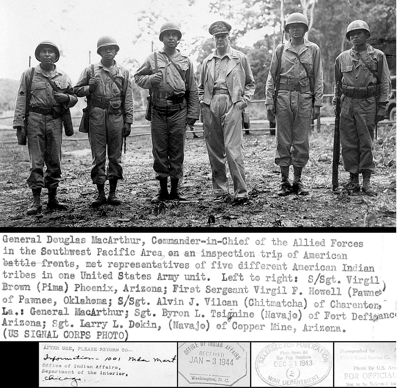 Modern life Modern lifeGeneral Douglas MacArthur meeting Navajo, Pima, Pawnee and other Native American troops Douglas Miles (Akimel O'odham–San Carlos Apache), artist, youth advocate, and founder of Apache Skateboard[11] As of 2014, the majority of the population lives in the federally recognized Gila River Indian Community (GRIC). In historic times a large number of Akimel O'odham migrated north to occupy the banks of the Salt River, where they formed the Salt River Pima-Maricopa Indian Community (SRPMIC). Both tribes are confederations of two distinct ethnicities, which include the Maricopa. Within the O'odham people, four federally recognized tribes in the Southwest speak the same language: they are called the Gila River Indian Community (Keli Akimel O'odham – "Gila River People"); the Salt River Pima-Maricopa Indian Community (Onk Akimel O'odham – "Salt River People"); the Ak-Chin Indian Community (Ak-Chin O'odham); and the Tohono O'odham Nation (Tohono O'odham – "Desert People"). The remaining band, the Hia C-ed O'odham ("Sand Dune People"), are not federally recognized, but reside throughout southwestern Arizona. Today the GRIC is a sovereign tribe residing on more than 550,000 acres (2,200 km2) of land in central Arizona. The community is divided into seven districts (similar to states) with a council representing individual subgovernments. It is self-governed by an elected Governor (currently Gregory Mendoza), Lieutenant Governor (currently Stephen Roe-Lewis) and 18-member Tribal Council. The council is elected by district with the number of electees determined by district population. There are more than 19,000 enrolled members overall. The Gila River Indian Community is involved in various economic development enterprises that provide entertainment and recreation: three gaming casinos, associated golf courses, a luxury resort, and a western-themed amusement park. In addition, they manage various industrial parks, landfills, and construction supply. The GRIC is also involved in agriculture and runs its own farms and other agricultural projects. The Gila River Indian Reservation is home of Maricopa (Piipaa, Piipaash or Pee-Posh – "People") and Keli Akimel O'odham (also Keli Akimel Au-Authm – "Gila River People", a division of the Akimel O'odham – "River People"). The Salt River Pima-Maricopa Indian Community is smaller in size. It also has a government of an elected President and tribal council. They operate tribal gaming, industrial projects, landfills and construction supply. The Salt River Pima-Maricopa Indian Community (SRPMIC) is home of the Onk Akimel O'odham (also On'k Akimel Au-Authm – "Salt River People", a division of the Akimel O'odham – "River People"), the Maricopa of Lehi (call themselves Xalychidom Piipaa or Xalychidom Piipaash – "People who live toward the water", descendants of the refugee Halchidhoma), the Tohono O'odham ("Desert People") and some Keli Akimel O'odham (also Keli Akimel Au-Authm – "Gila River People", another division of the Akimel O'odham – "River People"). The Ak-Chin Indian Community is located in the Santa Cruz Valley in Arizona. The community is composed mainly of Ak-Chin O'odham (Ak-Chin Au-Authm, also called Pima, another division of the Akimel O'odham – "River People") and Tohono O'odham, as well as some Yoeme. As of 2000, the population living in the community was 742. Ak-Chin is an O'odham word that means the "mouth of the arroyo" or "place where the wash loses itself in the sand or ground." The Keli Akimel O'odham and the Onk Akimel O'odham have various environmentally based health issues related to the decline of their traditional economy and farming. They have the highest prevalence of type 2 diabetes in the world, much more than is observed in other U.S. populations. While they do not have a greater risk than other tribes, the Pima people have been the subject of intensive study of diabetes, in part because they form a homogeneous group.[12] The general increased diabetes prevalence among Native Americans has been hypothesized as the result of the interaction of genetic predisposition (the thrifty phenotype or thrifty genotype), as suggested by anthropologist Robert Ferrell in 1984[12] and a sudden shift in diet during the last century from traditional agricultural crops to processed foods, together with a decline in physical activity. For comparison, genetically similar O'odham in Mexico have only a slighter higher prevalence of type 2 diabetes than non-O'odham Mexicans.[13] |
現代の生活 ダグラス・マッカーサー将軍がナバホ、ピマ、ポーニー、その他のネイティブ・アメリカン部隊と会談する様子 ダグラス・マイルズ(アキメル・オダム=サン・カルロス・アパッチ)、アーティスト、青少年擁護者、アパッチ・スケートボードの創設者[11]。 2014年現在、人口の大半は連邦公認のギラ・リバー・インディアン・コミュニティ(GRIC)に住んでいる。歴史上、多数のアキメル・オダムが北に移住 してソルト・リバーのほとりを占拠し、ソルト・リバー・ピマ・マリコパ・インディアン共同体(SRPMIC)を形成した。両部族はマリコパ族を含む2つの 異なる民族の連合体である。 オダム族では、南西部の4つの連邦公認部族が同じ言語を話します。ギラ・リバー・インディアン・コミュニティ(Keli Akimel O'odham、「ギラ川の人々」)、ソルト・リバー・ピマ・マリコパ・インディアン・コミュニティ(Onk Akimel O'odham、「塩川の人々」)、アクチン・インディアン・コミュニティ(Ak-Chin O'odham、「アクチン・オダム」)、トホノ・オダム・ネーション(Tohono O'odham、「砂漠の人々」)と呼ばれています。残りの1バンド、ヒア・セッド・オダム(「砂丘の民」)は連邦非公認だが、アリゾナ州南西部に居住し ている。 現在、GRICはアリゾナ州中央部の55万エーカー(2,200km2)以上の土地に居住する主権部族である。コミュニティは7つの地区(州に似ている) に分かれており、それぞれのサブガバメントを代表する評議会がある。選挙で選ばれたガバナー(現グレゴリー・メンドーサ)、副ガバナー(現ステファン・ ロー・ルイス)、18人のメンバーからなる部族評議会によって自治されている。評議会は地区ごとに選出され、選挙人の数は地区の人口によって決まる。全体 で19,000人以上の登録会員がいます。 ギラ・リバー・インディアン・コミュニティは、娯楽とレクリエーションを提供するさまざまな経済開発事業に携わっています。3つのゲーミング・カジノ、関 連ゴルフコース、高級リゾート、西部をテーマにした遊園地などです。さらに、さまざまな工業団地、埋立地、建設資材を管理している。GRICは農業にも携 わっており、自社農場やその他の農業プロジェクトも運営している。ギラ・リバー・インディアン居留地にはマリコパ(Piipaa、Piipaash、 Pee-Posh=「人々」)とケリ・アキメル・オダム(Keli Akimel Au-Authm=「ギラ・リバーの人々」、アキメル・オダムの一部門=「川の人々」)が住んでいる。 ソルトリバー・ピマ・マリコパ・インディアン・コミュニティは規模が小さい。ソルト・リバー・ピマ・マリコパ・インディアン・コミュニティは規模が小さ い。部族賭博、産業プロジェクト、埋立地、建設資材の供給を行っている。ソルトリバー・ピマ・マリコパ・インディアン共同体(SRPMIC)には、オン ク・アキメル・オダム(On'k Akimel Au-Authm、アキメル・オダム「川の民」の一部門)、リーハイのマリコパ(自らをXalychidom PiipaaまたはXalychidom Piipaashと呼ぶ、「水に向かって生きる人々」)が住んでいます、 難民ハルキドマの子孫)、トホノ・オダム(「砂漠の民」)、ケリ・アキメル・オダム(ケリ・アキメル・オウ・アウトム「ギラ川の民」、アキメル・オダムの 別部門「川の民」)の一部である。 アクチン・インディアン・コミュニティはアリゾナ州サンタ・クルーズ・バレーに位置する。このコミュニティは主にアクチン・オダム(Ak-Chin Au-Authm、ピマとも呼ばれ、アキメル・オダムのもう1つの部門である「川の民」)とトホノ・オダム、そして若干のヨエメで構成されている。 2000年現在の人口は742人。アクチンはオダム族の言葉で、「アロヨの河口」または「流れが砂や地面に流れ込む場所」を意味する。 ケリ・アキメル・オダム族とオンク・アキメル・オダム族は、伝統的な経済と農業の衰退に関連して、環境に基づくさまざまな健康問題を抱えている。彼らは2 型糖尿病の有病率が世界で最も高く、米国の他の集団よりもはるかに多い。他の部族よりもリスクが高いわけではないが、ピマ族は均質な集団を形成しているこ ともあり、糖尿病に関する集中的な研究の対象となっている[12]。 アメリカ先住民の糖尿病有病率の一般的な増加は、1984年に人類学者ロバート・フェレルが示唆したように、遺伝的素因(倹約的表現型または倹約的遺伝子 型)と、前世紀における伝統的な農作物から加工食品への急激な食生活の変化、および身体活動の低下との相互作用の結果であるという仮説が立てられている [12]。比較のために、遺伝的に類似したメキシコのオダムの2型糖尿病の有病率は、非オダムのメキシコ人よりもわずかに高いだけである[13]。 |
| Customs The Akimel O'odham associate great importance to the names of individuals. From age ten until the time of marriage, neither boys nor girls were allowed to speak their own names out loud. The Pima Indians believed such an act would bring bad luck to the children and their future. Similarly, people in the tribe do not say aloud the names of deceased people, in order to avoid bad luck by calling their spirits back among the living. But the word or words in the name are not dropped from the language.[citation needed] The people gave their children careful oral instruction in moral, religious and other matters. Their ceremonies often included set speeches, in which the speaker would recite portions of their cosmic myth. Such a recounting was especially important in the preparation for war. These speeches were adapted for each occasion but the general context was the same.[citation needed] Traditionally, the Pimas lived in a thatched wattle-and-daub hut, as seen by the early white settlers who ventured into their country:[14] Their homes are jacales which are huts made of mats of reed-grass cut in half and built n the form of a vault on arched sticks. The top is covered with these mats, thick enough to resist the weather, Inside, they have only a petate on which to sleep, and gourds in which to carry and store water. Notable Akimel O'odham Natalie Diaz, poet, language activist, former professional basketball player Ira Hayes (1923–1955), Marine paratrooper and flagraiser at the Battle of Iwo Jima Douglas Miles, artist, social worker Big Chief Russell Moore (1912–1983), jazz trombonist |
習慣 アキメル・オダム族は、個人の名前を非常に重要視します。10歳から結婚するまで、男の子も女の子も自分の名前を口に出して話すことは許されなかった。ピ マ・インディアンは、そのような行為は子供とその将来に不運をもたらすと信じていた。同様に、ピマ・インディアンの人々は、亡くなった人の名前を声に出し て言うことはしない。しかし、名前に含まれる単語や言葉が言語から削除されることはない[要出典]。 人々は子供たちに道徳的、宗教的、その他の事柄を口頭で丁寧に教えた。彼らの儀式にはしばしば、話し手が宇宙神話の一部を朗読するスピーチが含まれてい た。このような朗読は戦争の準備において特に重要であった。これらのスピーチはそれぞれの機会に適応されたが、一般的な文脈は同じであった[要出典]。 伝統的に、ピマス族は、彼らの国に足を踏み入れた初期の白人入植者が見たように、藁葺きとダブの小屋に住んでいた[14]。 彼らの住居はジャカレと呼ばれる、葦草のマットを半分に切り、アーチ型の棒の上に丸天井の形をした小屋である。上部はこのマットで覆われ、十分に厚く、風 雨に耐えることができる。内部には、寝るためのペテートと、水を運び貯めるためのひょうたんしかない。 著名なアキメル・オダム ナタリー・ディアス(詩人、言語活動家、元プロバスケットボール選手 アイラ・ヘイズ(1923-1955)、硫黄島の戦いにおける海兵隊の落下傘兵、旗手 ダグラス・マイルズ、芸術家、ソーシャルワーカー ビッグ・チーフ・ラッセル・ムーア(1912-1983)、ジャズ・トロンボーン奏者 |
RUMBLE Web Exclusive: Gary Giddins and Joe Licari on "Big Chief" Russell Moore |
|
| https://en.wikipedia.org/wiki/Akimel_O%27odham |
今 日のテーマは、写真と民族誌(エスノグラフィー)のちがいについて考えよう。
**
【種 々、議論中】
**
結 局、「真実」を両方とも映すものらしい が、その両方とも、作者の主観というものが入るという点で共通である。
こ こらあたりの議論では、作者の主観が、 混じることについては、当否さまざまな意見が出たけれども、作者の主観の入り込まない写真も民族誌 もありえないという結論になった
リ ンク
- ︎真理・真実とはなにか▶︎人類学における真実と嘘▶︎︎▶︎▶︎︎▶︎▶︎︎▶︎▶︎︎▶︎▶︎
文 献
そ
の他の情報