琉球弧
Ryukyu Arc


Map of the Ryukyu
☆琉
球弧(Ryukyu Arc)は、九州の南から琉球列島に沿って台湾の北東まで延びる、約1,200キロメートル(750マイル)にわたる島弧である。[2][3][4]
琉球海溝に沿ってフィリピン海プレートがユーラシアプレートの下に北西方向に沈み込んでいる、収束するプレート境界の一部に沿って位置している。[3]
[4][5] 。この弧は全体として北東から南西方向に伸びており、太平洋の北西、東シナ海の南東に位置している。[6]
活火山の列島である沖縄トラフと琉球海溝に平行に走っている。[7]
琉球弧は地形学に基づいて、北から南に、北部琉球、中部琉球、南部琉球に区分することができる
。トカラ海峡は北琉球と中琉球を約130°Eで隔て、慶良間海門は中琉球と南琉球を約127°Eで隔てている。[2][5][7]
弧の地質学的単位には火成岩、堆積岩、変成岩があり、古生代から新生代までの年代にわたっている。
| The
Ryukyu Arc is an island arc which extends from the south of Kyushu
along the Ryukyu Islands to the northeast of Taiwan, spanning about
1,200 kilometres (750 mi).[2][3][4] It is located along a section of
the convergent plate boundary where the Philippine Sea Plate is
subducting northwestward beneath the Eurasian Plate along the Ryukyu
Trench.[3][4][5] The arc has an overall northeast to southwest trend
and is located northwest of the Pacific Ocean and southeast of the East
China Sea.[6] It runs parallel to the Okinawa Trough, an active
volcanic arc, and the Ryukyu Trench.[7] The Ryukyu Arc, based on its
geomorphology, can be segmented from north to south into Northern
Ryukyu, Central Ryukyu, and Southern Ryukyu; the Tokara Strait
separates Northern Ryukyu and Central Ryukyu at about 130˚E while the
Kerama Gap separates Central Ryukyu and Southern Ryukyu at about 127
˚E.[2][5][7] The geological units of the arc include igneous,
sedimentary, and metamorphic rocks, ranging from the Paleozoic to
Cenozoic in age. |
琉
球弧は、九州の南から琉球列島に沿って台湾の北東まで延びる、約1,200キロメートル(750マイル)にわたる島弧である。[2][3][4]
琉球海溝に沿ってフィリピン海プレートがユーラシアプレートの下に北西方向に沈み込んでいる、収束するプレート境界の一部に沿って位置している。[3]
[4][5] 。この弧は全体として北東から南西方向に伸びており、太平洋の北西、東シナ海の南東に位置している。[6]
活火山の列島である沖縄トラフと琉球海溝に平行に走っている。[7]
琉球弧は地形学に基づいて、北から南に、北部琉球、中部琉球、南部琉球に区分することができる
。トカラ海峡は北琉球と中琉球を約130°Eで隔て、慶良間海門は中琉球と南琉球を約127°Eで隔てている。[2][5][7]
弧の地質学的単位には火成岩、堆積岩、変成岩があり、古生代から新生代までの年代にわたっている。 |
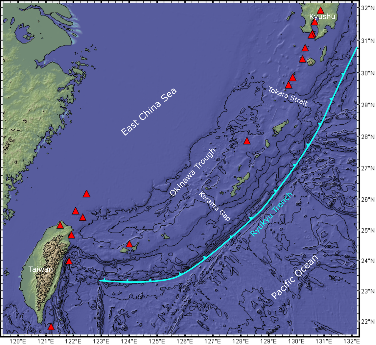
 Map of the Ryukyu Arc. Red triangles represent volcanoes based on Aster Volcano Archive (NASA-METI) data. Contours in 1 km intervals. Figure made with GeoMapApp (www.geomapapp.org) / CC BY / CC BY (Ryan et al., 2009).[1] |
 琉球弧の地図。赤い三角形は、Aster Volcano Archive(NASA-METI)のデータに基づく火山を表す。等高線は1km間隔。図はGeoMapApp(www.geomapapp.org) を使用して作成。CC BY / CC BY(Ryan et al., 2009)。[1] |
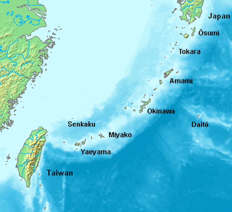
| Geological setting A number of studies defined the extent of the Ryukyu Arc geographically and morphologically into three parts: Northern Ryukyu, which includes the Ōsumi Islands; Central Ryukyu, which includes Amami Islands and Okinawa Islands; Southern Ryukyu, which includes Miyako Islands and Yaeyama Islands.[2][7] The northernmost and southernmost parts of the Ryukyu Arc terminate in Kyushu and Taiwan, respectively.[8] The geological and structural features of Southern Ryukyu are quite different from those of Northern and Central Ryukyu; Southern Ryukyu, and Northern and Central Ryukyu may have developed in disparate geological settings before the middle Miocene.[2] Accretionary complexes in Northern and Central Ryukyu are considered as the extension of the Outer Zone of Southwest Japan,[7][9][10] whereas metamorphic rocks in Southern Ryukyu are associated with the Inner Zone of Southwest Japan.[11] The arc might be united into the present configuration in the Pliocene-Pleistocene due to different rates of southeastward migration as tectonics proceeded.[2] 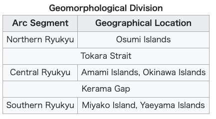 |
地質学的状況 多くの研究により、琉球弧の範囲は地理的および形態学的に、大隅諸島を含む北部琉球、奄美諸島と沖縄諸島を含む中部琉球、宮古諸島と八重山諸島を含む南部琉球の3つに定義されている。[2][7] 琉球弧の最北端と最南端は、それぞれ九州と台湾で終わっている。[8] 南琉球の地質学的および構造的特徴は、北琉球および中央琉球のそれとはかなり異なっている。南琉球、北琉球、中央琉球は、中新世中期以前に異なる地質学的 環境で形成された可能性がある。[2] 北琉球および中央琉球の付加コンプレックスは、西南日本のアウターゾーンの延長と考えられている 一方、南琉球の変成岩は西南日本の内帯に関連していると考えられている。[11] 造山運動が進むにつれ、南東方向への移動速度に差が生じたため、弧は鮮新世から更新世にかけて現在の形にまとまった可能性がある。[2]  |
| Okinawa Trough The Okinawa Trough is the back-arc basin of the Ryukyu Arc, and has been formed by lithospheric extension of the continental Eurasian Plate.[3] Extensional grabens, about 10 km wide and about 50–100 km long, with en echelon alignment can be found in the middle to southern parts of Okinawa Trough.[3][5] Of the whole Okinawa Trough, the southern part is the most evolved and active, in that, its maximum depth, which is greater than other parts, is about 2200 m.[4] The Okinawa Trough accommodates terrigenous sediments from the continental shelf of Asia and the Ryukyu Arc at a high rate.[4]  Schematic of island arc system. Seismicity The Ryukyu Arc is a site of active seismicity characterised by shallow earthquakes, given the ongoing convergence between the Philippine Sea Plate and Eurasian Plate.[8] Seismic data of earthquakes have been used to detect seismic structures below the Ryukyu Arc.[12] Low seismic velocity zones, which are possibly associated with the upwelling of magma, have been discovered beneath active volcanoes and the Okinawa Trough.[12] 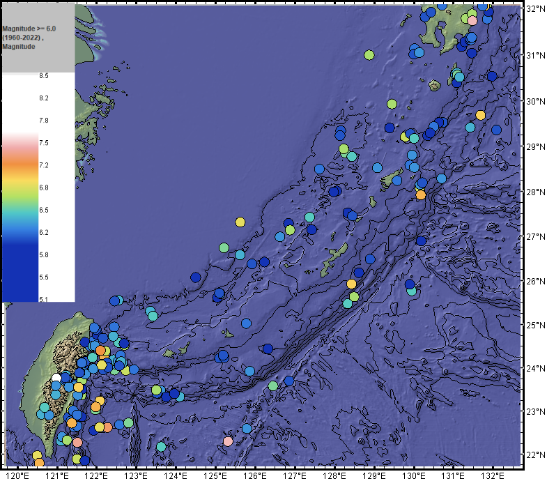 M≥6.0 (1960-2022) Earthquakes in the Ryukyu Arc. Earthquake data from USGS-ANSS Catalog. Contours in 1 km interval. Figure made with GeoMapApp (www.geomapapp.org) / CC BY / CC BY (Ryan et al., 2009).[1] Volcanoes An active volcanic front lies 100 km above the Wadati-Benioff zone (a planar zone of seismicity at the interface between the subducting and overriding plates) in Northern Ryukyu and gradually fades off in Central and Southern Ryukyu.[5] |
沖縄トラフ 沖縄トラフは琉球弧の背弧海盆であり、ユーラシア大陸プレートのリソスフェアの伸張によって形成された。[3] 幅約10km、長さ約50~100kmの伸張型グラベンが、沖縄トラフの中部から南部にかけて、エシュロン配列で確認されている ある。[3][5] 沖縄トラフ全体のうち、南の部分が最も発達しており、活動的である。その最大深度は他の部分よりも深く、約2200mである。[4] 沖縄トラフは、アジア大陸棚および琉球弧から運ばれてくる陸源堆積物を大量に受け入れている。[4]  島弧システムの概略図。 地震活動 琉球弧は、フィリピン海プレートとユーラシアプレートの収束が現在も続いているため、浅い地震を特徴とする活発な地震地帯である。[8] 琉球弧の地下の地震構造を検出するために、地震のデータが使用されている。[12] 低速度地震帯は、マグマの湧昇に関連している可能性があり、活火山や沖縄トラフの地下で発見されている。[12]  M≥6.0 (1960-2022) 琉球弧における地震。USGS-ANSSカタログによる地震データ。等深線は1km間隔。図はGeoMapApp (www.geomapapp.org) / CC BY / CC BY (Ryan et al., 2009) により作成。[1] 火山 活火山の分布域は、琉球列島の北部では、海溝型地震帯(沈み込むプレートとそれに覆い被さるプレートの境界にある地震帯)から100km上にあるが、中部および南部では徐々に減少する。[5] |
| Geological units Major, but not all, geological units of the Ryukyu Arc are herein summarised. 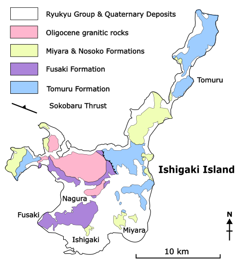 Simplified Geological Map of Ishigaki Island, after Nakae (2013)[6] and Nishimura (1998)[11] 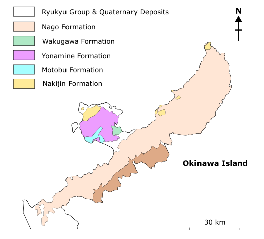 Simplified Geological Map of northern Okinawa Island, after Miyagi et al., (2013).[13] Motobu and Yonamine Formations The Motobu and Yonamine Formations are Permian rocks that constitute the basement of the Motobu peninsula of Okinawa Island, Central Ryukyu.[14] The Motobu Formation consists mainly of limestone interbedded with chert and phyllite.[15] The limestone contains foraminifera fossils of Permian age.[8] The Yonamine Formation, with strata of interbedded phyllite, slate, sandstone, limestone, greenstone, and chert,[15] underlies the Motobu Formation[16] and contains Permian corals.[17] Tomuru Formation The Tomuru Formation is distributed in the Iriomote and Ishigaki Islands of the Yaeyama Islands, Southern Ryukyu.[7][11][18] The formation has an age of 220–190 Ma (million years ago) (Late Triassic-Early Jurassic) and comprises ultramafic rocks and high pressure/temperature (P/T) metamorphic rocks, i.e., metagabbro and mafic, siliceous, and pelitic schists.[11][19] Fusaki Formation The Fusaki Formation, located at the Ishigaki Island and Taketomi Island of the Yaeyama Islands in Southern Ryukyu,[18] comprises weakly metamorphosed olistromal rocks: allochthonous blocks of chert, mudstone, sandstone, and limestone are embedded in a muddy matrix.[11] The metamorphic age of this formation ranges from 145 to 130 Ma (Early Cretaceous) and was determined by K-Ar phengitic micas dating.[11] Radiolaria data show that the formation accreted in the Toarcian in the Early Jurassic.[6] This formation is part of an accretionary complex of a Middle Jurassic subduction zone.[11] On Ishigaki Island, this formation is thrusted beneath the Tomuru Formation along the Sokobaru thrust[11] and is intruded by Oligocene granitic rocks, named the Omoto Pluton.[6] Nakijin Formation The Nakijin Formation is a 450–500m thick deposit of limestone, basalt, and a minor amount of calcareous siltstone, tuffaceous and calcareous mudstone.[14] Fossil records of ammonites and halobiids in this formation suggest a Late Triassic age.[14] The Nakijin Formation can be found in Central Ryukyu, i.e., Sesoko Island and the northwestern part of the Motobu peninsula of Okinawa Island.[14] This formation overlies the Yonamine Formation along a reverse fault.[14] Shimanto Group The Shimanto Group is a set of metamorphic rocks dated from Early Cretaceous to earliest Miocene which are associated with the Shimanto belt.[7][20] The Shimanto belt is an accretionary complex in the Outer Zone of Southwest Japan which extends from Honshu, Shikoku, and Kyushu to Northern and Central Ryukyu.[2] The group comprises sedimentary and metasedimentary rocks metamorphosed up to greenschist facies, including flysch-type sandstone and slate with mafic greenstones.[7] Deformations such as northwest-dipping, isoclinal, overturned folds and SE-verging thrust faults can be found in the Shimanto Group of Central and Northern Ryukyu.[7] In Okinawa Island, Central Ryukyu, the Shimanto Group is separated into the Nago Formation and the Kayo Formation.[21] The Nago Formation comprises pelitic and mafic schist, phyllite, and slate, with minor chert and limestone,[21] and crops out most of northern Okinawa Island.[15] Though only trace fossils have been found in the formation, it is thought to be Cretaceous to early Eocene in age by correlations with other formations in the island.[21] The Kayo Formation features beds of turbidite containing mudstone, sandstone, and nummulite fossils that indicate middle Eocene age.[22] ] It underlies the Nago Formation along a northwest-dipping thrust fault.[21] Thrust-folding and metamorphism of the formation suggest a trench origin.[22][20] Miyara and Nosoko Formations The Eocene Miyara and Nosoko Formations crop out the Yaeyama Islands, Southern Ryukyu.[7] The Miyara Formation is a south-southwest-dipping succession of conglomerate, sandstone, shale, and limestone deposited along the coast of Ishigaki Island.[8] A large variety of marine fossils—e.g., calcareous algae, foraminifera, corals, echinoderms, bryozoans, and gastropods— have been preserved in the limestones, and molluscs were also found in the conglomerate.[8] Foraminifera and calcareous algae in the limestones suggest a late Eocene age.[8] The Nosoko Formation is a 300m thick sequence of tuff, volcanic sandstone and breccia, and lavas with dykes, sills, and other small intrusions.[8] This formation is widely exposed at the Nosoko peninsula in northern Ishigaki Island.[8] It also lies conformably above the Miyara Formation.[22] Paleomagnetic data of the Nosoko Formation indicate a mean deflection of the magnetic direction at about 30˚ clockwise away from the expected pole.[23] This data, coupled with radiometric ages, suggest that Southern Ryukyu might have rotated about 25˚ with respect to the Asian continent in the Miocene at 6–10 Ma.[23] Yaeyama Group The Yaeyama Group is a set of sedimentary rocks comprising primarily sandstone with interbeds of conglomerate, limestone, mudstone, and coal seams, and cropping out the Yaeyama Islands, Southern Ryukyu.[2][7] The age of the group is early Miocene, as suggested by paleontological data.[18] Coal seams, cross laminae, and trace fossils reveal that the group is possibly derived from sediments in a continental shelf.[2][7] The group shows less deformation such as tilting and folding than the Eocene formations of Southern Ryukyu, suggesting that Southern Ryukyu has been stable since the early Miocene.[2] Shimajiri Group The Shimajiri Group consists of an upper and a lower member. The upper member (Shinzato) of late Miocene or Pliocene age consists of tuff and shale; the lower member (Yonabaru) of Miocene age contains shale interbedded with siltstone and sandstone.[24] The Shimajiri Group is the first geological unit to be found across Northern, Central, and Southern Ryukyu.[2][7] Northern, Central Ryukyu, and Southern Ryukyu may have had different basins and tectonic settings prior to the Late Miocene (the age of deposition of the group).[2] Despite being widely distributed across the East China Sea, the Ryukyu Arc and its forearc, the group does not occur in the southern Okinawa Trough.[4] Rifting of the southern Okinawa Trough preceded the deposition of the group.[4] Ryukyu Group The Ryukyu Group is Pleistocene deposits formed after the development of the Shimajiri Group but before Holocene sediments had been deposited.[25] It is distributed in Central and Southern Ryukyu and is marked by a distinct unconformity above the Shimajiri Group.[25] The group comprises predominantly the Ryukyu Limestone and Terrace Deposits of sand and gravel.[25] The Ryukyu Limestone is generally 40–60m thick and is characterised by post-depositional faulting, which resulted in the formation of terraces and the associated sediments (Terrace Deposits).[25] Following the deposition of the Ryukyu Limestone, prevalent northwest–southeast faulting across the Ryukyu Arc resulted in an episode of dome-like uplifting of basement rocks in the Ryukyu Islands, named the 'Uruma Movement'.[26] Tectonics 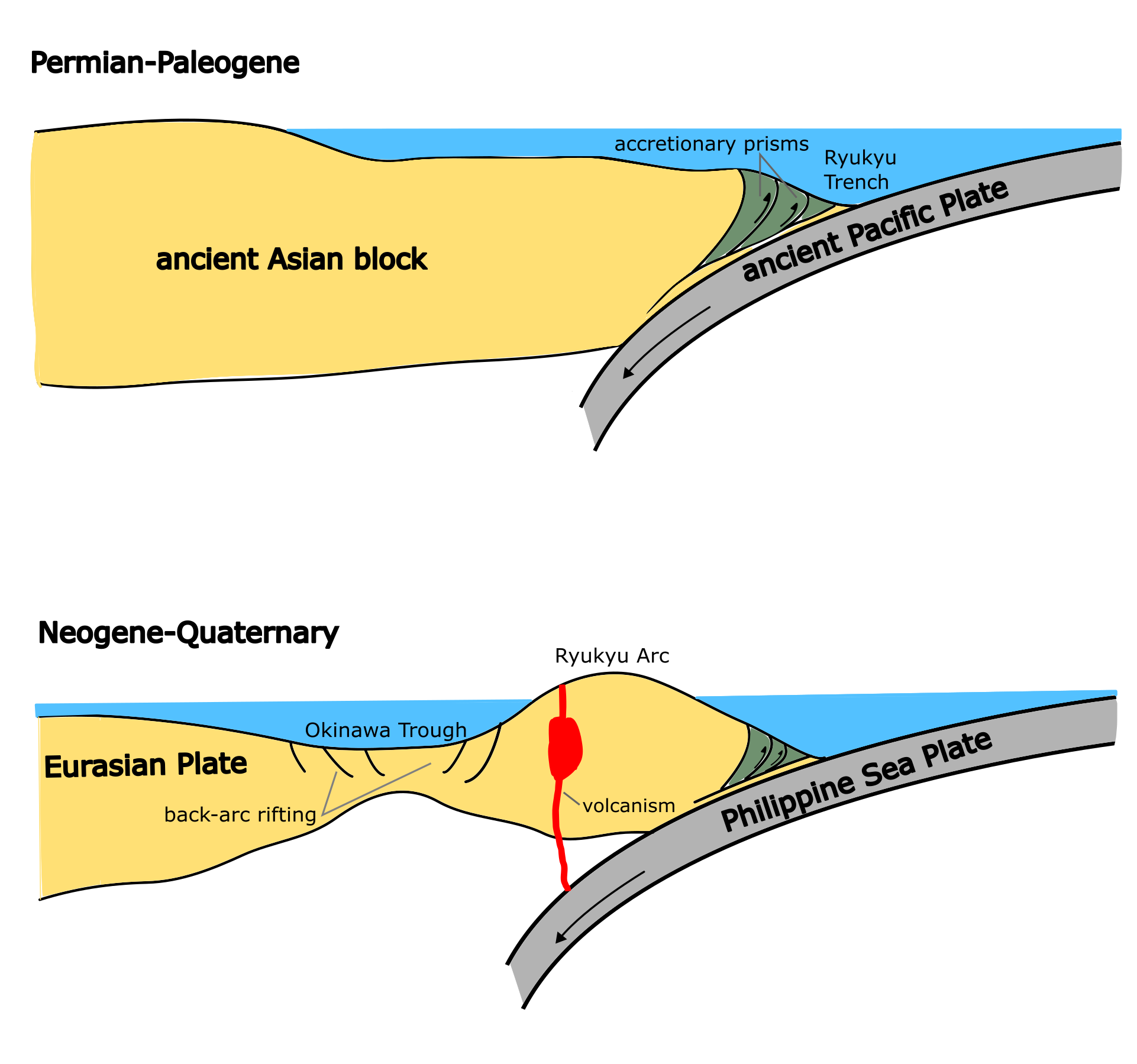 Evolution of the Ryukyu Arc. Modified from Ujiie (1994).[22] Along the Ryukyu Trench, the Philippine Sea Plate is subducting northwestward under the Eurasian Plate at an estimated velocity of 5–7 cm/year.[27] The subduction angles become increasingly oblique to the arc toward south.[27] Global Positioning System data show that southern Kyushu and the Ryukyu Arc migrate southeastward (toward the Ryukyu Trench) relative to Eurasia, as compared to the westward-northwestward migration of other arcs of Japan.[28] Permian-Paleogene Permian-Jurassic accretionary prisms accumulated along the eastern side of Pangea, where the ancient Pacific Plate subducted under the ancient Asian continental block.[29] Vast regions of the Japan Island Arc, including the Ryukyu Arc, developed from accretions pertinent to the subduction during the Jurassic.[29] Fossil and paleomagnetic evidence from the Shimanto Group suggests that subduction of a young oceanic plate occurred in the Late Cretaceous (about 70 Ma) to the Paleogene.[29] Subduction and accretion may have stopped in late Eocene prior to the deposition of the Neogene-Quaternary Shimajiri Group.[22] Neogene-Quaternary Deposition of continental shelf sediments (the Yaeyama Group) took place in Southern Ryukyu, which at the time was stable and had no crustal movement, during early Miocene.[2][6][22] After a cessation of subduction around 10–6 Ma, the Philippine Sea Plate resumed subducting since the late Miocene (about 6 Ma), leading to back-arc spreading of the Okinawa Trough.[30] Initial rifting of the northern Okinawa Trough may have caused a counterclockwise rotation in Northern Ryukyu and southern Kyushu after 6 Ma.[30] Meanwhile, paleomagnetic data record a clockwise rotation of Southern Ryukyu after 10 Ma.[23] Seismic reflection surveys indicate initial rifting of the southern part of the Okinawa Trough in the early Pleistocene, which gave rise to distinct tectonic processes, i.e., sedimentation, crustal doming, erosion, and subsidence.[4] The emergence of the Ryukyu Arc, together with the subsidence of the Okinawa Trough, may have occurred in the late Pleistocene (1.7–0.5 Ma) after the development of the Shimajiri Group and before that of the Ryukyu Group.[22] The back-arc rifting and associated sedimentation in the southern Okinawa Trough have continued since 2 Ma.[4] |
地質単位 琉球列島の主な地質単位(すべてではない)を以下にまとめる。  石垣島簡易地質図、中江(2013)[6]および西村(1998)[11]による  沖縄島北部の簡略化された地質図、宮城ほか(2013年)[13]による 本部層と与那嶺層 本部層と与那嶺層は、琉球列島中部の沖縄島本部半島の基盤を構成するペルム紀の岩石である。[14]本部層は主に石灰岩からなり、珪岩や片岩が互層をなし ている。[15]石灰岩には ペルム紀の有孔虫化石を含む。[8] 与那嶺層は、片岩、粘板岩、砂岩、石灰岩、緑色岩、およびチャートが互層をなす地層であり、[15] 与那嶺層は本部層の下位に位置し、[16] ペルム紀のサンゴを含む。[17] トムル層 トムル層は、南琉球の八重山諸島のうち西表島と石垣島に分布している。この地層は2億2000万年前から1億9000万年前( 後期三畳紀 - 前期ジュラ紀)であり、超苦鉄質岩と高温高圧(P/T)変成岩、すなわちメタガバロ岩や苦鉄質岩、珪質岩、泥質岩からなる。[11][19] フサキ層 フサキ層は、琉球列島南部の八重山諸島の石垣島と竹富島に分布し[18]、弱変成のオリストロマ層からなる。すなわち、チャート、泥岩、砂岩、石灰岩の他 地性ブロックが泥質のマトリックスに埋め込まれている。 。この地層の変成年代は1億4500万年から1億3000万年前(白亜紀前期)であり、K-Ar法によるフェンジャイトマイカの年代測定によって決定され た。放散虫のデータによると、この地層はジュラ紀前期のトアル期に付加したことが示されている。この地層は、ジュラ紀中期の沈み込み帯の付加コンプレック スの一部である。[11] 石垣島では、この地層は底倉断層に沿って登村層の下に押し込まれており[11]、漸新世の花崗岩類、大本岩体によって貫入されている。[6] 今帰仁層 今帰仁層は、厚さ450~500mの石灰岩、玄武岩、および少量の石灰質シルト岩、凝灰質泥岩、石灰質泥岩の堆積物である。[14] この層から発見されたアンモナイトとハルビアン類の化石記録は、後期三畳紀の地質年代を示唆している。三畳紀後期の地層であることを示している。 四万十帯 四万十帯は、四万十帯に関連する前期白亜紀から始新世前期の変成岩の集合体である。[7][20] 四万十帯は西南日本の外帯に位置する付加コンプレックスであり、本州、四国、九州から琉球列島北部および中央部にかけて広がっている。[2] このグループは、緑色片岩相まで変成した堆積岩および変成岩からなり、苦鉄質緑色岩を含むフリッシュタイプの砂岩や粘板岩を含む。 沖縄島、中央琉球では、四万十層群は名護層と嘉陽層に分けられる。[21] 名護層は、泥質岩と苦鉄質岩の片岩、千枚岩、粘板岩からなり、少量のチャートと石灰岩を含む。[21] 沖縄島北部の大部分で露頭している。[ 15] この地層からは痕跡化石しか発見されていないが、島内の他の地層との対比から、白亜紀から始新世前期のものと推定されている。[21] 加用層の特徴は、泥岩、砂岩、および始新世中期を示すヌンムライト化石を含むタービダイトの層である。それは北西傾斜の断層に沿って名護層の下位にある。 [21] この地層における衝上断層褶曲と変成作用は、海溝起源を示唆している。[22][20] 宮良層と野底層 始新世の宮良層と野底層は、南琉球の八重山諸島で露出している。[7] 宮良層は、石垣島の海岸沿いに堆積した、南南西に傾斜する礫岩、砂岩、頁岩、石灰岩の地層である。[8] 石灰岩には、 石灰藻、有孔虫、サンゴ、棘皮動物、苔虫、腹足類など、多種多様な海生化石が石灰岩に保存されており、軟体動物も礫岩から発見されている。[8] 石灰岩中の有孔虫や石灰藻は、後期始新世の年代を示唆している。[8] 野底層は、凝灰岩、火山性砂岩、角礫岩、および貫入岩である岩脈や岩板、その他の小規模な貫入岩を含む、厚さ300mの堆積物である。[8] この地層は、石垣島北部の野底半島で広く露出している。[8] また、宮良層の上位に整合的に位置している。[22] 野底層の古地磁気 野底層群の古地磁気データは、平均偏角が約30度で、予想される磁極から時計回りに離れていることを示している。[23] このデータと放射年代を組み合わせると、南琉球は600万~1000万年前の中新世にアジア大陸に対して約25度回転した可能性があることが示唆される。 [23] 八重山層群 八重山層群は、主に砂岩からなり、礫岩、石灰岩、泥岩、および石炭層が層をなす堆積岩の集合体であり、南琉球の八重山諸島から露出している。[2][7] この地層群の年代は、古生物学的データから、前期中新世であることが示唆されている。[1 8] 炭層、横の層理、生痕化石から、このグループは大陸棚の堆積物から派生した可能性があることが明らかになっている。[2][7] このグループは、南琉球の始新世層よりも傾動や褶曲などの変形が少ないことから、南琉球は始新世初期から安定していたことが示唆されている。[2] 島尻層群 島尻層群は上部層と下部層からなる。上部層(新里)は中新世後期から鮮新世のもので凝灰岩と頁岩からなり、下部層(与那原)は中新世のもので、シルト岩と 砂岩が混在する頁岩を含む。[24] 島尻層群は、琉球列島の北部、中部、南部にまたがって分布する最初の地質単位である。[2][7] 琉球列島の北部、中部、 琉球群の堆積年代である後期中新世以前には、北部、中部、南部の琉球では異なる地層や地質構造が存在していた可能性がある。[2] 琉球弧とその前弧は東シナ海に広く分布しているにもかかわらず、この群は沖縄トラフ南部には存在しない。[4] 沖縄トラフ南部の分裂は、この群の堆積に先行している。[4] 琉球層群 琉球層群は、島尻層群の形成後、完新世の堆積物が堆積される前に形成された更新世の堆積物である。[25] 琉球列島の中部および南部に分布しており、島尻層群の上部にはっきりとした不整合が認められる。[25] この層群は主に琉球石灰岩と砂礫のテラス堆積物から構成されている。[25] 琉球石灰岩は一般的に厚さ40~ 60mの厚さがあり、堆積後の断層運動によって特徴づけられ、その結果、段丘と関連堆積物(段丘堆積物)が形成された。[25] 琉球石灰岩の堆積後、琉球弧全体にわたって北西-南東方向に断層運動が顕著に起こり、琉球諸島では基盤岩がドーム状に隆起する現象が起こった。この現象は 「うるま運動」と名付けられた。[26] テクトニクス  琉球弧の進化。氏家(1994年)を改変。[22] 琉球海溝に沿って、フィリピン海プレートはユーラシアプレートの下に北西方向に沈み込んでおり、その速度は年間5~7cmと推定されている。[27] 沈み込みの角度は、南に向かうにつれて弧に対して次第に斜交するようになる。[27] 全地球測位システム(GPS)のデータによると、南九州と琉球弧はユーラシアプレートに対して南東方向(琉球海溝に向かって)に移動している。これは、他 の日本列島の弧が西から北西方向に移動しているのと対照的である。 ペルム紀 - 古第三紀 ペルム紀 - ジュラ紀付加プリズムはパンゲア大陸の東側で蓄積され、古代の太平洋プレートが古代のアジア大陸ブロックの下に沈み込んだ。[29] 琉球弧を含む日本列島弧の広大な地域は、ジュラ紀の沈み込みに関連する付加体から形成された。[29] 四万十層群の化石と古 四万十層群の化石と古地磁気学的証拠は、白亜紀後期(約7000万年前)から古第三紀にかけて、若い海洋プレートの沈み込みが発生したことを示唆してい る。[29] 新第三紀・第四紀の島尻層群の堆積に先立つ始新世後期には、沈み込みと付加が停止した可能性がある。[22] 新第三紀から第四紀 の堆積(八重山層群)は、当時安定しており地殻変動もなかった南琉球で始まった。これは中新世前期のことである。[2][6][22] 1060万年前頃に沈み込みが停止した後、フィリピン海プレートは中新世後期(約600万年前)から再び沈み込みを始め、 、沖縄トラフの背弧海嶺の形成につながった。[30] 沖縄トラフ北部の最初の分裂は、6 Ma以降、北琉球と南九州の反時計回りの回転を引き起こした可能性がある。[30] 一方、古地磁気データは、1 。反射法地震探査の結果では、沖縄トラフ南部の最初の分裂は更新世初期に起こったことが示されており、これは堆積、地殻ドーム化、浸食、沈降といった明確 な地質学的プロセスを引き起こした。[4] 琉球弧の隆起は、 島尻層群の形成後、琉球層群の形成前に、後期更新世(170万~50万年前)に起こった可能性がある。[22] 沖縄トラフ南部における背弧海台化とそれに伴う堆積作用は、200万年前から続いている。[4] |
| Izu–Bonin–Mariana Arc Geology of Taiwan |
伊豆-小笠原-マリアナ弧 台湾の地質 |
| https://en.wikipedia.org/wiki/Ryukyu_Arc |
|
リ ンク
文 献
そ の他の情報
Copyleft,
CC, Mitzub'ixi Quq Chi'j, 1996-2099